ROUTE: Long walk. Start Warren House Inn. Fernworthy reservoir. Thornworthy Tor. Middle Tor and Kestor. Batworthy Corner. Scorhill Down. Shovel Down. Fernworthy. Finish Warren House Inn. Distance 17km.
SITES OF INTEREST: Shovel Down Ceremonial complex, Round Pound and Kes Tor Settlements, Scorhill Stone Circle.
PUBLIC TRANSPORT: Walk originally based on the discontinued Transmoor Bus Service. The Warren House Inn is no longer served by a bus service. If you can get there this route may still be of use!
Shovel Down and Scorhill
Start at Warren House Inn. Take the path up hill just to the right of Warren House Inn as you face it. The initial part of this route is the same as that taken on the Warren House Inn: Fernworthy and Grey Wethers walk. From the Kings Oven Cairn head directly north to the entrance of Fernworthy Reservoir via the Hurston Ridge double stone row and passing the Heath Stone on the way in to Fernworthy Forest.
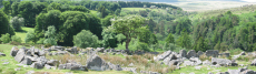
At the main parking and picnic area follow the path east around Fernworthy Reservoir. To the right of the path just before the dam is a particularly well preserved hut circle. Pass the dam and a little way into the woods is a path that descends and crosses the river valley. Beyond the small footbridge the path ascends through rhododendrons back to the dam on the other side. Head west, below the wall line, then head north to ascend to the top of Thornworthy Tor. On the northern slopes of Thornworthy Tor are settlements and Bronze Age field boundaries. Around 0.5 km to the NW the Gidleigh Long Stone can be seen. Head for the Long Stone. The terrain can be a little boggy to the NW of Thornworthy Tor - try a rectangular path heading due north, you will need to find a stile over the wall, and then square to the west, or alternatively try a rectangular path by heading west straight from the Thornworthy Tor and then heading square to the north.
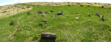
The Long Stone heads the first of the stone rows at Shovel Down. Head north following the row. The first double row descends the slope and not far away is the 4-fold cairn circle that heads another double row that forks off downhill in the direction of Batworthy corner. To the west is an extensive Bronze Age field system with numerous settlements along with the remains of a stone circle.
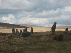
From Batworthy Corner follow the wall north to reach the Teign-e-ver Clapper Bridge. Around 200m north over the Bradford Leat is the Scorhill stone circle. Without a doubt the most impressive stone circle on Dartmoor. On the banks of the North Teign River along here can be found the Tolmen Stone, a holed stone said to have been used for fertility and healing rituals.
Head back round Batworthy Corner to take a look at the Round Pound. The Round Pound may have been Bronze Age in its origins but excavations by Lady Fox found evidence of later iron workings. The radial walls are thought to have arisen during a much later medieval period of occupation. Climb the northern slope of Kestor Rock. The slopes of Kestor are dotted with Bronze Age hut circles and field boundaries. Kestor Rock has a naturally formed rock basin which was once thought to have been created by "the Druids" - although it is conceivable that it might have been used for ritual purposes.
From Kestor Rock head to Middle Tor - on the way are reaves and hut circles. From Middle Tor head back along the eastern slopes of Thornworthy Tor to head back to the Fernworthy Dam and on to return to the Warren House Inn. If you have time stop for a well deserved pint!
External Links
Legendary Dartmoor: The Tolmen Stone
Page last updated 22/8/11