
Guide to the Monuments on Tavy Cleave and Watern Oke
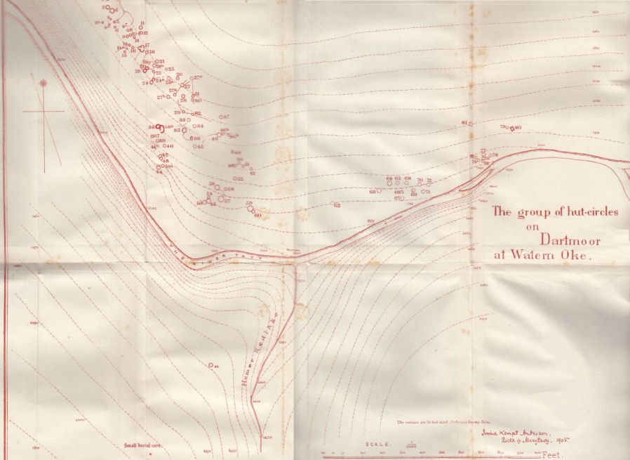
Table of Ritual and Burial Monuments on Tavy Cleave and Watern Oke
The following table lists the records currently in this Guide Map. For an explantion of the Guide Maps and a table of all 62 Guide Maps, follow this link: Guide List Table. Introductory text will be added to each guide list in 2025. Notes on duplication and omissions will appear below the table once checks have been finalised.
| Guide # | Butler | SiteID | Site Name | ShortName | Record Source | Map | Turner | HER | Photo | Unique? | Checked |
|---|---|---|---|---|---|---|---|---|---|---|---|
| 1 | 32.19 | 1219 | Hare Tor S.E. Cairn | CN:Hare Tor 1 | Butler | SX5547083680 | MDV3309 | N | Unique | 1 | |
| 2 | 32.19 | 1220 | Hare Tor S. Reported Cairn | CN:Hare Tor 2 | Butler | SX5520083660 | MDV3304 | N | Unique | 1 | |
| 3 | 32.20.1 | 1222 | Hare Tor N.1 Cairn | CN:Hare Tor N1 | Butler | SX5518284570 | MDV3574 | Y | Unique | 1 | |
| 4 | 32.20.2 | 1223 | Hare Tor N.2 Reported Cairn | CN?Hare Tor N2 | Butler | SX5506984462 | MDV131976 | Y | Unique | 1 | |
| 5 | 4256 | Hare Tor N.3 Cairn | CN Hare Tor N3 | HER | SX5528784578 | MDV103626 | Y | Unique | 1 | ||
| 6 | 3233 | Watern Oke (N of) Clearance Cairn | CN?WaternOke | Grinsell | SX5635084520 | MDV3310 | N | Unique | 1 | ||
| 7 | 2717 | Lower Rattle Brook Clearance Cairn | CN:LowerRat 1 | HER | SX5624084550 | MDV128670 | N | Unique | 1 |
Notes on possible duplications and omissions
Hare Tor N.3 Reported Cairn This record originated with HER MDV103626 which has a grid reference to the east of Hare Tor N.1.The entry for MDV103626 is now linked to Butler's Hare Tor N.2. We now have 3 records here representing the 3 grid references (one from HER and two from Butler). Do they represent two or three cairns? Fieldwork needed to clarify.PS. These notes are to assist untangling complicated records and are neither permanent nor a criticism of the HER who do a fantastic job! The author finds it easier to systematically work through these records (2000+ of them) and add these notes, which are then to be communicated with the HER, if appropriate, it is a pragmatic way of dealing with lots of data without continually stopping and starting.
Tavy Cleave and Watern Oke Guide Map
Guidance for walkers: The monuments featured in this database are archaeological treasures and need to be protected and preserved - please do not disturb any sites. Please check access and firing times before visiting sites, not all sites listed are on open access land. Firing ranges and boundaries of open access areas are marked on the OL28 OS Dartmoor Explorer map. Please stick to the country code and consider giving support to the numerous agencies that help to keep Dartmoor a fabulous natural and historic environment!
List of Ritual and Burial Monuments on Tavy Cleave and Watern Oke
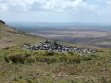
Hare Tor S.E. Cairn
OS Map: SX 55470 83680
HER record: MDV3309
ShortName: CN:Hare Tor 1
Butler map: 32.19
Grinsell: PET 16
Notes: HER: A damaged cairn 7.4 metres in diameter and 0.4 metres high, bisected by an excavation trench. Surveyed in 1998 as part of the Willsworthy project.
Nearby sites: SX55478368
Hare Tor S. Reported Cairn
OS Map: SX 55200 83660
HER record: MDV3304
ShortName: CN:Hare Tor 2
Butler map: 32.19
Grinsell: PET 17
Barrow Report: 25
Notes: HER: Anderson describes a cairn of 3.4 metres by 0.5 metres high excavated in 1905. Worth mentions a feature at SX 55218368 but this cairn has not been identified at this location since.
Nearby sites: SX55208366
Hare Tor N.1 Cairn
OS Map: SX 55182 84570
HER record: MDV3574
ShortName: CN:Hare Tor N1
Butler map: 32.20.1
Grinsell: LYD 13
Barrow Report: 24 56
Notes: HER: Cairn of 11.6 metres diameter by 0.8 metres high lying between the summits of Hare Tor and Sharp Tor
Nearby sites: SX55188457
Hare Tor N.2 Reported Cairn
OS Map: SX 55069 84462
HER record: MDV131976
ShortName: CN?Hare Tor N2
Butler map: 32.20.2
Notes: HER: A probable target butt of fairly recent origin, situated on a steep W-facing slope at SX55068446. It is a broad but short curvilinear bank a maximum 1.6m high with a slot in the downhill side.
Nearby sites: SX55078446
Hare Tor N.3 Cairn
OS Map: SX 55287 84578
HER record: MDV103626
ShortName: CN Hare Tor N3
Notes: HER: Cairn of 6.4 metres by 6.1 metres and 0.4 metres high between the summits of Hare Tor and Sharp Tor
Nearby sites: SX55298458
Watern Oke (N of) Clearance Cairn
OS Map: SX 56350 84520
HER record: MDV3310
ShortName: CN?WaternOke
Grinsell: B:LYD 14a
Notes: Probably mining spoil heap. C18 or C19. Crossing 1912/1965. T. Greeves 09/08/1969
Nearby sites: SX56358452
Lower Rattle Brook Clearance Cairn
OS Map: SX 56240 84550
HER record: MDV128670
ShortName: CN:LowerRat 1
Notes: HER: Clearance cairn of 3 metres diameter by up to 0.5 metres high on the west side of the settlement on the east bank of Rattle Brook
Nearby sites: SX56248455
Page last updated 10/12/24