
Guide to the Monuments on Hen Tor
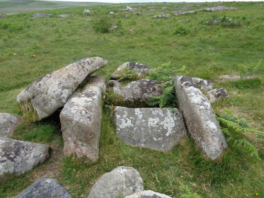
Table of Ritual and Burial Monuments on Hen Tor
The following table lists the records currently in this Guide Map. For an explantion of the Guide Maps and a table of all 62 Guide Maps, follow this link: Guide List Table. Introductory text will be added to each guide list in 2025. Notes on duplication and omissions will appear below the table once checks have been finalised.
Notes on possible duplications and omissions
Willings Walls 7 - a correction My record for MDV103578 (I call it Cairn 7) does not relate to any Butler cairn but is a reported different feature the record having originated from the HER. The attribution of this feature with Butler cairn 4 is a mistake. The grid reference for this entry I had from the HER was SX 58086 65357. Butler cairn 4 is at SX 5830 6535 (butler's grid reference) which is some distance away. Another HER record MDV131161 Cairns on and near Willings Walls reave; possible duplicates correctly describes Cairn 4. So both HER records are required but the first one does not relate to cairn 4. If I'm correct then it is not a duplicate.Hentor Brook 3: Fieldwork is required to determine whether or not there is a cist here as reported by Lethbridge. If there is then it should be added to the HER. Lethbridge reports a possible cist near Willings Walls Reave. There are no entries in the NMR or HER. The NGR is approx SX 5848 6557 - see diagram Discover Prehistoric Dartmoor p.52 (Lethbridge 2015)
PS. These notes are to assist untangling complicated records and are neither permanent nor a criticism of the HER who do a fantastic job! The author finds it easier to systematically work through these records (2000+ of them) and add these notes, which are then to be communicated with the HER, if appropriate, it is a pragmatic way of dealing with lots of data without continually stopping and starting.
Hen Tor Guide Map
Guidance for walkers: The monuments featured in this database are archaeological treasures and need to be protected and preserved - please do not disturb any sites. Please check access and firing times before visiting sites, not all sites listed are on open access land. Firing ranges and boundaries of open access areas are marked on the OL28 OS Dartmoor Explorer map. Please stick to the country code and consider giving support to the numerous agencies that help to keep Dartmoor a fabulous natural and historic environment!
List of Ritual and Burial Monuments on Hen Tor
Ditsworthy Circle Ring Setting Cairn and Cist
OS Map: SX 58342 65726
HER record: MDV42211
Megalithic Portal: 45797
PMD: Ditsworthy Circle
ShortName: CT Ditsworthy
Butler map: 49.6
Grinsell: B:SHE 36
Notes: nb. Not listed by Turner - assigned as "Ring Setting" type cairn due to description in NMR. Butler Vol. 3. Map 49.6. Remains of a ring cairn with three hollows visible within the circle of stones. Two of these probably represent the sites of the two cists recorded by Breton who referred to this cairn as the 'Ditsworthy Circle'. Nothing can be seen of the cists today.
Nearby sites: SX58346573
Hentor Brook 1 Reported Cairn
OS Map: SX 58940 65170
HER record: MDV48946
ShortName: CNxHentor Br 1
Butler map: 49.7
Notes: Hut circle
Nearby sites: SX58946517
Hentor Brook 2 Cairn
OS Map: SX 58410 65580
HER record: MDV55407
ShortName: CN:Hentor Br 2
Nearby sites: SX58416558
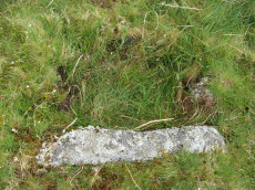
Hentor Brook 3 Reported Cist
OS Map: SX 58480 65570
HER: No record found
ShortName: CT?Hentor Br 3
DPD page: 52
Notes: Lethbridge reports a possible cist near Willings Walls Reave. There are no entries in the NMR or HER. The NGR is approx SX 5848 6557 - see diagram Discover Prehistoric Dartmoor p.52 (Lethbridge 2015)
Nearby sites: SX58486557
Hentor Brook 4 Reported Cist
OS Map: SX 58393 65488
HER record: MDV3480
ShortName: CT?Hentor Br 4
Notes: A cist was alleged at this location but could not be found during field investigation. NOTE: NMR gives NGR of SX58156559, but SX 58393 65488 matches description much better.
Nearby sites: SX58396549
Hentor Brook 5 Reported Cist
OS Map: SX 58500 65600
HER record: MDV22770
ShortName: CT?Hentor Br 5
Notes: SX 58 65 An isolated cist can be found with great difficulty "in the valley of the wallabrook, opposite hentor meadow". The sides have fallen in and the coverstone moved a few feet away (os citing worth)... The cist may be on the west side possibly sx56ne/25. The cist may exist at about sx585656
Nearby sites: SX58506560
Hentor Warren Reported Cist
OS Map: SX 59023 65597
HER: No record found
Alternate name: Hentor Warren 1 Reported Cist
ShortName: CT-HenTorWar 1
Notes: Possible cist reported by Sam Goodwin. This site is close to the ruins of Hentor Warren House. The structure has the appearance of being a Bronze Age site but it is situated in close proximity to a jumble of remains from the historic period including buildings and walls. Site visited by the author and Sam on 16/06/2018. This particular slab has a cavity below it which is large enough for a dog to shelter in. On top of the slab is a thick layer which could represent remains of a cairn.
Nearby sites: SX59026560
Hentor Warren Reported Cist
OS Map: SX 59003 65604
HER: No record found
Alternate name: Hentor Warren 2 Reported Cist
ShortName: CT-HenTorWar 2
Notes: Possible cist reported by Sam Goodwin. This site is close to the ruins of Hentor Warren House. The structure has the appearance of being a Bronze Age site but it is situated in close proximity to a jumble of remains from the historic period including buildings and walls. Site visited by the author and Sam on 16/06/2018.
Nearby sites: SX59006560
Hentor Warren 3 Reported Cist
OS Map: SX 58920 65780
HER record: MDV3504
PMD: Hen Tor Meadow W.
ShortName: CT?HenTorWar 3
Notes: Alledged cist reported by Breton could not be found during field investigation. See als NMR record 438626 and Grinsell SHE 33a
Nearby sites: SX58926578
Hentor Farm Platform Cairn Circle and Cist
OS Map: SX 59089 65792
HER record: MDV12744
Megalithic Portal: 45774
PMD: Hen Tor Meadow
ShortName: CT Hentor Farm
Grinsell: SHA 48
Turner: E45
Notes: "A slight cairn with retaining circle, enclosing a cist aligned SSE-NNW, near the junction of Shavercombe Lake and River Plym." Turner has "central cist". Not listed by Butler (relevant map Vol. 3. Map 49.22).
Nearby sites: SX59096579
Shavercombe Tor 1 Reported Cairn
OS Map: SX 59330 66150
HER record: MDV3349
ShortName: CN:Shavercom 1
Butler map: 49.8.1
Grinsell: SHA 22
Notes: NMR 4 ?
Nearby sites: SX59336615
Shavercombe Tor 2 Reported Cairn
OS Map: SX 59300 66140
HER record: MDV3348
ShortName: CN:Shavercom 2
Butler map: 49.8.2
Grinsell: SHA 21
Notes: NMR 3 ?
Nearby sites: SX59306614
Shavercombe Tor 3 Cairn
OS Map: SX 59260 66130
HER record: MDV55476
ShortName: CN:Shavercom 3
Butler map: 49.8.3
Notes: NMR 2 ?
Nearby sites: SX59266613
Shavercombe Tor 4 Cairn
OS Map: SX 59240 66090
HER record: MDV130770
ShortName: CN:Shavercom 4
Butler map: 49.8.4
Notes: NMR 5 ?
Nearby sites: SX59246609
Shavercombe Tor 5 Cairn
OS Map: SX 59270 66210
HER record: MDV130768
ShortName: CN:Shavercom 5
Butler map: 49.8.5
Notes: HER: Butler records this cairn north-west of Shavercombe Tor (3.0 metres diameter by 0.3 metres high); one of two cairns sited to the north of the later field boundary. Not recorded in 2001-2 survey
Nearby sites: SX59276621
Shavercombe Tor 6 Reported Cairn
OS Map: SX 59230 66190
HER record: MDV55491
ShortName: CN?Shavercom 6
Butler map: 49.8.6
Notes: Hut circle or cairn? NMR 1? Probably HER 55480 - which refers toButler considerig it to be a cairn.
Nearby sites: SX59236619
Shavercombe Enclosed Settlement
OS Map: SX 59366 66297
HER record: MDV3344
Megalithic Portal: 45576
ShortName: ES:Shavercombe
Notes: "Shavercombe pound is not circular. There is no hut circle within the pound. It is one of two main enclosures in a scheduled area which also includes three isolated hut circles. The fence or wall consisted of granite with large stones in the bottom courses. There are many long stones like broad gateposts laid lengthwise along both faces of the wall and filled between in the centre with small stones. The upper part was probably similarly faced with smaller blocks."
Nearby sites: SX59376630
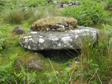
Hentor Cist
OS Map: SX 59252 65720
HER record: MDV55317
Megalithic Portal: 45790
PMD: Hen Tor Warren 1
Alternate name: Hen Tor N.1 Cist
ShortName: CT Hen Tor N 1
Butler map: 49.22.1
DPD page: 51
Notes: Butler Hen Tor 1 (Cairn 1) - Vol. 3. Map 49.22 (general plan of Hen Tor with diagram of cists pp.146-7). "A low earthen barrow or cairn with cist. The barrow is 4m by 3.5m and 0.6m high. The centrally placed cist is 1.2m by 0.75m. internally and 0.2m deep. Three side stones visible, with the cist aligned north-east/south-west, but no coverstone. The overall condition is fair". Lethbridge p.50-51 Shavercombe Cist F - diagram p.49.
Nearby sites: SX59256572
Hentor (Shavercombe) Platform Cairn Circle and Cist
OS Map: SX 59372 65801
HER record: MDV3479
Megalithic Portal: 45661
PMD: Hen Tor Warren 2
Alternate name: Hen Tor N.2 Platform Cairn Circle and Cist
ShortName: CT Hen Tor N 2
Butler map: 49.22.2
DPD page: 50
Grinsell: SHA 26
Turner: E48
Barrow Report: 20
Notes: "A cairn with circle and cist. The cairn is 5m in diameter and 0.4m high and contains at least six upright stones forming a circle that surrounds the centrally placed cist. The cist, in fair condition, is aligned north west/south east. A flat stone lying immediately south west of the cist may be the capstone." Lethbridge p.50-51 Shavercombe Cist E - diagram p.49. Shavercombe. Butler Hen Tor Cairn 2 - Vol. 3. Map 49.22 (general plan of Hen Tor with diagram of cists pp.146-7).
Nearby sites: SX59376580
Hentor B Cist
OS Map: SX 59567 65806
HER record: MDV3490
Megalithic Portal: 45727
PMD: Hen Tor Warren 3
Alternate name: Hen Tor N.3 Cist
ShortName: CT Hen Tor N 3
Butler map: 49.22.3
DPD page: 49
Grinsell: SHA 28
Barrow Report: 52
Notes: "The cairn measures 4.7m in diameter and 0.5m high. The cist, aligned north west to south east, measures 0.8m by 0.4m and is 0.3m deep. A probable coverstone 2.0m to the north measures 0.9m by 0.7m". Lethbridge p.49 Shavercombe Cist B - diagram p.49. Butler Hen Tor 3 (Cairn 3) - Vol. 3. Map 49.22 (general plan of Hen Tor with diagram of cists pp.146-7).
Nearby sites: SX59576581
Hentor Warren (Shavercombe) Platform Cairn Circle and Cist
OS Map: SX 59632 65777
HER record: MDV3492
Megalithic Portal: 45662
PMD: Hen Tor Warren 4
Alternate name: Hen Tor N.4 Platform Cairn Circle and Cist
ShortName: CT Hen Tor N 4
Butler map: 49.22.4
DPD page: 50
Grinsell: SHA 29
Turner: E47
Barrow Report: 12 20
Notes: "On the slope north of Hen Tor at 395.0m OD is the remains of a cairn with a cist. The cairn measures 5.6m in diameter and 0.6m in height with a few stones of a cairn circle 3.2m in diameter remaining on the west side. The cist is 1.2m by 0.4m and 0.5m deep with a coverstone 1.6m by 1.1m at its maximum." Lethbridge p.50 Shavercombe Cist C - diagram p.49. Butler Hen Tor Cairn 4- Vol. 3. Map 49.22 (general plan of Hen Tor with diagram of cists pp.146-7).
Nearby sites: SX59636578
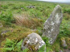
Hentor A Cist
OS Map: SX 59708 65692
HER record: MDV3511
Megalithic Portal: 45712
PMD: Hen Tor Warren 5
Alternate name: Hen Tor N.5 Cist
ShortName: CT:Hen Tor N 5
Butler map: 49.22.5
DPD page: 50
Grinsell: SHA 30
Barrow Report: 52
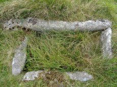
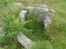
Notes: The author was unable to locate this cist at SX 59708 65692 on 13/08/17. The HER has ngr SX 5971 6570. The site is clearly difficult to find. The area is dense in bracken and according to Lethbridge the cist is very badly damaged. It is unclear how accurate the grid reference is - although it is quite possible that the problem is simply that it is overgrown and difficult to see. A cist consisting of two sidestones, one of which has fallen outwards, and an irregular shaped coverstone. Lethbridge p.50 Shavercombe Cist D - diagram p.49. Butler Hen Tor 5 (Cairn 5) - Vol. 3. Map 49.22 (general plan of Hen Tor with diagram of cists pp.146-7). Update 28/10/25 - the author has been informed by Megalithic Portal user Bladup that the grid reference for this site is correct but the cist can be difficult to see as it is near clitter. For photos uploaded in June 2025 check the MP page linked on this record.
Nearby sites: SX59716569
Hentor (Shavercombe C) Ring Setting Cairn and Cist
OS Map: SX 59606 65893
HER record: MDV3503
Megalithic Portal: 45728
PMD: Hen Tor Warren 6
Alternate name: Hen Tor N.6 Ring Setting Cairn and Cist
ShortName: CT Hen Tor N 6
Butler map: 49.22.6
DPD page: 49
Grinsell: SHA 27
Turner: D14
Barrow Report: 52 56
Notes: "The cairn is 5.2m in diameter and 0.7m high with the remains of a retaining circle. The cist is 1.1m by 0.6m and 0.6m deep with a stone floor; it is aligned north west/south east". Lethbridge p.49 Shavercombe Cist A - diagram 49. Butler Hen Tor 6 (Cairn 6) - Vol. 3. Map 49.22 (general plan of Hen Tor with diagram of cists pp.146-7).
Nearby sites: SX59616589
Hentor (Shavercombe) Cist
OS Map: SX 59825 65892
HER record: MDV3491
Megalithic Portal: 45781
PMD: Shavercombe Brook
Alternate name: Hen Tor N.7 Cist
ShortName: CT Hen Tor N 7
Butler map: 49.22.7
Grinsell: SHA 20
Notes: "The oval cairn is 7.5m by 6.5m and 0.9m high with some kerbing. An amorphous hollow occupies the centre of the mound and a single sidestone of the cist remains in situ". Butler Hen Tor 7 (Cairn 7)- Vol. 3. Map 49.22 (general plan of Hen Tor with diagram of cists pp.146-7).
Nearby sites: SX59836589
Hen Tor N.8 Reported Cairn
OS Map: SX 59490 65810
HER record: MDV55456
ShortName: CN:Hen Tor N 8
Notes: The author of PDW was unable to locate this site at SX 59490 65810 on 13/08/2017. Unable to confirm its existence or non-existence!
Nearby sites: SX59496581
Hen Tor N.9 Cairn
OS Map: SX 59264 65848
HER record: MDV55460
ShortName: CN Hen Tor N 9
Nearby sites: SX59266585
Hen Tor N.10 Reported Cairn
OS Map: SX 59310 65860
HER record: MDV55465
ShortName: CN:Hen Tor N10
Notes: The author of PDW was unable to locate this site at SX 59310 65860 on 13/08/2017. Unable to confirm its existence or non-existence!
Nearby sites: SX59316586
Spanish Lake E Cairn
OS Map: SX 58150 64960
HER record: MDV48896
ShortName: CN:SpanishLake
Butler map: 51.6
Notes: A small cairn on the ridge crest between Spanish Lake and Hen Tor Brook. Apparently undisturbed, it measures 4.0m in diameter and 0.3m high. There is no evidence to suggest the presence of a cist or retaining kerb though some stones do protrude through the turf covering of the mound.
Nearby sites: SX58156496
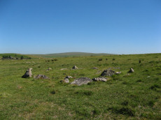
Willings Walls Reave Stone Ring Cairn Circle
OS Map: SX 58220 65200
HER record: MDV56777
Megalithic Portal: 45834
Alternate name: Willings Walls 1 Stone Ring Cairn Circle
ShortName: RC:Willings 1
Butler map: 51.6.1
Turner: A23
Notes: "Ring cairn willings walls reave. Stone ring with internal diam 6.8m, bank 1.5m wide and 0.5m high. Just outside a break in the reave"
Nearby sites: SX58226520

Willings Walls Warren Platform Cairn Circle and Cist
OS Map: SX 58279 65240
HER record: MDV4021
Megalithic Portal: 45711
PMD: Willings Walls Warren S.
Alternate name: Willings Walls 2 Platform Cairn Circle and Cist
ShortName: CT Willings 2
Butler map: 51.6.2
DPD page: 53
Grinsell: SHA 25
Turner: E36
Barrow Report: 51
Notes: "Remains of a kerbed cairn with cist On a slight NW slope near a reave. The cairn is 4.6m in diameter and 0.6m high. Within the outer ring of stones is a second ring of boulders not shown on Worth's plan but which may represent an inner kerb. The cist is 1.8m by 0.9m and 0.5m deep with an adjacent coverstone." Lethbridge p.52-3 Willingswalls Cist 2 (E of Reave) - diagram p52, photo p.53. Butler Willings Walls 2 - Vol. 3. Map 51.6 (diagram p.165).
Nearby sites: SX58286524
Lee Moor (Willings Walls) Cist
OS Map: SX 58278 65339
HER record: MDV4022
Megalithic Portal: 45651
PMD: Willings Walls Warren
Alternate name: Willings Walls 3 Cist
ShortName: CT Willings 3
Butler map: 51.6.3
DPD page: 52
Grinsell: SHA 24
Barrow Report: 19
Notes: "A cairn immediately adjacent to and west of Willings Walls Reave. The cairn mound measures 9 metres in diameter and up to 0.5 metres high. It contains a central cist with one end slab and two side slabs in place". Lethbridge p.52-3 Willingswalls Cist 1 (W of Reave) - diagram p52. Butler Willings Walls 3 (Cairn & Cist 3) - Vol. 3. Map 51.6 (diagram p.166).
Nearby sites: SX58286534
Willings Walls 4 Cairn
OS Map: SX 58300 65350
HER record: MDV131161
ShortName: CN:Willings 4
Butler map: 51.6.4
Grinsell: SHA 24b
Notes: SHA 24a & SHA 24b: NMR record mentions one cairn. The entry for the reave mentions two.
Nearby sites: SX58306535
Willings Walls Warren Stone Ring Cairn Circle
OS Map: SX 58180 65170
HER record: MDV3438
Megalithic Portal: 1358
PMD: Willings Walls Warren Stone Circle
Alternate name: Willings Walls 5 Stone Ring Cairn Circle
ShortName: RC:Willings 5
Turner: A1
Notes: "Willings walls warren, lee moor. Unusual stone circle. Two kists nearby. Plan. A reave interferes with the circumference of the circle. Four groups of stones are in the circle. No trace of barrow within the circle; and no evidence to show that the stones were ever cists (worth)." A 40m diameter circle consisting of 5 groups of stones. It touches and is incorporated into the Willings Walls Reave. Lethbridge p.52-3 Willingswalls Stone Circle - diagram p52.
Nearby sites: SX58186517
Willings Walls 6 Cairn
OS Map: SX 58300 65290
HER record: MDV131336
ShortName: CN:Willings 6
Grinsell: SHA 24a
Notes: Cairns within the reave. SHA 24a & SHA 24b: NMR record mentions one cairn. The entry for the reave mentions two. UPDATE 01/01/2023 This record used to link to the now deleted HER record MDV56774. The HER entry MDV131336 has a similiar description of cairns on the reave but located quite some distance away at SX 58536541. If the grid reference is wrong, it could actually refer to this earlier record from Grinsell. NB. Grinsell refers to a paper by Fleming in 1973.
Nearby sites: SX58306529
Willings Walls 7 Cairn
OS Map: SX 58086 65357
HER record: MDV103578
ShortName: CN:Willings 7
Nearby sites: SX58096536
Willings Walls 8 Reported Cairn
OS Map: SX 58330 65170
HER record: MDV131248
ShortName: CN?Willings 8
Notes: "Two possible stone circles depicted and described by Robertson (1991). Survey in 2002 confirmed that these appear to be natural features. They exist a stony patches on an otherwise stone free north-west facing hillside."
Nearby sites: SX58336517
Eastern Tor Settlement
OS Map: SX 58500 66400
HER record: MDV4023
Megalithic Portal: 19399
ShortName: ST:EasternTor
Nearby sites: SX58506640
Ditsworthy Warren House (NW of) Cairn
OS Map: SX 58142 66361
HER record: MDV4027
Alternate name: Ditsworthy Warren Cairn
ShortName: CN-DitWarrHse
Grinsell: SHE 17
Notes: Its base is partially turf-covered and it may be a clearance cairn lying upon an older feature.
Nearby sites: SX58146636
Willings Wall Enclosure 'E' Clearance Cairn
OS Map: SX 57840 65800
HER record: MDV126872
Alternate name: Willings Wall Enclosure 'E' Clearance Cairn
ShortName: CN?WillingsEnc
Grinsell: SHA 23
Notes: Two clearance cairns associated with hut circles within Enclosure 'E' (Butler) at Willings Walls Warren and relate to the medieval or later reuse of the site.
Nearby sites: SX57846580
A Breton Special Reported Cist
OS Map: SX 59000 66000
HER: No record found
PMD: A Breton Special
ShortName: CT?BretonSpec
Notes: This is not possible to trace. Radcliffe notes: Could be any one of the cists in the area. The information is from Breton in OS map collection. NMR suggest SX 56 NE 44, 5909 6577? Possibly the 5947 6674 site? Could be Hentor Warren 3
Nearby sites: SX59006600
Hen Tor Cairn
OS Map: SX 59330 65910
HER record: MDV55466
ShortName: CN:HenTor
Notes: HER: Cairn lying within an historic field. Forms part of a complex multi period archaeological landscape on the north-west slope of Hen Tor overlooking the valley of the River Plym. Mound is 3m in diameter and stands up to 0.4m high.
Nearby sites: SX59336591
Hen Tor Cairnfield Master
OS Map: SX 59230 65870
HER record: MDV55459
ShortName: CN:HenTorM
Notes: HER: A cluster of mounds within an historic field was identified by Gerrard in 1995. Forms part of a complex multi-period archaeological landscape on the north-west slope of Hen Tor overlooking the valley of the River Plym. Not noted in 2002 survey.
Nearby sites: SX59236587
Hentor Warren Cairn
OS Map: SX 59300 66140
HER record: MDV14625
ShortName: CN:HenTorWar 4
Notes: HER: Within the vicinity of these traps are two small stony mounds. The first lies 4m east-north-east of the northern trap and survives as a 1m diameter and 0.1m high mound. The second lies a further 14m to the east-north-east and is 2m in diameter and 0.2m high. A number of edge set stones around the periphery of this mound may indicate the presence of a kerb.
Nearby sites: SX59306614
Shavercombe Cairn
OS Map: SX 59310 66110
HER record: MDV129291
ShortName: CN:Shaver
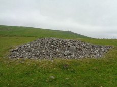
Notes: HER: A small disturbed cairn measuring 3.5m north-south by 3.8m and 0.3m high. The centre of this feature has been removed and deposited to the east.
None of the cairns display any evidence of cists or kerbs.
Nearby sites: SX59316611
Page last updated 10/12/24