
Guide to the Monuments on Upper Erme
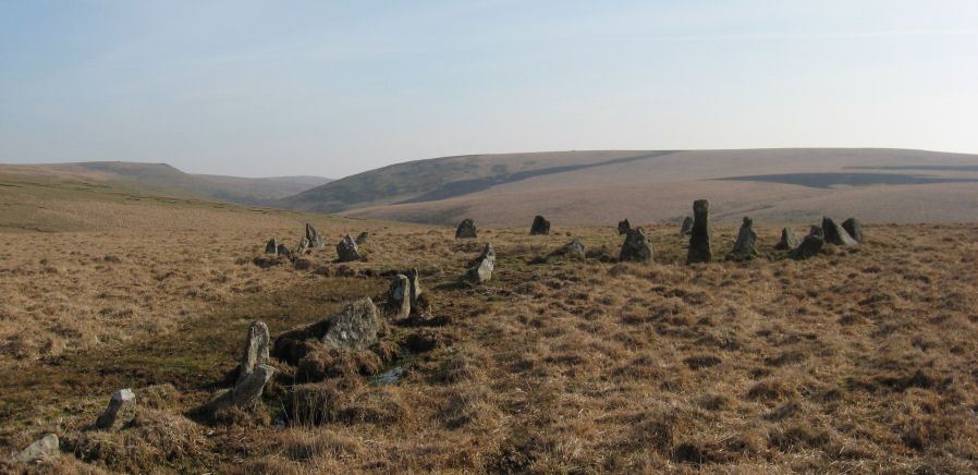
Table of Ritual and Burial Monuments on Upper Erme
The following table lists the records currently in this Guide Map. For an explantion of the Guide Maps and a table of all 62 Guide Maps, follow this link: Guide List Table. Introductory text will be added to each guide list in 2025. Notes on duplication and omissions will appear below the table once checks have been finalised.
Notes on possible duplications and omissions
Stallmoor and greenhill stone row HER entry MDV5104 - quote Same as 4309?. Yes, it is a duplicate of HER4309.Knackersmill Gulf N. Cist The HER entry MDV28468 is a duplicate of MDV13185. Bothe refer to a cist on Kanackesmill Gulf with close grid references both a 4m cairn with a 1.2m cist.
PS. These notes are to assist untangling complicated records and are neither permanent nor a criticism of the HER who do a fantastic job! The author finds it easier to systematically work through these records (2000+ of them) and add these notes, which are then to be communicated with the HER, if appropriate, it is a pragmatic way of dealing with lots of data without continually stopping and starting.
Upper Erme Guide Map
Guidance for walkers: The monuments featured in this database are archaeological treasures and need to be protected and preserved - please do not disturb any sites. Please check access and firing times before visiting sites, not all sites listed are on open access land. Firing ranges and boundaries of open access areas are marked on the OL28 OS Dartmoor Explorer map. Please stick to the country code and consider giving support to the numerous agencies that help to keep Dartmoor a fabulous natural and historic environment!
List of Ritual and Burial Monuments on Upper Erme
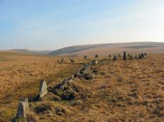
Stall Moor (Upper Erme) Stone Row
OS Map: SX 63663 67796
HER record: MDV4309
Megalithic Portal: 1464
The Stone Rows of GB: Upper Erme
PMD: Stall Moor Stone Row
Alternate name: Upper Erme Row Stone Row
ShortName: SR Stall Moor
Butler map: 55.7
DPD page: 71
Notes: Worth: Stall Moor. Butler: Upper Erme. The longest stone row on Dartmoor. "A single stone row running for approximately 3.1km from a cairn on Green Hill to a stone circle on Stall Moor". Lethbridge pp.71-72, diagram p.71
Nearby sites: SX63666780
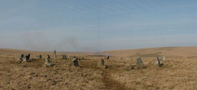
Erme Cairn Circle
OS Map: SX 63517 64442
HER record: MDV4310
Megalithic Portal: 533
Alternate name: Upper Erme stone row Cairn Circle
ShortName: CC The Dancers
Butler map: 55.7.1
DPD page: 71
Grinsell: COR 10
Turner: G16
Notes: An impressive cairn circle (often referred to as a stone circle) on Stall Moor which is also known as The Dancers, Kiss in the Ring or Stall Moor Circle. "Round barrow with retaining circle at south end of longest Dartmoor stone row. Diameter 16m, height of mound 0.3m." Lethbridge pp.70-71, diagram p.71
Nearby sites: SX63526444
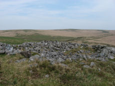
Green Hill Cairn
OS Map: SX 63665 67796
HER record: MDV5106
Megalithic Portal: 2143
PMD: Green Hill
ShortName: CN GreenHill
Butler map: 55.7.4
DPD page: 72
Grinsell: LYD 101
Barrow Report: 14
Notes: "Cairn on the summit of Green Hill is the northern terminal of the stone row (SX 66 NW 20 but see also SX 66 NW 101 for cairn which may extend the row). Diameter 9m, height 0.7m. The possible remains of a central cist are indicated by a group of large stone slabs".
Nearby sites: SX63676780
Green Hill Clearance Cairn
OS Map: SX 63650 67740
HER record: MDV28465
ShortName: CN?GreenHill2
Grinsell: B:LYD 101b
Notes: Mound 30m S of LYD 101 period doubtful. A cairn was alleged on Green Hill but field evidence revealed a small mound measuring 7.8m by 7.5m and 0.4m high and concluded that it is the remains of peat workings.
Nearby sites: SX63656774
Green Hill N.W. Cairn
OS Map: SX 63290 68290
HER record: MDV128573
ShortName: CN:GreenHillNW
Notes: HER (Greeves): Probable barrow at SX6328868297 on north-west flank of Green Hill. A discrete and seemingly undisturbed circular mound at SX6328868287 is probably a prehistoric barrow of approximately 8 metres in diameter by 1 metre high. No stones visible. The feature is on the extreme north-west flank of Green Hill on the south side and overlooking a tributary of the Blacklane Brook at a height of 457 metres OD.
Nearby sites: SX63296829
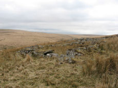
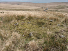
Upper Erme Cairn
OS Map: SX 63522 64958
HER record: MDV4366
Megalithic Portal: 15210
Alternate name: Erme Plains Cairn
ShortName: CN Upper Erme
Butler map: 55.7.2
Grinsell: COR 9
Notes: "A round cairn, measuring 13.8 to 14.6m diameter and 1.0m high. It lies on a false crest, adjacent to a stone row, SX 66 NW 20, and just above the River Erme, at 380m above OD, is constructed of small boulders, and has a central hollow, 0.7m deep. In fair condition, though a small shelter has been built on its north side." The photo used here was taken in 2011 and attached to this record retrospectively in 2020 - identification is most probable but not 100% certain.
Nearby sites: SX63526496
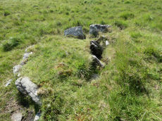
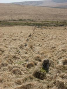
Knackersmill Gulf N. Cist
OS Map: SX 63390 65587
HER record: MDV13185
Megalithic Portal: 45759
PMD: Stinger's Hill
ShortName: CT Stingers
Butler Vol 5: p.180 & Fig.122
DPD page: 73
Grinsell: COR 8
Notes: The NMR gives SX63376494 as the grid reference - this error is replicated in HER entry 28468. The author could not find a cist there. As PMD points out that is the location of Grinsell's CORNWOOD 9 cairn and not CORNWOOD 8. "A cist 1.20m. by 0.60m. with a close set retaining kerb circle 4.0m. in diameter is situated on Stinger's Hill opposite Erme Pound". Lethbridge Stingers Hill cist p.73. diagram p.71. Butler Map 55.7. (diagram Vol. 5. p.180). The author visited this site on 16/7/21 and the grid reference is confirmed as listed on this record.
Nearby sites: SX63396559
Knackersmill Gulf N. (duplicate) Reported Cist
OS Map: SX 63370 65590
HER record: MDV28468
Megalithic Portal: 45759
ShortName: CT:Stingers 2
Butler Vol 5: p.180 & Fig.122
Notes: Duplicate of HER 13185, see notes on PMD on this.
Nearby sites: SX63376559
Knackersmill Gulf C, wall cairn 10 (55.3) Reported Cairn
OS Map: SX 63700 65000
HER record: MDV13172
ShortName: CN?Knackersm
Butler Vol 5: p.102 & Fig.60
Notes: Estimated grid ref from Butler. This is a structure embedded into a settlemnt enclosure wall. Could be a hut circle that has been filled in or converted to a cairn.
Nearby sites: SX63706500
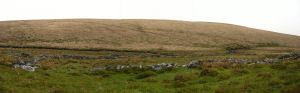
Brown Heath Enclosed Settlement
OS Map: SX 64080 65389
HER record: MDV5135
Megalithic Portal: 14936
ShortName: ES Brown Heath
DPD page: 74
Barrow Report: 38
Notes: "A fine example of an enclosure. The walling consisting of very large stones reaching a height of one metre. It contains three hut circles and a number of courts situated mainly on its north and western sides. There is no obvious entrance." Lethbridge p. 74, diagram p.71. Hook Lake on Megalithic Portal.
Nearby sites: SX64086539
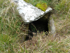
Redlake Foot (Brown Heath) Cist
OS Map: SX 63778 66069
HER record: MDV5102
Megalithic Portal: 45760
PMD: Brown Heath
Alternate name: Brown Heath Cist
ShortName: CT Brown Heath
Butler map: 55.7.3
DPD page: 73
Grinsell: HAR 1
Barrow Report: 60 69 71
Notes: "A fine cist at Redlake Foot measuring internally, 0.7m. by 1.0m. and 1.0m. deep single slabs form the end-stones and the southern side-stone. The northern side is a slab resting on a horizontal 'post' type stone" Cover slab partly displaced from the sides. Lethbridge p.73, diagram p.71. Butler Brown Heath (Cairn 3) - Vol. 4. Map 55.7.3 (p.76-7 diagram p.76).
Nearby sites: SX63786607
Brown Heath (Hook Lake) Stone Row
OS Map: SX 64112 65318
HER record: MDV5136
Megalithic Portal: 1788
The Stone Rows of GB: Hook Lake
PMD: Brown Heath Stone Row
Alternate name: Hook Lake Stone Row
ShortName: SR Hook Lake
Butler map: 55.8
DPD page: 74
Barrow Report: 38
Notes: Worth: Brown Heath, Butler: Hook Lake. "On the southwest slopes of Brown Heath a double stone row 182.0m. long runs from a cairn circle at its northern and higher end to the east side of the enclosure (SX 66 NW 50) where it is overlaid by the enclosure wall. The point at which the southern end of the row ended is therefore not easily determined. The row does not point exactly to the centre of the cairn, but to about 2.0m. to the East. The eastern part of the row contains more stones than the western part, in which there are notable gaps. There are a few large stones, the largest being 1.0m. high and measuring 1.0m. x 0.7m., but most are relatively small, their average height being 0.5m". Lethbridge p.74, diagram p.71. See also: Sea Views at Hook Lake/
Nearby sites: SX64116532
Brown Heath (Hook Lake) Encircled Cairn and Cist
OS Map: SX 64114 65327
HER record: MDV5137
Megalithic Portal: 52166
The Stone Rows of GB: Hook Lake
PMD: Hook Lake Stone row
Alternate name: Hook Lake stone row Encircled Cairn and Cist
ShortName: CT Hook Lake
Butler map: 55.8
DPD page: 74
Grinsell: HAR 3
Turner: F11
Barrow Report: 38
Notes: "A double stone row, on Brown Heath, circa 540 feet in length, direction of length N 10o E. At the north end is a stone circle, diameter 31 feet, surrounding a cairn which contains the remains of a cist." Ruined and possibly no longer visible. Butler Hook Lake stone row - Vol. 4. Map 55.8 (pp.78-9).
Nearby sites: SX64116533
Erme Pound
OS Map: SX 63800 65800
HER record: MDV5109
Megalithic Portal: 14937
ShortName: PD Erme Pound
DPD page: 71
Notes: See also MDV5110
Nearby sites: SX63806580
Erme Pound (Near) Cist
OS Map: SX 63920 65510
HER record: MDV28585
Megalithic Portal: 45758
PMD: Erme Pound
ShortName: CT:Erme Pound
Grinsell: HAR 2
Turner: D29
Notes: "A prehistoric round cairn, 300 metres west of the River Erme in an area of intense peat cutting remains. The cairn has surviving elements of a kerb and a central hollow which may have contained a cist. This probable platform cairn has a diameter of 3.8 metres and is raised above ground by 0.5 metres. The flat-topped mound is surrounded by a closely fitting, though incomplete, kerb of upright slabs, where many of the survivors remain in situ. An elongated hollow across the centre of the cairn may represent a disturbed cist, and a displaced slab within the hollow is the remains of a capstone.". "Noted by Hankin in July 1976, perhaps in a small cairn diameter 3.7m and height 0.3m. It is now filled in and Grinsell failed to locate it, 'it seems never to have been planned if it ever existed.'" This cist was listed by Dixon in 1952 70th Barrow Report (T.D.A Vol 84) with Dixon #96. It is not listed in prior Barrow Reports - and appears towards end of Dixon's list, so presumably discovered/reported late 40s to 1952. Not listed by Butler (area covered in Vol. 4. Map 55). Not listed in Hankin's 'An archaeological check-list for Harford'.
Nearby sites: SX63926551
Page last updated 10/12/24