
Listing of Dartmoor Neolithic Sites

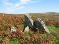
Photo: Corringdon Ball Chambered Tomb
Chambered Tombs
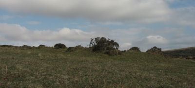
Butterdon Hill Chambered Tomb
Prehistoric Dartmoor Walks: Dartmoor Walk: The Neolithic tombs of Cuckoo Ball & Corringdon Ball
OS Map: SX 66012 58573
HER: MDV2886
Megalithic Portal: 31698
PMD: Butterdon Long Cairn
Alternate name: Butterdon Hill chambered cairn Chambered Tomb
Short Name: NT Butterdon
Butler map: 53.15
Butler Vol 5: p.155
Grinsell: A:UGB 2
Dimensions (m): 25.0 x 13.0 x 0.9
Notes: "The mound is situated on a slight south-east slope at 1050 ft O.D. It is 25 metres long, orientated north-south, is 16.0 metres wide and 0.9 metre high at the north end and 10.0 metres wide and 0.7 metre high at the south end. There are no visible side ditches. The construction is of earth and small stones but extensive pillaging and/or excavation has exposed a number of large upright and some displaced stones. The mound is certainly a long barrow."
Nearest Bus Stop: Ivybridge BP Garage (Stop B) (3.4 km) [Route: 38]
Nearby sites: SX 66012 58573
Gidleigh - South Chambered Tomb
OS Map: SX 6567 8855
HER: MDV6213
Megalithic Portal: 10040
PMD: Gidleigh South Chambered Cairn
Alternate name: Buttern Hill 1 Chambered Tomb
Short Name: NT Gidleigh S
Butler map: 38.7.1
Butler Vol 5: p.157
DPD: 147
Dimensions (m): 8.0 x 6.0 x 0.5
Notes: "The remains of a Neolithic chambered cairn on Buttern Hill. The cairn survives as a mound standing up to 0.6 metres high. The chamber and associated entrance passage include seven orthostats, two of which form a portaled entrance. A leat runs to the west of the cairn."
Nearest Bus Stop (Minor): Wonson Telephone Box (2.0 km) [Route: 670]
Nearest Bus Stop (Major): Chagford The Square (4.5 km) [Route: 173,178,671]
Nearby sites: SX 6567 8855
Gidleigh - North Chambered Tomb
OS Map: SX 65867 88956
HER: MDV6212
Megalithic Portal: 45581
PMD: Gidleigh North Chambered Cairn
Alternate name: Buttern Hill 2 Chambered Tomb
Short Name: NT Gidleigh N
Butler map: 38.7.2
Butler Vol 5: p.157
Grinsell: A:GID 1
Notes: "A chambered cairn located on an east facing slope of Buttern Hill. The cairn mound measures 26 metres long and 9 metres wide and stands up to 1 metre high. Several set stones at the western end of the mound represent the remains of a passage leading towards a chamber."
Nearest Bus Stop (Minor): Wonson Telephone Box (1.6 km) [Route: 670]
Nearest Bus Stop (Major): Ramsley (4.4 km) [Route: 670,671,6A]
Nearby sites: SX 65867 88956

Gidleigh - South 2 Chambered Cairn
OS Map: SX 65534 88378
HER: MDV20318
Alternate name: Buttern Hill 3 Chambered Cairn
Short Name: NT Gidleigh S2
Dimensions (m): 14 x 5.8 x 0.9
Notes: HER quoting Turner: Possible chambered cairn recorded at SX 6554 8837 on Gidleigh Common. A simple chamber cairn with evidence of a chamber (two fallen large stones at south, south-west end). Although many large boulders still remain in position, cairn has obviously been heavily robbed for later enclosure lying to the north.
Measurements: length 15.5m, width 3.5 to 5.5m, height 0.8m. This features differs from the other Gidleigh chamber tombs (North and South) as there is no evidence for a passage. It appears to be on the same axis and similar to the Corringdon ball example. Orientation south, south-west by north, north-east.
Nearest Bus Stop (Minor): Wonson Telephone Box (2.2 km) [Route: 670]
Nearest Bus Stop (Major): Chagford The Square (4.6 km) [Route: 173,178,671]
Nearby sites: SX 65534 88378
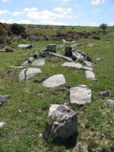
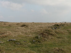
Corringdon Ball Chambered Tomb
Prehistoric Dartmoor Walks: Dartmoor Site: Corringdon Ball Chambered Tomb & Stone Rows
OS Map: SX 66956 61300
HER: MDV5750
Megalithic Portal: 4619
PMD: Corringdon Ball Chambered Cairn
Alternate name: Corringdon Ball chambered tomb Chambered Tomb
Short Name: NT Corringdon
Butler map: 56.10
Butler Vol 5: p.155
Dixon Cist #: 26
Grinsell: A:BRE 1
DPD: 83
Barrow Report: 28 56 66
Dimensions (m): 42 x 18 x 2.4
Notes: "An earthen long barrow with a ruined stone chamber at the south east end. Early excavation and mutilation has resulted in two distinct mounds, the larger one at the south east end separated from the smaller by a path or trackway. The smaller mound appears to mark the limit of the barrow on the northwest; beyond this it merges into the natural hill-side. There are no side ditches but these may be obscured by soil washed down from the hill. The length is 42.0 m; the maximum width is 18.0m and the maximum height of 2.4m."
Nearest Bus Stop: South Brent Pool Park (3.5 km) [Route: 38]
Nearby sites: SX 66956 61300
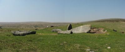
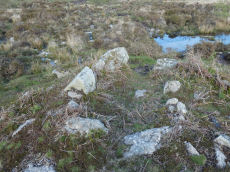
Cuckoo Ball Chambered Tomb
Prehistoric Dartmoor Walks: Dartmoor Site: Cuckoo Ball Chambered Tomb
OS Map: SX 65963 58195
HER: MDV2885
Megalithic Portal: 31700
PMD: Cuckoo Ball Chambered Cairn
Alternate name: Cuckoo Ball chambered cairn Chambered Tomb
Short Name: NT Cuckoo Ball
Butler map: 53.15
Butler Vol 5: p.155
Dixon Cist #: 29
Grinsell: A:UGB 1
DPD: 80
Barrow Report: 30 56
Dimensions (m): c.28.0 x 12.0 x 0.8
Notes: "The remains of a long cairn and burial chamber on a hill-slope at Cuckoo Ball. The cairn, which was probably robbed for newtake walls to the west and north, is 23 metres long by 12 metres wide, aligned north/south, and is 0.7 metre high at the north. The burial chamber is at the north end."
Nearest Bus Stop: Ivybridge BP Garage (Stop B) (3.1 km) [Route: 38]
Nearby sites: SX 65963 58195
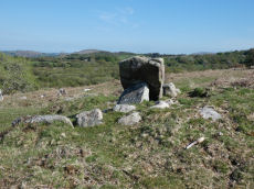
Haytor Chambered Tomb
OS Map: SX 75766 76409
HER: MDV61778
Short Name: CN HaytorTomb
Butler map: 1.f
Butler Vol 5: p.158 & Fig.97
Dimensions (m): c.3.0 x 1.4 wide
Notes: Haytor chambered tomb to the west of the Haytor track. Circular mound circa 4 metres diameter surrounds a rectangular chamber, circa 3 metres by 1.4 metres, tapering slightly towards one end, partially filled with soil. One of pair of larger slabs at entrance on downhill edge of mound has collapsed inwards, the other stands c irca 1 metre above interior. Most of slabs forming sides of chamber appear in place but capstones have been removed. Entrance oriented south of east.
Nearest Bus Stop (Minor): Haytor Vale Moorlands House (1.3 km) [Route: 193,271]
Nearest Bus Stop (Major): Lemonford Caravan Park (5.3 km) [Route: 38,193]
Nearby sites: SX 75766 76409
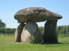
Spinsters Rock Chambered Tomb
Prehistoric Dartmoor Walks: Dartmoor Site: Spinsters' Rock
OS Map: SX 70098 90789
HER: MDV8440
Megalithic Portal: 149
PMD: Spinsters Rock
Short Name: NT Spinsters
Butler Vol 5: p.155
Grinsell: A:DREW 1
DPD: 150
Barrow Report: 56
Notes: Chambered tomb restored in 1862. No evidence to confirm or deny the existence of an original mound survives. The remains of the chamber consist of three granite orthostats 6 to 9 1/2 feet high which support a large capstone 14 1/2 feet long by 10 feet wide. No trace of any mound survives. It is associated with the nearby stones thought to have been circles and alignments (SX 69 SE 25) (see Shilstone Common & Spinster's Rock page).
Nearest Bus Stop: Chagford Sandy Park Inn (1.6 km) [Route: 173,178,671]
Nearby sites: SX 70098 90789
Neolithic Enclosures
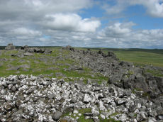
White Tor (Whittor) Neolithic Enclosure
Prehistoric Dartmoor Walks: Dartmoor Site: White Tor Fort
OS Map: SX 5423 7867
HER: MDV4101
Megalithic Portal: 17506
Short Name: NE White Tor
Butler map: 31.13
DPD: 13
Notes: Neolithic tor enclosure. "A camp on the summit of White Tor formed by a double wall, now in ruinous condition. Both walls appear to have been 10 to 11 feet thick, the outer wall being 4 to 4 1/2 feet high, the inner 6 to 7 feet high. The distance between the walls varies between 10 and 40 feet. The entrances are to the east, where access is easier, they are not opposite and are protected by the spur walls. Within the camp are four hut circles and three possible hut shelters, and two northern circles (numbers 5 and 6 on plan) are joined by a short wall." See also, Legendary Dartmoor: Dartmoor's White Tor Neolithic Settlement. See also Dartmoor Tor Enclosures Project.
Nearest Bus Stop: Merrivale Dartmoor Inn (3.6 km) [Route: 98,171,172]
Nearby sites: SX 5423 7867
Dewerstone Neolithic Enclosure
OS Map: SX 538 639
HER: MDV2380
Megalithic Portal: 29453
Short Name: NE:Dewerstone
Butler map: 48.1
Notes: A poorly preserved stone-built double walled enclosure, the outer of which is thought to represent the site of a Neolithic hilltop enclosure. "The outer enclosure is potentially Neolithic, while the inner is probably of Bronze Age date. The stone-built double wall of the outer enclosure is poorly preserved with an average height of 0.7m, and given its loose composition is unlikely to have stood higher than 1.5m. The inner and outer walls now have average widths of 4.0m and 3.4m respectively. Five probable or possible entrances through the double wall were identified; the existence of so many may support the hypothesis that the enclosure is of Neolithic date." See also Dartmoor Tor Enclosures Project.
Nearest Bus Stop: Shaugh Prior Shaugh Bridge (0.6 km) [Route: 59]
Nearby sites: SX 538 639
Upper Glazebrook Neolithic Enclosure
Prehistoric Dartmoor Walks: Dartmoor Site: Corringdon Ball Chambered Tomb & Stone Rows
OS Map: SX 6636 6126
HER: MDV5692
Megalithic Portal: 45594
Short Name: NE Upper Glaze
Butler Vol 5: p.155
Notes: A rectangular enclosure not far from Corringdon Ball chambered tomb measuring 112m by 34m that can be seen clearly on aerial and satellite photos of the area. The walls are up to 1.5m thick and 0.3m high, and have been entirely destroyed on the east and north-west sides. There is no obvious entrance and the interior is empty of any structure. According to Butler the east to west orientation of the long axis could suggest a mortuary enclosure of mid-neolithic date (Vol 5 pp.155-6).
Nearest Bus Stop: South Brent Pool Park (4.1 km) [Route: 38]
Nearby sites: SX 6636 6126