
Prehistoric sites within 2km of SX 54510 69120
Guidance for walkers: The monuments featured in this database are archaeological treasures and need to be protected and preserved - please do not disturb any sites. Please check access and firing times before visiting sites, not all sites listed are on open access land. Firing ranges and boundaries of open access areas are marked on the OL28 OS Dartmoor Explorer map. Please stick to the country code and consider giving support to the numerous agencies that help to keep Dartmoor a fabulous natural and historic environment!
About the database listings: In all listings clicking on the photo or the site name will open a page for the site with a larger photo and further details from the database. The database now has over 6680 records covering nearly all publicly listed sites on Dartmoor including around 4800 round houses. This level of detail is of interest to archaeologists but tends to swamp listings of sites more likely to be of interest for walkers. For this reason, the listings default to around 550 core sites only. These are the stone circles, stone rows and the ring cairns listed by Turner. The default search radius is 2 km. The controls below the map can be used to start a new search by entering a 6- or 8-digit reference (without the prefix "SX"). The search radius can be specified and you can add incremental Display layers of detail on top of the core sites. If using a more detailed layer you will need to decrease the search radius to avoid getting hundreds of search results.
- Core sites Default listing of core sites consisting of stone circles & rows and some of the major ring cairns.
- Plus cairns adds approx. 1000 cairns and other minor sites not included in the core listings but excluding round houses.
- Plus round houses adds approx. 4800 round houses.
- Plus non-sites adds in the records for sites that no longer exist or are not prehistoric sites.
- Plus duplicates adds records excluded as duplicates. Those maybe duplicate records in external listings (e.g. the Historic Environment Records). For example, some sites have been identified as cairns in some listings and interpreted as round houses in other listings and both records appear.
These listings have incorporated, matched up and merged all of the records from all of the major archaeological listings including: Worth, Grinsell, Turner, Butler, Bill Radcliffe, Sandy Gerrard, Megalithic Portal, the National Monument Records and the Historic Environment Records. The author would like to thank Bill, Sandy, the lovely people both at Megalithic Portal (especially Anne Tate who did an amazing job to link listings) and at ACE Archaeology for collaborative work over the years to synchronise and correct listings across the various websites which now interlink. A culmination of years of work the final merger of cairn records took 3 months of cross referencing in 2017 the result being a snapshot of the records at that time. This data has in turn been refined since by field work and research. The round house data was supplied by Sandy Gerrard. Grid references are in order of accuracy: from Google Earth satellite, if visible and found, from a Garmin GPS reading, if visited by the author and from the literature otherwise. Individual site pages will state the source of the grid reference and provide satellite imagery. If a site listing lacks a photo it has not yet been visited by the author in which case the grid reference is from the literature.
Currently the database only includes sites which can be represented by a grid reference. Reaves are not included as they require GIS shape technology which is beyond the current capability of this system. To see the sources for the records, look at the tables on the resources menu. The database listings can also be viewed on a Google map and downloaded as GPS datasets for Garmin devices.
Corrections, or any feedback or suggestions are very welcome, email: info@dartmoorwalks.org.uk.
NOTE: Clicking on the icons for each monument in the map will give the name of the site. You can zoom in and out and drag the map around.
List of sites within 2km of SX 54510 69120

Goadstone Pond Ancient Pool
OS Map: SX 55706 70663
HER: MDV28232
ShortName: PO GoadsStone
Notes: "Pool on the summit of the hill near a stone row. Some of the stones from the double stone row appear to have been lost in the pool. Previously incorrectly identified from aerial photograph as an enclosure. One of over 40 pools on Dartmoor thought to have originated in the Prehistoric period."
Worth and Butler refer to this as Goatstone Pool. There is a very interesting discussion of both the origin of the name and of the cairns and stone rows on DartmoorCam: Sharpitor. See also Legendary Dartmoor: Dartmoor's Goadstone
Nearby sites: SX 55706 70663
Distance: 1.95km
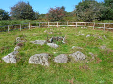
Leather Tor Platform Cairn Circle and Cist
OS Map: SX 56325 69524
HER: MDV3434
Megalithic Portal: 34457
PMD: Cross Gate
Alternate name: Leather Tor S. Platform Cairn Circle and Cist
ShortName: CT Leather Tor
Butler map: 45.17
DPD page: 23
Grinsell: WAL 25
Turner: E20
Barrow Report: 54
Notes: "A cist, consisting of two side stones and an end stone, contained within a barrow surrounded by a 16ft 6 ins diameter Kerb circle." Butler Leather Tor S. - Vol. 3. Map 45.17 (diagram p.52).
Nearby sites: SX 56325 69524
Distance: 1.86km
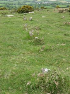
Sharpitor N.W. 1 Stone Row
Prehistoric Dartmoor Walks: Dartmoor Walk: Sharpitor area Stone Rows and Cists
OS Map: SX 55665 70617
HER: MDV3762
Megalithic Portal: 2118
The Stone Rows of GB: Sharpitor North West 1
PMD: Sharpitor Summit N Stone Row
Alternate name: Sharpitor NW 1 Stone Row
ShortName: SR Sharp NW1
Butler map: 45.12.1
DPD page: 21
Barrow Report: 66
Notes: "The double stone row is in poor shape. Both terminals have survived fixing its length at 113m from the blocking stone to the centre of the cairn. The cairn (4.5 x 0.3) has lost its retaining circle and has been dug into in the centre. The other end of the row is well defined by a pair of larger slabs in the line of the rows followed by a central cross-set blocking stone 1.2m long that has been tipped backwards and is partly overgrown. The stones seemed to have increased in size nearer the cairn. Unusually the highest point on the ground is not at the cairn end but near the centre of the rows as they cross the summit of the ridge".
Nearby sites: SX 55665 70617
Distance: 1.89km

Sharpitor N.W. 2 Stone Row
Prehistoric Dartmoor Walks: Dartmoor Walk: Sharpitor area Stone Rows and Cists
OS Map: SX 55687 70600
HER: MDV3761
Megalithic Portal: 2119
The Stone Rows of GB: Sharpitor North West 2
PMD: Sharpitor Summit S Stone Row
Alternate name: Sharpitor NW 2 Stone Row
ShortName: SR Sharp NW2
Butler map: 45.12.2
DPD page: 21
Notes: "A BA single stone row oriented NE - SW at a very slight angle to the north-east end of the adjacent double stone row. The large scale survey dated 1980 shows a total of thirty stones whilst in 1994 it was reported that only about 10 stones can be identified with certainty and half of these are either buried or just showing."
Nearby sites: SX 55687 70600
Distance: 1.89km
Sharpitor W. (Peek Hill) Cairn Circle
Prehistoric Dartmoor Walks: Dartmoor Walk: Sharpitor area Stone Rows and Cists
OS Map: SX 55056 70751
HER: MDV5011
Megalithic Portal: 52566
PMD: Sharpitor W Stone Row
Alternate name: Sharpitor W. stone row Cairn Circle
ShortName: CC Sharpitor W
Butler map: 45.11
DPD page: 20
Grinsell: WAL 18
Notes: "The cairn lies on a gentle sw slope ne of horseyeatt farm, with a stone row see sx57se/141 running sw from it. The cairn is about 7m in diameter and 0.6m height, partly turf-covered, with a central hollow. The visible set stones within the cairn suggest two or three underlying concentric stone circles. These stones have a maximum height of 0.2m and are predominantly set with their long axes tangential to the circle". Lethbridge pp.19-20, diagram p.19.
Nearby sites: SX 55056 70751
Distance: 1.72km
Sharpitor W. (Peek Hill) Stone Row
Prehistoric Dartmoor Walks: Dartmoor Walk: Sharpitor area Stone Rows and Cists
OS Map: SX 55058 70748
HER: MDV12831
Megalithic Portal: 2120
The Stone Rows of GB: Sharpitor West
PMD: Sharpitor W Stone Row
Alternate name: Sharpitor W Stone Row
ShortName: SR Sharpitor W
Butler map: 45.11
DPD page: 20
Notes: Butler: Sharpitor W, Worth: Peek Hill. Near Horseyeat Farm. "BA stone row and cairn. The 132m long row has 47 upright stones and the low cairn is 8.4m in diameter. Both monuments lie under dense bracken cover; gorse vegetation has obscured part of the row". Lethbridge pp.19-20, diagram p.19, photo p.20 Horseyeat Farm stone row. See also: Sea Views at Sharpitor West
Nearby sites: SX 55058 70748
Distance: 1.72km