
Prehistoric sites within 2km of SX 65390 80600
Guidance for walkers: The monuments featured in this database are archaeological treasures and need to be protected and preserved - please do not disturb any sites. Please check access and firing times before visiting sites, not all sites listed are on open access land. Firing ranges and boundaries of open access areas are marked on the OL28 OS Dartmoor Explorer map. Please stick to the country code and consider giving support to the numerous agencies that help to keep Dartmoor a fabulous natural and historic environment!
About the database listings: In all listings clicking on the photo or the site name will open a page for the site with a larger photo and further details from the database. The database now has over 6680 records covering nearly all publicly listed sites on Dartmoor including around 4800 round houses. This level of detail is of interest to archaeologists but tends to swamp listings of sites more likely to be of interest for walkers. For this reason, the listings default to around 550 core sites only. These are the stone circles, stone rows and the ring cairns listed by Turner. The default search radius is 2 km. The controls below the map can be used to start a new search by entering a 6- or 8-digit reference (without the prefix "SX"). The search radius can be specified and you can add incremental Display layers of detail on top of the core sites. If using a more detailed layer you will need to decrease the search radius to avoid getting hundreds of search results.
- Core sites Default listing of core sites consisting of stone circles & rows and some of the major ring cairns.
- Plus cairns adds approx. 1000 cairns and other minor sites not included in the core listings but excluding round houses.
- Plus round houses adds approx. 4800 round houses.
- Plus non-sites adds in the records for sites that no longer exist or are not prehistoric sites.
- Plus duplicates adds records excluded as duplicates. Those maybe duplicate records in external listings (e.g. the Historic Environment Records). For example, some sites have been identified as cairns in some listings and interpreted as round houses in other listings and both records appear.
These listings have incorporated, matched up and merged all of the records from all of the major archaeological listings including: Worth, Grinsell, Turner, Butler, Bill Radcliffe, Sandy Gerrard, Megalithic Portal, the National Monument Records and the Historic Environment Records. The author would like to thank Bill, Sandy, the lovely people both at Megalithic Portal (especially Anne Tate who did an amazing job to link listings) and at ACE Archaeology for collaborative work over the years to synchronise and correct listings across the various websites which now interlink. A culmination of years of work the final merger of cairn records took 3 months of cross referencing in 2017 the result being a snapshot of the records at that time. This data has in turn been refined since by field work and research. The round house data was supplied by Sandy Gerrard. Grid references are in order of accuracy: from Google Earth satellite, if visible and found, from a Garmin GPS reading, if visited by the author and from the literature otherwise. Individual site pages will state the source of the grid reference and provide satellite imagery. If a site listing lacks a photo it has not yet been visited by the author in which case the grid reference is from the literature.
Currently the database only includes sites which can be represented by a grid reference. Reaves are not included as they require GIS shape technology which is beyond the current capability of this system. To see the sources for the records, look at the tables on the resources menu. The database listings can also be viewed on a Google map and downloaded as GPS datasets for Garmin devices.
Corrections, or any feedback or suggestions are very welcome, email: info@dartmoorwalks.org.uk.
NOTE: Clicking on the icons for each monument in the map will give the name of the site. You can zoom in and out and drag the map around.
List of sites within 2km of SX 65390 80600
Broadun Enclosed Settlement
OS Map: SX 6354 7993
HER: MDV5946
Megalithic Portal: 26043
ShortName: ES:Broadun
Notes: "An enclosed settlement, maximum dimensions 300m NE/SW by 250m NW/SE, giving an area of 6ha. Enclosure cut through on SE by a leat, but wall still visible. Inside are 36 huts, and a further 3 outside. Condition of huts mainly poor. Average internal diameter is 3.7m: the largest is 13m by 10.5m, the smallest 2.5m. The enclosure wall appears contemporary with or later than the huts. The interior of the enclosure appears to have been cleared." See also HER entry 6800
Nearby sites: SX 6354 7993
Distance: 1.97km
Broadun Ring Enclosed Settlement
OS Map: SX 63704 80192
HER: MDV6746
Megalithic Portal: 26048
ShortName: ES BroadunRing
Notes: Breton p.38
Nearby sites: SX 63704 80192
Distance: 1.73km
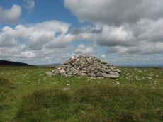
King's Oven (Water Hill) Cairn
OS Map: SX 67158 81299
HER: MDV6674
Megalithic Portal: 34690
PMD: Water Hill Possible Chambered Cairn
Alternate name: Water Hill 1 Cairn
ShortName: CN WaterHill 1
Butler map: 26.5.1
Butler Vol 5: p.156 & Fig.95
Grinsell: CHA 6
Notes: Situated at SX 67158129 on the rounded summit of Water Hill is the remains of a substantial round cairn 18.0 metres in diameter and up to 1.4 metres high in the east and 0.9 metres in the west. The whole of the central area of the cairn has been robbed to construct a superimposed modern boundary cairn 4.0 metres in diam and 2.1 metres high. This has given a 'dished' appearance to the cairn proper. Several large slabs averging 0.8 metres by 0.7 metres scattered around the base of the boundary cairn may be the remains of a destroyed cist.
The southern flat topped cairn measures 18 metres in diameter and 1.5 metres in height and is surmounted by a modern stone pile. A large slab situated to the south of this pile may have been part of a cist.
Nearby sites: SX 67158 81299
Distance: 1.90km
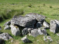
Roundy Park, Postbridge Cist
OS Map: SX 63920 79669
HER: MDV5935
Megalithic Portal: 26041
PMD: Roundy Park
Alternate name: Roundy Park Cist
ShortName: CT Roundy Pk 1
Butler map: 27.4
Butler Vol 5: p.22 & Fig.3
DPD page: 113
Grinsell: LYD 40
Barrow Report: 21
Notes: One of the largest cists on Dartmoor. Discovered in August 1893 by Robert Burnard, who was responsible for the restoration of the grave. Lethbrdige diagram p.112, photo p.113. Butler Vol. 2. Map 27.4 (diagram of location p.41, diagram of site Vol. 5 p.22). Breton p.37
Nearby sites: SX 63920 79669
Distance: 1.74km
Stannon Little Newtake Ring Setting Cairn and Cist
OS Map: SX 65464 81068
HER: MDV6616
Megalithic Portal: 37598
PMD: Stannon Newtake
Alternate name: Stannon Newtake E. Ring Setting Cairn and Cist
ShortName: CT Stannon 1
Butler map: 35.21.1
DPD page: 124
Grinsell: LYD 29
Turner: D16
Barrow Report: 57
Notes: "Cairn survives as a 4.5 metre diameter mound up to 0.5 metres high. The western edge is denoted by a kerb of edge set slabs up to 1.15 metres high. The eastern edge is beneath a later boundary bank. A cist in the centre is a rectangular pit 1.2 metres by 0.5 metres denoted by edge set slabs". Butler Stannon Newtake E. - Vol. 2. Map 35.21 (diagram p.168). Visited again by the author 18/07/2025 and quite overgrown - the outer kerb can be seen but the cist is covered by vegetation. Breton p.45.
Nearby sites: SX 65464 81068
Distance: 0.47km

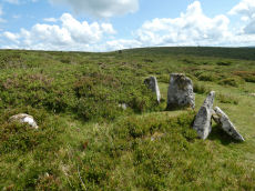
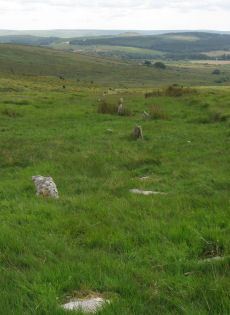
Stannon Newtake Stone Row
OS Map: SX 65348 81091
HER: MDV54555
Megalithic Portal: 2144
The Stone Rows of GB: Stannon Newtake
PMD: Stannon Newtake Stone Row
ShortName: SR Stannon New
Butler map: 35.21
Notes: HER: A group of four edge set stones standing up to 1 metre high, situated to the southeast of the cairn, represent the remains of a stone alignment.
Possible extension of the White Ridge Stone Row. "Standing stones, possibly a stone row. Forty-six feet S. of the cairn (SX 68 SE 23) are two standing stones, two and a half feet high, their broad planes facing the monument. These, and two others in line, suggest the remains of a stone row, destroyed for materials for an ancient hedge. If a row, it does not point to the centre of the cairn."
Gerrard: Following vegetation clearance by the Dartmoor Preservation Association it was found that this line of stones forms part of the White Ridge stone row and is not a row in its own right.
Radcliffe: In their Fifth Report, the Dartmoor Exploration Committee considered there to be a row to the SSW of a ruined cairn. In 1983. this was found, by TAPG and Rosemary Robinson (pers comm, see Fleming 1983) to be an extension of White ridge stone row.
See also: White Ridge Stone Row Cairn
Nearby sites: SX 65348 81091
Distance: 0.49km
White Ridge Stone Row
OS Map: SX 65420 81661
HER: MDV6642
Megalithic Portal: 4145
The Stone Rows of GB: White Ridge
PMD: White Ridge Stone Row
ShortName: SR White Ridge
Butler map: 35.20
DPD page: 125
Notes: "A double stone row, 620 ft in length from the centre of a cairn at the north end, running nearly due south and slightly downhill. Well preserved at the north end for a short distance but becoming more dilapidated as it approaches the newtake wall at the south end". Lethbridge diagram p.124 and photo top p.125. Breton p.45 sadly robbed to build the wall, but the upper part is still a good specimen of the double avenue. It is 260 yds. long; there are three stones on the S. side of the wall.
It is now thought this row continues the other side of the newtake wall and possibly leads to the Stannon Newtake row which is the terminal end. Remains beyond the wall are sparse but possibly exposed following vegetation clearance by the Dartmoor Preservation Association.
The author re-visited this site on 18/07/2025. The summer of 2025 at a similar time of year to 2014. The row seems to be far more overgrown by purple moor grass. Few of the 2014 stones can be seen today.
See also: Stannon Newtake Stone Row
Nearby sites: SX 65420 81661
Distance: 1.06km