
Guide to the Monuments on White Hill
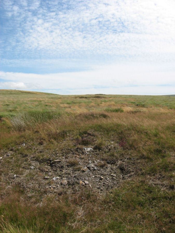
Table of Ritual and Burial Monuments on White Hill
The following table lists the records currently in this Guide Map. For an explantion of the Guide Maps and a table of all 62 Guide Maps, follow this link: Guide List Table. Introductory text will be added to each guide list in 2025. Notes on duplication and omissions will appear below the table once checks have been finalised.
Notes on possible duplications and omissions
White Hill cairn cemetries There are four of these SW, W, NE and SE. The numerous entries for all of them are a bit difficult to match up so this is a best fit. It is likely that there many more cairns than listed on here or the HER.PS. These notes are to assist untangling complicated records and are neither permanent nor a criticism of the HER who do a fantastic job! The author finds it easier to systematically work through these records (2000+ of them) and add these notes, which are then to be communicated with the HER, if appropriate, it is a pragmatic way of dealing with lots of data without continually stopping and starting.
White Hill Guide Map
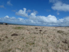
Guidance for walkers: The monuments featured in this database are archaeological treasures and need to be protected and preserved - please do not disturb any sites. Please check access and firing times before visiting sites, not all sites listed are on open access land. Firing ranges and boundaries of open access areas are marked on the OL28 OS Dartmoor Explorer map. Please stick to the country code and consider giving support to the numerous agencies that help to keep Dartmoor a fabulous natural and historic environment!
List of Ritual and Burial Monuments on White Hill
White Hill S.W. (c.9) Cairnfield Master
OS Map: SX 52600 83800
HER record: MDV50152
ShortName: CN:WhiteHilWM1
Barrow Report: 10
Notes: HER: Cairn cemetery on the south-west side of Whit Hill. A group of nine damaged cairns located on the west-facing slope of White Hill.
Nearby sites: SX52608380

White Hill S.W. Cairn Alignment
OS Map: SX 52941 83690
HER record: MDV50152
Megalithic Portal: 45821
ShortName: CR WhiteHiSW
Notes: A linear arrangement of 6 large cairns. Another two result in an L-shape. Butler: The cairn cemetery to the south-west of White Hill includes eight cairns laid out in an L-shape. Three were excavated by Baring-Gould in around 1888. Despite their comparatively large size he only found a shallow pit dug into the subsoil at the centre of each containing charcoal and ashes.
Nearby sites: SX52948369
White Hill S.W.1 Stone Ring Cairn Circle
OS Map: SX 52941 83690
HER record: MDV21078
Megalithic Portal: 45821
ShortName: RC WhiteHiSW 1
Butler map: 32.22.1
Grinsell: PET 1
Turner: A8
Notes: HER: Cairn of 15 metres diameter with a bank 3.5 metres wide by 0.5 metres high within cairn cemetery to the south-west of White Tor. Central hollow 6 metres long by 1.7 metres wide by 0.3 metres deep and The earthwork appears as a raised internal platform measuring 15m in diameter surrounded by a circular bank 3.5m wide and 0.5m high. A shallow hollow in the centre of the internal area suggests robbing or partial early excavation.
Nearby sites: SX52948369

White Hill S.W.2 Cairn
OS Map: SX 53000 83671
HER record: MDV21079
ShortName: CN:WhiteHiSW 2
Butler map: 32.22.2
Grinsell: PET 2
Barrow Report: 10 13
Notes: HER quoting Gerrrard: Flat topped round cairn. Diameter 13m, height 0.8m. Trench, 0.8m wide, 0.15m deep extends SW-NE through centre of mound. Probably result of partial excavation by Baring Gould in 1888 which produced a pan or basin containing ashes and charcoal. The N side of the mound has seen limited damage. Part of a cairn alignment.
Nearby sites: SX53008367
White Hill S.W.3 Cairn
OS Map: SX 53018 83670
HER record: MDV21083
PMD: White Hill W.
ShortName: CN:WhiteHiSW 3
Butler map: 32.22.3
Grinsell: PET 3
Barrow Report: 10
Notes: Radcliffe suggests this could be the cairn excavaed by Baring-Gould in 1888 to reveal a "A sort of rude domed kist". Part of the linear arrangement of cairns. Author visited on 18/04/2026 and missed this cairn as it is very close to S.W.2 and not obvious to make out as a distinct feature.
Nearby sites: SX53028367

White Hill S.W.4 Cairn
OS Map: SX 53048 83661
HER record: MDV21080
ShortName: CN:WhiteHiSW 4
Butler map: 32.22.4
Grinsell: PET 4
Barrow Report: 10 13
Notes: HER: Round cairn of 10 metres diameter by 0.9 metres high within cairn cemetery on the south-west side of White Hill. A central hollow of 4 metres diameter by 0.6 metres deep is probably the result of the 1888 excavation
Nearby sites: SX53058366

White Hill S.W.5 Cairn
OS Map: SX 53095 83650
HER record: MDV21081
ShortName: CN:WhiteHiSW 5
Butler map: 32.22.5
Grinsell: PET 5
Barrow Report: 10 13
Notes: HER: Cairn of 13 metres diameter by 0.5 metres high within cairn cemetery on the south-west side of White Hill. A central hollow 3 metres long by 1 metre wide by 0.1 metres deep is probably the result of the 1888 excavation, which revealed a pan or basin containing ashes and charcoal. The ditch has been infilled over the years, but survives as 2.5 metres ring of enhanced grass growth.
Nearby sites: SX53108365

White Hill S.W.6 Cairn
OS Map: SX 53137 83644
HER record: MDV21082
ShortName: CN:WhiteHiSW 6
Butler map: 32.22.6
Grinsell: PET 5a
Notes: HER: Cairn of 10 metres diameter by 0.4 metres high within cairn cemetery on the south-west side of White Hill. A central hollow 3 metres long by 2.5 metres wide by 0.3 metres deep is probably the result of the 1888 excavation which revealed a pan or basin containing ashes and charcoal
Nearby sites: SX53148364
White Hill S.W.7 Cairn
OS Map: SX 53183 83685
HER record: MDV57359
ShortName: CN:WhiteHiSW 7
Butler map: 32.22.7
Grinsell: PET 5b
Notes: HER: Cairn of 5.5 metres diameter by 0.1 metres high within cairn cemetery south-west of White Hill with a central hollow
Nearby sites: SX53188369
White Hill S.W.8 Cairn
OS Map: SX 53210 83708
HER record: MDV3210
ShortName: CN:WhiteHiSW 8
Butler map: 32.22.8
Grinsell: PET 6
Barrow Report: 10
Notes: HER: The cairn mound measures 16m in diameter and stands up to 0.4m high. This cairn has been partly damaged but archaeological levels will survive.
Nearby sites: SX53218371
White Hill S.W.9 Cairn
OS Map: SX 53006 83658
HER record: MDV17699
ShortName: CN:WhiteHiSW 9
Notes: The southern of three closely spaced round cairns, circa 4.5 metres diameter, 0.3 metres high. Grid refrence SX 53006 83658 is from Google Earth comparing with the other two cairns, it can't be seen so it is an estimate. The HER grid reference is a 14m to the south.
Nearby sites: SX53018366
White Hill S.W.10 Cairn
OS Map: SX 53088 83804
HER record: MDV103628
ShortName: CN:WhiteHiSW10
Notes: Disturbed turf-covered cairn measuring 5.9 metres in diameter composed of sandstone and slate stones with a hollow centre.
Nearby sites: SX53098380
White Hill S.W.11 Stone Ring Cairn Circle
OS Map: SX 53160 83770
HER record: MDV103627
ShortName: RC WhiteHiSW11
Notes: HER: Probable ring cairn measuring 5.7 metres in diameter by 0.3 metres high composed of sandstone and slate stones. One of a scattered group of cairns located below the summit area of White Hill at 380 metres above OD.
Nearby sites: SX53168377
White Hill S.W.12 Stone Ring Cairn Circle
OS Map: SX 52950 83860
HER record: MDV103629
ShortName: RC WhiteHiSW12
Notes: HER: Disturbed ring cairn measuring 6.0 metres in diameter by 0.3 metres high composed of sandstone and slate stones with a gap in the north-west side. One of a scattered group of cairns located below the summit area of White Hill at 380m above OD.
Nearby sites: SX52958386
White Hill S.W.13 Reported Cairn
OS Map: SX 52940 83600
HER record: MDV57360
ShortName: CN:WhiteHiSW13
Grinsell: PET 6a
Barrow Report: 10
Notes: Source is 1888 account. LVG Could not find. Could the location be wrong? Radcliffe suggests this could be PET 3.
Nearby sites: SX52948360
White Hill W. (c.24) Cairnfield Master
OS Map: SX 52600 83800
HER record: MDV3248
ShortName: CN:WhiteHilWM2
Butler map: 32.22.11
Barrow Report: 10
Notes: HER: Cairnfield on the western slope of White Hill with twenty six small stony mounds. They are likely to relate to the initial clearance phase in the construction of a field system - probably prehistoric stone clearance cairns
Nearby sites: SX52608380
White Hill W.1 Cairn
OS Map: SX 52604 83808
HER record: MDV46981
ShortName: CN:WhiteHiW 1
Notes: HER: Two cairns forming part of the cairnfield on the western slope of White Hill. Two cairns aligned east-west. The western cairn is ovoid, 4.0 metres long, 2.7 metres wide, 0.25 metres high. The eastern cairn is sub-circular, 5.0 metres in diameter, 0.55 metres high.
Nearby sites: SX52608381
White Hill W.2 Cairn
OS Map: SX 52592 83808
HER record: MDV46981
ShortName: CN:WhiteHiW 2
Notes: HER: Two cairns forming part of the cairnfield on the western slope of White Hill. Two cairns aligned east-west. The western cairn is ovoid, 4.0 metres long, 2.7 metres wide, 0.25 metres high. The eastern cairn is sub-circular, 5.0 metres in diameter, 0.55 metres high.
Nearby sites: SX52598381
White Hill W.3 Cairn
OS Map: SX 52647 83808
HER record: MDV46982
ShortName: CN:WhiteHiW 3
Nearby sites: SX52658381
White Hill W.4 Cairn
OS Map: SX 52556 83808
HER record: MDV46983
ShortName: CN:WhiteHiW 4
Nearby sites: SX52568381
White Hill W.5 Cairn
OS Map: SX 52583 83794
HER record: MDV46984
ShortName: CN:WhiteHiW 5
Nearby sites: SX52588379
White Hill W.6 Cairn
OS Map: SX 52497 83862
HER record: MDV133832
ShortName: CN:WhiteHiW 6
Nearby sites: SX52508386
White Hill W.7 Cairn
OS Map: SX 52489 83846
HER record: MDV133833
ShortName: CN:WhiteHiW 7
Nearby sites: SX52498385
White Hill W.8 Cairn
OS Map: SX 52747 83860
HER record: MDV133834
ShortName: CN:WhiteHiW 8
Nearby sites: SX52758386
White Hill W.9 Cairn
OS Map: SX 52733 83855
HER record: MDV133835
ShortName: CN:WhiteHiW 9
Nearby sites: SX52738386
White Hill W.10 Cairn
OS Map: SX 52724 83839
HER record: MDV133836
ShortName: CN:WhiteHiW10
Nearby sites: SX52728384
White Hill W.11 Cairn
OS Map: SX 52719 83834
HER record: MDV133837
ShortName: CN:WhiteHiW11
Nearby sites: SX52728383
White Hill W.12 Cairn
OS Map: SX 52693 83823
HER record: MDV133838
ShortName: CN:WhiteHiW12
Nearby sites: SX52698382
White Hill W.13 Cairn
OS Map: SX 52708 83802
HER record: MDV133839
ShortName: CN:WhiteHiW13
Nearby sites: SX52718380
White Hill W.14 Cairn
OS Map: SX 52674 83838
HER record: MDV133840
ShortName: CN:WhiteHiW14
Nearby sites: SX52678384
White Hill W.15 Cairn
OS Map: SX 52666 83874
HER record: MDV133841
ShortName: CN:WhiteHiW15
Nearby sites: SX52678387
White Hill W.16 Cairn
OS Map: SX 52672 83859
HER record: MDV133842
ShortName: CN:WhiteHiW16
Nearby sites: SX52678386
White Hill W.17 Cairn
OS Map: SX 52664 83850
HER record: MDV133843
ShortName: CN:WhiteHiW17
Nearby sites: SX52668385
White Hill W.18 Cairn
OS Map: SX 52651 83848
HER record: MDV133845
ShortName: CN:WhiteHiW18
Nearby sites: SX52658385
White Hill W.19 Cairn
OS Map: SX 52629 83833
HER record: MDV133846
ShortName: CN:WhiteHiW19
Nearby sites: SX52638383
White Hill W.20 Cairn
OS Map: SX 52602 83857
HER record: MDV133847
ShortName: CN:WhiteHiW20
Nearby sites: SX52608386
White Hill W.21 Cairn
OS Map: SX 52610 83858
HER record: MDV133847
ShortName: CN:WhiteHiW21
Nearby sites: SX52618386
White Hill W.22 Cairn
OS Map: SX 52612 83871
HER record: MDV133847
ShortName: CN:WhiteHiW22
Nearby sites: SX52618387
White Hill W.23 Cairn
OS Map: SX 52643 83856
HER: No record found
ShortName: CN:WhiteHiW23
Notes: The HER master record for the western cairn cemetery (HER=MDV3248) has a list of grid references for the cairns. Four of those don't have corresponding HER records and two of the HER records appear to be duplicates. MDV133843 is duplicated by MDV133844 and MDV133846 is duplicated by MDV133848. This record is one of the four NGRs without and HER record.
Nearby sites: SX52648386
White Hill W.24 Cairn
OS Map: SX 52659 83836
HER: No record found
ShortName: CN:WhiteHiW24
Notes: The HER master record for the western cairn cemetery (HER=MDV3248) has a list of grid references for the cairns. Four of those don't have corresponding HER records and two of the HER records appear to be duplicates. MDV133843 is duplicated by MDV133844 and MDV133846 is duplicated by MDV133848. This record is one of the four NGRs without and HER record.
Nearby sites: SX52668384
White Hill W.25 Cairn
OS Map: SX 52676 83867
HER: No record found
ShortName: CN:WhiteHiW25
Notes: The HER master record for the western cairn cemetery (HER=MDV3248) has a list of grid references for the cairns. Four of those don't have corresponding HER records and two of the HER records appear to be duplicates. MDV133843 is duplicated by MDV133844 and MDV133846 is duplicated by MDV133848. This record is one of the four NGRs without and HER record.
Nearby sites: SX52688387
White Hill W.26 Cairn
OS Map: SX 52545 83925
HER: No record found
ShortName: CN:WhiteHiW26
Notes: The HER master record for the western cairn cemetery (HER=MDV3248) has a list of grid references for the cairns. Four of those don't have corresponding HER records and two of the HER records appear to be duplicates. MDV133843 is duplicated by MDV133844 and MDV133846 is duplicated by MDV133848. This record is one of the four NGRs without and HER record.
Nearby sites: SX52558393
White Hill N.E. (c.24) Cairnfield Master
OS Map: SX 53500 84000
HER record: MDV14428
ShortName: CN:WhiteHill N
Butler map: 32.22.12
Grinsell: PET 10
Notes: Cairn field. Difficult to identify relevant HER record. The HER number (14428) linked gives a listing of the HER records of cairns in this area. The HER record 51457 gives the OS grid reference and description of 13 cairns.
Nearby sites: SX53508400

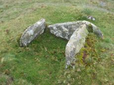
White Hill Cist
OS Map: SX 53717 84201
HER record: MDV3216
Megalithic Portal: 45783
PMD: White Hill NE.
Alternate name: White Hill N.E.1 Cist
ShortName: CT WhiteHiNE 1
Butler map: 32.22.10
Butler Vol 5: p.217 & Fig.151
DPD page: 11
Grinsell: PET 11
Notes: HER: Round cairn of 9.0 metres diameter by 0.5 metres high with a cist overlooking Walla Brook. A hollow in the centre of the mound, suggests previous robbing or partial excavation. Within the hollow, and situated on the south side, is a stone cist. The two end stones and the southern side stone are still in their original position.
Nearby sites: SX53728420
White Hill N.E.2 Cairn
OS Map: SX 53555 84004
HER record: MDV51452
ShortName: CN:WhiteHiNE 2
Nearby sites: SX53568400
White Hill N.E.3 Cairn
OS Map: SX 53571 84035
HER record: MDV51453
ShortName: CN:WhiteHiNE 3
Nearby sites: SX53578404
White Hill N.E.4 Cairn
OS Map: SX 53633 84046
HER record: MDV51454
ShortName: CN:WhiteHiNE 4
Nearby sites: SX53638405
White Hill N.E.5 Cairn
OS Map: SX 53523 84078
HER record: MDV51455
ShortName: CN:WhiteHiNE 5
Nearby sites: SX53528408
White Hill N.E.6 Cairn
OS Map: SX 53541 84080
HER record: MDV51456
ShortName: CN:WhiteHiNE 6
Nearby sites: SX53548408
White Hill N.E.7 Cairn
OS Map: SX 53440 84050
HER record: MDV51457
ShortName: CN:WhiteHiNE 7
Nearby sites: SX53448405
White Hill N.E.8 Cairn
OS Map: SX 53363 84013
HER record: MDV51458
ShortName: CN:WhiteHiNE 8
Nearby sites: SX53368401
White Hill N.E.9 Cairn
OS Map: SX 53357 84023
HER record: MDV51459
ShortName: CN:WhiteHiNE 9
Nearby sites: SX53368402
White Hill N.E.10 Cairn
OS Map: SX 53319 84004
HER record: MDV51460
ShortName: CN:WhiteHiNE10
Nearby sites: SX53328400
White Hill N.E.11 Cairn
OS Map: SX 53310 84007
HER record: MDV51461
ShortName: CN:WhiteHiNE11
Nearby sites: SX53318401
White Hill N.E.12 Cairn
OS Map: SX 53660 84050
HER record: MDV57361
ShortName: CN:WhiteHiNE12
Nearby sites: SX53668405
White Hill S.E. (c.11) Cairnfield Master
OS Map: SX 53430 83800
HER record: MDV14429
ShortName: CN:WhiteHiSE M
Notes: FIX - all inerited and wrong
Nearby sites: SX53438380
White Hill N Stone Ring Cairn Circle
OS Map: SX 53443 83898
HER record: MDV3211
Megalithic Portal: 45826
Alternate name: White Hill S.E.1 Stone Ring Cairn Circle
ShortName: RC:WhiteHiSE 1
Butler map: 32.22.9
Grinsell: PET 9
Turner: A11
Notes: NMR A - there are 2 more?! "Ring cairn 80 metres north-east of White Hill summit, forming part of the White Hill round cairn cemetery. Barrow A (diameter 15.0 metres, height 0.25 metres)."
Nearby sites: SX53448390
White Hill S.E 2 Cairn
OS Map: SX 53427 83853
HER record: MDV3212
ShortName: CN:WhiteHiSE 2
Grinsell: PET 8
Notes: NMR 440678 B. Ring cairn 50m north-east of White Hill summit forming part of the White Hill round cairn cemetery. Cairn survives as flat internal area, diameter 11 metres, surrounded by circular bank 2.3 metres wide by 0.15 metres high.
Nearby sites: SX53438385
White Hill S.E.3 Cairn
OS Map: SX 53430 83800
HER record: MDV3213
ShortName: CN:WhiteHiSE 3
Butler map: 32.22.13
Grinsell: PET 7
Notes: HER: Cairn of 9.0 metres diameter by 0.2 metres high within cairn cemetery to the south-east of White Hill. The centre is depressed to 0.3 metres deep and there is little evidence of spoil from this damaged cairn
Nearby sites: SX53438380
White Hill S.E.4 Cairn
OS Map: SX 53488 83723
HER record: MDV133816
ShortName: CN:WhiteHiSE 4
Notes: HER: Cairn of 4.0 metres diameter by 0.4 metres high within cairnfield to the south-east of White Hill
Nearby sites: SX53498372
White Hill S.E 5 Cairn
OS Map: SX 53491 83743
HER record: MDV133818
ShortName: CN:WhiteHiSE 5
Notes: HER: Cairn of 3.2 metres diameter by 0.3 metres high within cairnfield to the south-east of White Hill
Nearby sites: SX53498374
White Hill S.E 6 Cairn
OS Map: SX 53471 83776
HER record: MDV133819
ShortName: CN:WhiteHiSE 6
Notes: HER: Cairn of 4.0 metres diameter by 0.5 metres high within cairnfield to the south-east of White Hill
Nearby sites: SX53478378
White Hill S.E 7 Cairn
OS Map: SX 53399 83739
HER record: MDV133820
ShortName: CN:WhiteHiSE 7
Notes: HER: Cairn of 1.9 metres diameter by 0.3 metres high within cairnfield to the south-east of White Hill
Nearby sites: SX53408374
White Hill S.E 8 Cairn
OS Map: SX 53383 83738
HER record: MDV133821
ShortName: CN:WhiteHiSE 8
Notes: HER: Cairn of 3.25 metres diameter by 0.5 metres high within cairnfield to the south-east of White Hill
Nearby sites: SX53388374
White Hill S.E 9 Cairn
OS Map: SX 53374 83736
HER record: MDV133822
ShortName: CN:WhiteHiSE 9
Notes: HER: Cairn of 4.3 metres diameter by 0.4 metres high within cairnfield to the south-east of White Hill
Nearby sites: SX53378374
White Hill S.E 10 Cairn
OS Map: SX 53364 83727
HER record: MDV133823
ShortName: CN:WhiteHiSE10
Notes: HER: Cairn of 3.5 metres diameter by 0.2 metres high within cairnfield to the south-east of White Hill
Nearby sites: SX53368373
White Hill S.E 11 Cairn
OS Map: SX 53356 83737
HER record: MDV133824
ShortName: CN:WhiteHiSE11
Notes: HER: Cairn of 4.5 metres diameter by 0.4 metres high within cairnfield to the south-east of White Hill
Nearby sites: SX53368374
White Hill S.E 12 Cairn
OS Map: SX 53329 83758
HER record: MDV133825
ShortName: CN:WhiteHiSE12
Notes: HER: Cairn of 5.45 metres diameter by 0.7 metres high within cairnfield to the south-east of White Hill
Nearby sites: SX53338376
White Hill S.E.13 Cairn
OS Map: SX 53340 83750
HER record: MDV46586
ShortName: CN:WhiteHiSE13
Notes: This was previously listed with the NGR of SX 53460 83750 which is 120m away. That presumably came from an NMR entry that was linked to this record. This record was also linked to HER record MDV46586 and the NGR has been changed to match. i.e. it is essentially now a record based on MDV46586.
Nearby sites: SX53348375
Bearwalls Farm Cairn
OS Map: SX 53090 84060
HER record: MDV78333
ShortName: CN:Bearwalls
Notes: Indistinct cairn visible south-east of Bearwalls Farm.
Nearby sites: SX53098406
Ger Tor Platform Cairn Circle
OS Map: SX 54627 83330
HER record: MDV11809
Megalithic Portal: 45645
Alternate name: Ger Tor Summit Platform Cairn Circle
ShortName: PC:Ger Tor 1
Butler map: 32.4
Turner: E24
Notes: "Cairn on ger tor, n side. Platform circle with ring of kerb stones 4.6m internal diam, enclosing flat-topped cairn 0.2m high. Much disturbed (turner)."
UPDATE 31/12/2022. HER link changed from the now deleted MDV48908. NGRs updated accordingly to match MDV11809.
Nearby sites: SX54638333
Ger Tor 2 Reported Cairn
OS Map: SX 54570 83450
HER record: MDV132033
ShortName: CN:Ger Tor 2
Notes: "Pair of cairns identified to the north of Ger Tor." "Southern probable cairn comprising a slight ring bank some 6.5 metres in overall diameter and 0.2 metres to 0.3 metres high. Some stone is visible in the bank. Investigated as part of the Royal Commission on the Historic Monuments in England Willsworthy project."
Nearby sites: SX54578345
Ger Tor 3 Reported Cairn
OS Map: SX 54569 83474
HER record: MDV103474
ShortName: CN?Ger Tor 3
Notes: "Pair of cairns identified to the north of Ger Tor. The northernmost may prove to be of more modern origin." "Northern cairn consisting of a small irregular pile of boulders and stones up to 0.3 metres high located on a high point. It lies on a slight granite outcrop at SX54568349 and it overlooks Hamlyns Newtake. Of uncertain function it may have a relatively recent origin."
Nearby sites: SX54578347
Hamlyn Newtake Cairn
OS Map: SX 53900 83520
HER record: MDV50682
ShortName: CN:Hamylyn
Nearby sites: SX53908352
Highdown 1 Cairn
OS Map: SX 52480 84740
HER record: MDV3218
ShortName: CN?Highdown 1
Grinsell: LYD 11
Turner: A52
Nearby sites: SX52488474
Highdown 2 Clearance Cairn
OS Map: SX 52350 84680
HER record: MDV3219
ShortName: CN?Highdown 2
Grinsell: LYD 10
Notes: Post-medieval. NMR states "The mound depicted on the OS 1:10000 scale mapping (1) and described by Grinsell (2) is largely obscured by gorse. It is not of prehistoric origin as it sits upon a number of narrow cultivation ridges associated with the post medieval field system in this area. It is more likely to be a relatively recent stone clearance heap. A similar feature (440692) lies 140m to the east."
Nearby sites: SX52358468
Doe Tor Cist
OS Map: SX 54383 84846
HER record: MDV3251
Megalithic Portal: 44223
PMD: Doe Tor
Alternate name: Doe Tor E. Cist
ShortName: CT Doe Tor
Butler map: 32.21
Butler Vol 5: p.198 & Fig.141
DPD page: 10
Grinsell: LYD 12
Barrow Report: 24
Notes: Butler Doe Tor E - Vol. 2. Map 32.21 (diagram Vol. 5. p.198).
Nearby sites: SX54388485
Walla Brook Reported Cairn
OS Map: SX 54093 84344
HER record: MDV103624
ShortName: CN?Walla Brook
Nearby sites: SX54098434
Page last updated 10/12/24