
Guide to the Monuments on Belstone
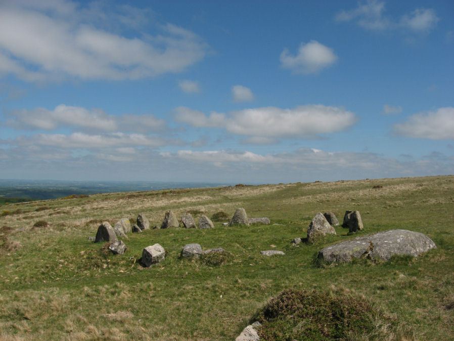
Table of Ritual and Burial Monuments on Belstone
The following table lists the records currently in this Guide Map. For an explantion of the Guide Maps and a table of all 62 Guide Maps, follow this link: Guide List Table. Introductory text will be added to each guide list in 2025. Notes on duplication and omissions will appear below the table once checks have been finalised.
Notes on possible duplications and omissions
Higher Tor S.1 (Winter Tor cist) duplicate: HER record MDV6901 is a likely duplicate of the Winter Tor cist entry MDV6881 (see Winter Tor Cist). The HER entry for this record states: Possible cist noted at Winter Tor; this could not be located during MPP field investigation.. However, there is also a reference to Barrow Report 21 which has an entry for Winter Tor cist which in turn on p.146 references Prowse's Taw marsh article of 1890. That article has a plan of the cist in Fig 2 and Fig 3 which shows the stones of MDV 6881.PS. These notes are to assist untangling complicated records and are neither permanent nor a criticism of the HER who do a fantastic job! The author finds it easier to systematically work through these records (2000+ of them) and add these notes, which are then to be communicated with the HER, if appropriate, it is a pragmatic way of dealing with lots of data without continually stopping and starting.
Belstone Guide Map
Guidance for walkers: The monuments featured in this database are archaeological treasures and need to be protected and preserved - please do not disturb any sites. Please check access and firing times before visiting sites, not all sites listed are on open access land. Firing ranges and boundaries of open access areas are marked on the OL28 OS Dartmoor Explorer map. Please stick to the country code and consider giving support to the numerous agencies that help to keep Dartmoor a fabulous natural and historic environment!
List of Ritual and Burial Monuments on Belstone
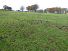
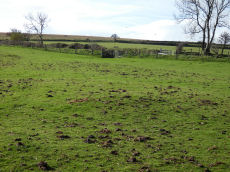
Belstone M Cairnfield Master
OS Map: SX 62600 93000
HER record: MDV64176
ShortName: CN:Belstone M
Notes: HER A cairnfield adjacent to a prehistoric settlement 780 metres south-east of Belstone parish church.
Nearby sites: SX62609300
Belstone 1 Cairn
OS Map: SX 62650 93050
HER record: MDV64173
ShortName: CN:Belstone 1
Nearby sites: SX62659305
Belstone 2 Cairn
OS Map: SX 62650 93045
HER record: MDV64174
ShortName: CN:Belstone 2
Nearby sites: SX62659305
Belstone 3 Cairn
OS Map: SX 62650 93040
HER record: MDV64175
ShortName: CN:Belstone 3
Nearby sites: SX62659304
Belstone 4 Reported Cairn
OS Map: SX 62600 93030
HER record: MDV64177
ShortName: CN:Belstone 4
Notes: HER: Three cairns and lengths of rubble walling on a north-facing slope overlooking Belstone Cleave.
Nearby sites: SX62609303
Belstone 5 Reported Cairn
OS Map: SX 62470 93150
HER record: MDV64179
ShortName: CN:Belstone 5
Notes: HER: Diameter measures 10.3m. Mound measures 3.8m diameter, 0.6m high. A complex site consisting of a 3.8m diameter central mound, with a 1m wide a 0.2m high rubble bank 0.9m from the foot of the mound on the e side. 2m beyond this is a 0.5m high scarp. On the w side of the mound and 2.5m from it is a slight bank measuring 1m wide and 0.2m high. This is probably a ring cairn with a central mound, although it might be a badly robbed stone hut circle.
Nearby sites: SX62479315
Watchet Hill Cairn
OS Map: SX 61477 93055
HER record: MDV13049
Megalithic Portal: 23222
ShortName: CN WatchetHill
Butler map: 40.12
Grinsell: BEL 3
Notes: "A Bronze Age round cairn situated on the summit of Watchet Hill. The cairn survives as a 0.8 metre high oval mound measuring 16.6 metres long north to south by 13.8 metres wide east to west. A T-shaped trench, the consequence of a partial early excavation, cuts through the central part of the mound. Adjacent to the south eastern side of the mound there is a 2.3 metre wide and 0.2 metre deep ditch. This represents the remains of the quarry ditch from which material was derived during the construction of the cairn. The ditch would have originally surrounded the mound but now survives largely as a buried feature."
Nearby sites: SX61489306
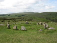
Nine Stones, Belstone Cairn Circle
OS Map: SX 61232 92849
HER record: MDV6865
Megalithic Portal: 535
PMD: The Nine Stones
Alternate name: Nine Stones Cairn Circle
ShortName: CC Nine Stones
Butler map: 40.13
DPD page: 156
Grinsell: BEL 1
Turner: G23
Barrow Report: 21 42
Notes: The "Nine Stones" cairn circle "survives as a ring of at least 16 upright stones, standing up to 0.7 metres high, surrounding a slightly raised 7 metre diameter internal area". "A loose granite boulder in the centre of the circle may cover a cist; and there are vestiges of a mound around it. Well preserved."
Nearby sites: SX61239285
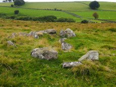
Cullever Steps Ring Setting Cairn and Cist
OS Map: SX 60787 91954
HER record: MDV6867
Megalithic Portal: 17956
PMD: Cullever Steps
ShortName: CT Cullever
Butler map: 40.14
Butler Vol 5: p.181 & Fig.123
Grinsell: BEL 2
Turner: D11
Notes: "A Bronze Age ring cairn situated below Belstone Tor within the valley of the East Okement River. The cairn survives as a 0.5 metre high bank surrounding a 4.1 metre diameter internal area. The bank around the southern and eastern side of the cairn is faced on both sides with edge set stones. A large flat stone lying on the south western part of the ring bank may represent a displaced cist coverstone. The overall dimensions of the cairn are 9.5 metres east to west by 8.5 metres north to south." Butler Vol. 2. Map 40.14 (diagram Vol. 5. p.181).
Nearby sites: SX60799195
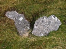
Winter Tor Cist
OS Map: SX 61112 91352
HER record: MDV6881
Megalithic Portal: 45779
PMD: Winter Tor
Alternate name: Higher Tor S.1 Cist
ShortName: CT HigherTor 1
Butler map: 40.15
Butler Vol 5: p.169 & Fig.108
Grinsell: LYD 1
Notes: [Formerly listed as Higher Tor (S), renamed after PMD] Butler Higher Tor (S) Vol. 2. Map 40.15. (diagram Vol. 5. p.169). Ths cist was excavated by Prowse as described in his article of 1890. About 300 yards south-south-east of Winter Tor is a tumulus diameter 9 yards and height 3 feet, the top of which has been hollowed out. Within the hollow was a granite slab 4 feet 6 inches by 2 feet 9 inches, covering the remains of a cist, and another slab approximately 4 feet 9 inches by 3 feet 3 inches, either a second capstone or possibly part of the first cist. The cist contained nothing of interest except a few small porous and very brittle fragments of what is apparently bony tissue. After examination the capstone was replaced and covered with soil and stones.
Nearby sites: SX61119135
Higher Tor S.1 (duplicate) Reported Cist
OS Map: SX 60900 91500
HER record: MDV6901
ShortName: CT:HigherTrDup
Notes: This is a likely duplicate of the Winter Tor cist entry HER MDV 6881. The HER entry for this record states: Possible cist noted at Winter Tor; this could not be located during MPP field investigation.. However, there s also a reference to barrow Report 21 which has an entry for winter Tor cists which in turn on p.146 references Prowse's Taw marsh article of 1890. That article has a plan of the cist in Fig 2 and Fig 3 which shows the stones of MDV 6881.
Nearby sites: SX60909150
Higher Tor S.2 Cairn
OS Map: SX 61200 91500
HER record: MDV17241
ShortName: CN:HigherTor 2
Notes: "On the south side of higher tor, belstone common, are the apparent remains of a small 'tor cairn' built around an outcrop which, although substantial, is not shown on os 6" 1965. Cairn material mainly on the northern side of the tor. Approximately 15-20m in diameter."
Nearby sites: SX61209150
Higher Tor S.3 Reported Cairn
OS Map: SX 60800 91900
HER record: MDV6902
ShortName: CN?HigherTor 3
Notes: HER: Prowse (1890) recorded a possible circle or setting here but this is thought to be a nature stone grouping [...] There is no reason to suspect that the feature described is anything other than natural and no evidence of a stone circle is visible.
Nearby sites: SX60809190
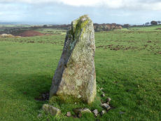
Halstock Standing Stone
OS Map: SX 60461 93334
HER record: MDV13056
ShortName: SS Halstock
Notes: HER: Small standing stone north of East Bowden, near three prehistoric cairns. Gerrard p.63: There are possible standing stones at Halstock and Butterdon Down. Two of the cairns (East Bowden 2 and 3) align on the stone.
Nearby sites: SX60469333
East Bowden 1 Reported Cairn
OS Map: SX 60480 93317
HER record: MDV13057
ShortName: CN EBowden 1
Notes: HER: Prehistoric cairn north-east of East Bowden, near to two other cairns and a small standing stone. The main photo shows a bank running behind the cairn, the second photo shows the proximity of the possible standing stone.
Nearby sites: SX60489332
East Bowden 2 Reported Cairn
OS Map: SX 60421 93274
HER record: MDV13055
ShortName: CN EBowden 2
Notes: HER: Two contiguous prehistoric cairns to the north of East Bowden. These two cairns (East Bowden 2 and 3) align on a possible standing stone (SiteID=36).
Nearby sites: SX60429327
East Bowden 3 Reported Cairn
OS Map: SX 60396 93231
HER record: MDV13055
ShortName: CN EBowden 3
Notes: HER: Two contiguous prehistoric cairns to the north of East Bowden. These two cairns (East Bowden 2 and 3) align on a possible standing stone (SiteID=36).
Nearby sites: SX60409323
Blackaven Brook Cairn
OS Map: SX 60117 91909
HER record: MDV59588
Alternate name: Harter Hill Cairn
ShortName: CN:Blackaven
Butler map: 42.4
Nearby sites: SX60129191

East Hill Fort
OS Map: SX 60397 94162
HER record: MDV6880
Megalithic Portal: 47073
ShortName: FT East Hill
Notes: "A promontory fort of likely Iron Age date containing a further, probably earlier, enclosure. It occupies an elevated position at the tip of the spur between the East Okement River and the Moor Brook. The southern and eastern sides of the site are formed by precipitous slopes that fall into wooded gorges while the west and northwest are delimited by a well-defined rampart and ditch pierced by a single entrance. The highest point within the fort, the SE quadrant, is occupied by the earlier enclosure which does not possess an entrance. Traces of ridge and furrow are visible in the southern part of the interior."
Nearby sites: SX60409416
A30 Embankment 2 Reported Cairn
OS Map: SX 60200 94600
HER record: MDV63885
ShortName: CNxA30Embank 2
Notes: HER: Circular mound 6m diameter x 0.3m high cut by the field boundary to the east + the railway embankment to the west. Interpreted as a cairn.
Nearby sites: SX60209460
Page last updated 10/12/24