
Guide to the Monuments on Yar Tor and corndon Down
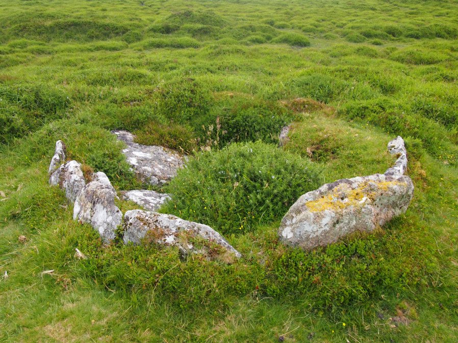
Table of Ritual and Burial Monuments on Yar Tor and corndon Down
The following table lists the records currently in this Guide Map. For an explantion of the Guide Maps and a table of all 62 Guide Maps, follow this link: Guide List Table. Introductory text will be added to each guide list in 2025. Notes on duplication and omissions will appear below the table once checks have been finalised.
Notes on possible duplications and omissions
Sherwell Reported Cairn and Corndon Tor S. Butler cairns 15.1 and 15.4.3 not listed on HER. One or both of these may not be worth listing. The 15.4.3 cairn relates to an account by Crossing and the feature is untraceable.PS. These notes are to assist untangling complicated records and are neither permanent nor a criticism of the HER who do a fantastic job! The author finds it easier to systematically work through these records (2000+ of them) and add these notes, which are then to be communicated with the HER, if appropriate, it is a pragmatic way of dealing with lots of data without continually stopping and starting.
Yar Tor and corndon Down Guide Map
Guidance for walkers: The monuments featured in this database are archaeological treasures and need to be protected and preserved - please do not disturb any sites. Please check access and firing times before visiting sites, not all sites listed are on open access land. Firing ranges and boundaries of open access areas are marked on the OL28 OS Dartmoor Explorer map. Please stick to the country code and consider giving support to the numerous agencies that help to keep Dartmoor a fabulous natural and historic environment!
List of Ritual and Burial Monuments on Yar Tor and corndon Down

Yar Tor Summit Cairn
OS Map: SX 67865 73943
HER record: MDV6434
Megalithic Portal: 11065
Alternate name: Yar Tor summit Cairn
ShortName: CN Yar Tor Sum
Butler map: 14.8
Grinsell: WID 20
Barrow Report: 56
Notes: "Large cairn (approximately 18.0 metres) built on the summit of Yar Tor; the stones have been rearranged to form a shelter. This cairn is aligned with a reave; part of the Dartmeet parallel reave system."
Nearby sites: SX67877394
Yar Tor Summit (duplicate) Cairn
OS Map: SX 67868 73945
HER record: MDV6434
ShortName: CN:Yar Tor Dup
Grinsell: WID 20a
Barrow Report: 56
Notes: Grinsell refers to a mention by RHW of a summit cairn built around natural rocks on Yar Tor. See: Barrow Report 56 p.81. This is clearly a duplicate of WID 20 (Yar Tor Summit Cairn). NB. This record is being retained for the sake of completeness in terms of the Grinsell listings.
Nearby sites: SX67877395
Yar Tor Tor Enclosure
OS Map: SX 67849 74046
HER record: MDV128748
ShortName: EN Yar Tor
Butler map: 14.8
Notes: HER quoting Newman: A Tor enclosure of uncertain date on the northern outcrop of Yar Tor. This enclosure is situated in a natural avenue between two outcrops with vertical faces on the north and south sides which has been blocked off at the western and eastern ends by artificial stone walls.
Nearby sites: SX67857405

Yar Tor (Money Pit) Platform Cairn Circle and Cist
OS Map: SX 68181 73865
HER record: MDV6460
Megalithic Portal: 1369
PMD: Money Pit
Alternate name: Money Pit Platform Cairn Circle and Cist
ShortName: CT Money Pit
Butler map: 14.11
Butler Vol 5: p.23 & Fig.4
DPD page: 122
Grinsell: WID 21
Turner: E51
Barrow Report: 56 62
Notes: "The south cairn is a very spread and slight earthwork with a centrally placed cist. Only the north and west side slabs of the cist remain in situ though a misplaced slab lies to one side of the chamber. Eleven slabs forming a kerb of approximately 3m surrounding the cist remain in situ. Several additional stones survive, protruding just above the surface of the flattened cairn, which are likely to be evidence of an outer circle with a diameter of approximately 11m". Lethbridge diagram p.122 and photo bottom p.122. Butler Money Pit - Vol. 1. Map 14.11 (photo on p.92, diagram pp.125-6).
Nearby sites: SX68187387
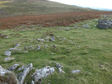
Yar Tor Stone Row
OS Map: SX 68177 73857
HER record: MDV6459
Megalithic Portal: 2199
The Stone Rows of GB: Yar Tor
PMD: Yar Tor Stone Row
ShortName: SR Yar Tor
Butler map: 14.11
DPD page: 122
Barrow Report: 56
Notes: "The remains of a probable triple stone row with a cairn and cist at its south end and a barrow at its north. The row comprises stones set 2m apart and standing to a height of 0.3m. Some are concealed beneath the turf. The cairn measures 11m in diameter and 0.3m high with a central cist surrounded by a kerb. The barrow is 6m in diameter and 1m high".
Nearby sites: SX68187386
Yar Tor N.E.1 Cairn
OS Map: SX 68014 74182
HER record: MDV14377
ShortName: CN Yar Tor N 1
Butler map: 14.11
Grinsell: WID 19
Notes: HER: Barrow north-east of Yar Tor on Corndon Down; located at the northern end of the stone row. Within area of Dartmeet parallel reave system and later prehistoric fields / enclosures. The north cairn comprises vegetation covered mound of earth, slightly ovoid in shape, 6 metres by 6.3 metres by 1 metres high.
Nearby sites: SX68017418
Yar Tor N.E.2 Reported Cairn
OS Map: SX 68170 74140
HER record: MDV6458
ShortName: CNxYar Tor N 2
Grinsell: WID 25
Notes: The remains of a despoiled hut circle on the saddle of ground between Yar Tor and Corndon Tor. Grinsell: possibly a cairn despoiled for material for the road to E; shown on 6 inch OS sheet as hut circle
Nearby sites: SX68177414
Yar Tor E.1 Clearance Cairn
OS Map: SX 68150 73840
HER record: MDV21514
ShortName: CN?Yar Tor E 1
Butler map: 14.11.1
Grinsell: WID 21a
Notes: HER 21514 includes two possibe cairs, maybe clearance cairns. WID 21a and WID 21b
Nearby sites: SX68157384
Yar Tor E.2 Clearance Cairn
OS Map: SX 68150 73830
HER record: MDV21514
ShortName: CN?Yar Tor E 2
Butler map: 14.11.2
Grinsell: WID 21b
Notes: HER 21514 includes two possibe cairs, maybe clearance cairns. WID 21a and WID 21b
Nearby sites: SX68157383
Yar Tor (SE of) Clearance Cairn
OS Map: SX 68150 73810
HER record: MDV21514
ShortName: CN?Yar Tor SE
Grinsell: WID 21c
Nearby sites: SX68157381
Yar Tor S.W. Reported Cairn
OS Map: SX 67584 73729
HER record: MDV26338
ShortName: CN?Yar Tor SW
Nearby sites: SX67587373
Yar Tor S. Reported Cairn
OS Map: SX 67950 73580
HER record: MDV16724
ShortName: CNxYar Tor S
Butler map: 14.9
Notes: Butler refers to this as a hut circle but lists as a cairn. It is clearly a hut circle. HER 16724
Nearby sites: SX67957358
Sherwell Reported Cairn
OS Map: SX 68380 74550
HER: No record found
ShortName: CN?Sherwell
Butler map: 15.1
Notes: Butler: "A small cairn lies within a neighbouring field, obviously trenched with the stones thrown downhill". Not listed on NMR or HER.
Nearby sites: SX68387455

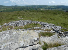
Corndon Tor 1 Cairn
OS Map: SX 68588 74227
HER record: MDV6387
Megalithic Portal: 22982
ShortName: CN CorndonTor
Butler map: 15.4.1
Barrow Report: 56 62
Notes: HER: Cairn on the summit of Corndon Tor, to the north of the main outcrop, comprising a large stony mound, constructed from moorstone with a truncated cone profile and no turf cover. Remains of a possible second cairn are located to the south on the outcrop.
Nearby sites: SX68597423
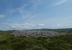
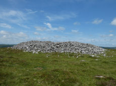
Corndon Tor 2 Cairn
OS Map: SX 68601 74158
HER record: MDV16727
ShortName: CN CorndonTor2
Butler map: 15.4.2
Grinsell: WID 18
Barrow Report: 56 62
Notes: HER: On the main outcrop of Corndon Tor is a possible tor cairn (south of MDV6387). Stones piled around the base of the outcrop may be remains of cairn which has been much disturbed and is now very spread and fragmentary The cairn overlies a reave which runs up to the tor, a shelter has been built against the tor very recently using stone from the cairn. Maximum diameter 27.2m.
The Google satellite imagery shows that this feature has the clear appearance of a tor cairn.
Nearby sites: SX68607416
Corndon Tor S. Reported Cairn
OS Map: SX 68470 73930
HER: No record found
ShortName: CN?CorndonTorS
Butler map: 15.4.3
Notes: Crossing mentions this cairn. Not traceable.
Nearby sites: SX68477393
Corndon Down 1 Cairn
OS Map: SX 68678 74766
HER record: MDV6385
ShortName: CN CorndonDn 1
Butler map: 15.5.1
Grinsell: WID 17
Barrow Report: 56 62
Notes: HER: Large stone cairn; one of a pair approximately 530m north of Corndon Tor. The eastern cairn comprises a stony mound standing to over 2m high with a flattish top surface which has been badly disturbed by recent building of shelters. One very pronounced example is in centre of the cairn and appears recent. A reave, part of the Dartmeet system, touches the cairn tangentially on the west side but is not covered by it.
Nearby sites: SX68687477
Corndon Down 2 Cairn
OS Map: SX 68579 74731
HER record: MDV6386
ShortName: CN CorndonDn 2
Butler map: 15.5.2
Grinsell: WID 16
Barrow Report: 56 62
Notes: HER: Large stone cairn; one of a pair approximately 530m north of Corndon Tor. A mound of loose stone over 2m high in places. Upper surface extensively disturbed and undulating caused by interference, including recent shelter building.
Nearby sites: SX68587473
Corndon Down 3 Cairnfield Master
OS Map: SX 68790 75210
HER record: MDV130667
ShortName: CN:CorndonDn 3
Notes: HER: Thirty-nine clearance cairns amid medieval fields on the east lower slopes of Corndon Down. The cairns comprise stony turf-covered, circular or elliptical heaps of between 2m and 5m across and up to 0.8m high. The majority of the cairns lie within a large abandoned newtake field (centred SX 6879 7521) which appears never to have been cultivated. The remainder are within smaller fields just to the east, one of which contains cultivation ridges.
Nearby sites: SX68797521
Lower Cator Clearance Cairn
OS Map: SX 68420 75800
HER record: MDV26442
ShortName: CN?Lower Cator
Butler map: 17.2
Notes: Round House reused as a clearance cairn. Butler. A cairn, with a trench across the centre, lies at the middle of a field between these huts, trimmed to a pear shape by ploughing around the edges.
HER quoting Butler: Lower Cator Prehistoric setlement includes this hut circle with a diameter of circa 6 metres with its lower half filled with clearance stones. a few slabs surround this hut. Other details: Map 17, Site 2.
Nearby sites: SX68427580
Rowden Down Reported Cairn
OS Map: SX 69930 76020
HER record: MDV12961
ShortName: CN?Rowden Dn
Grinsell: WID 23
Notes: Hut circle or ring cairn
Nearby sites: SX69937602
Wind Tor Reported Cairn
OS Map: SX 70910 75780
HER record: MDV7543
ShortName: CNxWind Tor
Butler map: 19.4
Turner: A27
Notes: HER: (quoting OS division): A hut circle in poor condition was found during field investigation in an exposed situation north-east of the summit of Wind Tor. It seems to have had an internal diameter of 6.0m, surrounded by encircling stones and bank 2-3m wide and 0.4m high. The position of the entrance could not be traced. Turner lists as a ring cairn diameter 4.6 m.
Nearby sites: SX70917578
Dunstone Cup Stone
OS Map: SX 71670 75850
HER record: MDV18864
Megalithic Portal: 45855
ShortName: CS:Dunstone
Notes: HER: Cup-marked stone at SX71677585, Dunstone. Dunstone Rock is a large, weathered undressed granite boulder aligned approximately due North-South. It is 2.4m long by 1.4m wide and 1.0m high. The surface has 13 cups which fall into two groups. Although some of the cups may be natural, Dunstone manor takes its name from this stone and is recorded in Domesday as "Dunestonetuna" suggesting a long tradition of importance attached to the stone. A tradition of paying rent money by placing money in the cups is recorded until recent times.
Nearby sites: SX71677585
Page last updated 10/12/24