
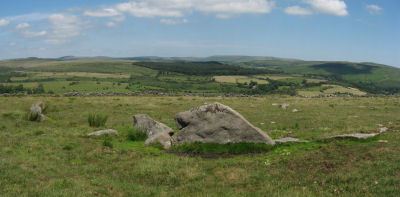
Guide to the Monuments on Holne Moor
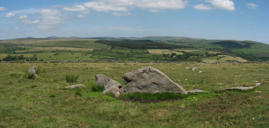
Table of Ritual and Burial Monuments on Holne Moor
The following table lists the records currently in this Guide Map. For an explantion of the Guide Maps and a table of all 62 Guide Maps, follow this link: Guide List Table. Introductory text will be added to each guide list in 2025. Notes on duplication and omissions will appear below the table once checks have been finalised.
Holne Moor Guide Map
Guidance for walkers: The monuments featured in this database are archaeological treasures and need to be protected and preserved - please do not disturb any sites. Please check access and firing times before visiting sites, not all sites listed are on open access land. Firing ranges and boundaries of open access areas are marked on the OL28 OS Dartmoor Explorer map. Please stick to the country code and consider giving support to the numerous agencies that help to keep Dartmoor a fabulous natural and historic environment!
List of Ritual and Burial Monuments on Holne Moor
Holne Lee N. Cairn
OS Map: SX 68840 70320
HER record: MDV6472
ShortName: CN:HolneLee N
Butler map: 59.1
Grinsell: HOL 7
Notes: HER: A cairn situated within the field system at SX68847032 survives as a 9.7 metre diameter flat-topped mound standing up to 0.8 metres high. A small hollow in the centre of the cairn suggests that it has been partially excavated or robbed.. Possibly visible at around 20m to the east of Butler's grid reference at SX 68864 70324 on Google satellite. This record will revert to Butler's NGR until location confirmed.
NB. record duplicated on HER as MDV129703 see SiteID=1841.
Nearby sites: SX68847032
Venford Brook W.1 Cairn
OS Map: SX 68220 71540
HER record: MDV13003
ShortName: CN:Venford W1
Butler map: 60.8.1
Notes: HER: One of four small clearance cairns within the medieval and later field system west of Venford Reservoir. The Ordnance Survey (1977) suggested these as Prehistoric cairns, but 1996 Royal Commission field survey (1996) reclassified as Medieval or later clearance mounds. It measures 4.0m in diameter and 0.4m high with a stone content, now turf and heather covered, but no particular features. It is within a reave system and 3.0m from a north to south lynchet
Nearby sites: SX68227154
Venford Brook W.2 Reported Cairn
OS Map: SX 68130 71460
HER record: MDV130254
ShortName: CNxVenford W2
Butler map: 60.8.2
Notes: HER: Four clearance cairns of medieval or later date, one previously recorded as SX 67 SE 113, lie on the crest of the ridge overlooking the W side of Venford Reservoir. All these features have diameters of around 2.5m and remain up to 0.8m high. They lie within an area of the former Dartmeet parallel reave system (SX 67 SE 95) which was heavily disturbed by agrarian activity in the historic period. There is no evidence in the form of cists or kerbs to suggest that these were once prehistoric sepulchral monuments.
Nearby sites: SX68137146
Venford Brook S.1 Reported Cairn
OS Map: SX 67630 70470
HER record: MDV128837
ShortName: CN?Venford S1
Butler map: 60.8.3
Notes: HER: Two cairns or disturbed hut circles overlain by later clearance material lie at the foot of a steep north-facing slope above the right bank of the western tributary of the Venford Brook. These features have been Scheduled as cairns. The huts are largely infilled with small boulders and rocks and measure 6.5m and 5.5m in external diameter respectively. Both possess off-centre hollows roughly 0.5m deep and neither displays evidence of a former entrance. The fact that these features appear to be terraced into the slope would preclude their interpretation as burial cairns as suggested by Butler
Nearby sites: SX67637047
Venford Brook S.2 Clearance Cairn
OS Map: SX 67640 70460
HER record: MDV128837
ShortName: CN?Venford S2
Butler map: 60.8.4
Notes: HER: Two cairns or disturbed hut circles overlain by later clearance material lie at the foot of a steep north-facing slope above the right bank of the western tributary of the Venford Brook. These features have been Scheduled as cairns. The huts are largely infilled with small boulders and rocks and measure 6.5m and 5.5m in external diameter respectively. Both possess off-centre hollows roughly 0.5m deep and neither displays evidence of a former entrance. The fact that these features appear to be terraced into the slope would preclude their interpretation as burial cairns as suggested by Butler
Nearby sites: SX67647046
Aller Brook E. (duplicate) Cist
OS Map: SX 67813 71682
HER record: MDV20166
Megalithic Portal: 45799
PMD: Aller Brook E.
ShortName: CT Aller BrkE2
Butler map: 60.11
DPD page: 90
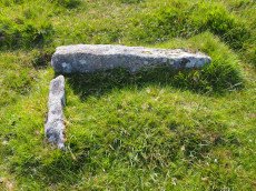
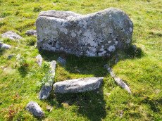
Notes: Butler Vol. 4. Map 60.11 (diagram p.181). only the four sides of the cist remain (1.0 x 0.5m), orientated WNW. Around it are two or three flat slabs of the retaining circle but the cover stone has gone as have all traces of the mound Lethbridge diagram and photo bottom left p.90
NB. The HER entry MDV126409 is duplicated with MDV20166 - see also SiteID=444
Nearby sites: SX67817168
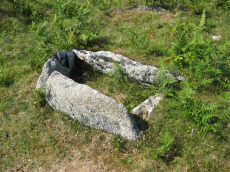
Aller Brook E Cist
OS Map: SX 67813 71682
HER record: MDV126409
Megalithic Portal: 45799
PMD: Aller Brook E.
Alternate name: Aller Brook E. Cist
ShortName: CT Aller Brk E
Butler map: 60.11
DPD page: 90
Notes: Butler Vol. 4. Map 60.11 (diagram p.181). only the four sides of the cist remain (1.0 x 0.5m), orientated WNW. Around it are two or three flat slabs of the retaining circle but the cover stone has gone as have all traces of the mound Lethbridge diagram and photo bottom left p.90.
NB. The HER entry MDV126409 is duplicated with MDV20166 - see also SiteID=1842
Nearby sites: SX67817168
Venford Reservoir S.1 Clearance Cairn
OS Map: SX 68270 70500
HER record: MDV113643
ShortName: CNxVenfordRes1
Butler map: 60.20.1
Notes: Northern cairn of pair. HER: The two features depicted as prehistoric cairns by Butler are the product of medieval or later clearance. The northern feature, at SX 68277050, measures 3.0 metres in diameter and is 0.6 metres high while the southern mound measures 1.7 metres in diameter and stands 0.5 metres high. Neither possesses traces of cist or kerb and both are undisturbed. They lie in an area which has been subject to medieval or later agrarian activity which has effaced most of the prehistoric monuments in the immediate area.
Nearby sites: SX68277050
Venford Reservoir S.2 Clearance Cairn
OS Map: SX 68260 70460
HER record: MDV113643
ShortName: CNxVenfordRes2
Butler map: 60.20.2
Notes: Southern cairn of pair. HER: The two features depicted as prehistoric cairns by Butler are the product of medieval or later clearance. The northern feature, at SX 68277050, measures 3.0 metres in diameter and is 0.6 metres high while the southern mound measures 1.7 metres in diameter and stands 0.5 metres high. Neither possesses traces of cist or kerb and both are undisturbed. They lie in an area which has been subject to medieval or later agrarian activity which has effaced most of the prehistoric monuments in the immediate area.
Nearby sites: SX68267046
Venford Reservoir S.3 Cairn
OS Map: SX 68110 70500
HER record: MDV64120
ShortName: CN:VenfordRes3
Butler map: 60.20.3
Notes: HER: Bronze Age cairn measures 6.7 metres diameter and 0.8 metres high and there is a small hollow in the centre of the mound from possible past excavation or robbing.
Nearby sites: SX68117050
Venford Reservoir Clearance Cairn
OS Map: SX 68600 70800
HER record: MDV47780
ShortName: CNxVenfordRes
Notes: HER: Several clearance cairns observed on e and w sides of venford reservoir. Max height 0.5m, but most are less than 0.3m.(greeves)
Nearby sites: SX68607080
Venford Reported Cist
OS Map: SX 68432 70973
HER record: MDV47779
PMD: Venford
ShortName: CT?Venford 1
Notes: Radcliffe: "TAPG report while reservoir low. Walls, clearance cairn and cairn, with flint flakes. Cairn 4m dia with possible cist slab 1m by 0.5m by 0.2m. Probably at 6843 7097, found 29/9/03."
Nearby sites: SX68437097
Venford 2 Clearance Cairn
OS Map: SX 67940 71000
HER record: MDV12987
ShortName: CN:Venford 2
Notes: HER: Several small clearance cairns lie on the moderate SE facing slope W of Venford reservoir. There is no evidence to suggest that these features which lie in an area of intensive medieval and later cultivation are prehistoric in origin.
Nearby sites: SX67947100
Venford 3 Clearance Cairn
OS Map: SX 67970 71010
HER record: MDV12988
ShortName: CN:Venford 3
Notes: HER: Several small clearance cairns lie on the moderate SE facing slope W of Venford reservoir. There is no evidence to suggest that these features which lie in an area of intensive medieval and later cultivation are prehistoric in origin.
Nearby sites: SX67977101
Venford 4 Clearance Cairn
OS Map: SX 68200 71170
HER record: MDV13000
ShortName: CN:Venford 4
Notes: HER: One of a group of three cairns on Holne Moor. The Ordnance Survey (1977) suggested these as Prehistoric cairns, but 1996 Royal Commission field survey (1996) reclassified as Medieval or later clearance mounds. This feature is turf covered and measures 2.7m diameter and 0.3m high, and is constructed of small boulders.
Nearby sites: SX68207117
Venford 5 Clearance Cairn
OS Map: SX 68200 71160
HER record: MDV13001
ShortName: CN:Venford 5
Notes: HER: One of a group of three cairns on Holne Moor. The Ordnance Survey (1977) suggested these as Prehistoric cairns, but 1996 Royal Commission field survey (1996) reclassified as Medieval or later clearance mounds. This feature measures 2.8m diameter and 0.6m high and is linked with MDV13002 by a slight scarp.
Nearby sites: SX68207116
Venford 6 Clearance Cairn
OS Map: SX 68190 71160
HER record: MDV13002
ShortName: CN:Venford 6
Notes: HER: One of a group of three cairns on Holne Moor. The Ordnance Survey (1977) suggested these as Prehistoric cairns, but 1996 Royal Commission field survey (1996) reclassified as Medieval or later clearance mounds. This feature measures 2.4m diameter and 0.3m high and partly turf covered.
Nearby sites: SX68197116
O Brook 1 Cairn
OS Map: SX 66317 71481
HER record: MDV103600
ShortName: CN:O Brook 1
Notes: HER: Centred SX 66327148. Three small cairns lie in open moorland on the crest of the steep valley side above the left bank of the O Brook immediately south of the current limit of cultivation.
Nearby sites: SX66327148
O Brook 2 Cairn
OS Map: SX 66418 71767
HER record: MDV103602
ShortName: CN:O Brook 2
Notes: HER Ruinous cairn lies within a settlement complex containing nine hut circles and several irregular enclosures on the gentle north-east facing slope of Slade Newtake immediately south of Saddle Bridge. NB. Described as a possible bury, or pillow mound by Butler.
Nearby sites: SX66427177
O Brook 3 Cairn
OS Map: SX 66199 71321
HER record: MDV103603
ShortName: CN:O Brook 3
Notes: "A small, circular heather-covered stony mound lies on a slope above the valley of the O'Brook. The mound measures 4.4m N-S, 4,5m E-W and is approximately 0.8m high. It is probably a burial cairn, and may well be associated with the Bronze Age settlement in the immediate area"
Nearby sites: SX66207132
O Brook 4 Cairn
OS Map: SX 66530 71360
HER record: MDV12760
ShortName: CN?O Brook 4
Notes: "a cairn 2.5m diameter, 0.4m high, in moorland. About half the circumference is kerbed, and the centre incorporates a modicum of stone, now turf-covered. Either a sepulchral feature or a solitary clearance cairn."
Nearby sites: SX66537136
O Brook 5 Reported Cairn
OS Map: SX 66500 71900
HER record: MDV6410
ShortName: CN?O Brook 5
Notes: 1902 (burnard) holne moor above saddle bridge; two cairns destroyed.
Nearby sites: SX66507190
O Brook East Hut 8 Cairn
OS Map: SX 66710 71260
HER record: MDV61477
ShortName: CN:O Brook 6
Butler map: 60.22.8
Notes: "cairn partly overlying a hut circle within a partially enclosed hut settlement 430m nw of horn's cross"
Nearby sites: SX66717126
Hooten Wheals Mine Cairn
OS Map: SX 65603 71063
HER record: MDV103597
ShortName: CN:HootenWheal
Notes: " A robbed cairn 50m SW of the ruinous former Hooten Wheals Mine offices on the S flank of Down Ridge. The turf covered stony mound is circular with a diameter of 8.0m and stands 0.75m high. A square hollow 1.6m wide, probably the result of an unrecorded excavation, lies centrally in the mound with a spoil heap on its NW margin."
Nearby sites: SX65607106
Down Ridge Stone Circle
OS Map: SX 65516 72084
HER record: MDV6400
Megalithic Portal: 863
PMD: Down Ridge Stone Circle
ShortName: SC DownRidge
DPD page: 92
Turner: G9
Notes: Also known as Hexworthy Circle. "situated on a gentle north facing slope overlooking the valley of the River Dart. The stone circle measures 25 meters in diameter and is denoted by five upright granite slabs, standing up to 1.45 meters high, which are confined to its south western sector. A further six recumbent stones lie where they have fallen. The stone circle was partially excavated in 1904 by the Dartmoor Exploration Committee and their work revealed the original ground surface covered with charcoal. An associated outlying standing stone is located 85 meters south-east of the stone circle and survives as a triangular shaped block up to 0.86 meters high." [HER MDV6400]. For photos of this site, see: Megalithic Portal: Down Ridge - Stone Circle
Nearby sites: SX65527208
Down Ridge Clearance Cairn
OS Map: SX 65775 71734
HER record: MDV103601
ShortName: CN?DownRidg 2
Notes: "A low circular turf covered mound measuring 5.0 metres in diameter and standing to a maximum of 0.6 metres high. There is no evidence to suggest the presence of a kerb or cist. Its definite interpretation as a cairn is marred by some small scale tinners diggings immediately to the NW and its unusual position on the slope."
Nearby sites: SX65787173
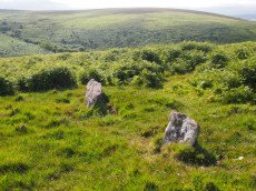
Holne Moor Stone Row
OS Map: SX 67431 71042
HER record: MDV12983
Megalithic Portal: 1981
The Stone Rows of GB: Holne Moor
PMD: Holne Moor Stone Row
ShortName: SR Holne Moor
Butler map: 60.25
DPD page: 90
Notes: "A standing stone and triple stone row lying in a secluded position, across the head of a shallow, north facing valley. It measures 147 metres long with rows on average 1.5 m apart. The stones, fifty three of which were located, have a maximum height of 0.2 m and are spaced about 1.1 m apart, each opposite the stone of the adjacent row. There is also a possible former standing stone which is now recumbent." See also MDV129985
Nearby sites: SX67437104
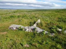
Holne Ridge N. (nr Stone Row) Reported Cist
OS Map: SX 66732 71089
HER: No record found
Megalithic Portal: 45800
ShortName: CT HolneRidgSR
DPD page: 91
Notes: Located near to cairn heading fragmentary remains of Holne Ridge stone row. Lethbridge photo top of p.90-91, diagram p.90. Not listed in the HER or by Butler. Whilst this certainly looks like a genuine cist as can be seen in the photo it is almost certainly fallen stones from the stone row that are loose on the ground and happen to be arranged to give the appearance of a cist.
Nearby sites: SX66737109
Holne Moor (N) Stone Ring Cairn Circle
OS Map: SX 68090 71620
HER record: MDV26266
Megalithic Portal: 45830
ShortName: RC:HolneMoor N
Turner: A16
Notes: "Possible cairn in corner of a field." "Stone ring 9.5m diam internally, with bank 1.2m wide and 0.4m high. Joined on w side by reave (turner)." No NMR record.
Nearby sites: SX68097162
Holne Moor Reported Cairn
OS Map: SX 67990 71450
HER record: MDV6446
ShortName: CN?Holne Moo1
Grinsell: HOL 19
Notes: Grinsell: A possible cairn with a hollow centre found at SX 6798 7140. Diameter 4.0 metres, height 0.1 metre. HER quoting OS division (1980): It is uncertain what Grinsell (1978) is referring to. At SX 6798 7140 there is an earthen ring 1.2 metres wide and 0.1 metres high, enclosing an area 2.4 metres in diameter with a military 'foxhole' trench in the northern half and traces of an infilled one on the south (See ground photograph). These occupy virtually the whole of the interior.
Nearby sites: SX67997145
Holne Ridge Stone Row
OS Map: SX 66741 71080
HER record: MDV61453
Megalithic Portal: 27341
The Stone Rows of GB: Holne Ridge
PMD: Holne Ridge Stone Row
Alternate name: Holne Ridge North Stone Row
ShortName: SR Holne Ridge
Butler map: 60.26
DPD page: 90
Notes: "One or two cairns and a short probably unfinished stone row lie in the north west facing hollow above Horse Ford on the O Brook. The cairn described by Authority 2 lies at the south end of the site with the surviving stones of the stone row to the north. As so few stones survive the exact form and extent of the rows is impossible to determine but there may have been as many as three parallel rows approximately 1.0 metre apart. Overlying or abutting the east row at SX 6672 7109 is a low turf covered mound 3.0 metes in diameter and 0.4 metres high. It is not clear whether this feature forms part of the monument or if it is associated with the shallow turf cuttings to the east."
Nearby sites: SX66747108
Holne Ridge N.1 Reported Cairn
OS Map: SX 67000 71750
HER record: MDV6445
ShortName: CN?HolneRidg 1
Butler map: 60.26.1
Grinsell: HOL 6a
Barrow Report: 24
Notes: Possibly destroyed. Butler: Holne Ridge N. '1' at SX67007175 was a fine cairn until 1878 when Crossing witnessed it 'gradually disappear under the hammer of the stone breaker'. Its remains are a disorganised rim of stone and earth which lie close to one of the parallel reaves about 25 metres from the road opposite the car park
See also SiteID=4033 which also references the Butler entry but the NGR is around 300 metres away?
Nearby sites: SX67007175
Holne Ridge N.2 stone row Cairn
OS Map: SX 66732 71089
HER record: MDV61452
ShortName: CN:HolneRidg 2
Butler map: 60.26.2
Grinsell: HOL 6b
Notes: Cairn associated with stone alignment and a second cairn to the east. This cairn stands a short distance north of the alignment and survives as a 3.8 metre diameter mound standing up to 0.4 metres high.
Nearby sites: SX66737109
Holne Ridge N. Cist
OS Map: SX 66641 71138
HER record: MDV12997
Megalithic Portal: 45800
PMD: Holne Ridge N.
Alternate name: Holne Ridge N.3 Cist
ShortName: CT HolneRidg 3
Butler map: 60.26.3
DPD page: 91
Notes: Butler Cist 3 Vol. 4. Map 60.26 (diagram p.195). "A probable but unusual cist is on steep well drained, NW facing slope. It utilizes the south east side of a massive slab, 1.6m long, 0.4m thick and 0.7m high, with smaller slabs 0.6m to 0.9m long and 0.2m thick, which barely project above ground level". NW of of Holne Ridge stone row. Lethbridge p.90-91, diagram p.90, photo bottom p.91
Nearby sites: SX66647114
Holne Ridge N.4 Cairn
OS Map: SX 66920 71190
HER record: MDV12998
ShortName: CN:HolneRidg 4
Butler map: 60.26.4
Grinsell: HOL 1
Nearby sites: SX66927119
Horns Cross N. Cairn
OS Map: SX 66941 71187
HER record: MDV26276
Megalithic Portal: 27342
Alternate name: Holne Ridge N.5 Cairn
ShortName: CN HolneRidg 5
Butler map: 60.26.5
Grinsell: HOL 2
Notes: "A turf and bracken covered Bronze Age cairn forming part of a cairn cemetery on Holne Ridge. The mound measures 14 metres by 14.4 metres in diameter and standing to a height of 1.4 metres. " Butler cairn 5 map 60.15. UPDATE 03/01/2023 This record formerly linked with MDV12975 which has been deleted.
It is unclear but this record now realte to MDV26276 which is a "tin-working spoil dump".
Nearby sites: SX66947119
Horns Cross Stone Ring Cairn Circle
OS Map: SX 66921 71125
HER record: MDV6475
Megalithic Portal: 27342
Alternate name: Holne Ridge N.6 Stone Ring Cairn Circle
ShortName: RC:HolneRidg 6
Butler map: 60.26.6
DPD page: 90
Grinsell: HOL 3
Turner: A35
Notes: "Remains of cairn; one of eight cairns forming part of a cairn cemetery on Holne Ridge. Truncated cairn, or ring cairn, gap in north-east. Diameter 14 metres, height 0.3 metres."
Nearby sites: SX66927113
Holne Ridge N.7 Cairn
OS Map: SX 66920 71040
HER record: MDV6411
ShortName: CN:HolneRidg 7
Butler map: 60.26.7
Grinsell: HOL 4
Barrow Report: 24
Notes: One of eight cairns forming part of a cairn cemetery on Holne Ridge. Cairn near horn's cross. It has been excavated; there is a trench through the centre. A hole was sunk in 'calm', and contained charcoal and bones.
Nearby sites: SX66927104
Holne Ridge N.8 Cairn
OS Map: SX 66910 70990
HER record: MDV61451
ShortName: CN:HolneRidg 8
Butler map: 60.26.8
Notes: ? NMR B
Nearby sites: SX66917099
Holne Moor Stone Ring Cairn Circle
OS Map: SX 66919 70785
HER record: MDV6474
Megalithic Portal: 27342
Alternate name: Holne Ridge N.9 Stone Ring Cairn Circle
ShortName: RC HolneRidg 9
Butler map: 60.26.9
Grinsell: HOL 5
Turner: A12
Notes: "One of four cairns 310 metres south of Horn's Cross forming part of a cairn cemetery on Holne Ridge. Ring cairn measuring 19.9 metres in diameter, height 0.9 metres. Has a 4 metre wide bank standing up to 0.9 metres high surrounding an 11.9 metre diameter internal area. A stone on the inner face of the east side of the cairn has been cut by tear and feather."
Nearby sites: SX66927079
Holne Ridge N.10 Cairn
OS Map: SX 66904 70672
HER record: MDV6473
ShortName: CN:HolneRidg10
Butler map: 60.26.10
Grinsell: HOL 6
Nearby sites: SX66907067
Holne Ridge N.11 Cairn Circle
OS Map: SX 66698 70020
HER record: MDV61447
ShortName: CN:HolneRidg11
Butler map: 60.26.11
Notes: Ring cairn
Nearby sites: SX66707002
Holne Ridge N.12 Cairn
OS Map: SX 66740 71078
HER record: MDV12981
ShortName: CN:HolneRidg12
Nearby sites: SX66747108
Holne Ridge N.13 Cairn
OS Map: SX 66990 70457
HER record: MDV61448
ShortName: CN:HolneRidg13
Notes: Cairn forms part of a cairn cemetery on Holne Ridge. Diameter 7.6 metres, height 1.0 metre. Central pit 1.1 metres wide, 0.6 metres deep. At the south-east end is a large slab which may represent a stone from a displaced cist.
Nearby sites: SX66997046
Holne Ridge N.14 Cairn
OS Map: SX 66720 70820
HER record: MDV61456
ShortName: CN:HolneRidg14
Notes: Cairn built upon an earlier stone hut circle situated within an agglomerated enclosure 330m sw of horn's cross
Nearby sites: SX66727082
Holne Ridge N.15 Cairn
OS Map: SX 66940 70130
HER record: MDV6476
ShortName: CN:HolneRidg15
Nearby sites: SX66947013
Holne Ridge N.16 Cairn
OS Map: SX 66810 71090
HER record: MDV6506
ShortName: CN:HolneRidg16
Nearby sites: SX66817109
Holne Ridge N.17 Reported Cairn
OS Map: SX 66559 70716
HER record: MDV103596
ShortName: CN?HolneRidg17
Notes: A cluster of five small cairns on the slope above the left bank of Yonder Dry Lake. With one exception the cairns are all slightly ovoid with diameters in the range 3.5 metres to 7.0 metres and stand an average of 0.7m high. The two northernmost cairns have been heavily disturbed. None of these features display evidence of cists or kerbs.
Nearby sites: SX66567072
Hexworthy (near) Reported Cist
OS Map: SX 65500 72500
HER record: MDV13004
PMD: Hexworthy
ShortName: CT?Hexworthy
Grinsell: LYD 109
Notes: Destroyed for road building, report by Burnard
Nearby sites: SX65507250
Yartor Down S.E. (site of) Reported Cist
OS Map: SX 68280 73290
HER record: MDV6422
PMD: Ollsbrim
ShortName: CT?YartorDown
Notes: A cist was alleged at this location but there is no ground evidence to substantiate this. (Worth 1948)
Nearby sites: SX68287329
Holne Lee N. (Duplicate) Cairn
OS Map: SX 68840 70320
HER record: MDV129703
ShortName: CN:HolneLeDup
Butler map: 59.1
Grinsell: HOL 7
Notes: This is record MDV129703 on the HER which is a duplicate of MDV6472 both referring to the cairn 59.1 Holne Lee N Butler grid reference SX 6884 7032. See also SiteID=1830.
Nearby sites: SX68847032
Page last updated 10/12/24