
Prehistoric sites within 5km of SX 81571 78466
Guidance for walkers: The monuments featured in this database are archaeological treasures and need to be protected and preserved - please do not disturb any sites. Please check access and firing times before visiting sites, not all sites listed are on open access land. Firing ranges and boundaries of open access areas are marked on the OL28 OS Dartmoor Explorer map. Please stick to the country code and consider giving support to the numerous agencies that help to keep Dartmoor a fabulous natural and historic environment!
About the database listings: In all listings clicking on the photo or the site name will open a page for the site with a larger photo and further details from the database. The database now has over 6680 records covering nearly all publicly listed sites on Dartmoor including around 4800 round houses. This level of detail is of interest to archaeologists but tends to swamp listings of sites more likely to be of interest for walkers. For this reason, the listings default to around 550 core sites only. These are the stone circles, stone rows and the ring cairns listed by Turner. The default search radius is 2 km. The controls below the map can be used to start a new search by entering a 6- or 8-digit reference (without the prefix "SX"). The search radius can be specified and you can add incremental Display layers of detail on top of the core sites. If using a more detailed layer you will need to decrease the search radius to avoid getting hundreds of search results.
- Core sites Default listing of core sites consisting of stone circles & rows and some of the major ring cairns.
- Plus cairns adds approx. 1000 cairns and other minor sites not included in the core listings but excluding round houses.
- Plus round houses adds approx. 4800 round houses.
- Plus non-sites adds in the records for sites that no longer exist or are not prehistoric sites.
- Plus duplicates adds records excluded as duplicates. Those maybe duplicate records in external listings (e.g. the Historic Environment Records). For example, some sites have been identified as cairns in some listings and interpreted as round houses in other listings and both records appear.
These listings have incorporated, matched up and merged all of the records from all of the major archaeological listings including: Worth, Grinsell, Turner, Butler, Bill Radcliffe, Sandy Gerrard, Megalithic Portal, the National Monument Records and the Historic Environment Records. The author would like to thank Bill, Sandy, the lovely people both at Megalithic Portal (especially Anne Tate who did an amazing job to link listings) and at ACE Archaeology for collaborative work over the years to synchronise and correct listings across the various websites which now interlink. A culmination of years of work the final merger of cairn records took 3 months of cross referencing in 2017 the result being a snapshot of the records at that time. This data has in turn been refined since by field work and research. The round house data was supplied by Sandy Gerrard. Grid references are in order of accuracy: from Google Earth satellite, if visible and found, from a Garmin GPS reading, if visited by the author and from the literature otherwise. Individual site pages will state the source of the grid reference and provide satellite imagery. If a site listing lacks a photo it has not yet been visited by the author in which case the grid reference is from the literature.
Currently the database only includes sites which can be represented by a grid reference. Reaves are not included as they require GIS shape technology which is beyond the current capability of this system. To see the sources for the records, look at the tables on the resources menu. The database listings can also be viewed on a Google map and downloaded as GPS datasets for Garmin devices.
Corrections, or any feedback or suggestions are very welcome, email: info@dartmoorwalks.org.uk.
NOTE: Clicking on the icons for each monument in the map will give the name of the site. You can zoom in and out and drag the map around.
List of sites within 5km of SX 81571 78466
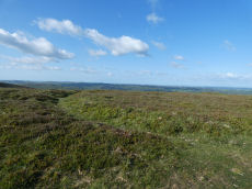
Haytor Down N.3 Reported Cairn
OS Map: SX 76599 78154
HER: MDV8105
ShortName: CN-Haytor N3
Butler map: 2.6.3
Butler Vol 5: p.191 & Fig.134
Notes: One of group of 4 cairns - see Butler for diagram in Vol 1 and 5. Maybe medieval ditch. "Sited at SX76597814 on a gently sloping northern summit of the Haytor Down spur, is a circular ditch with a level interior and slight external bank. The well-defined ditch has a V profile and a diameter of 24m. It is 1.9m wide and survives to a depth of 0.6m. The external bank, where visible is approximately 1.5m wide. The southern quadrant has been overlain by a modern footpath. The unsilted appearance of the ditch suggests this is not a prehistoric feature."
Nearby sites: SX 76599 78154
Distance: 4.98km
Hisley Wood 4 Reported Cairn
OS Map: SX 77688 80828
HER: MDV114538
ShortName: CN:HisleyWd 4
Notes: HER: Stone pile which may be the result of field clearance noted in the wood, near 1960s logging track
Nearby sites: SX 77688 80828
Distance: 4.54km
Hisley Wood 2 Reported Cairn
OS Map: SX 77391 80669
HER: MDV114528
ShortName: CN:HisleyWd 2
Notes: HER: Substantial stone mounds though to be related to field clearance noted 10 metres from a second mound in the wood.
Nearby sites: SX 77391 80669
Distance: 4.73km
Hisley Wood 1 Reported Cairn
OS Map: SX 77226 80632
HER: MDV114521
ShortName: CN:HisleyWd 1
Notes: "Stone piles or possible cairns noted in the wood. Few details given; may be related to clearance."
Nearby sites: SX 77226 80632
Distance: 4.85km
Hisley Wood 3 Reported Cairn
OS Map: SX 77384 80928
HER: MDV114526
ShortName: CN:HisleyWd 3
Notes: "Stone mound noted below path from Bovey Combe to Clam Bridge. No measurements provided. Unlikely to be related to field clearance due to steepness of slope."
Nearby sites: SX 77384 80928
Distance: 4.86km
Haytor Down N.2 Cairn
OS Map: SX 76626 78145
HER: MDV8106
ShortName: CN Haytor N2
Butler map: 2.6.2
Butler Vol 5: p.191 & Fig.133
Grinsell: ILS 6
Notes: One of group of 4 cairns - see Butler for diagram in Vol 1 and 5.
Nearby sites: SX 76626 78145
Distance: 4.96km
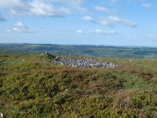
Haytor Down Stone Ring Cairn Circle
OS Map: SX 7670 7811
HER: MDV48849
Megalithic Portal: 45820
Alternate name: Haytor Down N.1 Stone Ring Cairn Circle
ShortName: RC:Haytor N1
Butler map: 2.6.1
Butler Vol 5: p.190 & Fig.132
Turner: A7
Notes: "Ring cairn on Haytor Down. Stone ring 21.0 meters internal diameter, with bank 1.5 meters wide and 0.4 meters high. Modern entrance." One of group of 4 cairns - see Butler for diagram in Vol 1 and 5.
Nearby sites: SX 7670 7811
Distance: 4.88km
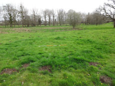
Parke 1 Reported Cairn
OS Map: SX 80945 78436
HER: MDV122315
ShortName: CN-Parke 1
Notes: "The circular ditched crop mark sits at the end of a natural grassy promontory that appears to be surrounded by two linear earthworks, giving it a view over the marshes to the north-east. The grid reference is 809784. From the measurements, it appears that it is almost a perfect circle. The ditch is unbroken."
"Measurements
North to South (From outer edges of the crop mark ring) - 7 metres 50 cm
North to South (From inner edges of the crop mark ring) - 4 metres 70 cm
East to West (From outer edges of crop mark ring) - 7 metres 80 cm
East to West (From inner edges of crop mark ring) - c.5 metres"
Photo by Jowan Albon. Reproduced with permission, copyright remains with Jowan Albon.
Nearby sites: SX 80945 78436
Distance: 0.63km
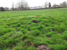
Parke 2 Reported Cairn
OS Map: SX 81007 78329
HER: MDV122310
ShortName: CN-Parke 2
Notes: "Low grassy mound, with a slight ring apparent, it is about half a meter high and sits on the edge of a slight marshy area in a field dominated by an oak tree. It sits in the field behind the Bovey Tracey Fire station, located to the right side of the main path."
"Measurements
North to South (Including ring, there appears to be a slight ring around it not apparent in photos), 5 metres 80 cm
North to South (W/o ring) - 3 metres 20cm
East to West (Including ring) 6 metres 60cm
East to West (W/o ring) 4 metres 40cm"
Photo by Jowan Albon. Reproduced with permission, copyright remains with Jowan Albon.
Nearby sites: SX 81007 78329
Distance: 0.58km
Tottiford Stone Circle
OS Map: SX 81095 83161
HER: MDV102539
Megalithic Portal: 24205
PMD: Tottiford Reservoir
ShortName: SC Tottiford
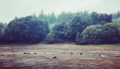
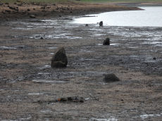
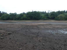
Notes: The Tottiford circle was discovered in 2009 when there was lower than usual levels of water in Tottiford reservoir; it featured as part of a Time Team dig in 2010. Normally it is submerged within the reservoir. During the drought of August 2022 the stones were exposed again for the first time for years. Photo by Zoe Lester taken on 04/09/22. Reproduced with kind permission - copyright remains with Zoe.
Nearby sites: SX 81095 83161
Distance: 4.72km
Tottiford Reservoir 1 Stone Row
OS Map: SX 81137 83093
HER: MDV102540
Megalithic Portal: 24205
The Stone Rows of GB: Tottiford Reservoir 1
PMD: Tottiford Reservoir Stone Rows
ShortName: SR Tottiford 1
Notes: "This stone row was initially noticed in late 2009, when the reservoir was only 6% full. This double stone row is aligned roughly north-west - south-east and is at least 54 meters in length. The size and form of the stones used varies considerably but the two rows are consistently 1.2 meters apart. The row leads directly to (or away from) the naturally occurring mound south-east of the stone circle." This row will be normally covered by the Tottiford Reservoir. The stones of the row were exposed for a short period following the drought of August 2022. From the northenern end the author took a photo at SX 81135 83102 (6/9/22). It was too muddy to get any closer and the grid reference of SX 81137 83093 is inferred and used for this entry. Max Piper visited the day before and got as close as SX 81129 83102 which is consistent with the inferred actual location.
Nearby sites: SX 81137 83093
Distance: 4.65km
Tottiford Reservoir 2 Stone Row
OS Map: SX 81104 83202
HER: MDV102542
The Stone Rows of GB: Tottiford Reservoir 2
PMD: Tottiford Reservoir
Alternate name: Tottiford Reservoir II Stone Row
ShortName: SR Tottiford 2
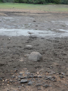
Notes: Excavated during the Time Team dig in 2011. This row will be normally covered by the Tottiford Reservoir. The stones of the row were exposed for a short period following the drought of August 2022. See Wessex Archaeology report Tottiford Reservoir: Archaeological Evaluation and Assessment of Results. See also Legendary Dartmoor - Time Team at Tottiford. The NGR used here is the eastern end from Max Piper (visit 05/09/22). Max recorded SX 81104 83202 for eastern end and SX 81077 83202 for western end. The author vistied on 06/09/22 and obtained SX 81117 83210 for the eastern end. The listing uses Max's NGR.
Nearby sites: SX 81104 83202
Distance: 4.76km
Tottiford Reservoir Mound Cairn
OS Map: SX 81121 83132
HER: MDV102544
ShortName: CN Tottiford
Notes: "A total of 156 pieces of worked flint were recovered from the excavation, with the majority of the material found consisting of debitage from flint working, most of which is small enough to qualify as chips. The small size of much of the material, the indications of blade and bladelet technology and one triangular platform rejuvenation flake, suggest a date in the (probably later) Meolithic for most of the material."
"A number of tools were recovered, including a neat end scraper of probable late Neolithic date, a notched flake of probable Meolithic date, an unstratified piercer and a crude end scraper from an unstratified location."
"The 2010 excavation of test pits on the mound confirmed the presence of worked flint and concluded the mound was a natural feature and also suggested that the presence of the flint could be the result of selective deposition by water originating upstream."
Nearby sites: SX 81121 83132
Distance: 4.69km