
Prehistoric sites within 2km of SX 62120 90480
Guidance for walkers: The monuments featured in this database are archaeological treasures and need to be protected and preserved - please do not disturb any sites. Please check access and firing times before visiting sites, not all sites listed are on open access land. Firing ranges and boundaries of open access areas are marked on the OL28 OS Dartmoor Explorer map. Please stick to the country code and consider giving support to the numerous agencies that help to keep Dartmoor a fabulous natural and historic environment!
About the database listings: In all listings clicking on the photo or the site name will open a page for the site with a larger photo and further details from the database. The database now has over 6680 records covering nearly all publicly listed sites on Dartmoor including around 4800 round houses. This level of detail is of interest to archaeologists but tends to swamp listings of sites more likely to be of interest for walkers. For this reason, the listings default to around 550 core sites only. These are the stone circles, stone rows and the ring cairns listed by Turner. The default search radius is 2 km. The controls below the map can be used to start a new search by entering a 6- or 8-digit reference (without the prefix "SX"). The search radius can be specified and you can add incremental Display layers of detail on top of the core sites. If using a more detailed layer you will need to decrease the search radius to avoid getting hundreds of search results.
- Core sites Default listing of core sites consisting of stone circles & rows and some of the major ring cairns.
- Plus cairns adds approx. 1000 cairns and other minor sites not included in the core listings but excluding round houses.
- Plus round houses adds approx. 4800 round houses.
- Plus non-sites adds in the records for sites that no longer exist or are not prehistoric sites.
- Plus duplicates adds records excluded as duplicates. Those maybe duplicate records in external listings (e.g. the Historic Environment Records). For example, some sites have been identified as cairns in some listings and interpreted as round houses in other listings and both records appear.
These listings have incorporated, matched up and merged all of the records from all of the major archaeological listings including: Worth, Grinsell, Turner, Butler, Bill Radcliffe, Sandy Gerrard, Megalithic Portal, the National Monument Records and the Historic Environment Records. The author would like to thank Bill, Sandy, the lovely people both at Megalithic Portal (especially Anne Tate who did an amazing job to link listings) and at ACE Archaeology for collaborative work over the years to synchronise and correct listings across the various websites which now interlink. A culmination of years of work the final merger of cairn records took 3 months of cross referencing in 2017 the result being a snapshot of the records at that time. This data has in turn been refined since by field work and research. The round house data was supplied by Sandy Gerrard. Grid references are in order of accuracy: from Google Earth satellite, if visible and found, from a Garmin GPS reading, if visited by the author and from the literature otherwise. Individual site pages will state the source of the grid reference and provide satellite imagery. If a site listing lacks a photo it has not yet been visited by the author in which case the grid reference is from the literature.
Currently the database only includes sites which can be represented by a grid reference. Reaves are not included as they require GIS shape technology which is beyond the current capability of this system. To see the sources for the records, look at the tables on the resources menu. The database listings can also be viewed on a Google map and downloaded as GPS datasets for Garmin devices.
Corrections, or any feedback or suggestions are very welcome, email: info@dartmoorwalks.org.uk.
NOTE: Clicking on the icons for each monument in the map will give the name of the site. You can zoom in and out and drag the map around.
List of sites within 2km of SX 62120 90480
Cosdon Beacon Cairn
Prehistoric Dartmoor Walks: Dartmoor Site: Cosdon Hill Triple Stone Row
OS Map: SX 63611 91502
HER: MDV6885
Megalithic Portal: 10325
Alternate name: Cosdon Beacon 1 Cairn
ShortName: CN Cosdon 1
Butler map: 40.7.1
DPD page: 153
Grinsell: ST 3
Notes: Cairn 27m diameter, height 1.8m, crowned by modern stone heap and OS trig pillar. Large hollows in the top, from robbing, would have protected beacon fires. Butler Cosdon Beacon 1 Vol. 2. Map 40.7.1. (diagram of Cosdon Summit cairns on p.207). See also MDV6883.
Nearby sites: SX 63611 91502
Distance: 1.81km
Cosdon Beacon Cairn Circle & Cist
Prehistoric Dartmoor Walks: Dartmoor Site: Cosdon Hill Triple Stone Row
OS Map: SX 63730 91654
HER: MDV6925
Megalithic Portal: 10325
Alternate name: Cosdon Hill 4 Cairn Circle & Cist
ShortName: CN Cosdon 4
Butler map: 40.7.4
Butler Vol 5: p.183 & Fig.125
DPD page: 153
Grinsell: ST 1b
Notes: "Cairn mound measures 7m in diam and stands up to 0.6m high. A central hollow, 2m by 1.8m by 1m deep, is faced on two sides with large slabs which may represent the cist described by falcon in 1905 as being 4ft long by 2ft wide. A ring of edge set stones around this cist is visible and may represent an internal kerb, which survives largely as a buried feature.". Lethbridge diagram p.152, photo bottom left p.153. Butler Cosdon Beacon 4 Vol. 2. Map 40.7.4 (diagram of Cosdon Summit cairns on p.207). Barrow Report 4 quotes Rowe (1872) and Rowe on this feature. See also Bate (1862) and Rowe's earlier account (1830). For Falcon's cist (1905) "Two stones set on edge on the eastern periphery of the mound may represent a second cist." see entry SiteID=463. NB. The grid reference SX 63730 91654 had been assigned by the author to this feature - possibly as read from Google or a subsequent visit. Unfortunately no explanation can be found so rolling back to previous Garmin reading taken on 12/09/21.
Nearby sites: SX 63730 91654
Distance: 1.99km
Cosdon Beacon Embanked Cairn Circle and Cist
Prehistoric Dartmoor Walks: Dartmoor Site: Cosdon Hill Triple Stone Row
OS Map: SX 63708 91593
HER: MDV6898
Megalithic Portal: 10325
PMD: Cosdon Summit S.
Alternate name: Cosdon Hill 3 Embanked Cairn Circle and Cist
ShortName: CT Cosdon 3
Butler map: 40.7.3
Butler Vol 5: p.164 & Fig.105
DPD page: 152
Grinsell: ST 2
Turner: B14
Barrow Report: 21
Notes: "Ring cairn and cist on summit ridge of Cawsand Hill. Cairn forms part of a cemetery including at least 2 round cairns, 2 ring cairns and one platform cairn. Earthwork survives as a 2m wide and 0.4m high circular rubble bank, faced with close set stones around its outer edge and surrounds an internal area measuring 18m ew by 17m ns. A mound measuring 6m in diam and 0.2m high stands in the centre of the area enclosed by the circular bank and contains a stone cist with 2 slabs surviving." Turner B14(diagram p.59). Butler Cosdon Beacon 3 Vol. 2. Map 40.7.3 (diagram Vol. 5. p.164). NMR Cairn B. Possible cist? This site is difficult to photograph, the photo shows part of one side of the ring.
Nearby sites: SX 63708 91593
Distance: 1.94km
Cosdon Beacon Reported Cairn
Prehistoric Dartmoor Walks: Dartmoor Site: Cosdon Hill Triple Stone Row
OS Map: SX 63716 91666
Alternate name: Cosdon Hill 7 Reported Cairn
ShortName: CN Cosdon 7
DPD page: 153
Notes: An arrangement a few paces north of cosdon Hill 4 and of a very similiar appearance. Might be a modern arrangement, perhaps the work of stone cutters? There is a notable cist shaped hole within this feature. Lethbridge diagram p.152, photo bottom right p.153. This feature appears not to be mentioned anywhere else.
Nearby sites: SX 63716 91666
Distance: 1.99km
Cosdon Beacon East Stone Ring Cairn Circle
Prehistoric Dartmoor Walks: Dartmoor Site: Cosdon Hill Triple Stone Row
OS Map: SX 63663 91492
HER: MDV6928
Megalithic Portal: 10325
Alternate name: Cosdon Beacon 2 Stone Ring Cairn Circle
ShortName: RC Cosdon 2
Butler map: 40.7.2
DPD page: 152
Grinsell: ST 4
Turner: A6
Notes: Located 25m to east of Cosdon Beacon. A near circular bank 1.6m wide of double slab construction and about 21m across. Turner A6 (diagram p.59). NMR Cairn A. Butler Cosdon Beacon 2 Vol. 2. Map 40.7.2. (diagram of Cosdon Summit cairns on p.207).
Nearby sites: SX 63663 91492
Distance: 1.85km
Cosdon Hill (West) Enclosed Settlement
OS Map: SX 63078 91486
HER: MDV52466
ShortName: ES:CosdonW
Notes: HER: Southern of two settlement to the south-west of Cosdon Hill of 86 metres by 56 metres with at least three enclosed areas and at least eleven hut circles. A short distance to the north is a second settlement, see MDV6920. Three or four adjoining enclosures to the south-west of Cosdon Hill with seven associated hut circles. A diagram of these enclosures can be found in Gerrard (1997), diagram 29 p.50.
Nearby sites: SX 63078 91486
Distance: 1.39km
Cullever Steps Ring Setting Cairn and Cist
OS Map: SX 60787 91954
HER: MDV6867
Megalithic Portal: 17956
PMD: Cullever Steps
ShortName: CT Cullever
Butler map: 40.14
Butler Vol 5: p.181 & Fig.123
Grinsell: BEL 2
Turner: D11
Notes: "A Bronze Age ring cairn situated below Belstone Tor within the valley of the East Okement River. The cairn survives as a 0.5 metre high bank surrounding a 4.1 metre diameter internal area. The bank around the southern and eastern side of the cairn is faced on both sides with edge set stones. A large flat stone lying on the south western part of the ring bank may represent a displaced cist coverstone. The overall dimensions of the cairn are 9.5 metres east to west by 8.5 metres north to south." Butler Vol. 2. Map 40.14 (diagram Vol. 5. p.181).
Nearby sites: SX 60787 91954
Distance: 1.99km
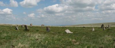
Little Hound Tor (or White Moor) Stone Circle
Prehistoric Dartmoor Walks: Dartmoor Site: Little Hound Tor Stone Circle
OS Map: SX 63285 89611
HER: MDV4374
Megalithic Portal: 528
PMD: White Moor Stone Circle
ShortName: SC White Moor
DPD page: 154
Turner: G11
Notes: The circle is in good condition today but only 13 stones remained standing when the Dartmoor Exploration Committee re-erected 5 of the stones in 1896. The site is a fairly accurate circle of circumference 20.2m. A cairn lies close to the circle, a heather covered mound about 8.5m across. The White Moor stone lies 160m to the SE of the circle and it is thought to be contemporary with the circle but probably out of position having been re-erected at some point. It is now a boundary marker. Breton p.52. See also, Legendary Dartmoor: Dartmoor's Bronze Age Landscape of Whitmoor.
Nearby sites: SX 63285 89611
Distance: 1.45km
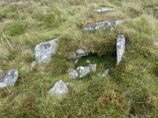
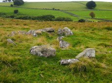
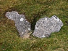
Metheral Stone Circle
OS Map: SX 62049 90436
ShortName: SC:Metheral
Nearby sites: SX 62049 90436
Distance: 0.08km
White Hill Enclosed Settlement
OS Map: SX 62656 90597
HER: MDV6887
Megalithic Portal: 36009
ShortName: ST:WhiteHill
Nearby sites: SX 62656 90597
Distance: 0.55km
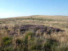
White Moor Cairn
OS Map: SX 63299 89545
HER: MDV4372
Megalithic Portal: 10327
Alternate name: White Moor Stone (NW of) Cairn
ShortName: CN White Moor
Butler map: 40.5
Grinsell: ST 7
Notes: "Cairn, nw of white moor stone … turf and heather covered, in good condition … small cairn 64m nw of whitmoor stone, … (grinsell) cairn, slightly hollowed towards centre. Diameter 7.0m, height 0.6m"
Nearby sites: SX 63299 89545
Distance: 1.50km
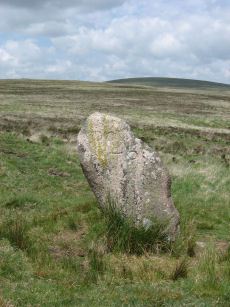
White Moor Stone Standing Stone
Prehistoric Dartmoor Walks: Dartmoor Site: Little Hound Tor Stone Circle
OS Map: SX 63359 89491
HER: MDV4391
Megalithic Portal: 10326
PMD: White Moor Stone
ShortName: SS White Moor
Butler map: 40.5
Butler Vol 5: p.53
DPD page: 154
Notes: The White Moor stone lies 160m to the SE of the Little Hound Tor stone circle and it is thought to be contemporary with the circle but probably out of position having been re-erected at some point. It is now a boundary marker.
Nearby sites: SX 63359 89491
Distance: 1.59km
Winter Tor Cist
OS Map: SX 61112 91352
HER: MDV6881
Megalithic Portal: 45779
PMD: Winter Tor
Alternate name: Higher Tor S.1 Cist
ShortName: CT HigherTor 1
Butler map: 40.15
Butler Vol 5: p.169 & Fig.108
Grinsell: LYD 1
Notes: [Formerly listed as Higher Tor (S), renamed after PMD] Butler Higher Tor (S) Vol. 2. Map 40.15. (diagram Vol. 5. p.169). Ths cist was excavated by Prowse as described in his article of 1890. About 300 yards south-south-east of Winter Tor is a tumulus diameter 9 yards and height 3 feet, the top of which has been hollowed out. Within the hollow was a granite slab 4 feet 6 inches by 2 feet 9 inches, covering the remains of a cist, and another slab approximately 4 feet 9 inches by 3 feet 3 inches, either a second capstone or possibly part of the first cist. The cist contained nothing of interest except a few small porous and very brittle fragments of what is apparently bony tissue. After examination the capstone was replaced and covered with soil and stones.
Nearby sites: SX 61112 91352
Distance: 1.33km