
Guide to the Monuments on White Ridge and Assycombe Hill

Table of Ritual and Burial Monuments on White Ridge and Assycombe Hill
The following table lists the records currently in this Guide Map. For an explantion of the Guide Maps and a table of all 62 Guide Maps, follow this link: Guide List Table. Introductory text will be added to each guide list in 2025. Notes on duplication and omissions will appear below the table once checks have been finalised.
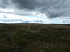
White Ridge and Assycombe Hill Guide Map
Guidance for walkers: The monuments featured in this database are archaeological treasures and need to be protected and preserved - please do not disturb any sites. Please check access and firing times before visiting sites, not all sites listed are on open access land. Firing ranges and boundaries of open access areas are marked on the OL28 OS Dartmoor Explorer map. Please stick to the country code and consider giving support to the numerous agencies that help to keep Dartmoor a fabulous natural and historic environment!
List of Ritual and Burial Monuments on White Ridge and Assycombe Hill
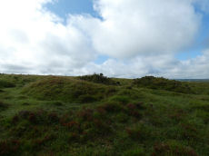
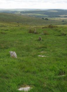
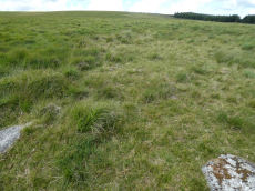
Red Barrows Cairn
OS Map: SX 67718 79650
HER record: MDV6007
Megalithic Portal: 34986
PMD: Red Barrows
Alternate name: Red Barrows 1 Cairn
ShortName: CN RedBar 1
Butler map: 24.2.1
Grinsell: MAN 5
Notes: Four Bronze Age round barrows between 10 and 20 meters in diameter and 0.5 to 2.2 meters high. One barrow was excavated in 1902, finds included pottery and flints. See also HER records, 6004, 6005, 6006, 6007.
Nearby sites: SX67727965
Red Barrows 2 Cairn
OS Map: SX 67709 79666
HER record: MDV6006
ShortName: CN RedBar 2
Butler map: 24.2.2
Grinsell: MAN 6
Barrow Report: 56
Nearby sites: SX67717967
Red Barrows 3 Cairn
OS Map: SX 67694 79690
HER record: MDV6005
ShortName: CN RedBar 3
Butler map: 24.2.3
Grinsell: MAN 7
Nearby sites: SX67697969
Red Barrows 4 Cairn
OS Map: SX 67695 79705
HER record: MDV6004
ShortName: CN RedBar 4
Butler map: 24.2.4
Grinsell: MAN 8
Nearby sites: SX67707971
Birch Tor Ancient Pool
OS Map: SX 68686 81656
HER record: MDV127183
ShortName: PO:Birch Tor
Notes: "The pool at Birch Tor measures around 15.5m. One of over 40 such 'sacred' pools identified on Dartmoor that are thought to have potentially been designed during the prehistoric period."
Nearby sites: SX68698166
Birch Tor Cairn
OS Map: SX 68686 81654
HER record: MDV6673
Megalithic Portal: 34981
Alternate name: Birch Tor Summit Cairn
ShortName: CN:Birch Tor
Butler map: 24.4
Grinsell: N.BOV 1
Barrow Report: 56
Notes: "The heavily disturbed remains of a large, flat-topped cairn lie on the ridge crest 230 metres north of Birch Tor. The centre and south margin of this feature have apparently suffered from an unrecorded excavation with spoil dumped to the south and on the east fringe of the mound. Two large upright slabs are embedded in the unexcavated interior of the cairn and may have previously been interpreted as elements of a kerb even though they lie several metres in from the actual edge of the feature. 10m to the north-west of the cairn is a warren boundary stone inscribed with the letters`WB'on its eastern side."
Nearby sites: SX68698165
Merripit Hill 1 Cairn
OS Map: SX 66359 79926
HER record: MDV103610
ShortName: CN:Merripit 1
Nearby sites: SX66367993
Merripit Hill 2 Clearance Cairn
OS Map: SX 65750 80440
HER record: MDV19555
ShortName: CN?Merripit 2
Grinsell: B:LYD 30b
Notes: On the summit of Merripit Hill is a prominent mound representing an infilled mine shaft enclosed by debris. Grinsell List B of "Doubtful and rejected sites". Entry LYDFORD 30B has the description "industrial spoil heap".
Nearby sites: SX65758044
Soussons Plantation N.1 Cairn
OS Map: SX 67673 79963
HER record: MDV6015
The Stone Rows of GB: Soussons Down
ShortName: CN:Soussons N1
Butler map: 24.2.5
Butler Vol 5: p.38 & Fig.15
Grinsell: MAN 4
Notes: Cairn at north end of the Red Barrows stone row.
Nearby sites: SX67677996
Soussons Plantation N.2 Reported Cairn
OS Map: SX 67910 79820
HER record: MDV6086
ShortName: CNxSoussons N2
Nearby sites: SX67917982
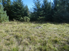
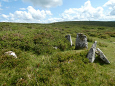
Soussons Down (Red Barrows) Stone Row
OS Map: SX 67670 79980
HER record: MDV6015
Megalithic Portal: 2136
The Stone Rows of GB: Soussons Down
PMD: Red Barrows Stone Row
Alternate name: Soussons Down Stone Row
ShortName: SR Red Barrows
Butler map: 24.2
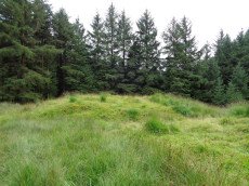
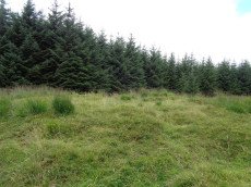
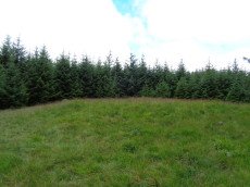
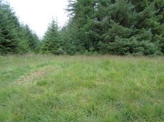
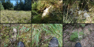
Notes: Triple row destroyed in 1946 Butler Vol. 5 p38, Vol. 2 Map 24.2 p.19. The row was associated with a cairn about 300m north of the four Red Barrow cairn group (SX 67 NE 3). Butler mentions that some of the stones of the row remained and these were observed and reported to Sandy Gerrard by Chris Jenkins. They surveyed the site in August 2020 and they found 8 of the stones remaining. The author visited the site on 24/09/2025 with Steve Szypko. It is remarkable that anything remains as the location is so disturbed and damaged by the afforestation. We searched the area and found most of the stones reported by Gerrard and Jenkins. The montage photo is of the cairn and 5 of the stones - my right foot appears in some of the photos as a way to give scale. The author thanks Steve Szypko for assistance on this task – I would not have done it alone as the terrain is dreadful. The survey by Gerrard can be found on the linked coverage on The Stone Rows of GB website.
Not all of the damage was done in 1946. The account from the 5th DEC Report in 1898 states: Due north on the ridge near Golden Dagger is a rifled cairn 31 feet in diameter, and starting from this is a very ruined and pillaged stone row, which seems when perfect to have been composed of three lines of stones. The standing examples are small, and only seven in number, but numerous fallen and buried stones can be traced. This row has been very recently destroyed, probably within the last twelve months, for the pits from which the stones contributing to the row were taken are freshly dug and very apparent. The surface of the moor for a considerable distance around the row has been carefully picked over and almost every stone removed. A newly - built wall in the near neighbourhood is the evident reason for this destruction and collection. The former was probably done in pure ignorance, for the stones were evidently mostly fallen and small, and with the surrounding surface stones not easily recognized as the work of man. Had the Committee known of this row earlier, and set up the fallen stones, the nature of the remains would have been recognized and respected. The row runs from north to south, the ruined cairn being north, and it can be traced for 202 feet.
Nearby sites: SX67677998
Kings Oven Reported Cist
OS Map: SX 67477 81336
HER record: MDV121913
PMD: King's Oven
ShortName: CT?KingsOven 1
Butler map: 26.1.2
Notes: In the wall of King's Oven enclosure. Butler gives NGR for CHA 6a by mistake.
Nearby sites: SX67488134
Kings Oven (Near) Reported Cist
OS Map: SX 67470 81290
HER record: MDV6620
ShortName: CT?KingsOven 2
Butler map: 26.5
Grinsell: CHA 6a
Notes: Destroyed? Fragmenary remains of cairn and cist reported by Speence Bate in 1871
Nearby sites: SX67478129
King's Oven (Water Hill) Cairn
OS Map: SX 67158 81299
HER record: MDV6674
Megalithic Portal: 34690
PMD: Water Hill Possible Chambered Cairn
Alternate name: Water Hill 1 Cairn
ShortName: CN WaterHill 1
Butler map: 26.5.1
Butler Vol 5: p.156 & Fig.95
Grinsell: CHA 6
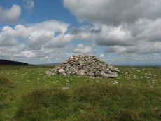
Notes: Situated at SX 67158129 on the rounded summit of Water Hill is the remains of a substantial round cairn 18.0 metres in diameter and up to 1.4 metres high in the east and 0.9 metres in the west. The whole of the central area of the cairn has been robbed to construct a superimposed modern boundary cairn 4.0 metres in diam and 2.1 metres high. This has given a 'dished' appearance to the cairn proper. Several large slabs averging 0.8 metres by 0.7 metres scattered around the base of the boundary cairn may be the remains of a destroyed cist.
The southern flat topped cairn measures 18 metres in diameter and 1.5 metres in height and is surmounted by a modern stone pile. A large slab situated to the south of this pile may have been part of a cist.
Nearby sites: SX67168130
Water Hill 2 Reported Cairn
OS Map: SX 67155 81314
HER record: MDV6675
ShortName: CN?WaterHill 2
Butler map: 26.5.2
Notes: Doubtful "a heather covered mound slightly to the n of the large cairn on the summit of water hill. It measures 5.1m in diam and up to 0.6m high with one recumbent granite boulder visible on its s side. It is apparently composed of earth and stone". This record formerly linked to MDV54619 which has presumably been deleted as a duplicate.
Visited by author on a few occasions and not recorded due to doubt about identification. The raised area in the photo is the only possible candidate for Butler's satellite cairn.
Nearby sites: SX67168131

Stannon Newtake Stone Row
OS Map: SX 65348 81091
HER record: MDV54555
Megalithic Portal: 2144
The Stone Rows of GB: Stannon Newtake
PMD: Stannon Newtake Stone Row
ShortName: SR Stannon New
Butler map: 35.21
Notes: HER: A group of four edge set stones standing up to 1 metre high, situated to the southeast of the cairn, represent the remains of a stone alignment.
Possible extension of the White Ridge Stone Row. "Standing stones, possibly a stone row. Forty-six feet S. of the cairn (SX 68 SE 23) are two standing stones, two and a half feet high, their broad planes facing the monument. These, and two others in line, suggest the remains of a stone row, destroyed for materials for an ancient hedge. If a row, it does not point to the centre of the cairn."
Gerrard: Following vegetation clearance by the Dartmoor Preservation Association it was found that this line of stones forms part of the White Ridge stone row and is not a row in its own right.
Radcliffe: In their Fifth Report, the Dartmoor Exploration Committee considered there to be a row to the SSW of a ruined cairn. In 1983. this was found, by TAPG and Rosemary Robinson (pers comm, see Fleming 1983) to be an extension of White ridge stone row.
See also: White Ridge Stone Row Cairn
Nearby sites: SX65358109
Stannon Little Newtake Ring Setting Cairn and Cist
OS Map: SX 65464 81068
HER record: MDV6616
Megalithic Portal: 37598
PMD: Stannon Newtake
Alternate name: Stannon Newtake E. Ring Setting Cairn and Cist
ShortName: CT Stannon 1
Butler map: 35.21.1
DPD page: 124
Grinsell: LYD 29
Turner: D16
Barrow Report: 57
Notes: "Cairn survives as a 4.5 metre diameter mound up to 0.5 metres high. The western edge is denoted by a kerb of edge set slabs up to 1.15 metres high. The eastern edge is beneath a later boundary bank. A cist in the centre is a rectangular pit 1.2 metres by 0.5 metres denoted by edge set slabs". Butler Stannon Newtake E. - Vol. 2. Map 35.21 (diagram p.168). Visited again by the author 18/07/2025 and quite overgrown - the outer kerb can be seen but the cist is covered by vegetation. Breton p.45.
Nearby sites: SX65468107
Stannon Newtake W. Cairn
OS Map: SX 65330 81080
HER record: MDV6657
ShortName: CN Stannon 2
Butler map: 35.21.2
Grinsell: LYD 28
Barrow Report: 15
Notes: Cairn a short distance to the north of the northernmost coaxial field boundary. The cairn survives as a 6.5m diameter mound up to 0.6m high. A central hollow is the result of excavation in 1896 which revealed a pit containing charcoal, burnt bone and a flint flake. A group of four edge set stones up to 1m high to the southeast are the remains of a stone alignment.
Nearby sites: SX65338108
Stannon Newtake a Reported Cist
OS Map: SX 64920 81230
HER record: MDV19547
PMD: Stannon Newtake a
ShortName: CN:Stannon 3
Notes: Four upright slabs form a crude semi-circle on a small shelf of an otherwise steep, e-facing and clitter strewn hillside, above stannon brook. The semi-circle described by the slabs is 3m in diam with a max height of 0.7m. It does not form a recognisable archaeological feature and seems more like random assemblage of natural slabs
Nearby sites: SX64928123
Stannon Newtake b Cairn
OS Map: SX 65193 81487
HER record: MDV15378
PMD: Stannon Newtake b
ShortName: CN:Stannon 4
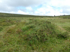
Notes: (greeves + robinson) prehistoric long cairn 16m long, 6.50m width (max), 1m high (highest at ne end). Small rectangular depression in ne end and stone slab set on edge at sw end. Composed mostly of small stone, covered with gorse and is disturbed by track at sw end. The author attempted to find this feature on 18/07/2025 and the area is covered with very dense and high gorse making it extremely difficult to access or see any potential features. Is the grid reference wrong? Looking at Lidar data the HER grid reference of SX 6518 8149 is close. It can clearly be seen on lidar at SX 65193 81487 which is 13 metres from the HER grid reference. The gird reference has been updated on this record to the Lidar feature. A screengrab of the lidar data imagery is included here with the feature highlighted.
Nearby sites: SX65198149
Stannon Bottom Cairn
OS Map: SX 65390 80600
HER record: MDV6677
ShortName: CN?Stannon 5
Grinsell: LYD 30a
Notes: Three cairns noted on the edge of a hut circle settlement on Merripit Hill. Unclear whether these are ritual or clearance cairns as they may have been hut circles that have been covered with loose stone.
Nearby sites: SX65398060
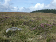
White Ridge Stone Row
OS Map: SX 65420 81661
HER record: MDV6642
Megalithic Portal: 4145
The Stone Rows of GB: White Ridge
PMD: White Ridge Stone Row
ShortName: SR White Ridge
Butler map: 35.20
DPD page: 125
Notes: "A double stone row, 620 ft in length from the centre of a cairn at the north end, running nearly due south and slightly downhill. Well preserved at the north end for a short distance but becoming more dilapidated as it approaches the newtake wall at the south end". Lethbridge diagram p.124 and photo top p.125. Breton p.45 sadly robbed to build the wall, but the upper part is still a good specimen of the double avenue. It is 260 yds. long; there are three stones on the S. side of the wall.
It is now thought this row continues the other side of the newtake wall and possibly leads to the Stannon Newtake row which is the terminal end. Remains beyond the wall are sparse but possibly exposed following vegetation clearance by the Dartmoor Preservation Association.
The author re-visited this site on 18/07/2025. The summer of 2025 at a similar time of year to 2014. The row seems to be far more overgrown by purple moor grass. Few of the 2014 stones can be seen today.
See also: Stannon Newtake Stone Row
Nearby sites: SX65428166
White Ridge Stone Row Cairn
OS Map: SX 65410 81650
HER record: MDV6639
ShortName: CN:WhiteRid 1
Butler map: 35.20
Grinsell: LYD 27
Nearby sites: SX65418165
White Ridge 2 Cairn
OS Map: SX 65027 82187
HER record: MDV20915
ShortName: CN:WhiteRid 2
Notes: HER: The monument includes a round cairn lying on the summit of White Ridge situated within Great Stannon Newtake. The cairn lies in a very prominent position and commands extensive views over much of Dartmoor. The mound measures 15.8 metres in diameter and stands up to 0.7 metres high. A number of edge set stones on the southern edge of the mound may represent a kerb, which survives elsewhere as a buried feature. Three pits in the mound suggest robbing or partial early excavation.
Nearby sites: SX65038219
Assycombe Hill S.1 Cairn
OS Map: SX 66250 81160
HER record: MDV61310
ShortName: CN:AssycombS1
Butler map: 26.4.1
Butler Vol 5: p.199
Notes: NMR 916309 clearly refers to Butler's Assycombe Hill S.1 & S.2. The entry refers to Butler's coverage Vol 2 p. 26. It is clear from Butler that the NGR is SX 662 812. This is clear both from the listingat the end of Vol2 as well as from where they are marked on Butler's Map 26. The text states "The proximity of these two cairns on te summit of the ridge 400 m to the suth-west suggests these may have been the burial mounds of the community" i.e the Assycombe Hill South settlement. However, the NGR given in the NMR is SX 662802 which is 1 km to the south! This error has resulted in duplicate entries for the HER which has this pair of cairns at both locations. HER 54601 & 54602 are duplicates (with incorrect NGRs) of 61309 & 61310.
Nearby sites: SX66258116
Assycombe Hill S.2 Cairn
OS Map: SX 66240 81180
HER record: MDV61309
ShortName: CN:AssycombS2
Butler map: 26.4.2
Butler Vol 5: p.218 & Fig.152
Notes: NMR 916309 clearly refers to Butler's Assycombe Hill S.1 & S.2. The entry refers to Butler's coverage Vol 2 p. 26. It is clear from Butler that the NGR is SX 662 812. This is clear both from the listingat the end of Vol2 as well as from where they are marked on Butler's Map 26. The text states "The proximity of these two cairns on te summit of the ridge 400 m to the suth-west suggests these may have been the burial mounds of the community" i.e the Assycombe Hill South settlement. However, the NGR given in the NMR is SX 662802 which is 1 km to the south! This error has resulted in duplicate entries for the HER which has this pair of cairns at both locations. HER 54601 & 54602 are duplicates (with incorrect NGRs) of 61309 & 61310.
Nearby sites: SX66248118
Bush Down Settlement
OS Map: SX 68490 82170
HER record: MDV6596
Megalithic Portal: 7699
ShortName: ST:BushDown
Nearby sites: SX68498217
Hurston Ridge Cairn
OS Map: SX 67003 81844
HER record: MDV6609
ShortName: CN Hurston
Butler map: 25.10
Grinsell: LYD 30
Notes: Hurston ridge; pillaged cairn (diam 8m) examined in 1900. Yielded large portion of broken urn (circumference 1.12m), resting mouth down on flat stone covering pit filled with wood charcoal. The urn was partly protected by a leaning stone kept in position by trigger stones. Highly ornamented. Dark, friable pottery containing little clay. No surrounding stone circle (worth).
See also HER record MDV6542.
Cinerary urn from Cairn at Hurston, Chagford. The urn was reconstructed in 1962 and today can be seen at the Plymouth Museum.
Butler: "Hurston Ridge Cairn at SX67008182 of circa 9.0 metres diameter by 0.2 metres high. Cairn was lost soon after it was discovered in 1900. However the cairn is still to be found on the west side of Assycombe Hill and only a triangular slab lying flat on the south-east edge of a low mound. Until 1986 another slab lay in the shallow pit at the centre which was perhaps the stone which protected the urn but this has since been taken away."
Nearby sites: SX67008184
Page last updated 10/12/24