
Prehistoric sites within 5km of SX 70501 72107
Guidance for walkers: The monuments featured in this database are archaeological treasures and need to be protected and preserved - please do not disturb any sites. Please check access and firing times before visiting sites, not all sites listed are on open access land. Firing ranges and boundaries of open access areas are marked on the OL28 OS Dartmoor Explorer map. Please stick to the country code and consider giving support to the numerous agencies that help to keep Dartmoor a fabulous natural and historic environment!
About the database listings: In all listings clicking on the photo or the site name will open a page for the site with a larger photo and further details from the database. The database now has over 6680 records covering nearly all publicly listed sites on Dartmoor including around 4800 round houses. This level of detail is of interest to archaeologists but tends to swamp listings of sites more likely to be of interest for walkers. For this reason, the listings default to around 550 core sites only. These are the stone circles, stone rows and the ring cairns listed by Turner. The default search radius is 2 km. The controls below the map can be used to start a new search by entering a 6- or 8-digit reference (without the prefix "SX"). The search radius can be specified and you can add incremental Display layers of detail on top of the core sites. If using a more detailed layer you will need to decrease the search radius to avoid getting hundreds of search results.
- Core sites Default listing of core sites consisting of stone circles & rows and some of the major ring cairns.
- Plus cairns adds approx. 1000 cairns and other minor sites not included in the core listings but excluding round houses.
- Plus round houses adds approx. 4800 round houses.
- Plus non-sites adds in the records for sites that no longer exist or are not prehistoric sites.
- Plus duplicates adds records excluded as duplicates. Those maybe duplicate records in external listings (e.g. the Historic Environment Records). For example, some sites have been identified as cairns in some listings and interpreted as round houses in other listings and both records appear.
These listings have incorporated, matched up and merged all of the records from all of the major archaeological listings including: Worth, Grinsell, Turner, Butler, Bill Radcliffe, Sandy Gerrard, Megalithic Portal, the National Monument Records and the Historic Environment Records. The author would like to thank Bill, Sandy, the lovely people both at Megalithic Portal (especially Anne Tate who did an amazing job to link listings) and at ACE Archaeology for collaborative work over the years to synchronise and correct listings across the various websites which now interlink. A culmination of years of work the final merger of cairn records took 3 months of cross referencing in 2017 the result being a snapshot of the records at that time. This data has in turn been refined since by field work and research. The round house data was supplied by Sandy Gerrard. Grid references are in order of accuracy: from Google Earth satellite, if visible and found, from a Garmin GPS reading, if visited by the author and from the literature otherwise. Individual site pages will state the source of the grid reference and provide satellite imagery. If a site listing lacks a photo it has not yet been visited by the author in which case the grid reference is from the literature.
Currently the database only includes sites which can be represented by a grid reference. Reaves are not included as they require GIS shape technology which is beyond the current capability of this system. To see the sources for the records, look at the tables on the resources menu. The database listings can also be viewed on a Google map and downloaded as GPS datasets for Garmin devices.
Corrections, or any feedback or suggestions are very welcome, email: info@dartmoorwalks.org.uk.
NOTE: Clicking on the icons for each monument in the map will give the name of the site. You can zoom in and out and drag the map around.
List of sites within 5km of SX 70501 72107
Aller Brook E. (duplicate) Cist
OS Map: SX 67813 71682
HER: MDV20166
Megalithic Portal: 45799
PMD: Aller Brook E.
ShortName: CT Aller Brk E
Butler map: 60.11
DPD page: 90
Notes: Butler Vol. 4. Map 60.11 (diagram p.181). only the four sides of the cist remain (1.0 x 0.5m), orientated WNW. Around it are two or three flat slabs of the retaining circle but the cover stone has gone as have all traces of the mound Lethbridge diagram and photo bottom left p.90
NB. The HER entry MDV126409 is duplicated with MDV20166 - see also SiteID=444
Nearby sites: SX 67813 71682
Distance: 2.72km
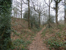
Yar Tor Tor Enclosure
OS Map: SX 67849 74046
HER: MDV128748
ShortName: EN Yar Tor
Butler map: 14.8
Notes: HER quoting Newman: A Tor enclosure of uncertain date on the northern outcrop of Yar Tor. This enclosure is situated in a natural avenue between two outcrops with vertical faces on the north and south sides which has been blocked off at the western and eastern ends by artificial stone walls. The western interior is approximately level but slopes away on the eastern side down to the wall. The north and south sides of the enclosure comprise natural linear crags of up to 2.0m high reinforced in places by large boulders. The wall at the western end is 2.1m thick and consists of a stone revetted bank with stone rubble behind surviving up to 0.8m high. The wall is slightly curved in plan. On the eastern wall there are vestiges of stone facing still in place but it is mostly collapsed and spread up to 3m wide and 0.7m high much of the wall surviving only as a disturbed stony spread. There is a possible entrance in the east wall adjacent to the northern outcrop, in the form of an opening. There are no discernable interior features.
The main photo is taken looking down from on top of one of the outcrops. Butler's possible round house can be seen within the main photo but see also a close up from ground level.
Acknowledgement: The author was unaware of this site until a walk with Steve Szypko on 25/09/2025. This record has been added as a result.
Nearby sites: SX 67849 74046
Distance: 3.29km

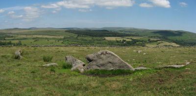
Corndon Tor 1 Cairn
OS Map: SX 68588 74227
HER: MDV6387
Megalithic Portal: 22982
ShortName: CN:CorndonTor
Butler map: 15.4.1
Barrow Report: 56 62
Notes: HER: Cairn on the summit of Corndon Tor, to the north of the main outcrop, comprising a large stony mound, constructed from moorstone with a truncated cone profile and no turf cover. Remains of a possible second cairn are located to the south on the outcrop.
Nearby sites: SX 68588 74227
Distance: 2.86km
Aller Brook E Cist
OS Map: SX 67813 71682
HER: MDV126409
Megalithic Portal: 45799
PMD: Aller Brook E.
Alternate name: Aller Brook E. Cist
ShortName: CT Aller Brk E
Butler map: 60.11
DPD page: 90
Notes: Butler Vol. 4. Map 60.11 (diagram p.181). only the four sides of the cist remain (1.0 x 0.5m), orientated WNW. Around it are two or three flat slabs of the retaining circle but the cover stone has gone as have all traces of the mound Lethbridge diagram and photo bottom left p.90.
NB. The HER entry MDV126409 is duplicated with MDV20166 - see also SiteID=1842
Nearby sites: SX 67813 71682
Distance: 2.72km
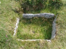
Blackslade Down Cist
OS Map: SX 73416 75519
HER: MDV7437
Megalithic Portal: 32071
PMD: Blackslade Down
ShortName: CT Blackslade
Butler map: 9.8
Butler Vol 5: p.47 & Fig.26
DPD page: 129
Grinsell: WID 14
Barrow Report: 53 56
Notes: Butler Vol. 1. Map 9.8 (photo on p.61, diagram Vol. 5. p.47). Lethbridge diagram p.129 and photo bottom p.129.
Grinsell [Folklore 1976], Widecombe cist: Opened by a former parson of Widecombe, whose house was destroyed by an explosion the following night. Crossing 1911, 20.
Nearby sites: SX 73416 75519
Distance: 4.49km
Buckland Beacon Ancient Pool
OS Map: SX 73558 73260
HER: MDV127202
ShortName: PO:BuckBeacon
Notes: "A pool measuring 10.5 by 9.5m. One of over 40 such 'sacred' pools identified on Dartmoor that are thought to have potentially been designed during the prehistoric period. Lies near a cairn." NB. Nearby is Turner A13 ring cairn.
Nearby sites: SX 73558 73260
Distance: 3.27km
Buckland Ridge (S) Stone Ring Cairn Circle
OS Map: SX 7357 7324
HER: MDV30630
Megalithic Portal: 45827
Alternate name: Buckland Common 5 Stone Ring Cairn Circle
ShortName: RC:BucklandRid
Butler map: 10.9
Turner: A13
Notes: Linear arrangement of mounds incorporated into boundary. Could be prehistoric cairns. Turner A13. No NMR record. "Robbed cairn. Stone ring is 13m inside diameter bank 1.80m wide and 50cms high, much of the bank on the eastern side has been destroyed. The central area has been disturbed, modern stone wall running north to south through the eastern section of the stone ring."
Nearby sites: SX 7357 7324
Distance: 3.27km
Down Ridge Stone Circle
OS Map: SX 65516 72084
HER: MDV6400
Megalithic Portal: 863
PMD: Down Ridge Stone Circle
ShortName: SC DownRidge
DPD page: 92
Turner: G9
Notes: Also known as Hexworthy Circle. "situated on a gentle north facing slope overlooking the valley of the River Dart. The stone circle measures 25 meters in diameter and is denoted by five upright granite slabs, standing up to 1.45 meters high, which are confined to its south western sector. A further six recumbent stones lie where they have fallen. The stone circle was partially excavated in 1904 by the Dartmoor Exploration Committee and their work revealed the original ground surface covered with charcoal. An associated outlying standing stone is located 85 meters south-east of the stone circle and survives as a triangular shaped block up to 0.86 meters high." [HER MDV6400]. For photos of this site, see: Megalithic Portal: Down Ridge - Stone Circle
Nearby sites: SX 65516 72084
Distance: 4.99km
Dunstone Cup Stone
OS Map: SX 7167 7585
HER: MDV18864
Megalithic Portal: 45855
ShortName: CS:Dunstone
Notes: HER: Cup-marked stone at SX71677585, Dunstone. Dunstone Rock is a large, weathered undressed granite boulder aligned approximately due North-South. It is 2.4m long by 1.4m wide and 1.0m high. The surface has 13 cups which fall into two groups. Although some of the cups may be natural, Dunstone manor takes its name from this stone and is recorded in Domesday as "Dunestonetuna" suggesting a long tradition of importance attached to the stone. A tradition of paying rent money by placing money in the cups is recorded until recent times.
Nearby sites: SX 7167 7585
Distance: 3.92km
Foales Arrishes Settlement
OS Map: SX 737 758
HER: MDV7415
Megalithic Portal: 4623
ShortName: ST:FoalesArris
Notes: HER: A hut settlement with 8 hut circles, set within parallel reaves on Blackslade Down, including the enclosure known as Foale’s Arrishes. The hut circles were contemporary with the reaves, being either attached to them or linked by shorter walls. The site is also notable for the later imposition of a rectangular stone enclosure, which incorporated some of the reave elements and hut circles. Excavated by the DEC in 1897. Breton p.78
Nearby sites: SX 737 758
Distance: 4.89km
Hembury Castle (Buckfast) Fort
Prehistoric Dartmoor Walks: Dartmoor Resource: Table of Devon Iron Age Forts
OS Map: SX 72608 68455
HER: MDV7776
Megalithic Portal: 34692
Alternate name: Hembury Castle Fort
ShortName: FT HembCastle
Notes: "Hembury castle. Ia hill fort with medieval castle within. Hill fort in hembury woods, south east of holne. A camp situated on the summit with a good view to the south and east. The main camp consists of an irregular area surrounded by a fosse and vallum with a small rampart on the outer side of the fosse. The height from the top of the vallum to the bottom of the fosse is between 25-30 feet, and the area is about 7 acres. On the west side near the ditch is a mound about 30m in diameter and about 20 feet high. This is surrounded by a level platform with a scarped edge descending to the level of the interior of the camp. This may be of a later date than the main ramparts. A bronze celt and some sling stones have been found within the area of the camp. The whole is on an enclosed moor with some trees growing on the area of the mound (ancient monuments)."
Grinsell [Folklore 1976]: A hill-fort, the defence of which was left to ladies who ‘welcomed the enemy, took them to their beds, and stabbed them all in the night’. Brown 1964, 148.
Nearby sites: SX 72608 68455
Distance: 4.22km
Holne Chase Castle Fort
Prehistoric Dartmoor Walks: Dartmoor Resource: Table of Devon Iron Age Forts
OS Map: SX 72437 71979
HER: MDV7996
Megalithic Portal: 62571
ShortName: FT:HolneChase
Notes: "A slight univallate hillfort situated on the north facing side of Holne Chase overlooking the River Dart. The hillfort survives as an oval enclosure measuring 120m long by 96m wide internally, defined by a single rampart and ditch with a counterscarp bank present to the north east, west and south west. It has two entrances, a simple gap to the south east and an inturned entrance to the south west."
Nearby sites: SX 72437 71979
Distance: 1.94km
Holne Lee Stone Ring Cairn Circle
OS Map: SX 68656 69919
HER: MDV5199
Megalithic Portal: 45836
Alternate name: Holne Lee 7 Stone Ring Cairn Circle
ShortName: RC Holne Lee 7
Butler map: 58.11.7
Grinsell: HOL 17
Turner: A32
Notes: HER: One of two cairns of probable Bronze Age date on Holne Lee. Cairn is 21 metres in diameter and is constructed of small boulders, and consists of a platform 14 metres diameter and about 0.2m high, with a perimeter rim average thickness 3.5m and 0.5m high. There is a gap, 4.3m wide, facing north north-east.
Nearby sites: SX 68656 69919
Distance: 2.86km
Holne Moor Stone Ring Cairn Circle
OS Map: SX 66919 70785
HER: MDV6474
Megalithic Portal: 27342
Alternate name: Holne Ridge N.9 Stone Ring Cairn Circle
ShortName: RC HolneRidg 9
Butler map: 60.26.9
Grinsell: HOL 5
Turner: A12
Notes: "One of four cairns 310 metres south of Horn's Cross forming part of a cairn cemetery on Holne Ridge. Ring cairn measuring 19.9 metres in diameter, height 0.9 metres. Has a 4 metre wide bank standing up to 0.9 metres high surrounding an 11.9 metre diameter internal area. A stone on the inner face of the east side of the cairn has been cut by tear and feather."
Nearby sites: SX 66919 70785
Distance: 3.82km
Holne Moor Stone Row
OS Map: SX 67431 71042
HER: MDV12983
Megalithic Portal: 1981
The Stone Rows of GB: Holne Moor
PMD: Holne Moor Stone Row
ShortName: SR Holne Moor
Butler map: 60.25
DPD page: 90
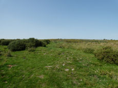
Notes: "A standing stone and triple stone row lying in a secluded position, across the head of a shallow, north facing valley. It measures 147 metres long with rows on average 1.5 m apart. The stones, fifty three of which were located, have a maximum height of 0.2 m and are spaced about 1.1 m apart, each opposite the stone of the adjacent row. There is also a possible former standing stone which is now recumbent." See also MDV129985
Nearby sites: SX 67431 71042
Distance: 3.25km
Holne Moor (N) Stone Ring Cairn Circle
OS Map: SX 6809 7162
HER: MDV26266
Megalithic Portal: 45830
ShortName: RC:HolneMoor N
Turner: A16
Notes: "Possible cairn in corner of a field." "Stone ring 9.5m diam internally, with bank 1.2m wide and 0.4m high. Joined on w side by reave (turner)." No NMR record.
Nearby sites: SX 6809 7162
Distance: 2.46km
Holne Ridge Stone Row
OS Map: SX 66741 71080
HER: MDV61453
Megalithic Portal: 27341
The Stone Rows of GB: Holne Ridge
PMD: Holne Ridge Stone Row
Alternate name: Holne Ridge North Stone Row
ShortName: SR Holne Ridge
Butler map: 60.26
DPD page: 90
Notes: "One or two cairns and a short probably unfinished stone row lie in the north west facing hollow above Horse Ford on the O Brook. The cairn described by Authority 2 lies at the south end of the site with the surviving stones of the stone row to the north. As so few stones survive the exact form and extent of the rows is impossible to determine but there may have been as many as three parallel rows approximately 1.0 metre apart. Overlying or abutting the east row at SX 6672 7109 is a low turf covered mound 3.0 metes in diameter and 0.4 metres high. It is not clear whether this feature forms part of the monument or if it is associated with the shallow turf cuttings to the east."
Nearby sites: SX 66741 71080
Distance: 3.90km
Holne Ridge N. Cist
OS Map: SX 66641 71138
HER: MDV12997
Megalithic Portal: 45800
PMD: Holne Ridge N.
Alternate name: Holne Ridge N.3 Cist
ShortName: CT HolneRidg 3
Butler map: 60.26.3
DPD page: 91
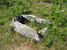
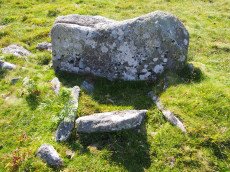
Notes: Butler Cist 3 Vol. 4. Map 60.26 (diagram p.195). "A probable but unusual cist is on steep well drained, NW facing slope. It utilizes the south east side of a massive slab, 1.6m long, 0.4m thick and 0.7m high, with smaller slabs 0.6m to 0.9m long and 0.2m thick, which barely project above ground level". NW of of Holne Ridge stone row. Lethbridge p.90-91, diagram p.90, photo bottom p.91
Nearby sites: SX 66641 71138
Distance: 3.98km
Horns Cross Stone Ring Cairn Circle
OS Map: SX 66921 71125
HER: MDV6475
Megalithic Portal: 27342
Alternate name: Holne Ridge N.6 Stone Ring Cairn Circle
ShortName: RC:HolneRidg 6
Butler map: 60.26.6
DPD page: 90
Grinsell: HOL 3
Turner: A35
Notes: "Remains of cairn; one of eight cairns forming part of a cairn cemetery on Holne Ridge. Truncated cairn, or ring cairn, gap in north-east. Diameter 14 metres, height 0.3 metres."
Nearby sites: SX 66921 71125
Distance: 3.71km
Horns Cross N. Cairn
OS Map: SX 66941 71187
HER: MDV26276
Megalithic Portal: 27342
Alternate name: Holne Ridge N.5 Cairn
ShortName: CN HolneRidg 5
Butler map: 60.26.5
Grinsell: HOL 2
Notes: "A turf and bracken covered Bronze Age cairn forming part of a cairn cemetery on Holne Ridge. The mound measures 14 metres by 14.4 metres in diameter and standing to a height of 1.4 metres. " Butler cairn 5 map 60.15. UPDATE 03/01/2023 This record formerly linked with MDV12975 which has been deleted.
It is unclear but this record now realte to MDV26276 which is a "tin-working spoil dump".
Nearby sites: SX 66941 71187
Distance: 3.68km
Huccaby Rings Inner Enclosed Settlement
OS Map: SX 6582 7381
HER: MDV6405
Megalithic Portal: 4616
ShortName: ES HuccabyInn
Notes: "Huccaby Ring a circular banked enclosure south-east of Huccaby Tor; smaller than Outer Huccaby Ring that lies to the north-west of the Tor. A Bronze Age enclosure visible as a turf covered stoney bank measuring 3.5 metres wide and stading to a maximum height of 0.7 metres. There is no obvious sign of an entrance."
Nearby sites: SX 6582 7381
Distance: 4.98km
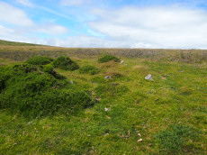
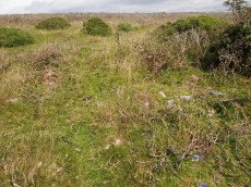
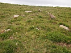
Mardle Embanked Cairn Circle
OS Map: SX 67526 69359
HER: MDV5308
Megalithic Portal: 3374
Alternate name: Mardle Valley 1 Embanked Cairn Circle
ShortName: CC Mardle 1
Butler map: 58.12.1
Turner: B11
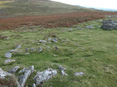
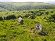
Notes: Turner: Embanked stone circle; an annular bank of earth and/or stone with an inner edge of orthostats. Much disturbed. Internal diam 6.5m with bank 1.2m wide and 0.4m high. This cairn has a very interesting structure appearing to be multiple circles of stones similar to the cairns at Corringdon Ball. This structure is difficult to capture in a photograph as the stones are small and the site much disturbed.
HER: A flat-topped cairn with a disturbed bank around its crest lies on a moderate south-west slope above the left bank of the River Mardle. The feature is circular, 11.8 metres in diameter, and stands a maximum of 0.8 metres high. The stoney ring measures 1.2 metres wide and 0.3 metres high and there are no traces of a cist or kerb in the main structure. The source of the disturbance is unclear though there does not appear to have been an excavation.
This cairn has been cleared of vegetation by the DPA in September 2025 and the author visited shortly afterwards on 02/10/2025. The main photo is from 15/07/2016 and the secondary photo was taken after the recent clearance work. The grid reference taken on 02/10/2025 was SX 67524 69358 which is a close match to the retained one from 2016.
Nearby sites: SX 67526 69359
Distance: 4.05km
Tunhill Rocks Settlement
OS Map: SX 732 758
HER: MDV7438
Megalithic Portal: 31984
ShortName: ST:TunhillRock
Nearby sites: SX 732 758
Distance: 4.57km
Wittaburrow Cairn
OS Map: SX 73353 75214
HER: MDV7537
Megalithic Portal: 32069
Alternate name: Wittaburrow 1 Cairn
ShortName: CN:Wittaburr 1
Butler map: 9.9.1
Grinsell: WID 15
Notes: "A large stony round cairn, south of Wittaburrow. The mound has a 25 metre diameter at base, but the structure has been much altered, probably robbed, and is now quite low in places. A ‘bite-shaped’ section is missing from the main mound on the south-eastern side where a smaller cairn, which is unlikely to be an original feature, stands within the original spread of the monument. Two large hollows have been dug into the main mound which, overall, survives in a very uneven state."
Nearby sites: SX 73353 75214
Distance: 4.22km
Yar Tor Stone Row
OS Map: SX 68177 73857
HER: MDV6459
Megalithic Portal: 2199
The Stone Rows of GB: Yar Tor
PMD: Yar Tor Stone Row
ShortName: SR Yar Tor
Butler map: 14.11
DPD page: 122
Barrow Report: 56
Notes: "The remains of a probable triple stone row with a cairn and cist at its south end and a barrow at its north. The row comprises stones set 2m apart and standing to a height of 0.3m. Some are concealed beneath the turf. The cairn measures 11m in diameter and 0.3m high with a central cist surrounded by a kerb. The barrow is 6m in diameter and 1m high". Lethbridge Corndon Triple Row pp.122-3. See also: Sea Views at Yar Tor Breton p.84
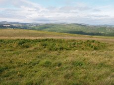
The author attempted to walk the stone row on 25/09/2025. The photo from 15/07/2016 shows the row in a grassy terrain but today the area is dense with gorse making most of the row buried and impassable.
Nearby sites: SX 68177 73857
Distance: 2.91km

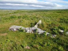
Yar Tor (Money Pit) Platform Cairn Circle and Cist
OS Map: SX 68181 73865
HER: MDV6460
Megalithic Portal: 1369
PMD: Money Pit
Alternate name: Money Pit Platform Cairn Circle and Cist
ShortName: CT Money Pit
Butler map: 14.11
Butler Vol 5: p.23 & Fig.4
DPD page: 122
Grinsell: WID 21
Turner: E51
Barrow Report: 56 62
Notes: "The south cairn is a very spread and slight earthwork with a centrally placed cist. Only the north and west side slabs of the cist remain in situ though a misplaced slab lies to one side of the chamber. Eleven slabs forming a kerb of approximately 3m surrounding the cist remain in situ. Several additional stones survive, protruding just above the surface of the flattened cairn, which are likely to be evidence of an outer circle with a diameter of approximately 11m". Lethbridge diagram p.122 and photo bottom p.122. Butler Money Pit - Vol. 1. Map 14.11 (photo on p.92, diagram pp.125-6).
Nearby sites: SX 68181 73865
Distance: 2.91km
Yar Tor Prehistoric Homestead Round House
OS Map: SX 674 734
HER: MDV26473
Megalithic Portal: 22983
ShortName: HC:YarTor
Nearby sites: SX 674 734
Distance: 3.36km

Yar Tor Summit Cairn
OS Map: SX 67865 73943
HER: MDV6434
Megalithic Portal: 11065
Alternate name: Yar Tor summit Cairn
ShortName: CN:Yar Tor Sum
Butler map: 14.8
Grinsell: WID 20
Barrow Report: 56
Notes: "Large cairn (approximately 18.0 metres) built on the summit of Yar Tor; the stones have been rearranged to form a shelter. This cairn is aligned with a reave; part of the Dartmeet parallel reave system."
Nearby sites: SX 67865 73943
Distance: 3.21km