
Prehistoric sites within 5km of SX 71792 84763
Guidance for walkers: The monuments featured in this database are archaeological treasures and need to be protected and preserved - please do not disturb any sites. Please check access and firing times before visiting sites, not all sites listed are on open access land. Firing ranges and boundaries of open access areas are marked on the OL28 OS Dartmoor Explorer map. Please stick to the country code and consider giving support to the numerous agencies that help to keep Dartmoor a fabulous natural and historic environment!
About the database listings: In all listings clicking on the photo or the site name will open a page for the site with a larger photo and further details from the database. The database now has over 6680 records covering nearly all publicly listed sites on Dartmoor including around 4800 round houses. This level of detail is of interest to archaeologists but tends to swamp listings of sites more likely to be of interest for walkers. For this reason, the listings default to around 550 core sites only. These are the stone circles, stone rows and the ring cairns listed by Turner. The default search radius is 2 km. The controls below the map can be used to start a new search by entering a 6- or 8-digit reference (without the prefix "SX"). The search radius can be specified and you can add incremental Display layers of detail on top of the core sites. If using a more detailed layer you will need to decrease the search radius to avoid getting hundreds of search results.
- Core sites Default listing of core sites consisting of stone circles & rows and some of the major ring cairns.
- Plus cairns adds approx. 1000 cairns and other minor sites not included in the core listings but excluding round houses.
- Plus round houses adds approx. 4800 round houses.
- Plus non-sites adds in the records for sites that no longer exist or are not prehistoric sites.
- Plus duplicates adds records excluded as duplicates. Those maybe duplicate records in external listings (e.g. the Historic Environment Records). For example, some sites have been identified as cairns in some listings and interpreted as round houses in other listings and both records appear.
These listings have incorporated, matched up and merged all of the records from all of the major archaeological listings including: Worth, Grinsell, Turner, Butler, Bill Radcliffe, Sandy Gerrard, Megalithic Portal, the National Monument Records and the Historic Environment Records. The author would like to thank Bill, Sandy, the lovely people both at Megalithic Portal (especially Anne Tate who did an amazing job to link listings) and at ACE Archaeology for collaborative work over the years to synchronise and correct listings across the various websites which now interlink. A culmination of years of work the final merger of cairn records took 3 months of cross referencing in 2017 the result being a snapshot of the records at that time. This data has in turn been refined since by field work and research. The round house data was supplied by Sandy Gerrard. Grid references are in order of accuracy: from Google Earth satellite, if visible and found, from a Garmin GPS reading, if visited by the author and from the literature otherwise. Individual site pages will state the source of the grid reference and provide satellite imagery. If a site listing lacks a photo it has not yet been visited by the author in which case the grid reference is from the literature.
Currently the database only includes sites which can be represented by a grid reference. Reaves are not included as they require GIS shape technology which is beyond the current capability of this system. To see the sources for the records, look at the tables on the resources menu. The database listings can also be viewed on a Google map and downloaded as GPS datasets for Garmin devices.
Corrections, or any feedback or suggestions are very welcome, email: info@dartmoorwalks.org.uk.
NOTE: Clicking on the icons for each monument in the map will give the name of the site. You can zoom in and out and drag the map around.
List of sites within 5km of SX 71792 84763
Leapra Rings Enclosure
OS Map: SX 700 826
HER: MDV26675
ShortName: EN:Leapra
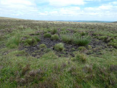
Notes: HER: Leapra Rings consists of three possibly Prehistoric circular features on Shapeley Common
Butler: Leapra Rings on steeply sloping ground on Shapley Common consist of three roughly circular banks levelled into the hillside. They are 10 - 12 metres in daimeter and over a metre high in places. About a third of the periphery is missing from the northern ring, perhaps not an original feature as neither of the orhters now has any visible entrance and their purposes is uncertain as they are too large for huts. A few slabs set edgeways show above the truf covered banks, occasionally paired and infilled with smaller stones in typically Prehistoric fashion.
Butler continues: Another enigmatic site lies in the second field to the north, on a good settlement site just above the damp ground surrounding the Leapra Brook. The overgrown remains are almost unrecognizable but appear to be of prehistoric construction like those above, perhpas a hut with a small paddock attached.
See also entries for round houses all of which are associated with the same HER entry: Shapley Tor N (SiteID=8275), Shapley Tor N (SiteID=8276) and Shapley Tor N (SiteID=8277)
Nearby sites: SX 700 826
Distance: 2.81km
Berry Pound
OS Map: SX 71325 80349
HER: MDV8754
ShortName: PD:Berry
Notes: Berry Pound a Prehistoric enclosure on Hamel Down
Nearby sites: SX 71325 80349
Distance: 4.44km
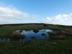
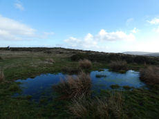
Birch Tor Ancient Pool
OS Map: SX 68686 81656
HER: MDV127183
ShortName: PO:Birch Tor
Notes: "The pool at Birch Tor measures around 15.5m. One of over 40 such 'sacred' pools identified on Dartmoor that are thought to have potentially been designed during the prehistoric period."
Nearby sites: SX 68686 81656
Distance: 4.39km
Birch Tor Cairn
OS Map: SX 68686 81654
HER: MDV6673
Megalithic Portal: 34981
Alternate name: Birch Tor Summit Cairn
ShortName: CN:Birch Tor
Butler map: 24.4
Grinsell: N.BOV 1
Barrow Report: 56
Notes: "The heavily disturbed remains of a large, flat-topped cairn lie on the ridge crest 230 metres north of Birch Tor. The centre and south margin of this feature have apparently suffered from an unrecorded excavation with spoil dumped to the south and on the east fringe of the mound. Two large upright slabs are embedded in the unexcavated interior of the cairn and may have previously been interpreted as elements of a kerb even though they lie several metres in from the actual edge of the feature. 10m to the north-west of the cairn is a warren boundary stone inscribed with the letters`WB'on its eastern side."
Nearby sites: SX 68686 81654
Distance: 4.39km
Bush Down Settlement
OS Map: SX 6849 8217
HER: MDV6596
Megalithic Portal: 7699
ShortName: ST:BushDown
Nearby sites: SX 6849 8217
Distance: 4.20km

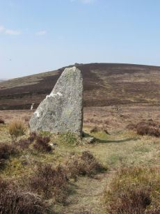
Butterdon Hill (nr. Moretonhampstead) Standing Stone
Prehistoric Dartmoor Walks: Dartmoor Walk: Butterdon Hill (nr Moretonhampstead) Standing Stone
OS Map: SX 74784 88403
HER: MDV8278
Megalithic Portal: 33950
PMD: Butterdon Down Standing Stone
Alternate name: Butterdon Down Standing Stone
ShortName: SS Butter Down
Notes: Standing stone - prob. prehistoric. An upright stone, stands at the west edge of Butterdon Down, Moretonhampstead, beside the public footpath, 600 yards from Cranbrook Farm. It is between six and seven feet high and of slightly curved slab shape. Ref: Devon & Cornwall Notes & Queries 31 1970 pp. 225-26.
HER quoting Turner: Standing stone measuring over 2.0 meters in height located on the line of a public footpath at SX74778839. This stone may be standing on a cairn.
Nearby sites: SX 74784 88403
Distance: 4.71km

Challacombe Down Cairn Circle
Prehistoric Dartmoor Walks: Dartmoor Site: Challacombe Down Triple Stone Row
OS Map: SX 6898 8084
HER: MDV49462
Megalithic Portal: 1819
PMD: Challacombe Down Stone Row
ShortName: CC Challacombe
Butler map: 24.3
Butler Vol 5: p.239 & Fig.169
Turner: G20
Notes: Dubious site - the current arrangement relates to stones placed during restoration of the stone row. See Worth (1953) p. 226 on how "nothing coherent" came of attempts to re-erect stones scattered to the west of the north end of the row which gave the appearance of a stone circle.
Nearby sites: SX 6898 8084
Distance: 4.83km
Challacombe Down Standing Stone
Prehistoric Dartmoor Walks: Dartmoor Site: Challacombe Down Triple Stone Row
OS Map: SX 69021 80723
HER: MDV6600
Megalithic Portal: 10092
PMD: Challacombe Stone Row
ShortName: SS Challacombe
Butler map: 24.3
DPD page: 126
Notes: The largest and most prominent blocking stone of the Dartmoor rows is to be found at the Challacombe triple row. Worth states that it is over 5 feet in width at the base and over 6 feet in height. Butler (Vol. 2) states that the terminal pillar is today 0.5m shorter than when it was measured in 1893.
Nearby sites: SX 69021 80723
Distance: 4.90km
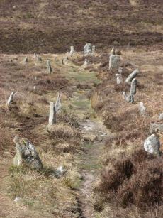
Challacombe Down Stone Row
Prehistoric Dartmoor Walks: Dartmoor Site: Challacombe Down Triple Stone Row
OS Map: SX 69016 80718
HER: MDV6600
Megalithic Portal: 1819
The Stone Rows of GB: Challacombe Down
PMD: Challacombe Stone Row
ShortName: SR Challacombe
Butler map: 24.3
Butler Vol 5: p.239 & Fig.169
DPD page: 126
Notes: "Bronze Age triple stone row well marked and wider apart at the north, drawing nearer to the south where they meet a blocking stone of unusual size. The stones have suffered little in their restoration except that a stone in the middle row was turned to form a blocking stone for that row. The loose stones scattered to the west of the north end have been suggested to form a stone circle and additional rows but may be stones excavated from the north end of the stone row." Breton p.41-42
Nearby sites: SX 69016 80718
Distance: 4.91km
Cranbrook Castle Fort
Prehistoric Dartmoor Walks: Dartmoor Walk: Butterdon Hill (nr Moretonhampstead) Standing Stone
OS Map: SX 73858 89023
HER: MDV8221
Megalithic Portal: 4624
ShortName: FT Cranbrook
Notes: "The outer rampart cuts or overlies the banks of an earlier field system. Upwards of 30 clearance cairns are visible in the interior; date unknown. The outer defences on the east and west sides are clearly incomplete. On the north side the inner rampart line is marked by 2 very low linear dumps of stone, which appear to have acted as markers for the front and rear of the rampart. No trace of an accompanying ditch. The original bivallate plan of the hillfort is reinforced by the abrupt termination on the west side of both the outer bank and inner bank and ditch in line. Other aspects of the unfinished hillfort are the irregularities in height of inner rampart on the south side. These probably mark divisions between construction gangs."
Nearby sites: SX 73858 89023
Distance: 4.73km
Cripdon Ancient Pool
OS Map: SX 73345 80335
HER: MDV127204
ShortName: PO:Cripdon
Notes: "The pool at Cripdon measures 24 by 14m One of over 40 such 'sacred' pools identified on Dartmoor that are thought to have potentially been designed during the prehistoric period"
Nearby sites: SX 73345 80335
Distance: 4.69km
Easdon A Ancient Pool
OS Map: SX 73212 82349
HER: MDV127207
ShortName: PO:Easdon A
Notes: "Easdon A measures 12.5 by 10m One of over 40 such 'sacred' pools identified on Dartmoor that are thought to have potentially been designed during the prehistoric period"
Nearby sites: SX 73212 82349
Distance: 2.80km
Easdon B Ancient Pool
OS Map: SX 73222 82334
HER: MDV127208
ShortName: PO:Easdon B
Notes: "A pool measuring 9 by 6.5m. One of over 40 such 'sacred' pools identified on Dartmoor that are thought to have potentially been designed during the prehistoric period. Lies near a reave."
Nearby sites: SX 73222 82334
Distance: 2.82km
Easdon Hill Stone Ring Cairn Circle
OS Map: SX 73358 82318
HER: MDV8767
Megalithic Portal: 45848
PMD: Easdon Tor
ShortName: RC:Easdon Hill
Butler map: 22.3
Grinsell: MAN 1
Turner: A61
Notes: HER: A cairn with a large centrally placed rock which is possibly the capstone of a kist. Robbers have excavated around and about this giving a rock strewn central hollow to the cairn. There is no encircling ditch. The capstone is approximately square. Touching its base at the east is a triangular shaped orthostat. The cairn is situated on the very summit of a hill.. HER referring to Turner: Turner identifies this site as a ring cairn. Internal diameter 6 metres, with bank 2.5 metres wide and 1 metre high ... Encircles a natural boulder, 2.8 metres wide, 1.6 metres thick and up to 2.5 metres high. Reave on north-western side.
Nearby sites: SX 73358 82318
Distance: 2.90km
Grimslake Platform Cairn Circle and Cist
OS Map: SX 70414 81166
HER: MDV8744
Megalithic Portal: 44533
The Stone Rows of GB: Grimslake Cist
PMD: Hookney Down
Alternate name: Grimslake Mire Platform Cairn Circle and Cist
ShortName: CT Grimslake
Butler map: 20.16
Butler Vol 5: p.219 & Fig.153
DPD page: 128
Grinsell: N.BOV 3
Turner: E18
Notes: Cairn with kerb circle and central cist. Lethbridge diagram p.127 and photo top p.128. Butler Grimslake Mire - Vol. 1. Map 20.16 (diagram p.147).
Nearby sites: SX 70414 81166
Distance: 3.85km
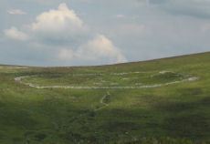
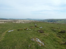
Grimspound Enclosed Settlement
Prehistoric Dartmoor Walks: Dartmoor Site: Grimspound Enclosed Settlement
OS Map: SX 70073 80909
HER: MDV8778
Megalithic Portal: 1344141065
ShortName: ES Grimspound
DPD page: 127
Notes: Probabaly the best known enclosed settlement on Dartmoor, within walking distance of Warren House Inn. "Prehistoric enclosed settlement with a substantial granite surrounding wall, containing 24 hut circles, as well as several 'pens' built into the enclosure wall, positioned in a valley between Hookney Tor and Hameldon. First planned by A. C. Shillibeer in 1829, this site was excavated by the Dartmoor Exploration Committee in 1894-5. Within the guardianship area managed by Dartmoor National Park Authority". Extensive notes on the HER record, see also coverage on Wikipedia and Legendary Dartmoor.
Nearby sites: SX 70073 80909
Distance: 4.22km
Hameldown N.E. Stone Row
OS Map: SX 71481 80095
HER: MDV18865
Megalithic Portal: 6333472
The Stone Rows of GB: Hameldown
PMD: Berry Pound Stone Row
Alternate name: Hamel Down Stone Row
ShortName: SR Hamel NE
Butler map: 20.3
Notes: No NMR listing. HER record MDV18865. Described in Butler Volume 1 Map 20.3. To the south of Berry Pound is a small longhouse. "Within the abandoned field 250m south of the longhouse are the probable remains of a single row first recorded in 1983. Five or six stones remain in line up to 206m apart, the rest having been removed or buried when the field was ploughed."
Nearby sites: SX 71481 80095
Distance: 4.68km
Hameldown Tor Cairn
OS Map: SX 70318 80574
HER: MDV8768
Megalithic Portal: 16628
ShortName: CN HameldonTor
Butler map: 20.8
Butler Vol 5: p.166 & Fig.106
Grinsell: MAN 2
Turner: E54
Notes: Cairn on hameldown tor.(diam 14m. Heig 700mm)a denuded cairn with kerb of large stones on northern half only. Pillar and conical mound of small stones of evidently modern date. Remainder of kerb visible (11 stones). Remainder of cairn largely grassed over but head sized granite boulders visible (os trig. Point and recent mound of stones on top). Butler Volume 1 Map 20.8.
Nearby sites: SX 70318 80574
Distance: 4.44km
Heath Stone Standing Stone
Prehistoric Dartmoor Walks: Dartmoor Site: Hurston Ridge Double Stone Row
OS Map: SX 67133 83755
HER: MDV6650
Megalithic Portal: 14933
ShortName: SS Heath Stone
Butler map: 25.
Notes: The original Heath Stone was a boundary stone which was referred to in the Perambulation of the Forest of Dartmoor in 1240 and some very early maps. According to Butler (Vol. 2 Map 25 p.32) the stone carved with a biblical inscription in 1970 that is currently known as the Heath Stone is unlikely to have been the original Heath Stone as it is in a useless position to be of any use as a boundary stone. The stone was not included in maps from the 18th century and then reappeared in a different location. It is doubtful that the current stone is the original or that it is prehistoric. Crossing suggests that the large standing stone in the Hurston Ridge stone row is the actual Heath Stone. See also, Legendary Dartmoor: The Dartmoor Heathstone
Nearby sites: SX 67133 83755
Distance: 4.77km
Hookney Tor Cairn
OS Map: SX 69905 81314
HER: MDV6611
Megalithic Portal: 34982
Alternate name: Hookney Tor summit Cairn
ShortName: CN HookneyTor
Butler map: 20.7
Grinsell: N.BOV 2
Notes: Tor cairn north of Hookney Tor and resembling a barrow in shape. Enough of the topsoil has been removed to show that the mound is a natural outcrop feature covered with turf and heather, enclosed on three sides by a broken turf and stone bank. A footpath approaching the west side has probably effaced the remainder of the circuit.
Nearby sites: SX 69905 81314
Distance: 3.93km

Hookney Tor North A Ancient Pool
OS Map: SX 69843 81721
HER: MDV127212
ShortName: PO HookneyTorA
Notes: "A pool measuring 15 by 9.5m. One of over 40 such 'sacred' pools identified on Dartmoor that are thought to have potentially been designed during the prehistoric period. Lies near a prehistoric cairn."
Nearby sites: SX 69843 81721
Distance: 3.61km
Hookney Tor North B Ancient Pool
OS Map: SX 69838 81605
HER: MDV127213
ShortName: PO HookneyTorB
Notes: "A pool measuring 7.5m. One of over 40 such 'sacred' pools identified on Dartmoor that are thought to have potentially been designed during the prehistoric period."
Nearby sites: SX 69838 81605
Distance: 3.71km
Hunters Tor Fort
Prehistoric Dartmoor Walks: Dartmoor Resource: Table of Devon Iron Age Forts
OS Map: SX 76158 82443
HER: MDV8824
Megalithic Portal: 7759
ShortName: FT HuntersTor
Notes: "Iron Age hill-fort at Hunters' Tor: 'Three concentric enclosures, defences stone built and partly robbed for field walls. Inner entrance knobbed with embanked approach-road across second enclosure. Hill-top site.'"
Nearby sites: SX 76158 82443
Distance: 4.94km
Hurston Ridge Settlement
OS Map: SX 674 825
HER: MDV6668
Megalithic Portal: 34979
ShortName: ST Hurston
Butler map: 25.9
Nearby sites: SX 674 825
Distance: 4.94km
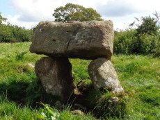
Meacombe Cist
OS Map: SX 72500 86909
HER: MDV8231
Megalithic Portal: 10518
PMD: Meacombe Chambered Cairn
ShortName: CT Meacombe
Butler Vol 5: p.155 & Fig.94
DPD page: 148
Grinsell: A:CHA 1
Barrow Report: 49
Notes: Sometimes referred to as a chambered tomb due to the enormous size of the cover slab but it is more likey a cist. Butler Meacombe Cist Vol. 5. (diagram p.155).
Nearby sites: SX 72500 86909
Distance: 2.26km
Nattadon Fort
Prehistoric Dartmoor Walks: Dartmoor Resource: Table of Devon Iron Age Forts
OS Map: SX 70510 86638
HER: MDV8261
Megalithic Portal: 43578
ShortName: FT:Nattadon
Notes: "Remains of a hillfort 200 meters south of Nattadon Farm." "Constructed in a naturally defensive situation, the earthworks appear to be the setting out stage of a bivallate hilltop fortification, similar to Hunters Tor. It appears to be constructed upon a pre-existing field system which is harder to see on the ground than on the aerial photograph. The present extent of the field system is around 12 hectares. The north-east side of outer defensive enclosure is hard to trace and may have been destroyed by tinners pits. There is no trace of an entrance visible."
Nearby sites: SX 70510 86638
Distance: 2.27km
Shapley Common Standing Stone
OS Map: SX 69992 82248
PMD: Shapley Common
ShortName: SS Shapley
Butler map: 23.5
Butler Vol 5: p.212
Notes: Possible standing stone, see Butler Vol V (1997) p 212.
Nearby sites: SX 69992 82248
Distance: 3.09km
Shapley Common Round House
OS Map: SX 6942 8206
HER: MDV6553
Megalithic Portal: 45859
ShortName: HC:ShapleyComm
DPD page: 128
Notes: Lethbridge p.128 Hut Circle on Shapley Common - particularly fine example.
Nearby sites: SX 6942 8206
Distance: 3.60km
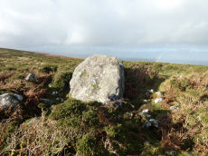
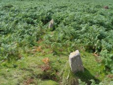
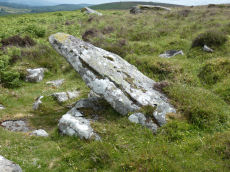
West Vitifer Cist
OS Map: SX 67575 82802
HER: MDV6615
Megalithic Portal: 34980
PMD: Chagford Common
ShortName: CT WestVitif 1
Butler map: 25.11
Grinsell: CHA 4
Barrow Report: 16
Notes: "Possible location of a Bronze Age cist, although when subject to field investigation in November 2002 the site was not found" "The cairn was partially excavated in 1897 by the Barrow Committee of the Devonshire Association. This working revealed a ring of slabs surrounding a cist which had not been previously examined. In the cist there was a complete Bronze Age beaker together with charcoal but no trace of a burial." Cairn survives, restored urn thought to be in Plymouth museum. See: Sixteenth Barrow Report 1897. Butler Vol. 2. Map 25.11 ( p.32).
The author visited this site on 10 May 2024. I took photos of a possible candidate but I was unconvinced I had located the site so a wide search was undertaken of the vicinity within approx. 100 m. My initial conclusion is that the site cannot be located. However, as a desktop exercise on 23/05/24 I'm inclined to think I had actually located it. It is the dip behind the stone which appears on the RHS of the photo. This coincides within a very short distance with the location I had previously determined using satellite and also to the location given in the scheduled monument SX 67571 82800.
Nearby sites: SX 67575 82802
Distance: 4.65km

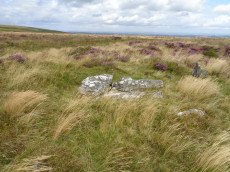
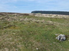
Yardworthy Stone Row
OS Map: SX 67605 84395
HER: MDV61337
Megalithic Portal: 6333471
The Stone Rows of GB: Yardworthy
PMD: Yardworthy
ShortName: SR Yardworthy
Notes: Quinnell quoted on HER: Stone row in Yardworthy Newtake, an area of rough pasture that has since undergone some stone clearance. Apparently the remains of a double row it starts 3.0 metres from a low barrow at SX67608438 and extends to the north-east for 7.0 metres. The north-west side consists of four stones, 2.0 to 2.5 metres apart. The south-eastern side about 1.4 metres distant has only one stone and two turf humps which may conceal others. Visible stones are barely 0.1 metres high. Immediately beyond the north-east end is a hollow or stone pit about 4.0 by 2.0 metres diameter. This, and clearance in the area may have destroyed any continuation.
The stones of the row are around 20 cm in length and almost impossible to photograph as a collection. There is a goood plan to the site on the Stone Rows of great Britain linked in the listings above.
The site was visited by the author and Steve Szypko on 03/03/2025 and we found 3 of the 4 stones reportedly visible - the other may have been under surface water. It is almost impossible to capture these small stones in one photo so a montage of 4 photos is linked to this record; the cairn and the 3 stones found. The cairn and row was difficult to find.
The stones of the stone row stones were recorded on a Garmin GPS device at: SX 67605 84398, SX 67605 84395, SX 67606 84395. The cairn is centred at SX 67601 84390.
Nearby sites: SX 67605 84395
Distance: 4.20km