
Prehistoric sites within 2km of SX 62600 66000
Guidance for walkers: The monuments featured in this database are archaeological treasures and need to be protected and preserved - please do not disturb any sites. Please check access and firing times before visiting sites, not all sites listed are on open access land. Firing ranges and boundaries of open access areas are marked on the OL28 OS Dartmoor Explorer map. Please stick to the country code and consider giving support to the numerous agencies that help to keep Dartmoor a fabulous natural and historic environment!
About the database listings: In all listings clicking on the photo or the site name will open a page for the site with a larger photo and further details from the database. The database now has over 6680 records covering nearly all publicly listed sites on Dartmoor including around 4800 round houses. This level of detail is of interest to archaeologists but tends to swamp listings of sites more likely to be of interest for walkers. For this reason, the listings default to around 550 core sites only. These are the stone circles, stone rows and the ring cairns listed by Turner. The default search radius is 2 km. The controls below the map can be used to start a new search by entering a 6- or 8-digit reference (without the prefix "SX"). The search radius can be specified and you can add incremental Display layers of detail on top of the core sites. If using a more detailed layer you will need to decrease the search radius to avoid getting hundreds of search results.
- Core sites Default listing of core sites consisting of stone circles & rows and some of the major ring cairns.
- Plus cairns adds approx. 1000 cairns and other minor sites not included in the core listings but excluding round houses.
- Plus round houses adds approx. 4800 round houses.
- Plus non-sites adds in the records for sites that no longer exist or are not prehistoric sites.
- Plus duplicates adds records excluded as duplicates. Those maybe duplicate records in external listings (e.g. the Historic Environment Records). For example, some sites have been identified as cairns in some listings and interpreted as round houses in other listings and both records appear.
These listings have incorporated, matched up and merged all of the records from all of the major archaeological listings including: Worth, Grinsell, Turner, Butler, Bill Radcliffe, Sandy Gerrard, Megalithic Portal, the National Monument Records and the Historic Environment Records. The author would like to thank Bill, Sandy, the lovely people both at Megalithic Portal (especially Anne Tate who did an amazing job to link listings) and at ACE Archaeology for collaborative work over the years to synchronise and correct listings across the various websites which now interlink. A culmination of years of work the final merger of cairn records took 3 months of cross referencing in 2017 the result being a snapshot of the records at that time. This data has in turn been refined since by field work and research. The round house data was supplied by Sandy Gerrard. Grid references are in order of accuracy: from Google Earth satellite, if visible and found, from a Garmin GPS reading, if visited by the author and from the literature otherwise. Individual site pages will state the source of the grid reference and provide satellite imagery. If a site listing lacks a photo it has not yet been visited by the author in which case the grid reference is from the literature.
Currently the database only includes sites which can be represented by a grid reference. Reaves are not included as they require GIS shape technology which is beyond the current capability of this system. To see the sources for the records, look at the tables on the resources menu. The database listings can also be viewed on a Google map and downloaded as GPS datasets for Garmin devices.
Corrections, or any feedback or suggestions are very welcome, email: info@dartmoorwalks.org.uk.
NOTE: Clicking on the icons for each monument in the map will give the name of the site. You can zoom in and out and drag the map around.
List of sites within 2km of SX 62600 66000
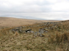
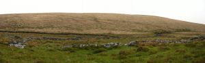
Brown Heath Enclosed Settlement
OS Map: SX 64080 65389
HER: MDV5135
Megalithic Portal: 14936
ShortName: ES Brown Heath
DPD page: 74
Barrow Report: 38
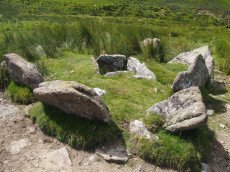
Notes: "A fine example of an enclosure. The walling consisting of very large stones reaching a height of one metre. It contains three hut circles and a number of courts situated mainly on its north and western sides. There is no obvious entrance." Lethbridge p. 74, diagram p.71. Hook Lake on Megalithic Portal.
Nearby sites: SX 64080 65389
Distance: 1.60km
Brown Heath (Hook Lake) Encircled Cairn and Cist
OS Map: SX 64114 65327
HER: MDV5137
Megalithic Portal: 52166
The Stone Rows of GB: Hook Lake
PMD: Hook Lake Stone row
Alternate name: Hook Lake stone row Encircled Cairn and Cist
ShortName: CT Hook Lake
Butler map: 55.8
DPD page: 74
Grinsell: HAR 3
Turner: F11
Barrow Report: 38
Notes: "A double stone row, on Brown Heath, circa 540 feet in length, direction of length N 10o E. At the north end is a stone circle, diameter 31 feet, surrounding a cairn which contains the remains of a cist." Ruined and possibly no longer visible. Butler Hook Lake stone row - Vol. 4. Map 55.8 (pp.78-9).
Nearby sites: SX 64114 65327
Distance: 1.66km
Brown Heath (Hook Lake) Stone Row
OS Map: SX 64112 65318
HER: MDV5136
Megalithic Portal: 1788
The Stone Rows of GB: Hook Lake
PMD: Brown Heath Stone Row
Alternate name: Hook Lake Stone Row
ShortName: SR Hook Lake
Butler map: 55.8
DPD page: 74
Barrow Report: 38
Notes: Worth: Brown Heath, Butler: Hook Lake. "On the southwest slopes of Brown Heath a double stone row 182.0m. long runs from a cairn circle at its northern and higher end to the east side of the enclosure (SX 66 NW 50) where it is overlaid by the enclosure wall. The point at which the southern end of the row ended is therefore not easily determined. The row does not point exactly to the centre of the cairn, but to about 2.0m. to the East. The eastern part of the row contains more stones than the western part, in which there are notable gaps. There are a few large stones, the largest being 1.0m. high and measuring 1.0m. x 0.7m., but most are relatively small, their average height being 0.5m". Lethbridge p.74, diagram p.71. See also: Sea Views at Hook Lake/
Nearby sites: SX 64112 65318
Distance: 1.66km
Deadmans Bottom D Platform Cairn Circle and Cist
Prehistoric Dartmoor Walks: Dartmoor Site: Guide to the Langcombe Brook & Deadman's Bottom Cists
OS Map: SX 6096 6673
HER: MDV5086
Megalithic Portal: 45731
PMD: Deadman's Bottom S 10
Alternate name: Langcombe Brook 10 Platform Cairn Circle and Cist
ShortName: CT:Deadmans D
Butler map: 50.3.10
DPD page: 45
Grinsell: SHA 10
Turner: E44
Barrow Report: 53
Notes: "The cairn is 5m in diameter by 0.3m high with a retaining kerb on its northern side. The cist is 0.8m long b 0.7m wide." "Cist (listed as 'D' by Worth) found at Deadman's Bottom Langcombe, by Mr Button. Internal dimensions, length 3 feet 8 inches, width 2 feet. The stones are barely visible above grass level. The cover stone is missing." Lethbridge p.45 Langcombe Cist E - diagram p.43. Butler Langcombe Brook Cairn 10 - Vol. 3. Map 50.3 (pp.148-54 general plan of Langcombe Brook cairns p.151, diagram of Langcombe cists p.153).
Nearby sites: SX 6096 6673
Distance: 1.80km
Deadmans Bottom E Cist
Prehistoric Dartmoor Walks: Dartmoor Site: Guide to the Langcombe Brook & Deadman's Bottom Cists
OS Map: SX 60984 66714
HER: MDV5122
Megalithic Portal: 45732
PMD: Deadman's Bottom S 9
Alternate name: Langcombe Brook 9 Cist
ShortName: CT Deadmans E
Butler map: 50.3.9
DPD page: 45
Grinsell: SHA 11
Barrow Report: 53
Notes: "Cist (Listed as 'E' by Worth) found at Deadman's Bottom, Langcombe, by Mr. Button. Probable original dimensions, length 2ft 2 ins, width 1ft. 5ins. The stones barely show above the surface and the cover-stone is missing." ... "A well defined cairn 6.0m in diameter and 0.4m high with a cist in the top. This stone-lined cist measures 0.7m by 0.5m internally and 0.3 deep. Two of the side stones have fallen inwards." Lethbridge p.45 Langcombe Cist F - diagram p.43 Butler Langcombe Brook Cairn 9 - Vol. 3. Map 50.3 (pp.148-54 general plan of Langcombe Brook cairns p.151, diagram of Langcombe cists p.153).
Nearby sites: SX 60984 66714
Distance: 1.77km
Deadmans Bottom F Platform Cairn Circle and Cist
Prehistoric Dartmoor Walks: Dartmoor Site: Guide to the Langcombe Brook & Deadman's Bottom Cists
OS Map: SX 61201 66983
HER: MDV5125
Megalithic Portal: 45733
PMD: Deadman's Bottom E.
Alternate name: Langcombe Brook 11 Platform Cairn Circle and Cist
ShortName: CT Deadmans F
Butler map: 50.3.11
DPD page: 43
Grinsell: SHA 12
Barrow Report: 53
Notes: "Cist (Listed as 'F' by Worth) found at Deadman's Bottom, Langcombe, by Mr. Button. The cover-stone is still in position but the cist appears to have been rifled, the end and side-stones having been displaced at the north-east and southwest angles. Original length would appear to have been 2 feet 10 inches, and the width 1 foot 7 inches. The greatest length of the cover-stone is 4ft 9 inches and its greatest width 3 feet 1 1/2 inches." ... "A flat-topped cairn measuring 5.4m in diameter and standing a maximum of 0.4m high. A well-preserved cist 1.3m long, 0.6m wide and 0.15m deep is largely obscured by the coverstone". Lethbridge p.43 Langcombe Cist A (Upper Deadman's Bottom) - diagram p.43. nb. Not listed by Turner - assigned as "Platform Circle" type cairn due to description in NMR. Butler Langcombe Brook Cairn 11 - Vol. 3. Map 50.3 (pp.148-54 general plan of Langcombe Brook cairns p.151, diagram of Langcombe cists p.153).
Nearby sites: SX 61201 66983
Distance: 1.71km
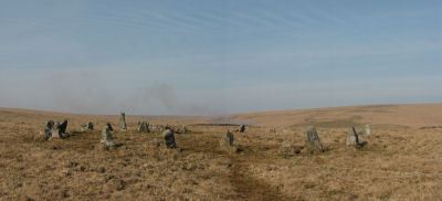
Erme Cairn Circle
Prehistoric Dartmoor Walks: Dartmoor Site: Upper Erme Stone Row & Cairn Circle
OS Map: SX 63517 64442
HER: MDV4310
Megalithic Portal: 533
Alternate name: Upper Erme stone row Cairn Circle
ShortName: CC The Dancers
Butler map: 55.7.1
DPD page: 71
Grinsell: COR 10
Turner: G16
Notes: An impressive cairn circle (often referred to as a stone circle) on Stall Moor which is also known as The Dancers, Kiss in the Ring or Stall Moor Circle. "Round barrow with retaining circle at south end of longest Dartmoor stone row. Diameter 16m, height of mound 0.3m." Lethbridge pp.70-71, diagram p.71
Nearby sites: SX 63517 64442
Distance: 1.81km
Erme Pound
Prehistoric Dartmoor Walks: Dartmoor Site: Upper Erme Stone Row & Cairn Circle
OS Map: SX 638 658
HER: MDV5110
Megalithic Portal: 14937
ShortName: PD Erme Pound
DPD page: 71
Notes: See also MDV5109
Nearby sites: SX 638 658
Distance: 1.22km
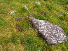
Erme Pound (Near) Cist
OS Map: SX 6392 6551
HER: MDV28585
Megalithic Portal: 45758
PMD: Erme Pound
ShortName: CT:Erme Pound
Grinsell: HAR 2
Turner: D29
Notes: "A prehistoric round cairn, 300 metres west of the River Erme in an area of intense peat cutting remains. The cairn has surviving elements of a kerb and a central hollow which may have contained a cist. This probable platform cairn has a diameter of 3.8 metres and is raised above ground by 0.5 metres. The flat-topped mound is surrounded by a closely fitting, though incomplete, kerb of upright slabs, where many of the survivors remain in situ. An elongated hollow across the centre of the cairn may represent a disturbed cist, and a displaced slab within the hollow is the remains of a capstone.". "Noted by Hankin in July 1976, perhaps in a small cairn diameter 3.7m and height 0.3m. It is now filled in and Grinsell failed to locate it, 'it seems never to have been planned if it ever existed.'" This cist was listed by Dixon in 1952 70th Barrow Report (T.D.A Vol 84) with Dixon #96. It is not listed in prior Barrow Reports - and appears towards end of Dixon's list, so presumably discovered/reported late 40s to 1952. Not listed by Butler (area covered in Vol. 4. Map 55). Not listed in Hankin's 'An archaeological check-list for Harford'.
Nearby sites: SX 6392 6551
Distance: 1.41km
Grim's Grave (S) Platform Cairn Circle and Cist
Prehistoric Dartmoor Walks: Dartmoor Site: Guide to the Langcombe Brook & Deadman's Bottom Cists
OS Map: SX 61251 66313
HER: MDV5126
Megalithic Portal: 14929
PMD: Langcombe Brook S.
Alternate name: Langcombe Brook 4 Platform Cairn Circle and Cist
ShortName: CT GrimsGraveS
Butler map: 50.3.4
Butler Vol 5: p.160
DPD page: 46
Grinsell: SHA 18
Turner: E8
Barrow Report: 50
Notes: Lethbridge p.46 Langcombe Cist H - diagram p.43. Butler Langcombe Brook 4 (Cairn 4) - Vol. 3. Map 50.3 (pp.148-54 general plan of Langcombe Brook cairns p.151, diagram of Langcombe cists p.153).
Nearby sites: SX 61251 66313
Distance: 1.38km
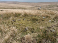
Grims Grave Ring Setting Cairn and Cist
Prehistoric Dartmoor Walks: Dartmoor Site: Guide to the Langcombe Brook & Deadman's Bottom Cists
OS Map: SX 61245 66422
HER: MDV5083
Megalithic Portal: 14930
PMD: Grim's Grave
ShortName: CT Grims Grave
Butler map: 50.3.3
DPD page: 46
Grinsell: SHA 13
Turner: D20
Barrow Report: 12 20 56
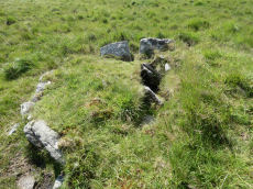
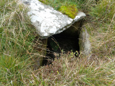
Notes: "A ring cairn set into the slope, c 4.5m in diameter, with a cist at its centre. The cairn consists of a stony, turf-covered mound contained by a ring of upright slabs, most leaning outwards, c 1m in height; the mound rises to c 0.4m at top of cist. The cist, box dimensions c 0.8m x 0.95m internally, is formed from edge-set slabs. One side slab is c 1.7m long, 0.9m wide and 0.2m thick. The monument survives in a very good condition though the cover-stone is missing - this is possibly the slab that now lies on the down-slope side." Lethbridge p.46 Langcombe Cist G (Grim's Grave) - diagram p.43. Butler Vol. 3. Map 50.3 Cairn 3 (pp.148-54 general plan of Langcombe Brook cairns p.151, diagram of Langcombe cists p.153, photo pp.94-96).
Nearby sites: SX 61245 66422
Distance: 1.42km
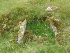
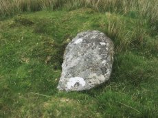
Knackersmill Gulf N. Cist
OS Map: SX 63390 65587
HER: MDV13185
Megalithic Portal: 45759
PMD: Stinger's Hill
ShortName: CT Stingers
Butler Vol 5: p.180 & Fig.122
DPD page: 73
Grinsell: COR 8
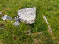
Notes: The NMR gives SX63376494 as the grid reference - this error is replicated in HER entry 28468. The author could not find a cist there. As PMD points out that is the location of Grinsell's CORNWOOD 9 cairn and not CORNWOOD 8. "A cist 1.20m. by 0.60m. with a close set retaining kerb circle 4.0m. in diameter is situated on Stinger's Hill opposite Erme Pound". Lethbridge Stingers Hill cist p.73. diagram p.71. Butler Map 55.7. (diagram Vol. 5. p.180). The author visited this site on 16/7/21 and the grid reference is confirmed as listed on this record.
Nearby sites: SX 63390 65587
Distance: 0.89km
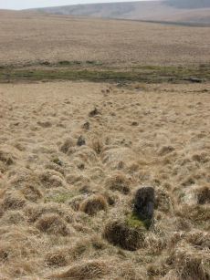
Langcombe (S) Platform Cairn Circle and Cist
Prehistoric Dartmoor Walks: Dartmoor Site: Guide to the Langcombe Brook & Deadman's Bottom Cists
OS Map: SX 60866 66155
HER: MDV5128
Megalithic Portal: 45729
PMD: Langcombe Brook 6
Alternate name: Langcombe Brook 6 Platform Cairn Circle and Cist
ShortName: CT Langcombe S
Butler map: 50.3.6
DPD page: 47
Grinsell: SHA 19
Turner: E23
Barrow Report: 50 52
Notes: "A cist, lying a little over 590 yds south west of Grim's Grave, within a flat topped cairn. Cist has two sides and the south end stone are in place and the cover stone rests in part over the cist". Lethbridge p.47 Langcombe Cist J - diagram p.43. Butler Langcombe Brook 6 (Cairn 6) - Vol. 3. Map 50.3 (pp.148-54 general plan of Langcombe Brook cairns p.151, diagram of Langcombe cists p.153).
Nearby sites: SX 60866 66155
Distance: 1.74km
Langcombe Brook 5 Cist
Prehistoric Dartmoor Walks: Dartmoor Site: Guide to the Langcombe Brook & Deadman's Bottom Cists
OS Map: SX 60878 66421
HER: MDV5129
Megalithic Portal: 45767
PMD: Langcombe Brook 5
ShortName: CT:Langcombe 5
Butler map: 50.3.5
DPD page: 46
Grinsell: SHA 17
Notes: "Two end stones and two side stones are in position but the coverstone is missing. The tops of the stones are at ground level Length of N side stone 1.4m, S side stone 1m, W end stone 0.6m, and E end stone 0.5m. Present depth of cist is 0.3m." Lethbridge p.46 Langcombe Cist I - diagram p.43. Butler Langcombe Brook 5 (Cairn 5) - Vol. 3. Map 50.3 (pp.148-54 general plan of Langcombe Brook cairns p.151, diagram of Langcombe cists p.153).
Nearby sites: SX 60878 66421
Distance: 1.77km
Redlake Foot (Brown Heath) Cist
OS Map: SX 63778 66069
HER: MDV5102
Megalithic Portal: 45760
PMD: Brown Heath
Alternate name: Brown Heath Cist
ShortName: CT Brown Heath
Butler map: 55.7.3
DPD page: 73
Grinsell: HAR 1
Barrow Report: 60 69 71
Notes: "A fine cist at Redlake Foot measuring internally, 0.7m. by 1.0m. and 1.0m. deep single slabs form the end-stones and the southern side-stone. The northern side is a slab resting on a horizontal 'post' type stone" Cover slab partly displaced from the sides. Lethbridge p.73, diagram p.71. Butler Brown Heath (Cairn 3) - Vol. 4. Map 55.7.3 (p.76-7 diagram p.76).
Nearby sites: SX 63778 66069
Distance: 1.18km
Upper Erme Cairn
OS Map: SX 63522 64958
HER: MDV4366
Megalithic Portal: 15210
Alternate name: Erme Plains Cairn
ShortName: CN Upper Erme
Butler map: 55.7.2
Grinsell: COR 9
Notes: "A round cairn, measuring 13.8 to 14.6m diameter and 1.0m high. It lies on a false crest, adjacent to a stone row, SX 66 NW 20, and just above the River Erme, at 380m above OD, is constructed of small boulders, and has a central hollow, 0.7m deep. In fair condition, though a small shelter has been built on its north side." The photo used here was taken in 2011 and attached to this record retrospectively in 2020 - identification is most probable but not 100% certain.
Nearby sites: SX 63522 64958
Distance: 1.39km