
Guide to the Monuments on Staldon Moor
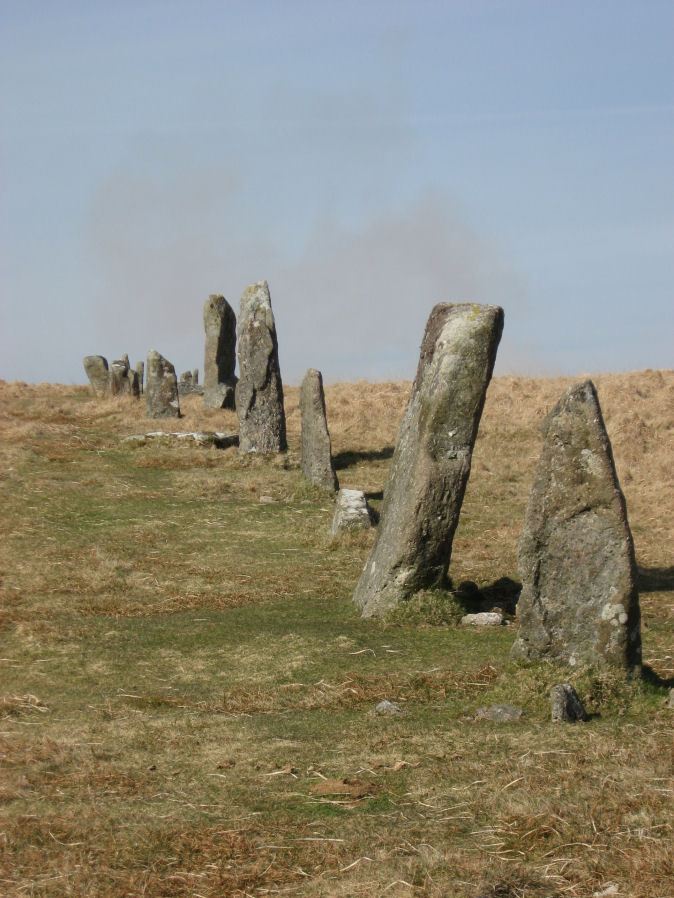
Table of Ritual and Burial Monuments on Staldon Moor
The following table lists the records currently in this Guide Map. For an explantion of the Guide Maps and a table of all 62 Guide Maps, follow this link: Guide List Table. Introductory text will be added to each guide list in 2025. Notes on duplication and omissions will appear below the table once checks have been finalised.
Notes on possible duplications and omissions
Stalldown Row Terminal Cairn Circle[\b] In Butler Volume 5 p.20 fig.2 there is a diagram of Stalldown stone row which includes the unrestored section of the row and ends at "terminal caairn?". There is no explanation of this in the text. The possible cairn circle was brought to my attention by Sam Goodwin. Is it defintitely a cairn circle? I'm not ceratian but I believe it is a plausible and as such shoudl be listed on the HER.[b]Stalldown South East Stone Row: a probable stone row which is perhaps a canddiate for inclusion on the HER. The Stone Rows of Great Britain states: This line of seven stones seems to be artificial and certainly looks like a stone row. The proximity of a number of small cairns further enhances this interpretation as does the visual relationship with Plymouth Sound. The stones however lies between two reaves (prehistoric boundary banks) and close to other boundaries. The possibility of this feature being an unfinished or partly robbed field boundary cannot therefore be wholly discounted. The author visited this site on 16/07/2021 and logged the location of 6 of the 7 stones of this row (must have missed one): SX 63748 61049, SX 63750 61056, SX 63751 61058, SX 63750 61060, SX 63751 61063, SX 63751 61065.
PS. These notes are to assist untangling complicated records and are neither permanent nor a criticism of the HER who do a fantastic job! The author finds it easier to systematically work through these records (2000+ of them) and add these notes, which are then to be communicated with the HER, if appropriate, it is a pragmatic way of dealing with lots of data without continually stopping and starting.
Staldon Moor Guide Map
Guidance for walkers: The monuments featured in this database are archaeological treasures and need to be protected and preserved - please do not disturb any sites. Please check access and firing times before visiting sites, not all sites listed are on open access land. Firing ranges and boundaries of open access areas are marked on the OL28 OS Dartmoor Explorer map. Please stick to the country code and consider giving support to the numerous agencies that help to keep Dartmoor a fabulous natural and historic environment!
List of Ritual and Burial Monuments on Staldon Moor
Burford Down (Tristis Rock) Platform Cairn Circle and Cist
OS Map: SX 63780 60160
HER record: MDV4258
Megalithic Portal: 45689
PMD: Tristis Rock
Alternate name: Tristis Rock Platform Cairn Circle and Cist
ShortName: CT TristisRock
Butler map: 54.17
DPD page: 70
Grinsell: HAR 6
Turner: E22
Barrow Report: 14 40
Notes: "Retaining circle of a barrow, internal diameter between 16 and 17 feet and consisting of twelve stones which enclose the remaining south side stone of a cist. The overall length of the side stone is 4 feet 6 inches, the internal length of the cist would not have been more than 3 feet". Butler Tristis Rock - Vol. 4. Map 54.17 (p.60 diagram of Tristis Rock cairn p.59).
Nearby sites: SX63786016
Burford Down Stone Row
OS Map: SX 63695 60165
HER record: MDV4333
Megalithic Portal: 1463
The Stone Rows of GB: Burford Down
PMD: Burford Down Stone Row
ShortName: SR BurfordDown
Butler map: 54.17
DPD page: 70
Barrow Report: 14 40
Notes: "This single stone row on a slight north slope extends from a crest at 260m OD to a col at 255m OD. It can be traced from its south terminal, marked by a cairn, at SX 63706017 for 336m, bearing 1o, to a possible blocking stone at SX 63706051 and of different character for a further 120m to SX63706062. The recumbent stone, considered ... to be the north terminal lies yet a further 47m distant at SX 63706067." See also: Sea Views at Burford Down
Nearby sites: SX63706017
Burford Down Standing Stone
OS Map: SX 63703 60687
HER record: MDV4333
Megalithic Portal: 1463
PMD: Burford Down Stone Row
ShortName: SS BurfordDown
Butler map: 54.17
DPD page: 70
Notes: "The alleged blocking stone noted by Parsons measures 2.7m by 1.0m and has been split by drilling." TDA Vol. 85 (1953) pp. 145-147 (Hamlyn Parsons).
Nearby sites: SX63706069
Burford Down Encircled Cairn
OS Map: SX 63704 60178
HER record: MDV4257
Megalithic Portal: 719
PMD: Burford Down Stone Row
Alternate name: Burford Down stone row Encircled Cairn
ShortName: EC BurfordDown
Butler map: 54.17
DPD page: 70
Grinsell: HAR 5
Turner: F10
Barrow Report: 14 40
Notes: "The south terminal cairn, 9.0m diameter and 0.6m high, has a central depression, about 2.5m diameter and 0.4m deep, and is edged by 3 upright and 2 fallen orthostats, average 0.7m by 0.2m and up to 0.9m high, the remains of a retaining circle or peristalith."
Nearby sites: SX63706018
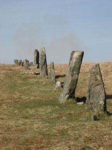
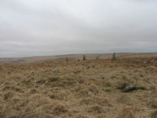
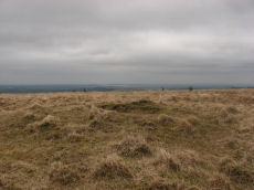
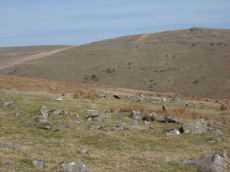
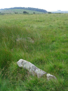
Stalldown Stone Row
OS Map: SX 63223 62558
HER record: MDV4277
Megalithic Portal: 531
The Stone Rows of GB: Stalldown
PMD: Staldon Stone Row
Alternate name: Stalldon Row Stone Row
ShortName: SR Stalldown
Butler map: 54.18
Butler Vol 5: p.20 & Fig.2
DPD page: 67
Notes: "Bronze Age stone row and cairn circle on stall down. The stone row runs north -south for about 850m ow which 500m has been restored. It is associated with three cairns (one either side) and a cairn circle. The stones are mostly 1m to 1.5m high with four over 2m". Lethbridge pp.67-68
Nearby sites: SX63226256
Stalldown Row Terminal Cairn Circle
OS Map: SX 63176 61737
HER: No record found
Megalithic Portal: 531
PMD: Staldon Stone Row
ShortName: CC StallTermin
Butler Vol 5: p.20 & Fig.2
Notes: Unconfirmed terminal cairn. Not listed on HER or NMR
Nearby sites: SX63186174
Stalldown Cairn Circle
OS Map: SX 63244 62423
HER record: MDV4300
Megalithic Portal: 3474
PMD: Staldon Stone Row
Alternate name: Stalldown stone row Cairn Circle
ShortName: CC Staldon 1
Butler map: 54.18.1
DPD page: 68
Grinsell: COR 21
Turner: D26
Notes: Cairn in middle of length of stone row. "The northern part of the row is aligned precisely in the centre of the cairn circle, both of which would therefore seem part of the original design. The cairn is not visible from the south end of the southern extension of the row. This extension consists of four general alignments more of which focus on the cairn circle, and the northern end of the extension is tangential to the west side of the circle. These factors, and the larger size of the stones in the northern extension of the row, suggest two phases of construction." Butler Cairn 1 (Vol 3 54.18). Turner Type Diii 'Ring Setting with Central reduced to subsoil level or paved'.
Nearby sites: SX63246242
Stalldown S. Cairn
OS Map: SX 63219 61864
HER record: MDV4303
ShortName: CN Staldon 2
Butler map: 54.18.2
Grinsell: COR 23
Nearby sites: SX63226186
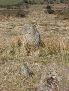
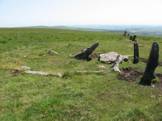
Stalldown Encircled Cairn
OS Map: SX 63208 62489
HER record: MDV4298
Megalithic Portal: 531
Alternate name: Stalldown Summit 3 Encircled Cairn
ShortName: EC Staldon 3
Butler map: 54.18.3
Grinsell: COR 19
Turner: F22
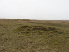
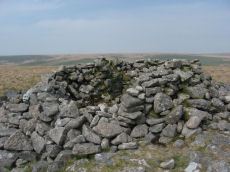
Notes: Cairn with double or multiple ring. Butler Cairn 3 just to the west of the stone row, Butler Cairn 4 is just to the east. A flat topped turf-covered cairn 9.0m in diameter and 0.7m high, in good condition. Settings of Stones in and around the structure suggests a complex cairn circle. The author counted 17 stones in the circle around this cairn. This is difficult to see in the photo as most are concealed under vegetatio, the stone row can be seen in the background. Also visible towards the centre of the circle is a rectangular pit which is probably evidence of excavation. Turner F22, Type Fii
Nearby sites: SX63216249
Stalldown Summit 4 Cairn
OS Map: SX 63281 62458
HER record: MDV4299
ShortName: CN Staldon 4
Butler map: 54.18.4
Grinsell: COR 20
Nearby sites: SX63286246
Stalldown Summit 5 Cairn
OS Map: SX 63500 62300
HER record: MDV13239
ShortName: CN:Staldon 5
Butler map: 54.18.5
Nearby sites: SX63506230
Stalldown Stone Ring Cairn Circle
OS Map: SX 63529 62310
HER record: MDV4301
Megalithic Portal: 45819
Alternate name: Stalldown Summit 6 Stone Ring Cairn Circle
ShortName: RC Staldon 6
Butler map: 54.18.6
Turner: A4
Notes: A circular turf-covered stone ring on the summit of Stalldown Barrow hill. It is 25.5m in diameter, comprising a bank of small stones, 2.0m to 3.0m wide and 0.2m to 0.7m high. There is a 5.0m gap in the south-west but no evidence of disturbance to the interior or of a surrounding ditch. Not far to the east is Hillson's House. Butler Cairn 6 (Vol 3 54.18).
Nearby sites: SX63536231
Hillson's House Cairn
OS Map: SX 63668 62292
HER record: MDV4302
Megalithic Portal: 45592
Alternate name: Hillson's House Cairn
ShortName: CN Hillson Hse
Butler map: 54.18.7
DPD page: 69
Grinsell: COR 22
Notes: Butler Cairn 7 (Vol 3 54.18). On the summit of Stalldown barrow is a large flat-toped cairn around 17.5m across. The cairn has been damaged by the construction of shelters within it - hence it is known as Hillson's House.
Nearby sites: SX63676229
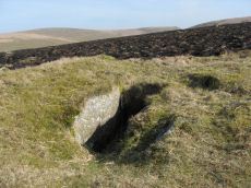
Stalldown N.8 Reported Cist
OS Map: SX 63150 62872
HER record: MDV13235
PMD: Stall Moor NW.
ShortName: CN:Staldon 8
Butler map: 54.18.8
Grinsell: COR 18
Notes: Cairn with possible cist. The top is flat, 6.0m in diameter, and in the centre is an overgrown granite slab, 1.1m by 1.9m, probably the cover-stone of a cist.
Nearby sites: SX63156287
Stalldown (N) Platform Cairn Circle and Cist
OS Map: SX 63274 63239
HER record: MDV4296
Megalithic Portal: 45688
PMD: Stall Moor N.
Alternate name: Stalldown N.9 Platform Cairn Circle and Cist
ShortName: CT Staldon 9
Butler map: 54.18.9
DPD page: 69
Grinsell: COR 13
Turner: E17
Barrow Report: 14 37 62
Notes: "A cist measuring 2 feet 3 inches wide at the south end, 1 foot 7 1/2 inches wide at the north and probably originally 3 feet 6 inches long. Both the coverstone and the north end stone are missing. The cist stands in a barrow which has a retaining circle, five stones of which are still erect, and one fallen. The largest stone is 3 feet 4 inches wide by 2 feet 7 inches high. The diameter of the retaining circle varies from 20 to 22 feet". Lethbridge p.69. diagram p.65 Cist 5. Butler Stalldown N. (Cairn 9) - Vol. 4. Map 54.18.9 (diagram p.62).
Nearby sites: SX63276324
Stalldown N.10 Reported Cairn
OS Map: SX 63470 63560
HER record: MDV129939
ShortName: CN:Staldon10
Butler map: 54.18.10
Notes: Butler: "about thirty metres from the streamworks along a minor tributary of the Erme is a good bowl-shaped cairn with a shallow-pited top". Not listed on NMR or HER.
Nearby sites: SX63476356
Stalldown S.E. (11) Reported Cairn
OS Map: SX 63700 61000
HER record: MDV127842
ShortName: CNxStaldon11
Butler map: 54.4
Notes: No mention of this cairn in NMR but NMR record 442223 is the associated settlement that Butler refers to. HER record MDV127842 metions the hut with central cairn quoting Butler.
Nearby sites: SX63706100
Stalldown Enclosed Settlement
OS Map: SX 63665 61217
HER record: MDV4351
Megalithic Portal: 45322
ShortName: ES Stalldown
Notes: "This settlement consists of 6 enclosures, mostly in poor condition, with 13 associated hut circles and 17 detached ones and extends over 5ha of a gentle to moderate, well drained, southeast facing slope at 270m above OD."
Nearby sites: SX63676122
Staldon Row Ancient Pool
OS Map: SX 63293 62442
HER record: MDV127226
ShortName: PO:Staldon Row
Notes: "A pool measuring around 6.5 metres. One of over 40 such 'sacred' pools identified on Dartmoor that are thought to have potentially been designed during the prehistoric period. Lies to the north of a stone row."
Nearby sites: SX63296244
Stalldown South East Stone Row
OS Map: SX 63746 61059
HER: No record found
The Stone Rows of GB: Stalldown South East
PMD: Stalldown SE1
Alternate name: Stalldown SE1 Stone Row
ShortName: SR StalldownSE
Butler map: 54.4
Notes: The Stone Rows of Great Britain states: "This line of seven stones seems to be artificial and certainly looks like a stone row. The proximity of a number of small cairns further enhances this interpretation as does the visual relationship with Plymouth Sound. The stones however lies between two reaves (prehistoric boundary banks) and close to other boundaries. The possibility of this feature being an unfinished or partly robbed field boundary cannot therefore be wholly discounted." The author visited this site on 16/07/2021 and logged the location of 6 of the 7 stones of this row (must have missed one): SX 63748 61049, SX 63750 61056, SX 63751 61058, SX 63750 61060, SX 63751 61063, SX 63751 61065.
Nearby sites: SX63756106
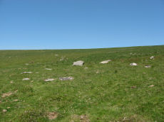
Stall Moor Reported Stone Circle
OS Map: SX 63231 62759
HER record: MDV12421
ShortName: SC:Stall Moor
Notes: HER: An irregular circuit of small, earthfast stones 200 metres to the north of the Stall Down stone row, may represent the remains of an alleged stone circle, which was recorded 64 metres to the northwest of this location, though it is not circular. The internal distance across the stones is 11.5 metres maximum with a minimum of 9 metres. None of the stones exceed 0.4 metres in height
Nearby sites: SX63236276
Lower Piles Enclosed Settlement
OS Map: SX 64396 60528
HER record: MDV4354
Megalithic Portal: 45580
ShortName: ES:Lower Piles
Notes: "Within the newtake known as lower piles. A group of seven huts near the south east corner of the enclosed land. All now composed of fairly small stones the walls appearing as thick banks of stone and turf, not high, but spreading to a width of 1.8m or more. The diameters vary from c 9.20 to c 12.20m outside measurements. Only one hut has a well defined entrance, this is on the south east side of the circle."
Nearby sites: SX64406053
Dry Lake North Enclosed Settlement
OS Map: SX 63922 63602
HER record: MDV4294
Megalithic Portal: 14934
ShortName: ES:DryLakeN
Nearby sites: SX63926360
Blatchford Brook Foot Enclosed Settlement
OS Map: SX 63551 63821
HER record: MDV27894
Megalithic Portal: 14935
ShortName: ES:Blatchford
Nearby sites: SX63556382
Three Barrows W. Enclosed Settlement
OS Map: SX 64414 62651
HER record: MDV4252
Megalithic Portal: 36352
ShortName: ES:3BarrowsW
Butler map: 54.20
Nearby sites: SX64416265
Yadsworthy Waste Clearance Cairn
OS Map: SX 63700 61000
HER record: MDV123437
ShortName: CN:Yadsworthy
Notes: HER: At least eight post medieval clearance cairns, to the south of a prehistoric enclosure, north of Yadsworthy Waste. The mounds are stony and turf covered, approximately circular. The largest has a diameter of 3.2 metres, but most are lower than 0.3 metres high.
Nearby sites: SX63706100
Stall Down Cairn
OS Map: SX 63100 62800
HER record: MDV123436
ShortName: CN:Stall Down
Notes: HER: A turf covered stony mound, is a probable prehistoric cairn, 315 metres north of the Stall Down stone row on Stall Moor. The barrow has a spread diameter of 8.5 metres and stands to 0.5 metres high. The centre of the mound shows signs of minor disturbance.
Nearby sites: SX63106280
Stalldown Reported Cairn
OS Map: SX 63020 62750
HER record: MDV132267
ShortName: CN:Stalldown
Notes: HER: Spooner alleges a cairn here, but this feature could not be found by Grinsell in 1976 or the Ordnance Survey in 1980.. Source is Grinsell - these records are already incorporated so probable duplicate.
Nearby sites: SX63026275
Page last updated 10/12/24