
Guide to the Monuments on Grimspound
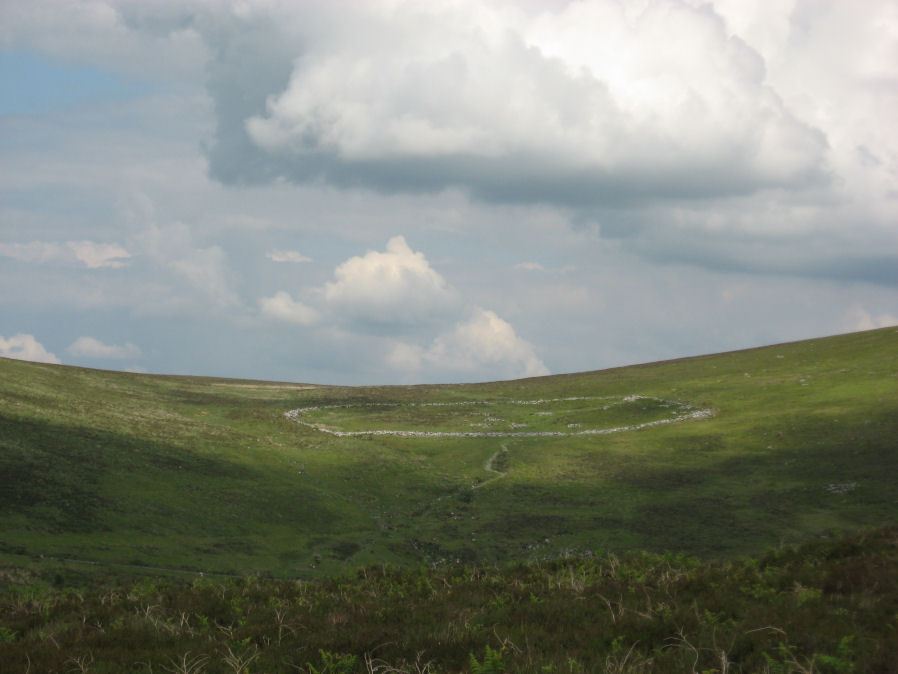
Table of Ritual and Burial Monuments on Grimspound
The following table lists the records currently in this Guide Map. For an explantion of the Guide Maps and a table of all 62 Guide Maps, follow this link: Guide List Table. Introductory text will be added to each guide list in 2025. Notes on duplication and omissions will appear below the table once checks have been finalised.
Notes on possible duplications and omissions
Grimslake Mire (Duplicate) Reported Cist Formerly listed here as Shapley Common 4 but renamed as clearly a duplicate of Grimslake Cist (MDV8744). The description of the cist and cairn are almost identical in the HER record MDV8755. The only significant difference is the grid reference which is approx 250m to the North on Shapley Common. The grid reference is wrong, it is a duplicate.PS. These notes are to assist untangling complicated records and are neither permanent nor a criticism of the HER who do a fantastic job! The author finds it easier to systematically work through these records (2000+ of them) and add these notes, which are then to be communicated with the HER, if appropriate, it is a pragmatic way of dealing with lots of data without continually stopping and starting.
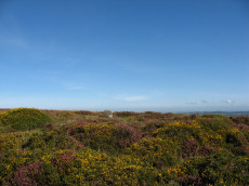
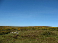
Grimspound Guide Map
Guidance for walkers: The monuments featured in this database are archaeological treasures and need to be protected and preserved - please do not disturb any sites. Please check access and firing times before visiting sites, not all sites listed are on open access land. Firing ranges and boundaries of open access areas are marked on the OL28 OS Dartmoor Explorer map. Please stick to the country code and consider giving support to the numerous agencies that help to keep Dartmoor a fabulous natural and historic environment!
List of Ritual and Burial Monuments on Grimspound

Grimspound Enclosed Settlement
OS Map: SX 70073 80909
HER record: MDV8778
Megalithic Portal: 1344141065
ShortName: ES Grimspound
DPD page: 127
Notes: Probabaly the best known enclosed settlement on Dartmoor, within walking distance of Warren House Inn. "Prehistoric enclosed settlement with a substantial granite surrounding wall, containing 24 hut circles, as well as several 'pens' built into the enclosure wall, positioned in a valley between Hookney Tor and Hameldon. First planned by A. C. Shillibeer in 1829, this site was excavated by the Dartmoor Exploration Committee in 1894-5. Within the guardianship area managed by Dartmoor National Park Authority". Extensive notes on the HER record, see also coverage on Wikipedia and Legendary Dartmoor.
Nearby sites: SX70078091
Hameldown 1 Reported Cairn
OS Map: SX 70390 80690
HER record: MDV26692
ShortName: CN?Hameldown1
Nearby sites: SX70398069
Hameldown N.E. Stone Row
OS Map: SX 71481 80095
HER record: MDV18865
Megalithic Portal: 6333472
The Stone Rows of GB: Hameldown
PMD: Berry Pound Stone Row
Alternate name: Hamel Down Stone Row
ShortName: SR Hamel NE
Butler map: 20.3
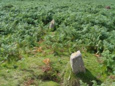
Notes: No NMR listing. HER record MDV18865. Described in Butler Volume 1 Map 20.3. To the south of Berry Pound is a small longhouse. "Within the abandoned field 250m south of the longhouse are the probable remains of a single row first recorded in 1983. Five or six stones remain in line up to 206m apart, the rest having been removed or buried when the field was ploughed."
Nearby sites: SX71488010

Kings Barrow Cairn
OS Map: SX 70927 81449
HER record: MDV8743
ShortName: CN KingsBarrow
Butler map: 20.6
Grinsell: N.BOV 4
Notes: Large circular cairn. Largely grassed over but head-sized granite boulders visible. No remains of kerb visible, but there is a slight trace of an encircling ditch. The centre of the barrow has been robbed.
Nearby sites: SX70938145
Hookney Tor Cairn
OS Map: SX 69905 81314
HER record: MDV6611
Megalithic Portal: 34982
Alternate name: Hookney Tor summit Cairn
ShortName: CN HookneyTor
Butler map: 20.7
Grinsell: N.BOV 2
Notes: Tor cairn north of Hookney Tor and resembling a barrow in shape. Enough of the topsoil has been removed to show that the mound is a natural outcrop feature covered with turf and heather, enclosed on three sides by a broken turf and stone bank. A footpath approaching the west side has probably effaced the remainder of the circuit.
Nearby sites: SX69918131

Hookney Tor North A Ancient Pool
OS Map: SX 69843 81721
HER record: MDV127212
ShortName: PO HookneyTorA
Notes: "A pool measuring 15 by 9.5m. One of over 40 such 'sacred' pools identified on Dartmoor that are thought to have potentially been designed during the prehistoric period. Lies near a prehistoric cairn."
Nearby sites: SX69848172
Hookney Tor North B Ancient Pool
OS Map: SX 69838 81605
HER record: MDV127213
ShortName: PO HookneyTorB
Notes: "A pool measuring 7.5m. One of over 40 such 'sacred' pools identified on Dartmoor that are thought to have potentially been designed during the prehistoric period."
Nearby sites: SX69848161

Shapley Common 3 Cairn
OS Map: SX 69842 81776
HER record: MDV6648
ShortName: CN?Shapley 3
Nearby sites: SX69848178
Berry Pound
OS Map: SX 71325 80349
HER record: MDV8754
ShortName: PD:Berry
Notes: Berry Pound a Prehistoric enclosure on Hamel Down
Nearby sites: SX71338035
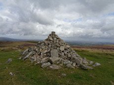
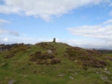
Hameldown Tor Cairn
OS Map: SX 70318 80574
HER record: MDV8768
Megalithic Portal: 16628
ShortName: CN HameldonTor
Butler map: 20.8
Butler Vol 5: p.166 & Fig.106
Grinsell: MAN 2
Turner: E54
Notes: Cairn on hameldown tor.(diam 14m. Heig 700mm)a denuded cairn with kerb of large stones on northern half only. Pillar and conical mound of small stones of evidently modern date. Remainder of kerb visible (11 stones). Remainder of cairn largely grassed over but head sized granite boulders visible (os trig. Point and recent mound of stones on top). Butler Volume 1 Map 20.8.
Nearby sites: SX70328057

Broad Barrow Stone Ring Cairn Circle
OS Map: SX 70577 79908
HER record: MDV20787
Megalithic Portal: 16630
Alternate name: Broad Burrow Stone Ring Cairn Circle
ShortName: RC BroadBarrow
Butler map: 20.9
Butler Vol 5: p.166 & Fig.106
Grinsell: MAN 10
Turner: A46
Notes: "Infilled ring cairn. Stone ring 14 metres diameter internally with bank 2.5 metres wide and 0.4 metres high. Infilled to 0.25 metres below bank top." Butler Volume 1 Map 20.9.
Nearby sites: SX70587991

Single Barrow Cairn
OS Map: SX 70576 79538
HER record: MDV7487
Megalithic Portal: 16631
ShortName: CN SingleBarro
Butler map: 20.10
Butler Vol 5: p.23 & Fig.106
Grinsell: MAN 11
Notes: Round barrow, crowned by boundary stone dated 1854, and inscribed single burrow. Excavated 1873. Diameter 23 metres, height 1.0 metres. Butler Volume 1 Map 20.10.
Nearby sites: SX70587954

Two Barrows Stone Ring Cairn Circle
OS Map: SX 70654 79219
HER record: MDV7409
Megalithic Portal: 16632
Alternate name: Two Barrows 1 Stone Ring Cairn Circle
ShortName: RC TwoBarrows1
Butler map: 20.11.1
Butler Vol 5: p.23 & Fig.106
Grinsell: MAN 12
Barrow Report: 21 56
Notes: "The northern barrow was excavated in 1872. It measures 40 feet in diameter and 4 1/2 feet high. A ring of stones encircled the barrow and in the centre was a small cairn. A cremation burial was found to the SE of the centre covered by five flat stones. With the cremation was the blade of a bronze dagger and a pommel made from amber with a decoration consisting of rows of gold pins" See: Bate, C Spence, Researches into Some Antient Tumuli on Dartmoor, T.D.A. Vol. 5 pp.549-58 (1872). Relevant Butler map Vol. 1. Map 20. Butler Volume 1 Map 20.11 Two Barrows 1. [N.b. Treated as Turner type Stone Ring Cairn circle from the description].
Nearby sites: SX70657922
Two Barrows S Cairn
OS Map: SX 70663 79203
HER record: MDV7411
Megalithic Portal: 16632
Alternate name: Two Barrows 2 Cairn
ShortName: CN TwoBarrows2
Butler map: 20.11.2
Butler Vol 5: p.23 & Fig.106
Grinsell: WID 3
Notes: Two Barrows 2. An oval, stony mound measuring 15.5m E-W and 10.5m N-S. It stands up to 1.1m high and was probably originally bowl-profiled. The N slope is spit by a narrow path and a N-S slope across the top of the barrow has caused minor damage. It appears to be unexcavated. The mounds is crossed by a maintained drystone field wall, approaching from the SE and turning W on the barrow. The wall is built over the mound and does not seem to have caused much damage. This barrow appears to have been a target point for a reave, Fleming's Hameldon South, approaching from the E and stopping 3.5m short of the mound. The reave line is continued W by the modern wall beyond the barrow. See also: Bate, C Spence, Researches into Some Antient Tumuli on Dartmoor, T.D.A. Vol. 5 pp.549-58 (1872). Butler Volume 1 Map 20.11
Nearby sites: SX70667920
Blackaton Down N. Cairn
OS Map: SX 70683 79094
HER record: MDV7413
Megalithic Portal: 16633
ShortName: CN Blackaton N
Butler map: 20.12.1
Butler Vol 5: p.193 & Fig.137
Grinsell: WID 4
Notes: The earthwork remains of two Bronze Age cairns. 'B' is a cairn 42 feet in diameter and 3 feet high. Cairn with small hollow towards centre. Butler Volume 1 Map 20.12.
Nearby sites: SX70687909
Blackaton Down S. Cairn
OS Map: SX 70732 79047
HER record: MDV7412
Megalithic Portal: 16634
ShortName: CN:Blackaton S
Butler map: 20.12.2
Butler Vol 5: p.192 & Fig.136
Grinsell: WID 5
Notes: ['A' SX 7073 7904]. Tumuli on saddle, 'A' is 40 feet in diameter with a rim 1 ft. high. One of pair of cairns, this one is concave or "saucer" shaped. Butler Volume 1 Map 20.12.
Nearby sites: SX70737905
Hameldown Beacon Cairn
OS Map: SX 70830 78922
HER record: MDV7435
Megalithic Portal: 16635
Alternate name: Hamel Down Beacon Cairn
ShortName: CN HamelBeacon
Butler map: 20.13
Butler Vol 5: p.166 & Fig.106
Grinsell: WID 6
Notes: A grass covered cairn which was alleged to have been used as a beacon in medieval period. Butler Volume 1 Map 20.13
Nearby sites: SX70837892
Blackaton Newtake (Hameldown) Ancient Pool
OS Map: SX 70785 78973
HER record: MDV7527
ShortName: PO:Hameldown
Notes: Previously recorded as a possible cairn (was listed here as Hameldown 2 Reported Cairn), although identification noted later as 'doubtful' - water filled depression with a few surface stones. Identified as one of the 40+ 'sacred pool' sites on the moor, possibly dating from the Prehistoric period.
Nearby sites: SX70797897
Hamel Down S.E.1 Cairn
OS Map: SX 71455 78665
HER record: MDV7520
ShortName: CN Hamel SE1
Butler map: 20.14.1
Grinsell: WID 8
Notes: NMR A. "Heather and gorse covered cairn. Mutilation in top and south face shows a construction of stones. No trace of ditch. On top of the mound is a modern boundary stone inscribed 'DS 1854 Old House'".
Nearby sites: SX71467867
Hamel Down S.E.2 Cairn
OS Map: SX 71474 78507
HER record: MDV7522
ShortName: CN Hamel SE2
Butler map: 20.14.2
Grinsell: WID 9
Notes: NMR B "Cairn on Hamel Down with diameter 10 metres by 0.3 metres high in poor condition with a trench driven across the centre." Some stones exposed or heaped on one side of the cairn.
Nearby sites: SX71477851
Hamel Down W. Cairn
OS Map: SX 69970 79040
HER record: MDV5991
ShortName: CN:Hamel W
Butler map: 20.
Nearby sites: SX69977904
Hameldon Cist
OS Map: SX 71008 78345
HER record: MDV7519
Megalithic Portal: 16636
PMD: Hamel Down S.
Alternate name: Hamel Down S. Cist
ShortName: CT Hameldon
Butler map: 20.15
Butler Vol 5: p.178 & Fig.120
DPD page: 129
Grinsell: WID 7
Barrow Report: 54
Notes: Precise location originally unsurveyed but given approximately by Worth as SX 71257908. This may explain the large discrepancy between the NMR position and that given by Butler and in the HER. Three sides of the cist are visible with the fourth having sunken below the earth. The capstone is incomplete and only partly covers the cavity. Lethbridge diagram p129 and photo top p.129. Butler Hamel Down 15 (S) - Vol. 1. Map 20.15 (Cairn 15 p.149, diagram Vol 5. p.178).
Nearby sites: SX71017835
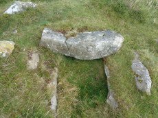
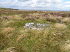
Grimslake Cist Reported Stone Row
OS Map: SX 70412 81154
HER record: MDV8744
The Stone Rows of GB: Grimslake Cist
PMD: Grimslake Cist Stone Row
ShortName: SR Grimslake
Butler map: 20.16
Notes: The author visited this site on 21/06/24 and concluded there was no stone row but took a photo of some stones near the cairn and cist that are roughly linear but not convincing for a stone row. The Stone Rows of Great Britain website reached the same conclusion but with far more detail. This is not in my view a stone row.
This site is now listed as "reported stone row" instead of a "stone row".
Nearby sites: SX70418115
Grimslake Platform Cairn Circle and Cist
OS Map: SX 70414 81166
HER record: MDV8744
Megalithic Portal: 44533
The Stone Rows of GB: Grimslake Cist
PMD: Hookney Down
Alternate name: Grimslake Mire Platform Cairn Circle and Cist
ShortName: CT Grimslake
Butler map: 20.16
Butler Vol 5: p.219 & Fig.153
DPD page: 128
Grinsell: N.BOV 3
Turner: E18
Notes: Cairn with kerb circle and central cist. Lethbridge diagram p.127 and photo top p.128. Butler Grimslake Mire - Vol. 1. Map 20.16 (diagram p.147).
Nearby sites: SX70418117
Grimslake Mire (Duplicate) Reported Cist
OS Map: SX 70410 81440
HER record: MDV8755
ShortName: CT:GrimslakDup
Notes: The cist is set in a definite cairn with a retaining kerb within the cairn. May have been confused with cairn to the south; MDV8744.
Formerly listed here as Shapley Common 4 but renamed as clearly a duplicate of Grimslake Cist (MDV8744). The description of the cist and cairn are almost identical in the HER record MDV8755. The only significant difference is the grid reference which is approx. 250m to the North on Shapley Common. The grid reference is wrong, it is a duplicate.
Nearby sites: SX70418144
Blackaton Ball E. Reported Cairn
OS Map: SX 69467 78786
HER record: MDV5988
ShortName: CNxBlackaton E
Butler map: 20.18.1
Notes: Hut circle
Nearby sites: SX69477879
Blackaton Ball W. Reported Cairn
OS Map: SX 69435 78788
HER record: MDV5988
ShortName: CNxBlackaton W
Butler map: 20.18.2
Notes: Hut circle
Nearby sites: SX69447879
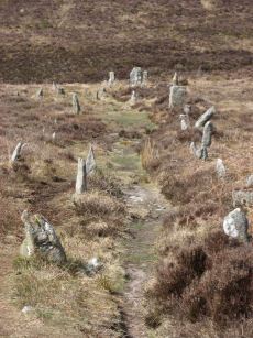
Challacombe Down Stone Row
OS Map: SX 69016 80718
HER record: MDV6600
Megalithic Portal: 1819
The Stone Rows of GB: Challacombe Down
PMD: Challacombe Stone Row
ShortName: SR Challacombe
Butler map: 24.3
Butler Vol 5: p.239 & Fig.169
DPD page: 126
Notes: "Bronze Age triple stone row well marked and wider apart at the north, drawing nearer to the south where they meet a blocking stone of unusual size. The stones have suffered little in their restoration except that a stone in the middle row was turned to form a blocking stone for that row. The loose stones scattered to the west of the north end have been suggested to form a stone circle and additional rows but may be stones excavated from the north end of the stone row." Breton p.41-42
Nearby sites: SX69028072

Challacombe Down Cairn Circle
OS Map: SX 68980 80840
HER record: MDV49462
Megalithic Portal: 1819
PMD: Challacombe Down Stone Row
ShortName: CC Challacombe
Butler map: 24.3
Butler Vol 5: p.239 & Fig.169
Turner: G20
Notes: Dubious site - the current arrangement relates to stones placed during restoration of the stone row. See Worth (1953) p. 226 on how "nothing coherent" came of attempts to re-erect stones scattered to the west of the north end of the row which gave the appearance of a stone circle.
Nearby sites: SX68988084
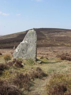
Challacombe Down Standing Stone
OS Map: SX 69021 80723
HER record: MDV6600
Megalithic Portal: 10092
PMD: Challacombe Stone Row
ShortName: SS Challacombe
Butler map: 24.3
DPD page: 126
Notes: The largest and most prominent blocking stone of the Dartmoor rows is to be found at the Challacombe triple row. Worth states that it is over 5 feet in width at the base and over 6 feet in height. Butler (Vol. 2) states that the terminal pillar is today 0.5m shorter than when it was measured in 1893.
Nearby sites: SX69028072

Headland Warren 1 Cairn
OS Map: SX 69442 81584
HER record: MDV103580
ShortName: CN Headland 1
Nearby sites: SX69448158

Headland Warren 2 Cairn
OS Map: SX 69361 81746
HER record: MDV103581
ShortName: CN Headland 2
Nearby sites: SX69368175
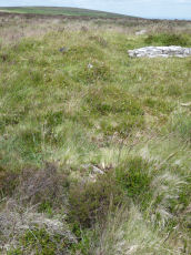
Langworthy Reported Cairn
OS Map: SX 70668 77189
HER record: MDV26861
ShortName: CN Langworth
Butler map: 19.3
Notes: Listed by Butler but no cairn listed in HER or NMR. Maybe hut circle HER 26861. Visited by the author 15/09/19 as can be seen in the photo there is clearly a cairn here although it is in a very dilapidated state.
Nearby sites: SX70677719
Page last updated 10/12/24