
Guide to the Monuments on Drizzlecombe

Table of Ritual and Burial Monuments on Drizzlecombe
The following table lists the records currently in this Guide Map. For an explantion of the Guide Maps and a table of all 62 Guide Maps, follow this link: Guide List Table. Introductory text will be added to each guide list in 2025. Notes on duplication and omissions will appear below the table once checks have been finalised.
Notes on possible duplications and omissions
NB Gutter Tor cairns: This are spread over 3 of the guides: 42, 47, 48
PS. These notes are to assist untangling complicated records and are neither permanent nor a criticism of the HER who do a fantastic job! The author finds it easier to systematically work through these records (2000+ of them) and add these notes, which are then to be communicated with the HER, if appropriate, it is a pragmatic way of dealing with lots of data without continually stopping and starting.
Drizzlecombe Guide Map
Guidance for walkers: The monuments featured in this database are archaeological treasures and need to be protected and preserved - please do not disturb any sites. Please check access and firing times before visiting sites, not all sites listed are on open access land. Firing ranges and boundaries of open access areas are marked on the OL28 OS Dartmoor Explorer map. Please stick to the country code and consider giving support to the numerous agencies that help to keep Dartmoor a fabulous natural and historic environment!
List of Ritual and Burial Monuments on Drizzlecombe
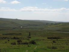
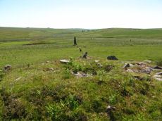
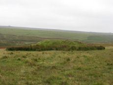
Drizzlecombe Ceremonial Complex
OS Map: SX 59200 67000
HER record: MDV3376
Megalithic Portal: 1906
PMD: Drizzlecombe C
ShortName: CX Drizzle
Butler map: 49.19
DPD page: 38
Notes: Lethbridge pp.38-42. Diagram p.38. Ceremonial complex consisting of three stone rows headed by massive standing stones and also associated cairns and cists.
Nearby sites: SX59206700
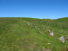
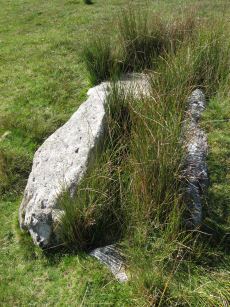
Drizzlecombe S. Stone Row
OS Map: SX 59161 66949
HER record: MDV14777
Megalithic Portal: 1905
The Stone Rows of GB: Drizzlecombe 1
PMD: Drizzlecombe A Stone Row
Alternate name: Drizzlecombe 1 Stone Row
ShortName: SR Drizzle S
Butler map: 49.19.1
DPD page: 40
Notes: Butler Row 1, NMR Row 3, Worth Row A. See notes for Drizzlecombe B (N.W.) row. Lethbridge Row A pp.38-42. Diagram p.38. See also: Sea Views at Drizzlecombe 1
Nearby sites: SX59166695
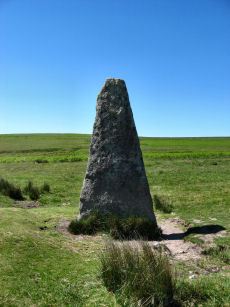
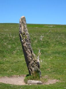
Drizzlecombe S. Standing Stone
OS Map: SX 59057 66868
HER record: MDV14778
Megalithic Portal: 16927
PMD: Drizzlecombe Standing Stones
ShortName: SS Drizzle S
Butler map: 49.19
DPD page: 40
Notes: Terminal stone of the southern double row at Drizzlecombe. The standing stone at the southwest end measures 1.8 metres by 0.4 metres and is 3.2 metres high. Re-erected in 1893. Lethbridge Row A pp.38-42. Diagram p.38. Worth's Row 17/Row A.
Nearby sites: SX59066687
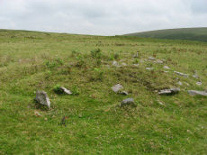
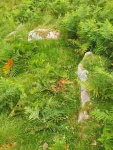
Drizzlecombe S Row Encircled Cairn
OS Map: SX 59170 66964
HER record: MDV14779
Megalithic Portal: 16937
PMD: Drizzlecombe SW Row
Alternate name: Drizzlecombe stone row 1 Encircled Cairn
ShortName: EC Drizzle S
Butler map: 49.19.1
Grinsell: SHE 32
Notes: "Cairn lies at the north-east end of Row A (South Row)of the Drizzlecombe group. Cairn measures 6.7 metres in diameter, up to 0.8 metres high, with central hollow 2.3 metres by 1.5 metres by 0.25 metres deep." "Small number of edge stones around the periphery represent a kerb. Large flat stone, 1.7m by 1m by 0.3m thick, situated immediately s of the mound may be the displaced coverstone from a cist"
Nearby sites: SX59176696
Drizzlecombe N.E. Stone Row
OS Map: SX 59258 67054
HER record: MDV14776
Megalithic Portal: 536
The Stone Rows of GB: Drizzlecombe 2
PMD: Drizzlecombe C Stone Row
Alternate name: Drizzlecombe 2 Stone Row
ShortName: SR Drizzle NE
Butler map: 49.19.2
DPD page: 39
Notes: Butler Row 2, NMR Row 2, Worth Row C. Terminated by the tallest standing stone on Dartmoor. It is 4.2m in height with a distinctive bulging profile at the top the broad face is across the row unlike the other two Drizzlecombe rows. Interestingly this stone is photographed in Worth's Dartmoor prior to being re-erected. Worth suggests it was probably dragged here from Higher Hartor Tor about 1km away. This standing stone has 3 smaller cairns in close proximity. This is the shortest of the three rows at 83.2m but has larger slabs set further apart with the largest near the cairn. Lethbridge Row B. pp.38-42. Diagram p.38. See also: Sea Views at Drizzlecombe 2
Nearby sites: SX59266705
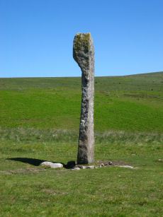
Drizzlecombe N.E. Standing Stone
OS Map: SX 59215 67005
HER record: MDV3377
Megalithic Portal: 16928
PMD: Drizzlecombe Standing Stones
ShortName: SS Drizzle NE
Butler map: 49.19
Butler Vol 5: p.230
DPD page: 39
Notes: Largest standing stone on Dartmoor - terminal for Drizzlecombe stone row. It is 4.2m in height with a distinctive bulging profile at the top. Worth suggests it was probably dragged here from Higher Hartor Tor about 1km away. Re-erected in 1893. Lethbridge Row B. pp.38-42. Diagram p.38. Worth's Row 19/Row C. Used to be listed as HER 14781 perhaps now deleted as an HER duplicate record.
Nearby sites: SX59226701
Drizzlecombe E. Encircled Cairn
OS Map: SX 59267 67065
HER record: MDV4047
Megalithic Portal: 3207
PMD: Drizzlecombe C
Alternate name: Drizzlecombe stone row 2 Encircled Cairn
ShortName: EC Drizzle E
Butler map: 49.19.2
DPD page: 39
Grinsell: SHE 30
Turner: F7
Notes: Eastern most in alignment of 3 cairns. Cairn heads the NE Drizzlecombe row. See diagram in coverage on Prehistoric Dartmoor Walks, marked as C2. Lethbridge Row B. pp.38-42. Diagram p.38. See also 14780
Nearby sites: SX59276707
Drizzlecombe (Central) Encircled Cairn
OS Map: SX 59253 67081
HER record: MDV14772
Megalithic Portal: 3206
PMD: Drizzlecombe B
Alternate name: Drizzlecombe stone row 3 Encircled Cairn
ShortName: EC Drizzle Ce
Butler map: 49.19.3
Grinsell: SHE 29
Turner: F13
Barrow Report: 56
Notes: Central in alignment of 3 cairns. Cairn heads the NW Drizzlecombe row. See diagram in coverage on Prehistoric Dartmoor Walks, marked as C3.
Nearby sites: SX59256708
Drizzlecombe N.W. Standing Stone
OS Map: SX 59134 66988
HER: No record found
Megalithic Portal: 16929
PMD: Drizzlecombe Standing Stones
ShortName: SS Drizzle NW
Butler map: 49.19
DPD page: 40
Notes: Terminal for Drizzlecombe NW stone row. Re-erected in 1893. Lethbridge Row C. pp.38-42. Diagram p.38. NB. This website had previously matched this site with the HER record 3377. That record now clearly refers to the NE stone - although that may not have previously been the case. There is no HER record for this site now. Worth's Row 18/Row B. Previously listed here with a grid referecne of SX 59200 67020 which is quite a bit out.
Nearby sites: SX59136699
Drizzlecombe 4 Stone Row
OS Map: SX 59257 67256
HER: No record found
Megalithic Portal: 1902
The Stone Rows of GB: Drizzlecombe 4
ShortName: SR Drizzle 4
Notes: See also Megalithic Portal: Standing Stone for a nearby small standing stone.
Nearby sites: SX59266726
Drizzlecombe Row 4 Kerbed Reported Cairn
OS Map: SX 59278 67279
HER: No record found
Megalithic Portal: 1902
The Stone Rows of GB: Drizzlecombe 4
ShortName: CN Driz Kerbed
Notes: This site is a possible kerbed cairn very close to Drizzlecombe Stone Row 4. This site was looked at by Sandy Gerrard, ACE Archaeology and the current author on 07/09/2019 whilst surveying the possible stone row 4.
Nearby sites: SX59286728
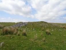
Drizzlecombe Enclosed Settlement
OS Map: SX 59341 67152
HER record: MDV4046
Megalithic Portal: 10509
ShortName: ES Drizzle
Butler map: 49.19
DPD page: 39
Notes: "The drizzlecombe pound (diam (max 67m, min 64m), thic of wall (max 1.52m, min 1.37m), area 0.3ha) is not circular as there is a considerable length of straight wall on the sw. The wall is much ruined in parts. An inner lining of slabs is still visible on the nw side. Mean elevation of ground is 366m od ground slopes to sw with mean gradient of 1 in 7. A cairn lies a few yards outside the pound wall, two hut circles within the enclosure. The entrance is in the west wall". Lethbridge pp.38-42, diagram p.38.
Nearby sites: SX59346715
Drizzlecombe S Row Reported Cist
OS Map: SX 59169 66957
HER record: MDV14779
PMD: Drizzlecombe SW Row
ShortName: CT-DrizzleSRow
Butler map: 49.19.1
Nearby sites: SX59176696
Drizzlecombe N.W. Stone Row
OS Map: SX 59243 67071
HER record: MDV3376
Megalithic Portal: 1904
The Stone Rows of GB: Drizzlecombe 3
PMD: Drizzlecombe B Stone Row
Alternate name: Drizzlecombe 3 Stone Row
ShortName: SR Drizzle NW
Butler map: 49.19.3
DPD page: 40
Notes: Butler Row 3, NMR Row 1, Worth Row B. The NW and S terminal stones have their broad face parallel to the row. The NW row is single for half of its 149.5m length uphill then double for 47m before becoming single again for the last 28m to the cairn. This arrangement appears to be the original design. The other two stone rows are single throughout. The S row is exactly the same length as the NW row but with smaller stones. The average interval between the stones is almost identical and the orientation of the row is such that it gently curves southwards downhill bringing the lower part of the row parallel to the S row. This shift of 7 degrees in alignment of the NW row from top to bottom to line up with the S row would suggest it was constructed later to match the S row. The height of the terminating stones for S and NW rows are 3m and 2.3m respectively.
Nearby sites: SX59246707
Drizzlecombe (W) Encircled Cairn
OS Map: SX 59236 67101
HER record: MDV3329
Megalithic Portal: 10499
PMD: Drizzlecombe N Row
Alternate name: Drizzlecombe 4 Encircled Cairn
ShortName: EC Drizzle W
Butler map: 49.19.4
Grinsell: SHE 28
Turner: F24
Notes: Western most in alignment of 3 cairns. The other two cairns head Drizzlecombe rows. See diagram in coverage on Prehistoric Dartmoor Walks, marked as C4. Turner F24
Nearby sites: SX59246710
Giant's Basin Cairn
OS Map: SX 59202 66945
HER record: MDV3372
Megalithic Portal: 538
Alternate name: Giant's Basin Cairn
ShortName: CN GiantsBasin
Butler map: 49.19.5
DPD page: 40
Grinsell: SHE 33
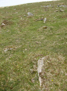
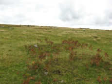
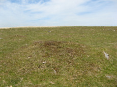
Notes: The Giant's Basin is an impressive but heavily disturbed cairn lying adjacent to the Drizzlecombe Stone Rows. It measures approximately 22 metres in diameter, a maximum of 3 metres high and is partially turf-covered. An approximately 2.5 metre wide reed-covered slight depression around its circumference suggests a silted ditch. Much of the central part of the cairn has been removed to a depth of 1.65m and most of excavated material in the form of fist-sized stones and small boulders has been deposited around the rim of the mound.
Nearby sites: SX59206695
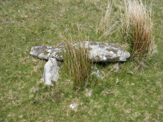
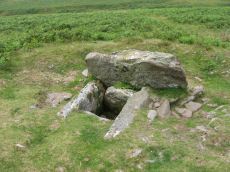
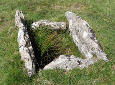
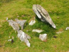
Giants Basin (near) Cist
OS Map: SX 59181 66953
HER record: MDV3373
Megalithic Portal: 18464
PMD: Giants Basin Foot
Alternate name: Drizzlecombe 6 Cist
ShortName: CT GiantsBasin
Butler map: 49.19.6
Grinsell: SHE 33d
Barrow Report: 12
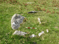
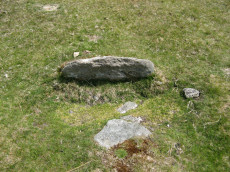
Notes: "The structure comprises a flat slab measuring 1.2m by 0.76m which rests at a slight angle on three upright slabs. These slabs, up to 0.4m high, form a 'z' shape on plan in what appears to be a slight hollow. This feature has been classified by some authorities as a cist although others reject this interpretation for either positional or structural reasons. The historical and archaeological tradition for the existence of a cist here is by no means certain. Known cists in the locality have invariably had their coverstones removed and are open. It is a scheduled ancient monument." The arrangement in the photo could well be natural.
Nearby sites: SX59186695
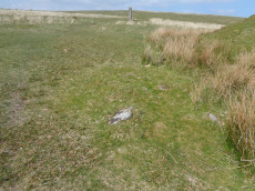
Giants Basin Foot Reported Cist
OS Map: SX 59225 66944
HER record: MDV3380
PMD: Drizzlecombe
ShortName: CT?Giants Ba1
Barrow Report: 12
Notes: To the east of the giants basin are two stones which stand parallel to each other, and resemble the two longer sides of a cist. Probably a duplicate of SHE 33a or SHE 33d.
UPDATE 31/12/2022. The HER gives an NGR of SX 5913 6699. This is to the *west* of the Giants Basin and Worth very clearly states to the east. We will arbitrarily assign an NGR which is slightly to the east. SX 59225 66944 - it is a guess of the reported location.
Nearby sites: SX59236694
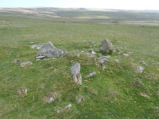
Foot of Giant's Basin (a-c) Cairnfield Master
OS Map: SX 59190 66930
HER: No record found
Alternate name: Foot of Giant's Basin (a-c) Cairnfield Master
ShortName: CN:FootofBasin
Butler map: 49.19.7-9
Notes: Grinsell SHE 33a-c. This is the master record for 3 small cairns at the foot of Giant's Basin and as such set as a duplicate record. Site type is set to "Cairnfield" as best fit i.e. a master record. See individual entries.
Nearby sites: SX59196693
Foot of Giant's Basin (a) Cairn
OS Map: SX 59188 66945
HER record: MDV55251
Alternate name: Foot of Giant's Basin (a) Cairn
ShortName: CN FootGB 1
Butler map: 49.19.7-9a
Grinsell: SHE 33a
Notes: 1 of 3 small cairns at the foot of Giant's Basin.
Nearby sites: SX59196695
Foot of Giant's Basin (b) Cairn
OS Map: SX 59189 66941
HER record: MDV55251
Alternate name: Foot of Giant's Basin (b) Cairn
ShortName: CN FootGB 2
Butler map: 49.19.7-9b
Grinsell: SHE 33b
Notes: 1 of 3 small cairns at the foot of Giant's Basin.
Nearby sites: SX59196694
Foot of Giant's Basin (c) Cairn
OS Map: SX 59190 66935
HER record: MDV55251
Alternate name: Foot of Giant's Basin (c) Cairn
ShortName: CN FootGB 3
Butler map: 49.19.7-9c
Grinsell: SHE 33c
Notes: 1 of 3 small cairns at the foot of Giant's Basin.
Nearby sites: SX59196694
Foot of NE Longstone (1) Reported Cairn
OS Map: SX 59206 67009
HER record: MDV55243
Alternate name: Foot of Longstone 2 (1) Reported Cairn
ShortName: CN Foot of NE1
Butler map: 49.19.10
Notes: The HER has these entries for this group of 3 cairns MDV55243, MDV55249, MDV55250. Those entries have been assigned arbitrarily to our 3 records as it is difficult to match up. The grid references for this record is from a Garmin reading.
Nearby sites: SX59216701
Foot of NE Longstone (2) Reported Cairn
OS Map: SX 59220 66999
HER record: MDV55249
Alternate name: Foot of Longstone 2 (2) Reported Cairn
ShortName: CN Foot of NE2
Butler map: 49.19.11
Notes: The HER has these entries for this group of 3 cairns MDV55243, MDV55249, MDV55250. Those entries have been assigned arbitrarily to our 3 records as it is difficult to match up. The grid references for this record is from a Garmin reading.
Nearby sites: SX59226700
Foot of NE Longstone (3) Reported Cairn
OS Map: SX 59204 67002
HER record: MDV55250
Alternate name: Foot of Longstone 2 (3) Reported Cairn
ShortName: CN:Foot of NE3
Butler map: 49.19.12
Notes: Not listed in NMR But near this row 438619. The third of Butler's cairns at the foot of the NE standing stone. The grid reference is estimated from the plan given by Butler that shows 3 cairns around the menhir fig 49.18 p.135 Vol 3.
The HER has these entries for this group of 3 cairns MDV55243, MDV55249, MDV55250. Those entries have been assigned arbitrarily to our 3 records as it is difficult to match up.
Nearby sites: SX59206700
Drizzlecombe, North Cist
OS Map: SX 59156 67215
HER record: MDV3339
Megalithic Portal: 534
PMD: Drizzlecombe N 13
Alternate name: Drizzlecombe 13 Cist
ShortName: CT Drizzle 13
Butler map: 49.19.13
DPD page: 41
Grinsell: SHE 25
Barrow Report: 19
Notes: Butler Drizzlecombe - Vol. 3. Map 49.19.13 (pp.135-142, general plan of Drizzlecombe complex p.135, diagram p.140 Cairn 13). Lethbridge p.38-41, diagram p.38 Cist B(2)
Nearby sites: SX59166722
Drizzlecombe Platform Cairn Circle
OS Map: SX 59135 67134
HER record: MDV3374
Megalithic Portal: 16932
PMD: Drizzlecombe N 14
Alternate name: Drizzlecombe 14 Platform Cairn Circle
ShortName: PC Drizzle 14
Butler map: 49.19.14
Grinsell: SHE 25a
Turner: E35
Barrow Report: 34 56
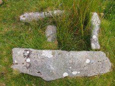
Notes: "stone circle" marked on os 6" 1906. This site was almost totally excavated in 1914. Half an 11 foot diameter kerb circle and the slight remains of a cairn were found.3 flint flakes and a "well finished" scraper were found. The 34th Barrow Report includes a photo of the flints and the excavated and exposed kerb.
Nearby sites: SX59146713
Drizzlecombe 15 Cairn
OS Map: SX 59262 67208
HER record: MDV3368
ShortName: CN Drizzle 15
Butler map: 49.19.15
Grinsell: SHE 26
Notes: Cairn or hut circle? Probable cairn - although only hut circles listed in this precise location on HER although there are also numerous cairns in the general area. The photo of this site matches well the diagram given by Butler on p.141 of Vol 3 of the Dartmoor Atlas of Antiquities with the four large slabs radiating out from the centre.
Nearby sites: SX59266721
Drizzlecombe 16 Reported Cairn
OS Map: SX 59277 67215
HER record: MDV3369
ShortName: CN Drizzle 16
Butler map: 49.19.16
Notes: Possibly HER MDV3369 "A group of three cairns near two huts to the south-west of enclosure at Drizzlecombe. All the cairns have been dig into and some are hard to differentiate from the huts."
Nearby sites: SX59286722
Drizzlecombe 17 Cairn
OS Map: SX 59240 67188
HER record: MDV3369
ShortName: CN Drizzle 17
Butler map: 49.19.17
Notes: "A group of three cairns near two huts to the south-west of enclosure at Drizzlecombe. All the cairns have been dig into and some are hard to differentiate from the huts."
Nearby sites: SX59246719
Drizzlecombe 18 Cairn
OS Map: SX 59376 67182
HER record: MDV4032
ShortName: CN Drizzle 18
Butler map: 49.19.18
Grinsell: SHE 27
Notes: "A large cairn now disturbed and partially covered by low vegetation lies in open moorland. Composed of stones and small boulders it is 17.7 metres in diameter and a maximum 1.9 metres high. Spoil has been dumped around the top of the mound from the central excavation pit; three backfilled trenches extend from this central depression. There is no visible evidence of a kerb or cist."
Nearby sites: SX59386718

Drizzlecombe 19 Reported Cairn
OS Map: SX 59557 67280
HER record: MDV126615
ShortName: CN?Drizzle 19
Butler map: 49.19.19
Notes: Butler: Identity of this "structure is uncertain, a circular stony bank surounding a slightly raised but uneven interior .. it also is likely tobe a badly damaged burial mound"
The author took this photo on 22/09/2024. Is it remains of a round house? There are none listed on the HER directly at this location and there are also no cairns listed here. Butler does list a cairn near to this grid reference so maybe this is the feature that Butler observed.
Nearby sites: SX59566728

Drizzlecombe 20 Cairn
OS Map: SX 59685 67315
HER record: MDV4034
PMD: Drizzlecombe 20
ShortName: CN Drizzle 20
Butler map: 49.19.20
Grinsell: SHE 31
Notes: A cairn situated on a south-facing slope below the crest of a ridge. It consists largely of small stones, partly heather-covered and has a diameter of 9.5 m and a height of 0.5 m; there is a depression of 0.6 m in the centre with a cavity which could be the site of a ruined cist.
Nearby sites: SX59696732
Drizzlecombe Cist
OS Map: SX 59227 67478
HER record: MDV3363
Megalithic Portal: 16934
PMD: Drizzlecombe N.
Alternate name: Drizzlecombe 21 Cist
ShortName: CT Drizzle 21
Butler map: 49.19.21
DPD page: 41
Grinsell: SHE 24
Barrow Report: 26 34
Notes: Butler Vol. 3. Map 49.19.21 (pp.135-142, general plan of Drizzlecombe complex p.135, diagram p.141 Cist 21). Lethbridge p.38-41, diagram p.38 Cist C(3)
Nearby sites: SX59236748
Drizzlecombe, South Cist
OS Map: SX 59033 66725
HER record: MDV3340
Megalithic Portal: 16933
PMD: Drizzlecombe SW.
Alternate name: Drizzlecombe 22 Cist
ShortName: CT Drizzle 22
Butler map: 49.19.22
DPD page: 41
Grinsell: SHE 34
Barrow Report: 19
Notes: Lethbridge p.38-41, diagram p.38 Cist A(1) Butler Drizzlecombe - Vol. 3. Map 49.19.22 (pp.135-142, general plan of Drizzlecombe complex p.135, diagram p.141 Cist 22).
Nearby sites: SX59036673
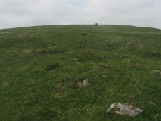
Drizzlecombe 23 Reported Cairn
OS Map: SX 59423 67331
HER record: MDV103613
ShortName: CN Drizzle 23
Notes: This record has previously been listed as a "pos duplicate". However, there is a cairn at this location that matches no other records as can be seen in the photo. The HER NGR was SX 59418 67321. The item in the photo is at SX 59423 67331
Nearby sites: SX59426733
Drizzlecombe 24 Reported Cairn
OS Map: SX 59376 67356
HER: No record found
ShortName: CN Drizzle 24
Notes: There is a cairn at this location that matches no other records as can be seen in the photo. It is at the uphill end of a little known stone row.
Nearby sites: SX59386736
Drizzlecombe 25(pos duplicate) Reported Cairn
OS Map: SX 59200 66990
HER record: MDV55250
ShortName: CN:Drizzle 25
Nearby sites: SX59206699

Drizzlecombe 26 Reported Cairn
OS Map: SX 59694 67323
HER: No record found
ShortName: CN Drizzle 26
Notes: Tha author was looking for SiteID=1522 HER=MDV4034 on 22/09/2024. This feature was around 10 metres away from that cairn and looks like another possible cairn. It is not recorded on the HER.
Nearby sites: SX59696732
Drizzlecombe Settlement Reported Cist
OS Map: SX 59232 67271
HER: No record found
PMD: Drizzlecombe Settlement
ShortName: CT-Drizzle 27
Notes: A claimed possible cist that could just be a natural arrangement. "An arrangement of stones made up of a pair of long edge-set orthostatic slabs placed to the E and S of a large tilted slab. It is possible that this is a disturbed cist, comprising a displaced sidestone and two endstones but the two orthostats are not parallel and there is no clear central depression. the length between the endstones is 1.2m and the height of the tilted slab is 0.49m. NGR SX 5928 6727" (From Robertson,Jennifer 1991 The Archaeology of the Upper Plym Unpublished PhD Thesis p875). No HER record, the NMR (Sept 1999) gives NGR SX 5927 6727. The item in the photo is probably the site referred to and is located at SX 59232 67271
Nearby sites: SX59236727
Giants Hill E Cist
OS Map: SX 59587 66717
HER record: MDV70333
Megalithic Portal: 45812
ShortName: CT GiantsHillE
DPD page: 48
Notes: "A little further to the east on giant's hill another cist was photographed in 2004. A large flat stone c0.9m x c0.9m partly covered by vegetation is the capstone of a small square cist c0.56m x 0.56m. One of the side stones is missing. (lethbridge)." Lethbridge p.48 Giant's Hill unscheduled Cist diagram p.47.
Nearby sites: SX59596672
Giants Hill W Cist
OS Map: SX 59444 66753
HER record: MDV55396
Megalithic Portal: 45813
PMD: Giants Hill
ShortName: CT GiantsHillW
DPD page: 48
Notes: "The cist is situated at the wsw end of the cairn, is 1.4m by 0.7m by 0.3m deep and is orientated ne-sw". Lethbridge p.48 Giant's Hill scheduled Cist diagram p.47.
Nearby sites: SX59446675
Leeden Cist
OS Map: SX 58695 67845
HER record: MDV3341
Megalithic Portal: 45710
PMD: Eylesburrow W.
Alternate name: Eylesbarrow S.W. Cist
ShortName: CT Leeden
Butler map: 47.11
DPD page: 30
Grinsell: SHE 7
Barrow Report: 48
Notes: Butler Eylesbarrow S.W - Vol. 3. Map 47.11 (diagram p.70).
Nearby sites: SX58706785
Yellowmead Down 2 Cairn
OS Map: SX 57782 67747
HER record: MDV4026
ShortName: CN Yellowmead2
Butler map: 47.14.2
Grinsell: SHE 6
Notes: "This cairn has been much robbed by digging away the centre from the north side where there is a 2.0 metre gap in the rim-like perimeter. Its diameter is 8.0 metres and rim height 0.4 metres. There is no trace of a kerb or of a cist."
Nearby sites: SX57786775
Yellowmead Down 4 Cairn Circle
OS Map: SX 58195 67810
HER record: MDV102935
ShortName: CN Yellowmead4
Notes: HER: Prehistoric cairn circa 3 metres diameter by 0.3 metres high with a possible kerb on its north-west and west sides. It has a hollow in the centre, 1.2 metres by 0.8 metres.
Nearby sites: SX58206781
Yellowmead Down 5 Cairn
OS Map: SX 58371 67842
HER record: MDV103585
ShortName: CN:Yellowmead5
Nearby sites: SX58376784
Sheepstor Brook Ford 1 Clearance Cairn
OS Map: SX 58172 67504
HER record: MDV132195
ShortName: CN:Sheepstor1
Butler map: 47.14.4
Notes: NMR B. Group of clearance cairns north-west of Ditsworthy Warren thought to be medieval or later.
Nearby sites: SX58176750
Sheepstor Brook Ford 2 Clearance Cairn
OS Map: SX 58149 67489
HER record: MDV132196
ShortName: CN:Sheepstor2
Butler map: 47.14.5
Notes: NMR A. Group of clearance cairns north-west of Ditsworthy Warren thought to be medieval or later.
Nearby sites: SX58156749
Sheepstor Brook Ford 3 Clearance Cairn
OS Map: SX 58250 67425
HER record: MDV132197
ShortName: CN:Sheepstor3
Butler map: 47.14.6
Notes: HER: One of a group of three or four cairns to the north-west of Whittenknowles Rocks
Nearby sites: SX58256743
Sheepstor Brook Ford 4 Reported Cist
OS Map: SX 58195 67426
HER record: MDV132198
PMD: Sheepstor Brook
ShortName: CT:Sheepstor4
Notes: HER: Three small cairns lie on a gentle south-west facing slope at around 308 metres above ordnance datum. They are turf-covered stoney mounds from 3.2 metres to 4.8 metres in diameter and up to 0.6 metres high. Their function and origin are unclear but they are probably stone clearance heaps possibly of prehistoric though more likely of medieval or later date. At SX58256742 a mound roughly circular 2.7 metres in diameter and 0.4 metres high.. Of the 4 cairn entries this one matches closest the NGR of the PMD cist, fieldwork is needed to confirm.
Nearby sites: SX58206743
Sheepstor Brook Ford 5 Clearance Cairn
OS Map: SX 58200 67340
HER record: MDV22766
ShortName: CN:Sheepstor5
Notes: HER: The cairn at this location is one of four such features in this general area. Scheduled in 1992. Recorded in 1999 as being more disturbed - probably as a result of military activity. The form, location and relationship of all the cairns in this area is suggestive of clearance activity in the medieval or later periods. There is no evidence to suggest that they are clearance products of the prehistoric period, although this feature remains on the list of scheduled sites.
Nearby sites: SX58206734

Gutter Tor N. Platform Cairn Circle and Cist
OS Map: SX 57676 67137
HER record: MDV4015
Megalithic Portal: 17511
PMD: Gutter Tor N.
Alternate name: Gutter Tor 3 Platform Cairn Circle and Cist
ShortName: CT GutterTor 3
Butler map: 49.5.3
DPD page: 33
Grinsell: SHE 9
Turner: E38
Barrow Report: 59
Notes: "A cairn with cist and a double circle of stones situated on the north-facing slope of Gutter Tor at about 305m OD. The end-stones and side-stones of the cist are in situ but the coverstone is missing." Lethbridge p.32-33 Cist A. Duplicated by HER 4045.Note Garmin NGR. (Previously listed as Gutter Tor No.2)Butler Gutter Tor 3 - Vol. 3. Map 49.5 (diagram p.118 "North cairn and cist").
Nearby sites: SX57686714
Gutter Tor 5 Cairn
OS Map: SX 57651 66752
HER record: MDV3990
ShortName: CN:GutterTor 5
Grinsell: SHE 16
Turner: A49
Notes: Round barrow and cist south west of Gutter Tor. Slight traces of round barrow. Cist was once reportedly visible but no longer so.
Nearby sites: SX57656675
Whittenknowles Rocks Cairn
OS Map: SX 58712 67167
HER record: MDV66369
ShortName: CN:Whittenkn1
Butler map: 49.11
Notes: The cairn survives as a 4m diameter mound standing up to 0.6m high. Stones protruding around the western and southern edges of the mound may represent a kerb which survives elsewhere as a buried feature.
Nearby sites: SX58716717
Whittenknowles Rocks Enclosed Settlement
OS Map: SX 58550 67050
HER record: MDV3995
Megalithic Portal: 19400
ShortName: ES Whittenknow
Nearby sites: SX58556705
Giants Hill 1 Cairn
OS Map: SX 59631 66875
HER record: MDV3342
ShortName: CN:GiantsHill1
Butler map: 49.14.1
Grinsell: SHA 15
Nearby sites: SX59636688
Giants Hill 2 Cairn
OS Map: SX 59311 66696
HER record: MDV3350
ShortName: CN:GiantsHill2
Butler map: 49.14.2
Grinsell: SHA 14
Nearby sites: SX59316670
Page last updated 10/12/24