
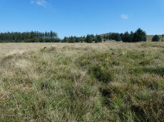
Prehistoric sites within 2km of SX 62780 75100
Guidance for walkers: The monuments featured in this database are archaeological treasures and need to be protected and preserved - please do not disturb any sites. Please check access and firing times before visiting sites, not all sites listed are on open access land. Firing ranges and boundaries of open access areas are marked on the OL28 OS Dartmoor Explorer map. Please stick to the country code and consider giving support to the numerous agencies that help to keep Dartmoor a fabulous natural and historic environment!
About the database listings: In all listings clicking on the photo or the site name will open a page for the site with a larger photo and further details from the database. The database now has over 6680 records covering nearly all publicly listed sites on Dartmoor including around 4800 round houses. This level of detail is of interest to archaeologists but tends to swamp listings of sites more likely to be of interest for walkers. For this reason, the listings default to around 550 core sites only. These are the stone circles, stone rows and the ring cairns listed by Turner. The default search radius is 2 km. The controls below the map can be used to start a new search by entering a 6- or 8-digit reference (without the prefix "SX"). The search radius can be specified and you can add incremental Display layers of detail on top of the core sites. If using a more detailed layer you will need to decrease the search radius to avoid getting hundreds of search results.
- Core sites Default listing of core sites consisting of stone circles & rows and some of the major ring cairns.
- Plus cairns adds approx. 1000 cairns and other minor sites not included in the core listings but excluding round houses.
- Plus round houses adds approx. 4800 round houses.
- Plus non-sites adds in the records for sites that no longer exist or are not prehistoric sites.
- Plus duplicates adds records excluded as duplicates. Those maybe duplicate records in external listings (e.g. the Historic Environment Records). For example, some sites have been identified as cairns in some listings and interpreted as round houses in other listings and both records appear.
These listings have incorporated, matched up and merged all of the records from all of the major archaeological listings including: Worth, Grinsell, Turner, Butler, Bill Radcliffe, Sandy Gerrard, Megalithic Portal, the National Monument Records and the Historic Environment Records. The author would like to thank Bill, Sandy, the lovely people both at Megalithic Portal (especially Anne Tate who did an amazing job to link listings) and at ACE Archaeology for collaborative work over the years to synchronise and correct listings across the various websites which now interlink. A culmination of years of work the final merger of cairn records took 3 months of cross referencing in 2017 the result being a snapshot of the records at that time. This data has in turn been refined since by field work and research. The round house data was supplied by Sandy Gerrard. Grid references are in order of accuracy: from Google Earth satellite, if visible and found, from a Garmin GPS reading, if visited by the author and from the literature otherwise. Individual site pages will state the source of the grid reference and provide satellite imagery. If a site listing lacks a photo it has not yet been visited by the author in which case the grid reference is from the literature.
Currently the database only includes sites which can be represented by a grid reference. Reaves are not included as they require GIS shape technology which is beyond the current capability of this system. To see the sources for the records, look at the tables on the resources menu. The database listings can also be viewed on a Google map and downloaded as GPS datasets for Garmin devices.
Corrections, or any feedback or suggestions are very welcome, email: info@dartmoorwalks.org.uk.
NOTE: Clicking on the icons for each monument in the map will give the name of the site. You can zoom in and out and drag the map around.
List of sites within 2km of SX 62780 75100
Littaford Tor E Cist
OS Map: SX 61846 76717
PMD: Littaford Tor E.
ShortName: CT Littaford 1
Notes: Radcliffe: "Long axis approx W-E . Stones visible on N ,E and S sides and some stone could be felt under grass on W side. Approx. 1m x 0.5m x 0.5m depth internally. No obvious sign of cairn mound. No obvious stonecutting in vicinity. TAP Greeves (pers. comm.) "
Nearby sites: SX 61846 76717
Distance: 1.87km
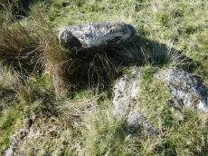
Crockern Tor 3 Reported Cist
OS Map: SX 61204 75824
ShortName: CT CrockernNW3
Notes: Possible cist reported by Nigel Rendle to Bill Radcliffe in 2008 NE of Crockern Farm. Bill comments Feb 2025 we were doubtful of it, as it is close to the path to Wistman's Wood, so how can it have been missed? But it looks good to me.. The author visited 25/09/2025 with Steve Szypko and these were my notes: there is an upright stone that looks like a possible displaced capstone and some other stones that could form a cist. This arrangement in itself is unconvincing but there is also a rectangular hole consistent with a cist. It is perhaps an unlikely but possible cist. NB. The grid reference has now been updated.
Nearby sites: SX 61204 75824
Distance: 1.73km
Bellever Tor (SW) Encircled Cairn
OS Map: SX 64144 76275
HER: MDV5885
Megalithic Portal: 3056
Alternate name: Bellever Tor 2 Encircled Cairn
ShortName: EC:Bellever 2
Butler map: 27.20.2
Grinsell: LYD 59a
Turner: F18
Notes: cairn, it does not appear to have been excavated, although there is a slight disturbance at the top centre where large granite stones are bared. At the north west extreme are two stones, the positions of which indicate this being part of the retaining circle, no others remain. Height 0.8m, diameter 5.0m. Turner F18. See also: Dartmoor Explorations: Antiquities of Black Newtake and Environs. NGR taken from Dartmoor Explorations (Steve Grigg).
Nearby sites: SX 64144 76275
Distance: 1.80km
Bellever Tor 1 (W) (Newtake) Platform Cairn Circle and Cist
Prehistoric Dartmoor Walks: Dartmoor Site: Lakehead Hill
OS Map: SX 64089 76472
HER: MDV5884
Megalithic Portal: 34876
PMD: Bellever Tor W.
Alternate name: Bellever Tor 1 Platform Cairn Circle and Cist
ShortName: CT Bellever 1
Butler map: 27.20.1
DPD page: 119
Grinsell: LYD 59
Turner: E26
Barrow Report: 54 56
Notes: Further coverage see the Lakehead Hill page. Lethbridge diagram p.119 (uppermost cist) and photo top p.119. Dixon #62. Bar Rep 54. Butler Bellever Tor (Cairn 1) - Vol. 2. Map 27.20.1 (diagram pp.52-3).
Nearby sites: SX 64089 76472
Distance: 1.90km
Black Newtake (b) Stone Ring Cairn Circle
Prehistoric Dartmoor Walks: Dartmoor Site: Lakehead Hill
OS Map: SX 63863 76038
HER: MDV5889
Megalithic Portal: 45841
Alternate name: Bellever Tor 4 Stone Ring Cairn Circle
ShortName: RC Bellever 4
Butler map: 27.20.4
DPD page: 119
Grinsell: LYD 61
Turner: A50
Barrow Report: 57
Notes: "Cairn visible as unbroken circular bank 11.5 metres in external diameter with a bank 2.4 to 3.7 metres wide by 0.75 metres high enclosing a flat platform circa 6 metres diameter and 0.5 metres above ground surface. Some small stones appear in the north and east margins, and several larger stones are visible on the platform." Lethbridge diagram p.119 (Cairn near Cist 1) - no photo.
NB. Butler cairns 4 and 5 had previously been transposed in the listings here. The original records for both have been retained and the Butler number corrected and the grid references corrected. This was previously listed as Butler cairn 5 and is now correctly identiifed as Cairn 4. See also: Dartmoor Explorations: Antiquities of Black Newtake and Environs
Nearby sites: SX 63863 76038
Distance: 1.43km
Black Newtake (C) No. 3 Ring Setting Cairn and Cist
Prehistoric Dartmoor Walks: Dartmoor Site: Lakehead Hill
OS Map: SX 63893 75869
HER: MDV5890
Megalithic Portal: 34908
PMD: Black Newtake Central
Alternate name: Bellever Tor 6 Ring Setting Cairn and Cist
ShortName: CT Bellever 6
Butler map: 27.20.6
DPD page: 120
Grinsell: LYD 62
Turner: D4
Barrow Report: 57
Notes: Further coverage on Lakehead Hill page. Lethbridge diagram p.119 Cist 2 and photo top p.120. Butler Bellever Tor - Vol. 2. Map 27.20.6 (Cairn 6 diagram pp.52-3).
Nearby sites: SX 63893 75869
Distance: 1.35km
Black Newtake (E) No. 5 Ring Setting Cairn and Cist
Prehistoric Dartmoor Walks: Dartmoor Site: Lakehead Hill
OS Map: SX 63853 75734
HER: MDV5950
Megalithic Portal: 45744
PMD: Black Newtake S.
Alternate name: Bellever Tor 8 Ring Setting Cairn and Cist
ShortName: CT Bellever 8
Butler map: 27.20.8
Grinsell: LYD 64
Turner: D7
Barrow Report: 57
Notes: "Turf and gorse covered cairn. Approximately 6 metres in diameter with a maximum height of 0.35 metres. A depression in the top possibly marks the site of a cist with one large leaning or recumbent stone detectable under the turf at the east end" "Small orthostatic circle, diameter 6.5 metres, with central cist. Only one stone remains. Part of group with similar thin rectangular slabs, now eroded". Further coverage on Lakehead Hill page. Butler Bellever Tor - Vol. 2. Map 27.20.8 (Cairn 8 diagram pp.52-3). See also: Dartmoor Explorations: Antiquities of Black Newtake and Environs
Nearby sites: SX 63853 75734
Distance: 1.25km
Black Newtake (N) No. 1 Ring Setting Cairn and Cist
Prehistoric Dartmoor Walks: Dartmoor Site: Lakehead Hill
OS Map: SX 63919 76067
HER: MDV5888
Megalithic Portal: 45738
PMD: Black Newtake N.
Alternate name: Bellever Tor 3 Ring Setting Cairn and Cist
ShortName: CT Bellever 3
Butler map: 27.20.3
DPD page: 119
Grinsell: LYD 60
Turner: D5
Barrow Report: 57
Notes: Further coverage on Lakehead Hill page. Lethbridge Cist 1 diagram p.119 and photo top p.119. Butler Bellever Tor (Cairn 3) - Vol. 2. Map 27.20.3 (diagram pp.52-3). Site revisited 04/09/23 and the site is very overgrown unlike in 2010. The exact location by Garmin is SX 63919 76067 now used on this record. See also: Dartmoor Explorations: Antiquities of Black Newtake and Environs
Nearby sites: SX 63919 76067
Distance: 1.49km
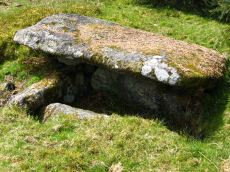
Crockern Tor Cist
OS Map: SX 61414 76055
HER: MDV57569
Megalithic Portal: 45816
PMD: Crockern Tor
Alternate name: Crockern Tor 1 Cist
ShortName: CT CrockernNW1
Butler Vol 5: p.32 & Fig.11
DPD page: 110
Notes: "Remains of a small cairn with cist on a moderate W slope in open grassland at SX 61407604 overlooking the West Dart in Crockern Newtake. It has been robbed heavily, leaving only one cist slab and fragments of the cairn material. The slab is restangular in side view and in section, firmly embedded on edge, measuring 1.2m long 0.48m high and 0.15m thick. It is aligned NW to SE." Butler Vol 5 p. 32. Lethbridge diagram and photo p.110.
Nearby sites: SX 61414 76055
Distance: 1.67km
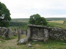
Dunnabridge Pound
Prehistoric Dartmoor Walks: Dartmoor Site: Dunnabridge Pound
OS Map: SX 6462 7465
HER: MDV6272
Megalithic Portal: 10635
PMD: Dunnabridge Pound
ShortName: PD Dunnabridge
Notes: Dunnabridge Pound probably has its origins in the prehistoric period as evidenced by the slight traces of hut circles within it. The pound underwent reconstruction in the medieval period and was used in the drifts to hold cattle found illegally pasturing on the moors. It was from this usage that the Judge's Chair got its name. "It occupies 0.9ha on a slight S slope, and is of rather oval form with greatest diameters of 110m by 122m. It is enclosed by a drystone wall 1.9m high and about 1m thick at the base, tapering towards the top. The material is mostly medium size moor stones with some large blocks and upright slabs incorporated at the base. The uneven interior is slightly raised at the southern perimeter and cut into the slope on the north, accompanied by a spread of stones, 1.5m long and 0.3m high, extending from the inner face and up to 0.6m high. The only entrance to be seen is the gated one on the S." See also, Legendary Dartmoor: Dunnabridge Pound
Nearby sites: SX 6462 7465
Distance: 1.89km
Dunnabridge Common Platform Cairn Circle and Cist
Prehistoric Dartmoor Walks: Dartmoor Site: Lakehead Hill
OS Map: SX 63585 75470
HER: MDV5952
Megalithic Portal: 37603
PMD: Smith Hill
Alternate name: Bellever Tor 9 Platform Cairn Circle and Cist
ShortName: CT Bellever 9
Butler map: 27.20.9
DPD page: 120
Grinsell: LYD 65
Turner: E37
Barrow Report: 58
Notes: Lethbridge Cist 3 diagram p.119 and photo bottom p.120. Butler Bellever Tor (Cairn 9) - Vol. 2. Map 27.20.9 (diagram p52-3). See also: Dartmoor Explorations: Antiquities of Black Newtake and Environs
Nearby sites: SX 63585 75470
Distance: 0.89km
Dunnabridge Pound Farm Newtake Cist
Prehistoric Dartmoor Walks: Dartmoor Site: Lakehead Hill
OS Map: SX 64086 75691
HER: MDV5891
Megalithic Portal: 45751
PMD: Dunnabridge Newtake
Alternate name: Bellever Tor 10 Cist
ShortName: CT Bellever10
Butler map: 27.20.10
Butler Vol 5: p.60 & Fig.39
DPD page: 121
Grinsell: LYD 66
Barrow Report: 59
Notes: Only one side of this cist remains. Further coverage on Lakehead Hill page. Lethbridge Cist 4 diagram p.119 and photo top p.121. Butler Bellever Tor - Vol. 2. Map 27.20.10 (Cairn 10 diagram pp.52-3). See also: Dartmoor Explorations: Antiquities of Black Newtake and Environs
Nearby sites: SX 64086 75691
Distance: 1.43km
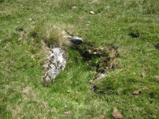
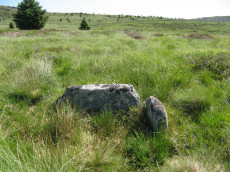
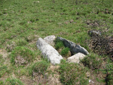
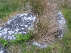
Muddilake Newtake Reported Cist
OS Map: SX 62654 75194
HER: MDV5893
Megalithic Portal: 45745
PMD: Muddilake Newtake
ShortName: CT:Muddilake
Grinsell: LYD 105
Turner: A21
Barrow Report: 58
Notes: NMR states "A hut circle, not a cairn circle". This is almost certainly not a cist. "The measurements do not conform to those of Prowse but nothing else can be seen in the vicinity. It is most unlikely that these stones represent the remains of a cist, but are a natural occurrence." (see also duplicate HER record 5894 and SiteID=2547). This "cist" entry was listed by Dixon, however, it seems a dubious entry. This is not listed by Butler, the relevant map is Vol. 2. Map 29.9.
Nearby sites: SX 62654 75194
Distance: 0.16km
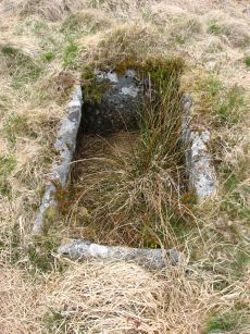
Roundhill, East of Summit Cist
OS Map: SX 61164 74413
HER: MDV6257
Megalithic Portal: 45681
PMD: Round Hill E.
Alternate name: Round Hill Summit 2 Cist
ShortName: CT Roundhill 2
Butler map: 65.1.2
DPD page: 105
Grinsell: LYD 79
Barrow Report: 31 44
Notes: "A well preserved cist, situated on a slight east-facing slope just off the crest of a rounded hilltop. It stands in isolation on a generally stone-free area of rough moorland pasture. The side slabs are each 1.2m long and up to 0.3m thick and the end slabs are 0.55m long, 0.15m wide and 0.4m long, 0.1m wide respectively. The coverstone is up to 1.6m long, 0.9m wide and 0.2m thick. There are no surface indications of either a cairn or mound around the cist." Lethbridge p.103 diagram Cist(B), photo bottom p.105. Butler Round Hill Summit 2 (Cist 2) - Vol. 4. Map 65.1 (p.227-9, diagram of Round Hill cairns p.228).
Nearby sites: SX 61164 74413
Distance: 1.76km
Roundhill, Near Summit Cist
OS Map: SX 61046 74428
HER: MDV6217
Megalithic Portal: 45682
PMD: Round Hill Summit W.
Alternate name: Round Hill Summit 1 Cist
ShortName: CT Roundhill 1
Butler map: 65.1.1
DPD page: 105
Grinsell: LYD 78
Barrow Report: 31 44
Notes: Butler Round Hill Summit 1 - Vol. 4. Map 65.1 (p.227-9, diagram of Round Hill cairns p.228). Lethbridge p.103 diagram Cist(A), photo top p.105.
Nearby sites: SX 61046 74428
Distance: 1.86km