
Turner Stone Circles

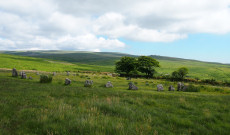
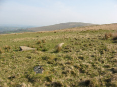
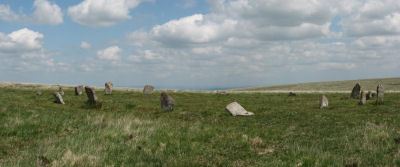
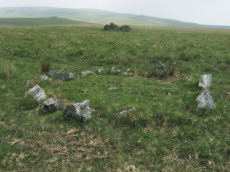
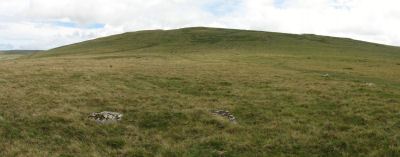
Photo: Trowlesworthy Warren (E) Cairn Circle
Turner in 1990 made one of the first serious attempts to classify Ring Cairns and Stone Circles. This work included a category G for stone circles defined as "rings of free-standing orthostats without any central features". Traditionally stone circles are defined as monuments that have no obvious funerary purpose and that stand alone as a circle of stones. This definition excludes circles associated with stone rows or that are thought to be cairn structures. However, Turner in his category G included stone circles that are attached to stone rows but do not have obvious cairns and also those circles with no visible cairn or cist which most other authors today would probably term as cairn circles. There are a number of problems with Turner's approach and on this website we use the more accepted traditional definition of a stone circle. However Turner's list of stone circles does include a number of prominent monuments that members of the public would probably call stone circles and it may also be of use to researchers and for those reasons we make it available here. For a more detailed discussion of the difference between stone circles and cairn circles see Guide to Dartmoor Stone Circles.
The following Turner listing of stone circles is ordered by size of monument. The entry for G2 and G4 are the Grey Wethers north and south stone circles respectively. Turner included a separate Gii listing for Multiple Stone circles, these are the Yellowmead and Shovel Down Four Fold circles which are listed last at G30 and G31. All of the following entries will also be found correctly listed as Stone Circles or Cairn Circles in the following listings:
Bibliography & references
Butler, J. Dartmoor Atlas of Antiquities: Vol. 5. - The Second Millennium B.C. (Devon Books, 1997)
Gerrard, Sandy, English Heritage Book of Dartmoor: Landscapes Through Time, (1997)
Grinsell, L.V., Dartmoor Barrows, Devon Archaeological Society Proceedings No. 36 (1978)
Newman, Phil The Field Archaeology of Dartmoor (English Heritage, 2011)
Pettit, Paul. Prehistoric Dartmoor (David & Charles, 1974)
Turner, J.R., Ring Cairns, stone circles and related monuments on Dartmoor, D.A.S.P. No. 48 pp. 27-86 (1990)
Worth, R.H. Worth's Dartmoor (David & Charles, 1971)
About the Database Listings
Details of archaeological sites used to be kept in the Sites and Monuments Records (SMRs). These are now held in National Monument Records (NMRs) maintained by English Heritage although these in turn are being merged into Historic Environment Records (HERs). The NMRs contains details of the site and will often include field notes, a limited bibliography and other useful information. Another rich source of such information is Bill Radcliffe's Prehistoric Monuments of Dartmoor (PMD) website. The records below were compiled independently from books and journals and then matched to the NMR records and then cross-referenced with any corresponding PMD records to ensure accuracy. Each record has a link to corresponding NMR and PMD records, a link to the location on the Ordnance Survey map, a photo (if available) and a link to relevant coverage on Prehistoric Dartmoor Walks and a link giving a listing of nearby sites. The HER records are not included as they do not yet have much information but they can be looked up via the PMD records. The author would like to thank Bill Radcliffe for the helpful correspondence whilst checking records. See also: Database and Web Search Tools
- NMR = Pastscape National Monument Record
- HER = Historic Environment Record
- PMD = Prehistoric Monuments of Dartmoor Record
- DPD = Discover Prehistoric Dartmoor page number
- Short Name is named used in GPS listings
Default listing is by Turner number which is approximately largest first. Click here to order instead by: Site Name, OS, Monument Type, Turner Number.
Brisworthy Stone Circle
Prehistoric Dartmoor Walks: Dartmoor Site: Brisworthy Stone Circle
OS Map: SX 56467 65495
HER: MDV3983
Megalithic Portal: 542
PMD: Brisworthy Stone Circle
Short Name: SC Brisworthy
Butler map: 49.18
Turner: G8
DPD: 35
Barrow Report: 29 35
Dimensions (m): 24.0 x 27.0
Notes: The Brisworthy circle underwent major reconstruction carried out by Breton and the Barrow Committee in 1909. At the time only 4 stones remained standing whilst another 21 were lying roughly in place. Some 15 stones out of 40 are missing, no doubt robbed for nearby enclosures and walls. A low rubble bank surrounds the circle which can be seen on LIDAR data. This is discussed in detail in the article 'Dartmoor Site: Brisworthy Stone Circle' linked above in this listing.
See also: Legendary Dartmoor: Dartmoor's Brisworthy Circle. Lethbridge p.34-35. Diagram p.34 site 1.
Nearest Bus Stop: Meavy Primary School (2.6 km) [Route: 56]
Nearby sites: SX 56467 65495
Buckland Ford Cairn Circle
OS Map: SX 6574 6604
HER: MDV5187
Megalithic Portal: 717
Short Name: CC:Buckland Fd
Butler map: 57.23
Grinsell: LYD 107
Turner: G19
DPD: 87
Barrow Report: 65
Dimensions (m): c.9.0 x 0
Notes: Probable cairn circle. "A small, probably sepulchral, stone circle. It consists of 14 stones arranged in an 'egg' shape. The long axis is 9.9 metres aligned due east by 8.2m transversely. A further 7 stones are in close proximity but may not be associated. There is no trace of a cist or cairn." "It is largely obscured by long tussocky grass and the absence of a discernible cairn or cist makes it an unusual site by Dartmoor standards".
Nearest Bus Stop: Dartmeet Badgers Holt (7.3 km) [Route: 172]
Nearby sites: SX 6574 6604
Buttern Hill Stone Circle
OS Map: SX 64949 88481
HER: MDV4371
Megalithic Portal: 724
PMD: Buttern Hill Stone Circle
Short Name: SC Buttern 1
Turner: G7
DPD: 147
Dimensions (m): 24.8
Notes: NNE of Scorhill about 2Km. "The remains of a Bronze Age stone circle situated on level ground overlooking the valley of the North Teign River and Whitemoor Marsh. The stone circle measures 24.8 metres in diameter and is denoted by five upright granite slabs standing up to 0.76 metres high. A further 12 recumbent stones lie where they have fallen." Also known as the Throwleigh circle. According to R.N. Worth, although not confirmed since, there was "a small cairn between five and six yards in from the southern edge" and also there is a companion circle a short distance on the slope westward, 60 feet in diameter consisting of four stones with a possible large central pillar, see. The Stone Rows of Dartmoor - Part 3. Breton p.58. - Throwleigh Circle.
Nearest Bus Stop (Minor): Wonson Telephone Box (2.6 km) [Route: 670]
Nearest Bus Stop (Major): Ramsley (4.7 km) [Route: 670,671,6A]
Nearby sites: SX 64949 88481
Challacombe Down Cairn Circle
Prehistoric Dartmoor Walks: Dartmoor Site: Challacombe Down Triple Stone Row
OS Map: SX 6898 8084
HER: MDV49462
Megalithic Portal: 1819
PMD: Challacombe Down Stone Row
Short Name: CC Challacombe
Butler map: 24.3
Butler Vol 5: p.239 & Fig.169
Turner: G20
Dimensions (m): 8
Notes: Dubious site - the current arrangement relates to stones placed during restoration of the stone row. See Worth (1953) p. 226 on how "nothing coherent" came of attempts to re-erect stones scattered to the west of the north end of the row which gave the appearance of a stone circle.
Nearest Bus Stop: Warren House Inn (1.5 km) [Route: 171]
Nearby sites: SX 6898 8084
Cholwich Town (site of) Cairn Circle
OS Map: SX 5846 6225
HER: MDV49508
Megalithic Portal: 770
PMD: Cholwich Town Stone Row
Alternate name: Cholwichtown stone row Cairn Circle
Short Name: CCxCholwich
Butler map: 48.
Grinsell: COR 5
Turner: G27
Dimensions (m): 4.9
Notes: Site of former cairn circle. "the row, extending over 700ft, consisted of uprights 2-3ft. high and 3ft. apart, the circle, at the northern end of the row, was 15ft. in diameter with seven upright stones. The site was excavated in 1961, and the sockets of many missing stones were found, also a pit 8ft. in diameter in the centre of the circle. "
Nearest Bus Stop: Lee Moor Clearview (1.3 km) [Route: 59]
Nearby sites: SX 5846 6225
Down Ridge Stone Circle
OS Map: SX 65516 72084
HER: MDV6400
Megalithic Portal: 863
PMD: Down Ridge Stone Circle
Short Name: SC DownRidge
Turner: G9
DPD: 92
Dimensions (m): 25.0
Notes: Also known as Hexworthy Circle. "situated on a gentle north facing slope overlooking the valley of the River Dart. The stone circle measures 25 meters in diameter and is denoted by five upright granite slabs, standing up to 1.45 meters high, which are confined to its south western sector. A further six recumbent stones lie where they have fallen. The stone circle was partially excavated in 1904 by the Dartmoor Exploration Committee and their work revealed the original ground surface covered with charcoal. An associated outlying standing stone is located 85 meters south-east of the stone circle and survives as a triangular shaped block up to 0.86 meters high." [HER MDV6400]. For photos of this site, see: Megalithic Portal: Down Ridge - Stone Circle
Nearest Bus Stop: Dartmeet Badgers Holt (2.1 km) [Route: 172]
Nearby sites: SX 65516 72084
Erme Cairn Circle
Prehistoric Dartmoor Walks: Dartmoor Site: Upper Erme Stone Row & Cairn Circle
OS Map: SX 63517 64442
HER: MDV4310
Megalithic Portal: 533
Alternate name: Upper Erme stone row Cairn Circle
Short Name: CC The Dancers
Butler map: 55.7.1
Grinsell: COR 10
Turner: G16
DPD: 71
Dimensions (m): 15.8 x 0.3
Notes: An impressive cairn circle (often referred to as a stone circle) on Stall Moor which is also known as The Dancers, Kiss in the Ring or Stall Moor Circle. "Round barrow with retaining circle at south end of longest Dartmoor stone row. Diameter 16m, height of mound 0.3m." Lethbridge pp.70-71, diagram p.71
Nearest Bus Stop: Cornwood Crossways (5.7 km) [Route: 59]
Nearby sites: SX 63517 64442
Fernworthy Stone Circle
Prehistoric Dartmoor Walks: Dartmoor Site: Fernworthy Ceremonial Complex
OS Map: SX 65486 84126
HER: MDV6534
Megalithic Portal: 530
PMD: Fernworthy Stone Circle
Short Name: SC Fernworthy
Turner: G13
DPD: 138
Dimensions (m): 19.3
Notes: The Fernworthy circle is part of a group of ceremonial monuments including 3 stone rows and 5 cairns that may once have rivalled Merrivale and Shovel Down as ceremonial centres. The site is in a small clearing in Fernworthy Forrest off the path to Teignhead Farm. The circle is remarkably intact with all but 2 stones still in their original places ... It is 20m in diameter and consists of 27 small stones. The stone rows and cairns probably came later and surround the site. The circle was excavated by the Dartmoor Exploration Committee in 1897. They found that the interior of the circle was covered in a layer of charcoal suggesting that it had been the scene of very many fires - perhaps funeral pyres or feasts. See also Legendary Dartmoor: Dartmoor's Fernworthy Stone. DNP Post 3D. Breton p.66-67
Nearest Bus Stop: Warren House Inn (3.7 km) [Route: 171]
Nearby sites: SX 65486 84126
Glasscombe Corner Cairn Circle
Prehistoric Dartmoor Walks: Dartmoor Walk: The Erme East stone rows
OS Map: SX 66100 60802
HER: MDV49561
Megalithic Portal: 1951
PMD: Glasscombe Corner Stone Row
Alternate name: Glasscombe Corner stone row Cairn Circle
Short Name: CN GlasscombW1
Butler map: 56.12
Grinsell: UGB 5
Turner: G28
Dimensions (m): 3.5
Notes: Lower end of stone row. "A stone row, 300 yds S 41o W from Glasscombe Corner. The southern 368 feet are a double row and the northern 212 feet 6 inches a single row. The northern part has lost no stones and the change from double to single is abrupt and complete. At the S.W. end are the remains of a cairn and at the NE. end is a retaining circle with many of the stones fallen. It would appear thus that there was a grave at either end of the row. "
Nearest Bus Stop: South Brent Pool Park (4.2 km) [Route: 38]
Nearby sites: SX 66100 60802
Grey Wethers (N) Stone Circle
Prehistoric Dartmoor Walks: Dartmoor Site: Grey Wethers Double Stone Circle
OS Map: SX 63875 83161
HER: MDV6758
Megalithic Portal: 532
PMD: Grey Wethers Stone Circles
Short Name: SC Grey Weth N
Turner: G4
DPD: 134
Dimensions (m): 31.5
Notes: "Northern stone circle of the pair known collectively as The Grey Wethers. This circle measures 31.5 metres in diameter and is denoted by 20 upright granite slabs with an average height of 1.1 metres. Excavations carried out by the Dartmoor Exploration Committee towards the end of the 19th century revealed a layer of charcoal covering the original ground surface. A shallow trench visible leading through the southern circle may be the result of this excavation. The circle was restored at this time". Grinsell [Folklore 1976]: The stones turn round at sunrise. King 1873, 780; St Leger Gordon 1972, 71-2.
Nearest Bus Stop: Warren House Inn (4.2 km) [Route: 171]
Nearby sites: SX 63875 83161
Grey Wethers (S) Stone Circle
Prehistoric Dartmoor Walks: Dartmoor Site: Grey Wethers Double Stone Circle
OS Map: SX 63874 83121
HER: MDV6759
Megalithic Portal: 532
PMD: Grey Wethers Stone Circles
Short Name: SC Grey Weth S
Turner: G2
DPD: 134
Dimensions (m): 33.0
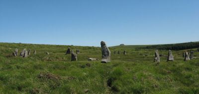
Notes: This site is one of the most impressive on Dartmoor. The circles were restored in 1909 by Burnard. At the time only 9 stones remained standing in the north circle and 7 in the south circle. It is thought that the reconstruction is fairly accurate. The circles are separated by a few meters and are almost identical. Both circles have 30 stones and diameters very close to 33 m and they are within 2 degrees of being on an exact north to south alignment. The slight differences between the two circles could even be a result of the restoration. Apparently "wether" is an old English name for sheep and legend has it that a drunken farmer leaving the Warren House Inn was persuaded that the Grey Wethers were a desirable flock for sale! See also, Legendary Dartmoor: Grey Wethers. Grinsell [Folklore 1976]: The stones turn round at sunrise. King 1873, 780; St Leger Gordon 1972, 71-2.
Nearest Bus Stop: Warren House Inn (4.2 km) [Route: 171]
Nearby sites: SX 63874 83121
Joan Ford's Newtake Cairn Circle
OS Map: SX 63033 72172
HER: MDV6261
Megalithic Portal: 3296
Alternate name: Joan Ford's Newtake 2 Cairn Circle
Short Name: CC Joan Fords
Butler map: 63.3.2
Grinsell: LYD 91
Turner: G22
Barrow Report: 30
Dimensions (m): 6.0 x 0.3
Notes: "A stone circle with six identifiable erect or leaning stones. One forms the E post of the gateway, the west post, 7ft high, stands outside the circumference. It is because of its small diameter, without doubt a retaining circle; any internal features such as a central hollow or possible kistvean have been obliterated by the wall builders." Turner Stone Circle G22. Bar Rep 30.
Nearest Bus Stop: Two Bridges Hotel (3.4 km) [Route: 98,171,172]
Nearby sites: SX 63033 72172
Lakehead Hill Cairn Circle
Prehistoric Dartmoor Walks: Dartmoor Site: Lakehead Hill
OS Map: SX 64351 77493
HER: MDV52762
Megalithic Portal: 24365
Alternate name: Lakehead Hill 5 Cairn Circle
Short Name: CC Lakehead 5
Butler map: 27.19.5
Grinsell: LYD 55
Turner: G24
DPD: 117
Barrow Report: 54
Dimensions (m): 6.8
Notes: Butler Cairn 5. Tuner lists this as G24 Stone Circle. However, it is clear from its size and location near other Ring Settings that it is in fact better described as a Ring Setting despite having no visible internal structure. In these listings we will leave it as a cairn circle. HER: A ring cairn lying on a gentle slope near the summit of Lakehead Hill. The cairn is defined by a circle of edge set stones which measure 7.8 metres in diameter and stand up to 0.9 metres high. DEC Report 3: A second small kistvaen within a circle exists on the west side of Lake Head Hill, and was examined, but nothing was found in it. The circle about it is tolerably complete and the stone chest has lost only one of the side-stones ; but it is very small. Apparently a small stone row led from it. Near the kistvaen is a circle of stones enclosing a cairn, but no kistvaen. From the circle perhaps a stone row led away east, but only three stones remain in line. Lethbridge diagram p.114 and photo top p.117.
Nearest Bus Stop: Postbridge Bellever (1.2 km) [Route: 98]
Nearby sites: SX 64351 77493
Langstone Moor Stone Circle
Prehistoric Dartmoor Walks: Dartmoor Site: Langstone Moor Stone Circle, Stone Row & Settlements
OS Map: SX 55638 78204
HER: MDV4226
Megalithic Portal: 1062
PMD: Langstone Moor Stone Circle
Short Name: SC Langstone
Butler map: 30.10
Turner: G10
DPD: 14
Dimensions (m): 20.4
Notes: The Langstone standing stone and also the stone circle were used for target practice by American troops who were stationed nearby during the Second World War. Bullet holes can be seen on the Langstone standing stone and the circle was sadly smashed to smithereens. The Langstone Moor Stone circle had been restored in 1894 when all of the stones were re-erected in their original socket holes. Today only 3 stones remain intact with 10 having been destroyed and the rest overturned during World War Two. The debris of the former stones remain in place. Pre-war photos give a sense of how spectacular this site used to be. The original restored circle consisted of 16 stones in a 20.9m circle. The original survey by the Dartmoor Exploration Committee suggested that there might have originally been a secondary concentric circle consisting of elvan rather than granite stones although the evidence for this today is unclear (see Extract from the Second Report of the D.E.C.). Breton (p.18): It was discovered as recently as 1894. Not a single stone was then standing, but fortunately none had been taken away or even mutilated. The Duke of Bedford kindly allowed the stones to be re-erected, and supplied the men to do the work, which was directed by the Rev S. Baring-Gould and Mr. Robert Burnard. It has 16 stones, and its diameter is about 60 ft. There was originally another circle outside this one, of which only two or three stones remain. Further coverage can be found on Legendary Dartmoor: Dartmoor's Prehistoric Langstone Moor. Lethbridge p14, diagram p13.
Nearest Bus Stop: Merrivale Dartmoor Inn (3.1 km) [Route: 98,171,172]
Nearby sites: SX 55638 78204
Little Hound Tor (or White Moor) Stone Circle
Prehistoric Dartmoor Walks: Dartmoor Site: Little Hound Tor Stone Circle
OS Map: SX 63285 89611
HER: MDV4374
Megalithic Portal: 528
PMD: White Moor Stone Circle
Short Name: SC White Moor
Turner: G11
DPD: 154
Dimensions (m): 20.2
Notes: The circle is in good condition today but only 13 stones remained standing when the Dartmoor Exploration Committee re-erected 5 of the stones in 1896. The site is a fairly accurate circle of circumference 20.2m. A cairn lies close to the circle, a heather covered mound about 8.5m across. The White Moor stone lies 160m to the SE of the circle and it is thought to be contemporary with the circle but probably out of position having been re-erected at some point. It is now a boundary marker. Breton p.52. See also, Legendary Dartmoor: Dartmoor's Bronze Age Landscape of Whitmoor.
Nearest Bus Stop (Minor): Throwleigh Cross (3.7 km) [Route: 670]
Nearest Bus Stop (Major): Ramsley (3.9 km) [Route: 670,671,6A]
Nearby sites: SX 63285 89611
Mardon Down Stone Circle
Prehistoric Dartmoor Walks: Dartmoor Site: Mardon Down Stone Circle & Cairns
OS Map: SX 76764 87203
HER: MDV8289
Megalithic Portal: 3376
PMD: Mardon Down Stone Circle
Short Name: SC Mardon Down
Butler Vol 5: p.148 & Fig.90
Turner: G1
DPD: 149
Dimensions (m): 38.0
Notes: Mardon Down stone circle is the biggest by circumference on Dartmoor with a diameter of 38m. The site would have been impressive in its day and is one of the only ones sited on the top of high ground and has a fine view of the surrounding area. Today the circle is fairly dilapidated. Six stones remain upright and another 16 lie roughly in place. There are two massive megaliths one of which is on the north-western part of the circle. A short arc of seven stones remains in position on the south-east of the circle. The circle was first described by Dr Milles in 1772 who reported around 70 stones. Butler suggests it probably originally consisted of around 61 stones many of which are probably buried under the peat where they originally fell although some have no doubt been robbed out.
Nearest Bus Stop: Moretonhampstead Court Street Car Park (2.0 km) [Route: 171,173]
Nearby sites: SX 76764 87203
Merrivale Stone Circle
Prehistoric Dartmoor Walks: Dartmoor Site: Merrivale Ceremonial Complex [Photo Set 2]
OS Map: SX 55361 74641
HER: MDV4998
Megalithic Portal: 116
PMD: Merrivale Stone Circle
Short Name: SC Merrivale
Turner: G14
DPD: 17
Dimensions (m): 18.6 x 20.2
Notes: "A stone circle with a diameter of 20.0m. measured from northeast to southwest and 18.0m from northwest to southeast. It is formed by eleven stones spaced between 2.7m and 6.7m. apart and from 0.3m. to 0.5m. high. Three of the stones are of post type and eight are upright slabs. An additional stone, 7.5m. from the northeast side and 0.3m high, is angled towards the circle and may be quite unassociated". According to Breton (p.14) It formerly contained a kistvaen. No other accounts make this claim but the DEC report does mention shallow pits. Baring Gould states: Examination of some depressions in the surface of the turf found several pits dug to a depth of 12 - 18 inches in one of which was a flint flake. These had apparently been the socket holes for standing stones which had been removed to serve as gate posts or reused in the construction of a new-take wall nearby. See also Legendary Dartmoor: Merrivale Ceremonial Complex. Lethbridge pp.16-18, diagram 16.
Nearest Bus Stop: Merrivale Dartmoor Inn (0.7 km) [Route: 98,171,172]
Nearby sites: SX 55361 74641
Nine Stones, Belstone Cairn Circle
Prehistoric Dartmoor Walks: Dartmoor Site: Nine Maidens Cairn Circle, Belstone Tor
OS Map: SX 61232 92849
HER: MDV6865
Megalithic Portal: 535
PMD: The Nine Stones
Alternate name: Nine Stones Cairn Circle
Short Name: CC Nine Stones
Butler map: 40.13
Grinsell: BEL 1
Turner: G23
DPD: 156
Barrow Report: 21 42
Dimensions (m): 7.2 x 0.6
Notes: The "Nine Stones" cairn circle "survives as a ring of at least 16 upright stones, standing up to 0.7 metres high, surrounding a slightly raised 7 metre diameter internal area". "A loose granite boulder in the centre of the circle may cover a cist; and there are vestiges of a mound around it. Well preserved." See also, Legendary Dartmoor: The Nine Maidens
Grinsell [Folklore 1976]: The retaining circle of a cairn, of which seventeen stones are now visible. Maidens turned into stone for dancing on the Sabbath, they still dance at noon. King 1850; Cresswell 1924,58; St Leger Gordon 1972, 70. There is a poetic version in Eden Phillpotts, Book of Avis .
Nearest Bus Stop (Minor): Belstone Car Park (1.3 km) [Route: 670]
Nearest Bus Stop (Major): Belstone Tongue End Cross (2.3 km) [Route: 178,670,671,6A]
Nearby sites: SX 61232 92849
Ringmoor Down Cairn Circle
OS Map: SX 56157 65947
HER: MDV4029
Megalithic Portal: 22947
Alternate name: Ringmoor Down 3 Cairn Circle
Short Name: CC Ringmoor 3
Butler map: 49.21.3
Grinsell: SHE 18
Turner: G29
DPD: 36
Barrow Report: 63
Dimensions (m): 3.5
Notes: Located about 230m NW of the cairn circle that terminates the Ringmoor Down stone row. "An 11ft 2ins diameter cairn circle composed of fourteen stones of which four have fallen over. Stones of quartz-schorl, not granite." "This feature has the semblance of having been recently created. The stones are mostly loose and irregularly spaced. As a monument type it appears to be unique on Dartmoor. It should not be considered of great antiquity." For a photo, see: Stone-Circles.org.uk: Ringmoor Cairn. Lethbridge kerb circle p.34-36. Diagram 34 site 4.
Nearest Bus Stop: Meavy Primary School (2.1 km) [Route: 56]
Nearby sites: SX 56157 65947
Rook Tor 1 Cairn Circle
OS Map: SX 6127 6148
HER: MDV49463
Megalithic Portal: 3445
Short Name: CC:Rook Tor 1
Turner: G21
Dimensions (m): 7.5
Notes: Turner G21: 10 stones standing, one a boulder (Turner). The closest possible NMR entry that could fit refers to natural boulders. Butler refers to a possible cairn at SX60236153 a semi-circle of slabs amongst the rocks of Rook Tor are obviously artificially set - remains suggest the site of a cairn, entirely demolished but for the retaining circle. (Butler Vol. 3. p.182). Are there two features separated by 1 km or is there an error in one of these grid references? See also: Rook Tor 2
Nearest Bus Stop: Cornwood Crossways (2.1 km) [Route: 59]
Nearby sites: SX 6127 6148
Scorhill Stone Circle
Prehistoric Dartmoor Walks: Dartmoor Site: Scorhill Stone Circle
OS Map: SX 65458 87399
HER: MDV6122
Megalithic Portal: 540
PMD: Scorhill Stone Circle
Short Name: SC Scorhill
Butler map: 38.8
Butler Vol 5: p.249 & Fig.175
Turner: G6
DPD: 146
Dimensions (m): 27.0
Notes: One of the most impressive stone circles on Dartmoor and one of the few that has not been restored. The circle consists of 23 granite slabs up to 2.5m high with a further 11 recumbent stones. The circle is not the largest in terms of diameter but it is the most striking circle on Dartmoor with some of the largest standing stones. See also, Legendary Dartmoor: Scorhill Stone Circle and HER MDV6122
Nearest Bus Stop (Minor): Wonson Telephone Box (2.9 km) [Route: 670]
Nearest Bus Stop (Major): Chagford The Square (4.6 km) [Route: 173,178,671]
Nearby sites: SX 65458 87399
Shaugh Moor (N) Cairn Circle
OS Map: SX 55419 63496
HER: MDV5596
Megalithic Portal: 3458
Alternate name: Shaugh Moor N.1 Cairn Circle
Short Name: CC ShaughMo N1
Turner: G18
Dimensions (m): 8.2
Notes: "Whether the stones represent the remnants of a stone circle, a cairn circle, or even a hut is debateable". "The remains of a circle of stones lie on a north-west facing hill slope at 256m above OD on unenclosed moorland. It survives as a partial ring of five boulder and stones with an off-centre earthfast boulder; the overall diameter was approximately 10.0m to 10.6m across. The largest of the two slabs which remain upright is 0.8m high, 1.7m wide and 0.3m thick."
Nearest Bus Stop: Shaugh Prior White Thorn Inn (1.3 km) [Route: 59]
Nearby sites: SX 55419 63496
Shaugh Moor (S) Cairn Circle
OS Map: SX 55419 63427
HER: MDV49564
Megalithic Portal: 52567
PMD: Shaugh Moor Stone Row
Alternate name: Shaugh Moor stone row Cairn Circle
Short Name: CC ShaughMoorS
Butler map: 48.5
Grinsell: SHA 41
Turner: G17
DPD: 55
Dimensions (m): 13.0 or 18.0
Notes: Cairn circle at the southern end of the Shaugh Moor stone row. "An egg-shaped ring of stone uprights". "Only an arc of four clearly identifiable stones survive in the circle; they are a maximum 0.3m high and suggest an approximate circle diameter of 15.0m. There are a number of buried and semi-buried stones traceable but their relationship to the circle is unclear". Lethbridge p.54-55, diagram p.55
Nearest Bus Stop: Shaugh Prior White Thorn Inn (1.3 km) [Route: 59]
Nearby sites: SX 55419 63427
Sherberton Stone Circle
OS Map: SX 63946 73187
HER: MDV6290
Megalithic Portal: 1252
PMD: Sherberton Stone Circle
Short Name: SC Sherberton
Turner: G5
DPD: 101
Dimensions (m): 29.5
Notes: Remains of a 97 ft diameter stone circle with a stone wall passing through its western side. "Nine of the original stones are still standing, plus one larger stone which is incorporated in the remains of the old wall which bisects the western extremity of the circle. This stone appears to have been removed from the original circumference, and its height is 1.4m. The remaining nine stones range in height from 0.3m to 0.75m. The original circle appears to have been c. 30m across, although no stones appear to the west of the old wall. The length of the 2 fallen stones at the southern end is 2.6m and 2.4m". Lethbridge p.101, diagram p.99 and p.100. Breton (p.20): It was formerly a fine circle, but it has been mutilated to build the walls, and only seven stones now remain. Some of the stones are used as the gate posts, others are in the wall. The late Rev S Baring-Gould told me that he found, many years ago, the late Mr Coaker's father (of Sherberton Farm) removing the stones of this circle. Mr Baring-Gould explained to him the value of the circle and not another stone was touched.
Nearest Bus Stop: Dartmeet Badgers Holt (3.3 km) [Route: 172]
Nearby sites: SX 63946 73187
Shovel Down Stone Circle
Prehistoric Dartmoor Walks: Dartmoor Site: Shovel Down Ceremonial Complex
OS Map: SX 65829 86196
HER: MDV29944
Megalithic Portal: 1259
PMD: Shovel Down Stone Circle
Short Name: SC Shovel Down
Butler map: 36.6
Turner: G15
DPD: 139
Dimensions (m): 16
Notes: "The remains of an alleged stone circle lie on the gentle NE facing slope of Shovel Down 200m SW of Batworthy Corner. Three upright stones, between 0.3m and 0.75m high, are visible. The two close-set NE stones display smaller packing stones in the erosion hollows at their bases. The third stone is partly obscured by the bank of the South Hill Leat (SX 68 SW 97). It is possible that these stones constitute the remains of a stone circle however, no such feature is noted in the antiquarian records so it must remain a doubtful site". In fact a sketch of the Shovel Down rows made by Wilkinson in 1860 marks and illustrates "stones" at the location of the stone circle. For a photo, see Megalithic Portal: Shovel Down NW stone circle. Lethbridge pp.139-145, diagram p.139.
Nearest Bus Stop (Minor): Wonson Telephone Box (3.7 km) [Route: 670]
Nearest Bus Stop (Major): Chagford The Square (4.4 km) [Route: 173,178,671]
Nearby sites: SX 65829 86196
Shovel Down Fourfold Cairn Circle
Prehistoric Dartmoor Walks: Dartmoor Site: Shovel Down Ceremonial Complex
OS Map: SX 65958 86025
HER: MDV6158
Megalithic Portal: 3464
PMD: Fourfold Circle
Alternate name: Fourfold Circle Cairn Circle
Short Name: CC Shovel4Fold
Butler map: 36.7
Grinsell: GID 3
Turner: G31
DPD: 143
Barrow Report: 56
Dimensions (m): c.9.0
Notes: "Fourfold Circle a sub-circular configuration of four apparently concentric stone rings. The outer ring has a diameter of 9m, the others have diameters of 6.4m, 4.7m and 2.4m respectively. The monument comprises 29 visible stones. Most are approximately 0.3m in height although they vary from 0.1-0.55m. The middle two rings define the bottom and top of the scarp of a small earthern cairn apparently an integral part of the monument. It is most pronounced on the E (downslope side). In the centre is a roughly sub-circular pit measuring 1.3m by 0.7m and 0.45m deep; it is probably the remains of a badly robbed cist. On the N side are two large fallen stones. When upright they may have served as a focal point for the end of the stone row " Lethbridge 139-145, diagram p.139.
Nearest Bus Stop (Minor): Wonson Telephone Box (3.8 km) [Route: 670]
Nearest Bus Stop (Major): Chagford The Square (4.4 km) [Route: 173,178,671]
Nearby sites: SX 65958 86025
Sourton Tors Stone Circle
OS Map: SX 54683 89587
HER: MDV4626
Megalithic Portal: 3472
PMD: Sourton (Corn Ridge) Stone Circle
Short Name: SC Sourton Tor
Butler map: 43.6
Turner: G3
Dimensions (m): 32.0
Notes: "A stone circle, diameter about 110 ft and appearing to have comprised 32 stones of which all but six remain where they have fallen, has been discovered between Sourton Tors and Cornridge. In size it compares with the circles of the Grey Wethers and Scorhill". For a photo of this site, see: Megalithic Portal: Sourton Tors Stone Circle
Nearest Bus Stop: Sourton Windard Terrace (1.5 km) [Route: 118]
Nearby sites: SX 54683 89587

Stonetor Hill Cairn Circle
OS Map: SX 65244 85468
HER: MDV49461
Megalithic Portal: 52273
Alternate name: Stonetor Hill 1 Cairn Circle
Short Name: CC Stonetor 1
Turner: G12
DPD: 133
Dimensions (m): 20
Notes: Dubious site. "Two upright slabs situated in the shallow valley bottom above the headmire of the E arm of the Stonetor Brook. The slabs, 1.2m high, are positioned in line 1.0m apart and lie on the boundary of Gidleigh Parish and the Forest of Dartmoor, now Dartmoor Forest parish. The N face of the E stone has the letters 'GP' (Gidleigh parish). The S face is lichen covered. A deep water filled erosion hollow lies on the N side of these stones". Possibly site listed as Stone Circle G12 by Turner. For a photo of this site, see Boundary stone on Stonetor Hill
Nearest Bus Stop (Minor): Wonson Telephone Box (4.6 km) [Route: 670]
Nearest Bus Stop (Major): Warren House Inn (5.0 km) [Route: 171]
Nearby sites: SX 65244 85468
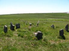
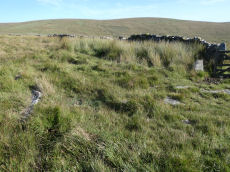
Trowlesworthy Warren (E) Cairn Circle
Prehistoric Dartmoor Walks: Dartmoor Site: Trowlesworthy, Settlements, Stone Row & Cairn Circle
OS Map: SX 57651 63983
HER: MDV49511
Megalithic Portal: 529
PMD: Trowlesworthy E Stone Row
Alternate name: Trowlesworthy stone row 1 Cairn Circle
Short Name: CC Trowles E
Butler map: 51.8.1
Butler Vol 5: p.229 & Fig.163
Grinsell: SHA 44
Turner: G25
DPD: 58
Dimensions (m): 6.6 x 0
Notes: Cairn circle at head of stone row. "The circle 6.5m. in diameter comprises eight orthostats from 0.7m. to 1.5m. high. In some cases the 'trig' stones are visible." "The alleged cairn at the head of the row comprises a ring of eight stones a maximum of 1.2m high with no evidence of a cist and very little to suggest the former presence of a cairn. It would seem more likely to represent the remains of a small stone circle albeit only 6.0 to 6.5m in diameter." See also, Legendary Dartmoor: The Pulpit. Lethbridge p.57-8, diagram p.58.
Nearest Bus Stop: Lee Moor Clearview (2.2 km) [Route: 59]
Nearby sites: SX 57651 63983
Trowlesworthy Warren (W) Cairn Circle
Prehistoric Dartmoor Walks: Dartmoor Site: Trowlesworthy, Settlements, Stone Row & Cairn Circle
OS Map: SX 57544 63986
HER: MDV49509
Megalithic Portal: 3517
PMD: Trowlesworthy W Stone Row
Alternate name: Trowlesworthy stone row 2 Cairn Circle
Short Name: CC Trowles W
Butler map: 51.8.2
Grinsell: SHA 43
Turner: G26
Dimensions (m): 5.5 x 0.3
Notes: This is a cairn circle at the east end of the Trowlesworthy Warren (W) stone row. "At the east is a 4.5m. diameter circle of 10 stones; average height 0.4m. There is no visible cairn or cist in the centre. Two upright stones immediately to the north west of the circle are probably associated. "
Nearest Bus Stop: Lee Moor Clearview (2.1 km) [Route: 59]
Nearby sites: SX 57544 63986
Yellowmead Fourfold Cairn Circle
Prehistoric Dartmoor Walks: Dartmoor Site: Yellowmead 4-fold Cairn Circle
OS Map: SX 57488 67846
HER: MDV3338
Megalithic Portal: 1371
PMD: Yellowmead Stone Circles
Alternate name: Yellowmead fourfold circle Cairn Circle
Short Name: CC Fourfold
Butler map: 47.14
Grinsell: SHE 4
Turner: G30
DPD: 31
Barrow Report: 41 56
Dimensions (m): 19.0 x 0
Notes: "A group of four concentric stone circles of which the innermost one is considered to be a cairn circle. Three stones were standing in 1921 when all the fallen stones were raised during restoration. There also appears to have been a stone row leading away from the stone circles." See also, Legendary Dartmoor: Yellowmead Stone Circle. Breton, see Megalithic circles on Yellowmead Down, Sheepstor (Heart of Dartmoor pp.89-91).
Nearest Bus Stop: Meavy Primary School (3.1 km) [Route: 56]
Nearby sites: SX 57488 67846