
Guide to the Monuments on Royal Hill and Ter Hill
Table of Ritual and Burial Monuments on Royal Hill and Ter Hill
The following table lists the records currently in this Guide Map. For an explantion of the Guide Maps and a table of all 62 Guide Maps, follow this link: Guide List Table. Introductory text will be added to each guide list in 2025. Notes on duplication and omissions will appear below the table once checks have been finalised.
Notes on possible duplications and omissions
Swincombe Ford Newtake 1 (duplicate): The HER record MDV59551 is a duplicate of MDV54431. The record originates with a description from Greeves in 1992 referring to a cist and retaining circle near the bridle path located at approximately SX 6345 7285. The HER entry MDV54431 relates to a cist that is not far from the path and broadly fits Greeve's description but is located at SX 63331 72990 (Garmin). The two grid references are 120m apart - but that is based on an estimate from 1992 and is arguably within margins of error for the day. No other cists are known near that path. This entry is a duplicate.Joan Ford's Newtake N.5: This mound was recorded by the current author. It may be a modern feature and as such may not qualify for the HER.
PS. These notes are to assist untangling complicated records and are neither permanent nor a criticism of the HER who do a fantastic job! The author finds it easier to systematically work through these records (2000+ of them) and add these notes, which are then to be communicated with the HER, if appropriate, it is a pragmatic way of dealing with lots of data without continually stopping and starting.
Royal Hill and Ter Hill Guide Map
Guidance for walkers: The monuments featured in this database are archaeological treasures and need to be protected and preserved - please do not disturb any sites. Please check access and firing times before visiting sites, not all sites listed are on open access land. Firing ranges and boundaries of open access areas are marked on the OL28 OS Dartmoor Explorer map. Please stick to the country code and consider giving support to the numerous agencies that help to keep Dartmoor a fabulous natural and historic environment!
List of Ritual and Burial Monuments on Royal Hill and Ter Hill
Sherberton Stone Circle
OS Map: SX 63946 73187
HER record: MDV6290
Megalithic Portal: 1252
PMD: Sherberton Stone Circle
ShortName: SC Sherberton
DPD page: 101
Turner: G5
Notes: Remains of a 97 ft diameter stone circle with a stone wall passing through its western side. "Nine of the original stones are still standing, plus one larger stone which is incorporated in the remains of the old wall which bisects the western extremity of the circle. This stone appears to have been removed from the original circumference, and its height is 1.4m. The remaining nine stones range in height from 0.3m to 0.75m. The original circle appears to have been c. 30m across, although no stones appear to the west of the old wall. The length of the 2 fallen stones at the southern end is 2.6m and 2.4m". Lethbridge p.101, diagram p.99 and p.100. Breton (p.20): It was formerly a fine circle, but it has been mutilated to build the walls, and only seven stones now remain. Some of the stones are used as the gate posts, others are in the wall. The late Rev S Baring-Gould told me that he found, many years ago, the late Mr Coaker's father (of Sherberton Farm) removing the stones of this circle. Mr Baring-Gould explained to him the value of the circle and not another stone was touched.
Nearby sites: SX63957319
Sherberton Stone Row
OS Map: SX 63948 73349
HER record: MDV6426
Megalithic Portal: 6333470
The Stone Rows of GB: Sherberton Row
PMD: Sherberton Stone Row
Alternate name: Sherberton Row Stone Row
ShortName: SR Sherberton
Butler Vol 5: p.211 & Fig.148
DPD page: 100
Notes: The Sherberton double row was discovered in 1997. It is an unimpressive double row of small stones a short distance north-west of the Sherberton Circle. For a plan see Butler Vol. 5 p. 210-12. Lethbridge pp.99-100, diagram p.99 and p.100.
Nearby sites: SX63957335
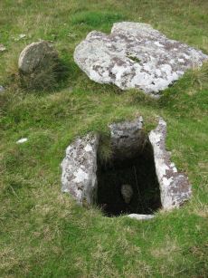
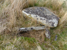
Swincombe Ford Newtake 1 Cist
OS Map: SX 63330 72988
HER record: MDV54431
Megalithic Portal: 42665
PMD: Swincombe Ford Newtake
ShortName: CT Swincombe 1
Butler map: 63.5.1
DPD page: 99
Notes: Butler Vol. 4. Map 63.5 (diagram p.215). "A robbed cist within a cairn on a gently sloping NE-facing moorland hillside. A stoney cairn 6.0m N-S by 5.5m E-W and 0.3m high contains the cist, approximately 0.8m wide, 0.3m deep and of indeterminate length and orientation. The capstone, 1.4m by 1.3m largely obscures the cist, with only the ?NE end stone being visible." Lethbridge diagram p.99 photo top of p.99.
Nearby sites: SX63337299
Swincombe Ford Newtake 1 (duplicate) Reported Cist
OS Map: SX 63450 72850
HER record: MDV59551
ShortName: CT:SwincombDup
Notes: Most likely a duplicate of HER 54431
Nearby sites: SX63457285
Swincombe Ford Newtake 2 Reported Cairn
OS Map: SX 63310 73070
HER record: MDV130278
ShortName: CN?Swincombe 2
Butler map: 63.5.2
Notes: Butler: "A short distance to the north is a smaller oval mound ... possibly a second burial cairn". Not listed on NMR or HER.
Nearby sites: SX63317307
Joan Ford's Newtake Stone Row
OS Map: SX 63183 71987
HER record: MDV6375
Megalithic Portal: 1985
The Stone Rows of GB: Joan Fords Newtake
PMD: Joan Ford's Newtake
Alternate name: Joan Ford's Newtake Stone Row
ShortName: SR Joan Fords
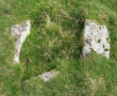
Notes: Stone Rows of Great Britain states: A probable single stone row measuring 7.27m long, including at least three large-sized upright orthostats and two recumbent slabs situated on a gentle south east facing slope. The stones stand up to between 1.55m and 1.23m high, arranged in height order with the tallest at the east. The row is orientated ENE to NSW and has restricted views of several skyline cairns and surrounding landscape. Breton (p.19) ... just above the river are 3 large monoliths in a row; do they form the end of a stone row, or are they part of a vanished linhay? Both the late Mr. Robert Burnard and Mr. R. Hansford Worth told me they did not know what they are, and neither do I. All we can say is the stones are there.
Nearby sites: SX63187199
Joan Ford's Newtake Embanked Cairn Circle and Cist
OS Map: SX 63143 72168
HER record: MDV6260
Megalithic Portal: 3295
PMD: Joan Ford's Newtake
Alternate name: Joan Ford's Newtake 1 Embanked Cairn Circle and Cist
ShortName: CT Joan Fords
Butler map: 63.3.1
DPD page: 99
Grinsell: LYD 92
Turner: B7
Barrow Report: 30 56
Notes: "A low kerb within the disturbed fringes of the mound is 8.7m in diameter with more or less continuous upright slabs and boulders 0.3m to 0.6m high. A dry stone newtake wall crosses the N side and overlies part of the kerb. A well-preserved cist, oriented NW-SE, is internally 1.0m long, 0.5m to 0.65m wide and up to 0.7m deep. The coverstone leans against the SE side of the cist and measures 1.35m by 1.0m by 0.2." Lethbridge diagram p.99, photo bottom p.99. Butler Joan Ford's Newtake 1 - Vol. 4. Map 63.3 (diagram p.214).
Nearby sites: SX63147217
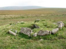
Joan Ford's Newtake Cairn Circle
OS Map: SX 62996 72282
HER record: MDV6261
Megalithic Portal: 3296
Alternate name: Joan Ford's Newtake 2 Cairn Circle
ShortName: CC Joan Fords
Butler map: 63.3.2
Grinsell: LYD 91
Turner: G22
Barrow Report: 30
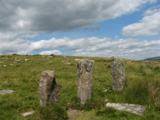
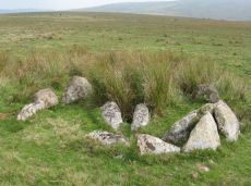
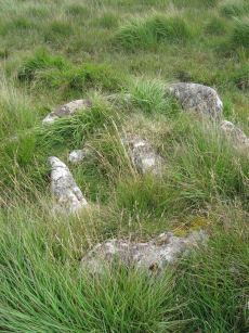
Notes: "A stone circle with six identifiable erect or leaning stones. One forms the E post of the gateway, the west post, 7ft high, stands outside the circumference. It is because of its small diameter, without doubt a retaining circle; any internal features such as a central hollow or possible kistvean have been obliterated by the wall builders." Turner Stone Circle G22. Bar Rep 30.
Nearby sites: SX63007228
Joan Ford's Newtake N.1 Cairn
OS Map: SX 62970 72264
HER record: MDV18389
Alternate name: Joan Ford's Newtake N.1 Cairn
ShortName: CN JoanFd N1
Butler map: 63.3
Nearby sites: SX62977226
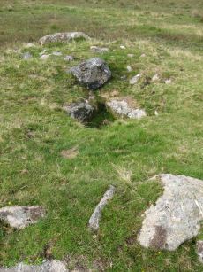
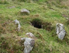
Joan Ford's Newtake N.2 Cairn Circle
OS Map: SX 63002 72332
HER record: MDV54460
Alternate name: Joan Ford's Newtake N.2 Cairn Circle
ShortName: CN JoanFd N2
Butler map: 63.3
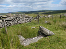
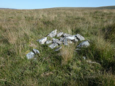
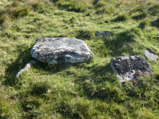
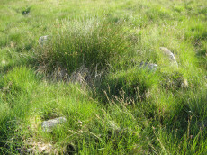
Notes: "A probable ring cairn situated on a slight NW slope. At least eight tin pits occur immediately to the E and S, and modern small stone clearance heaps are visible everywhere. The circular turf-covered stony bank is 12.2m in overall diameter, 2.0m wide and on average 0.4m high; a few stones protrude through the turf but there is no obvious trace of a kerb, slabs or boulders. Two or three modern clearance heaps lie on the bank and a gap on the N side with an adjacent corresponding pile of spoil is probably a recent mutilation" The photo shows one of the heaps on the bank which can just be seen.
Nearby sites: SX63007233
Tor Royal (newtake) Stone Ring Cairn Circle
OS Map: SX 62974 72262
HER record: MDV18388
Megalithic Portal: 45831
Alternate name: Joan Ford's Newtake N.3 Stone Ring Cairn Circle
ShortName: RC JoanFd N3
Butler map: 63.3
Turner: A18
Notes: "Disturbed ring cairn consisting of a stone ring 8.0 meters in diameter internally with bank 1.0 meter wide and 0.2 meters high." This feature was previously listed here at SX 62939 72246 but that is the location of the nearby cairn to the east of this ring cairn. This record has been updated with SX 62974 72262 from a visit on 04/09/23.
Nearby sites: SX62977226
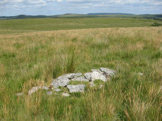
Joan Ford's Newtake N.4 Clearance Cairn
OS Map: SX 62911 72319
HER record: MDV18390
Alternate name: Joan Ford's Newtake N.4 Clearance Cairn
ShortName: CN JoanFd N4
Butler map: 63.3
Nearby sites: SX62917232
Joan Ford's Newtake N.5 Clearance Cairn
OS Map: SX 63050 72366
HER: No record found
Alternate name: Joan Ford's Newtake N.5 Clearance Cairn
ShortName: CN JoanFd N5
Notes: An oval shaped mound of stones that has the appearance of a modern clearance cairn. Added as record Joan Ford's Newtake N.5 to add to the Butler cairns N.1-N.4.
Nearby sites: SX63057237
Crock of Gold Ring Setting Cairn and Cist
OS Map: SX 61286 73076
HER record: MDV6308
Megalithic Portal: 14960
PMD: The Crock of Gold
ShortName: CT CrockofGold
Butler map: 65.2
DPD page: 101
Grinsell: LYD 86
Turner: D17
Barrow Report: 27 47 56
Notes: "The cairn, 7m in overall diameter and 0.3m high, has a flattish top with a retaining circle set 1m to 1.5m within the perimeter. This consists of six earthfast boulders, about 0.4m across and protruding a similar height above the cairn ... A central cist is oriented NW to SE. Internally it is 0.8m long, 0.4m wide at the NW end, 0.5m at the SE, and 0.7m deep. The side slabs are 1m long and respectively 0.15m and 0.25m thick; the end slabs, 0.5m long and 0.1m thick. The capstone, moved to the W, is 1.3m long, 1.1m wide and 0.15m thick and now rests against the kerb." Lethbridge diagram p.102 Cist(C), photo p.101. Butler Vol. 4. Map 65.2 (diagram p.229).
Nearby sites: SX61297308
Cholake Head Cairn
OS Map: SX 61460 73070
HER record: MDV6307
ShortName: CN:Cholake
Butler map: 65.2
Grinsell: LYD 87
Barrow Report: 27
Notes: HER: Turf-covered cairn lies on a broad slopping shelf on the E slopes of Royal Hill at 387m OD. Its diameter is approximately 5.2m by 4.9m and it has a maximum height of 0.5m a central pit is 2.5m across and 0.2m deep. Some stones and small orthostats protrude through the turf but there is no trace of a kerb or cist. Its relationship to a prehistoric wall (SX 67 SW 68), which extends from both the W and E sides of the cairn, is uncertain.
Nearby sites: SX61467307

Royal Hill Cairn
OS Map: SX 61817 71957
HER record: MDV6310
Megalithic Portal: 34957
Alternate name: Royal Hill E.1 Cairn
ShortName: CN:RoyalHill 1
Butler map: 65.5.1
Grinsell: LYD 93
Notes: "This impressive disturbed turf-covered cairn on the summit area of Royal Hill at 394m OD. It measures 16.4m (N-S) by 15.6m (E-W) with a maximum height of 1.8m. The flattish top has an off-centre pit 4.5m by 2.4m and 0.8m deep with some upcast material dumped around the top edge. Damage to the perimeter, reported in 1982 (8), has mostly been reinstated. The cairn is variously named Broken Barrow, Broken Barrows and Brokenborough"
Nearby sites: SX61827196
Royal Hill E.2 Reported Cairn
OS Map: SX 61790 71950
HER record: MDV130297
ShortName: CN?RoyalHill 2
Butler map: 65.5.2
Notes: Butler: A tiny satellite cairn inconspicuous some 30 m to the west has been exposed by turf cuters in the old ties across the summit. HER: Small Cairn '2' (Butler) on the summit of the south-eastern projection of Royal Hill
Nearby sites: SX61797195
Royal Hill, South Platform Cairn Circle and Cist
OS Map: SX 62020 72091
HER record: MDV6309
Megalithic Portal: 34958
PMD: Royal Hill SE.
Alternate name: Royal Hill E.3 Platform Cairn Circle and Cist
ShortName: CT RoyalHill 3
Butler map: 65.5.3
DPD page: 98
Grinsell: LYD 88
Turner: E31
Barrow Report: 27 47
Notes: "The cairn is 4.9m in diameter and 0.4m high with a flattish, platform, top. It is retained by a kerb of almost contiguous orthostats, the largest 1.1m long, 0.2m thick, and 0.6m high. A few are fallen or displaced. The central cist is oriented WNW to ESE, lacking both cover stone and N side slab. Internally it measures 1.35m by 0.75m by 0.55m deep." Lethbridge diagram p.97 Cist A, photo p.98. Butler Royal Hill E. 3 - Vol. 4. Map 65.5 (Cairn 3 - diagram p.233). Breton p.19.
Nearby sites: SX62027209
Royal Hill, Central Platform Cairn Circle and Cist
OS Map: SX 62082 72334
HER record: MDV6304
Megalithic Portal: 34960
PMD: Royal Hill E.
Alternate name: Royal Hill E.4 Platform Cairn Circle and Cist
ShortName: CT RoyalHill 4
Butler map: 65.5.4
DPD page: 98
Grinsell: LYD 89
Turner: E21
Barrow Report: 27 47
Notes: "The cairn has an overall diameter of about 7.5m in diameter, and 0.6m high, with a flattish top. There are traces of an inner kerb 4.5m in diameter, and an outer one 5.7m across comprising boulders and slabs, the largest 1.5m long, 0.6m high, and 0.2m thick. The interior of the central cist is about 0.8m square with four stones up to 0.25m thick and 0.6m deep but the southern one overlaps the sides, is 1m long, and gives the cist its NW to SE alignment. This and the two end stones incline inwards; the northern one inclines slightly outwards. There is no cover stone." Lethbridge diagram p.97 Cist B, photo p.98. Turner E21 - listed as Royal Hill (N) [n.b. we have a south, central & north - N being a different cist]. Butler Royal Hill E. 4 (Cairn 4 - diagram p.233) - Vol. 4. Map 65.5. Breton p.19.
Nearby sites: SX62087233
Royal Hill, North Ring Setting Cairn and Cist
OS Map: SX 62108 72434
HER record: MDV6305
Megalithic Portal: 34959
PMD: Royal Hill NE.
Alternate name: Royal Hill E.5 Ring Setting Cairn and Cist
ShortName: CT RoyalHill 5
Butler map: 65.5.5
DPD page: 98
Grinsell: LYD 90
Turner: D21
Barrow Report: 27 47
Notes: "The circle is 3.1m in overall diameter, comprising nine contiguous thick slabs, up to 0.9m long and from 0.3m to 0.7m high... There is virtually no cairn material but the interior has been levelled up to a height of 0.1m on the E, downhill side. A central cist oriented WNW to ESE is represented by two side stones which protrude 0.15m above ground. They are 1.2m and 0.9m long and both about 0.2m thick and 0.4m deep. The longer, northern one leans inwards and touches the other at the W end; at the E the stones are 0.8m apart separated by two flat (packing ?) stones each about 0.35m across. An overgrown and embedded slab against the circle W if the cist may have been an end stone." Lethbridge diagram p.97 Cist C, photo p.98. Butler Royal Hill E. 5 (Cairn 5 - diagram p.233)- Vol. 4. Map 65.5. Central cist. Breton p.19.
Nearby sites: SX62117243
Royal Hill E.6 Cairn
OS Map: SX 62080 72570
HER record: MDV28603
ShortName: CN:RoyalHill 6
Butler map: 65.5.6
Notes: HER: Turf-covered cairn is situated on a flat plain near the foot of the steep eastern slope of Royal Hill. It measures 5.7m in diameter, about 0.45m high and it has a central hollow approximately 1.5m in diameter and 0.3m deep in the top. On the northern side a few small ?upright stones, a maximum of 0.3m high, may mark the remnants of a kerb. There is no trace of a cist. Numerous small stone heaps, mostly dumped 19th century stone clearance material, are evident in the general vicinity
Nearby sites: SX62087257
Royal Hill Summit Cist
OS Map: SX 61295 72792
HER record: MDV18391
Megalithic Portal: 45798
PMD: Royal Hill Summit
ShortName: CT RoyalHill 7
Butler map: 65.5.7
Butler Vol 5: p.185 & Fig.128
DPD page: 102
Notes: Butler Royal Hill Summit Vol. 4. Map 65.2 (diagram Vol. 5. p.185). "The cairn 7.4m E to W, and 6.5m N to S, and about 0.5m high. It is turf covered, but the tops of three stones of an inner retaining circle are exposed to a height of 0.3m. The largest is 1.1m long and 0.2m thick ... The cist, oriented E to W is largely infilled; internally it measures 0.8m by 0.6m, and is 0.2m deep. The coverstone is missing as is the stone at the E end. The others take the form of irregular boulders rather than slabs". Lethbridge diagram p.102 Cist(D), photo p.102.
Nearby sites: SX61307279
Royal Hill E.8 Cairn
OS Map: SX 62270 71300
HER record: MDV78792
ShortName: CN?RoyalHill 8
Nearby sites: SX62277130
Royal Hill, wall Reported Cist
OS Map: SX 62640 72268
HER record: MDV18403
PMD: Swincombe
ShortName: CT-RoyalHill 9
Notes: The suggested cist, beside a length of bank and with numerous earthfast stones in visibility. The primary feature is a rectilinear slab 1.5 metres long, 1.2 metres wide and 0.1 metres thick. Its north-east corner rests upon a thin embedded stone, about 0.8 metres long and 0.1 metres high, and the slab is thus raised from the surface ... The impression gained is that, being similar to a coverstone, the large slab has been moved in the false expectation of a cist beneath.
Nearby sites: SX62647227
Royal Hill E. (c.8) Cairnfield Master
OS Map: SX 62650 72270
HER record: MDV18401
ShortName: CN:RoyalHill M
Notes: "Centred at SX62657227. Group of prehistoric cairns in a row running approx south-west to north-east.
Cairn A. The most northerly is crest-sited as you approach uphill from the south, with concave centre. Approximately 4.0 metres in diameter, Maximum height of 0.4 metres with a 2.0 metre length of wall attached to the south-west. Cairn B. The second cairn 33 metres to the south-west of A is 2.0 metres in diameter. Cairn C. 46 metres south-west of B is positioned against a natural boulder and measures 4.0 metres maximum diameter. Cairn D is located approximately 77 metres south-east of C. Oval, measuring 3.0 by 2.0 metres. Cairn E is 18 metres south-east of Cairn D and is 2.5 metres in diameter. Cairn F is 13 metres south-east of E and measures 3.0 metres in diameter."
"Centred SX 62597223. Eight scattered small turf-covered cairns lie on a SE hillslope at 360m OD on moorland pasture in an area cleared of surface stone except for large earthfast boulders. Mostly oval-shaped and rather ragged they are of compacted stones with some built against large earthfast boulders. There are no traces of formal construction.
The largest cairn, at SX 62607226, is 4.6m by 3.8m and 0.4m high with a disturbed centre and stone spill. The line of four cairns between SX 62597223 and SX 62587219 vary from 2.6m by 2.2m and 0.3m high to 3.5m in diameter and 0.5m high. The row of three cairns between.
SX 62647221 and SX 62677222 are from 2.5m by 2.0m and 0.3m high to 3.5m by 2.5m and 0.45m high.
They are almost certainly clearance cairns possibly of prehistoric origin as suggested by Greeves"
NB. SiteID=3021 MDV18403, reported cist with wall connected to it - this is very close to this group of 8 and could perhaps be one of them. However, the Probert & M. J. Fletcher (Report - Survey) SDV350839 tends to suggest it is a 9th separate feature.
Nearby sites: SX62657227
Royal Hill E. Cairn Cemetry A Clearance Cairn
OS Map: SX 62650 72270
HER record: MDV18401
ShortName: CN:RoyalHillA
Notes: "Cairn A. The most northerly is crest-sited as you approach uphill from the south, with concave centre. Approximately 4.0 metres in diameter, Maximum height of 0.4 metres with a 2.0 metre length of wall attached to the south-west." Part of cairn cemetry consisting of 8 reported 8 cairns, see master record SiteID 4068 (MDV18401)
Nearby sites: SX62657227
Royal Hill E. Cairn Cemetry B1 Clearance Cairn
OS Map: SX 62590 72230
HER record: MDV18401
ShortName: CN:RoyalHillB1
Notes: Cairn B. 1st of line of cairns B-B2-B3-C. Part of cairn cemetry consisting of 8 reported 8 cairns, see master record SiteID 4068 (MDV18401) "The second cairn 33 metres to the south-west of A is 2.0 metres in diameter."
Nearby sites: SX62597223
Royal Hill E. Cairn Cemetry B2 Clearance Cairn
OS Map: SX 62588 72218
HER record: MDV18401
ShortName: CN:RoyalHillB2
Notes: Cairn B2. 2nd of line of cairns B-B2-B3-C. Part of cairn cemetry consisting of 8 reported 8 cairns, see master record SiteID 4068 (MDV18401)
Nearby sites: SX62597222
Royal Hill E. Cairn Cemetry B3 Clearance Cairn
OS Map: SX 62584 72204
HER record: MDV18401
ShortName: CN:RoyalHillB3
Notes: Cairn B3. 3rd of line of cairns B-B2-B3-C. Part of cairn cemetry consisting of 8 reported 8 cairns, see master record SiteID 4068 (MDV18401)
Nearby sites: SX62587220
Royal Hill E. Cairn Cemetry C Clearance Cairn
OS Map: SX 62580 72190
HER record: MDV18401
ShortName: CN:RoyalHillC
Notes: Cairn C. 4th of line of cairns B-B2-B3-C. Part of cairn cemetry consisting of 8 reported 8 cairns, see master record SiteID 4068 (MDV18401)
Nearby sites: SX62587219
Royal Hill E. Cairn Cemetry D Clearance Cairn
OS Map: SX 62640 72210
HER record: MDV18401
ShortName: CN:RoyalHillD
Notes: Cairn D. 1st of line of cairns D-E-F. Part of cairn cemetry consisting of 8 reported 8 cairns, see master record SiteID 4068 (MDV18401)
Nearby sites: SX62647221
Royal Hill E. Cairn Cemetry E Clearance Cairn
OS Map: SX 62653 72215
HER record: MDV18401
ShortName: CN:RoyalHillE
Notes: Cairn E. 2nd of line of cairns D-E-F. Part of cairn cemetry consisting of 8 reported 8 cairns, see master record SiteID 4068 (MDV18401)
Nearby sites: SX62657222
Royal Hill E. Cairn Cemetry F Clearance Cairn
OS Map: SX 62670 72220
HER record: MDV18401
ShortName: CN:RoyalHillF
Notes: Cairn F. 3rd of line of cairns D-E-F. Part of cairn cemetry consisting of 8 reported 8 cairns, see master record SiteID 4068 (MDV18401)
Nearby sites: SX62677222
Goldsmiths Cross E.1. Cist
OS Map: SX 61871 70395
HER record: MDV61775
Megalithic Portal: 45806
PMD: Fox Tor Mires E.
Alternate name: Goldsmiths Cross E.1 Cist
ShortName: CT:GoldsmithE1
Butler map: 64.5.1
Notes: "Clear remains of cairn with cist. One side and one end stone of cist are in place. The western side stone may be beneath the turf, but the southern end stone and cover stone are missing. The internal dimensions of the cist are approximately 0.53 x 0.58 x 0.45 meters (1 foot 9 inches x 1 foot 11 inches x 1 foot 6 inches). Immediately around cist there was a backing of comparatively large flat stones.". Butler Goldsmith's Cross E. 1. Vol. 4. Map 64.5 (Cairn 1 - diagram p.221). There is no NMR for this site. There is an HER entry MDV61775 which matches precisely with the OS reference given by Butler. Butler describes: "The mound 0.1m high at best surrounds a slightly wedge-shaped cist of which only the sides, one composed of two stones, and an end are visible. The missing slab is probably buried in place".
Nearby sites: SX61877040
Goldsmith's Cross E.2. Ring Setting Cairn and Cist
OS Map: SX 61804 70321
HER record: MDV6342
Megalithic Portal: 42707
PMD: Fox Tor Mires cairn
Alternate name: Goldsmith's Cross E.2 Ring Setting Cairn and Cist
ShortName: CT GoldsmithE2
Butler map: 64.5.2
DPD page: 95
Grinsell: LYD 95
Turner: D23
Notes: "West end stone of cist leans slightly inwards, otherwise a perfect cist measuring 0.75m NW-SE by 0.5m wide by 0.4m deep. Retaining circle of 7 stones averaging 0.4m high. No coverstone or barrow". Lethbridge diagram p.93, photo bottom right p.95 and on p.96. Turner D23 (Fox Tor Mire) - Proc Devon Arch Soc 48 (diagram p.45). Butler Goldsmith's Cross E. 2 - Vol. 4. Map 64.5 (Cairn 2 - diagram p.221).
Nearby sites: SX61807032
Goldsmiths Cross E.3. Cist
OS Map: SX 61741 70204
HER record: MDV6343
Megalithic Portal: 45748
PMD: Goldsmith's Cross
Alternate name: Goldsmiths Cross E.3 Cist
ShortName: CT:GoldsmithE3
Butler map: 64.5.3
DPD page: 95
Grinsell: LYD 94
Barrow Report: 58
Notes: "The NW sidestone, 0.8m long by 0.2m wide and the NE endstone 0.6m long, 0.15m wide are the only recognisable cist stones though it is possible that the SW side was formed by the two small slabs still visible and depicted by Worth. There is no coverstone". Lethbridge diagram p.93, photo bottom left p.95. Butler Goldsmith's Cross E.3. - Vol. 4. Map 64.5 (Cairn 3 - diagram p.221).
Nearby sites: SX61747020
Goldsmith's Cross E.3 (duplicate) Reported Cairn
OS Map: SX 61709 70209
HER record: MDV12964
Alternate name: Goldsmith's Cross E.3 (duplicate) Reported Cairn
ShortName: CN:GoldsmithE4
Notes: Duplicate of 6343
Nearby sites: SX61717021
Fox Tor Newtake, North Cist
OS Map: SX 62861 71177
HER record: MDV6303
Megalithic Portal: 45677
PMD: Ter Hill N.
Alternate name: Ter Hill N.W.1 Cist
ShortName: CT FoxTorNew N
Butler map: 64.3.1
DPD page: 93
Grinsell: LYD 97
Barrow Report: 24 56
Notes: "The cist is 0.6m deep and 1.2m long, the NW end is 0.4m wide and SE end 0.6m wide; the NW end-slab, said by Burnard (1905)to be wedged in the bottom cannot be seen. The coverstone, resting on the NE side, is 1.6m by 1.3m at its extremeties". Lethbridge diagram (Cist A) and photo p.93. Butler Ter Hill N.W. 1 - Vol. 4. Map 64.3 (diagram p. 219).
Nearby sites: SX62867118
Fox Tor Newtake, South Cist
OS Map: SX 62864 70964
HER record: MDV6279
Megalithic Portal: 45678
PMD: Ter Hill S.
Alternate name: Ter Hill N.W.2 Cist
ShortName: CT FoxTorNew S
Butler map: 64.3.2
DPD page: 94
Grinsell: LYD 98
Barrow Report: 24 56
Notes: "The turf-covered cairn is, at maximum, 3.9m in diameter and 0.3m in height. The cist, oriented NW/SE, is approximately 1.3m by 0.55m, and 0.75m deep, and now almost hidden by the SW side stone which has fallen inwards. The NE end stone is not evident but an 0.7m high upright granite post retains part of the mound on this NE side. There is no trace of the coverstone". Lethbridge diagram p.93 (Cist B), top photos p.94. Butler Ter Hill N.W. 2 - Vol. 4. Map 64.3 (diagram p.219).
Nearby sites: SX62867096
Ter Hill N.W.3 Reported Cairn
OS Map: SX 62890 71090
HER record: MDV12969
ShortName: CN:Ter Hill 3
Grinsell: LYD 98a
Notes: A low turf-covered mound situated at SX 62887108 is probably the feature noted by both Fox and Grinsell. It lies in tall cotton grass on a south-west facing peat-covered hiislope in an area covered by low swellings, gullies and a marked accumulation of surface peat.
Nearby sites: SX62897109
Ter Hill N.W.4 Cairn
OS Map: SX 63820 70790
HER record: MDV58864
ShortName: CN:Ter Hill 4
Nearby sites: SX63827079
Fox Tor Mire Cairn
OS Map: SX 61800 70100
HER record: MDV12968
ShortName: CN:FoxTorMire
Grinsell: LYD 95a
Notes: On a gentle N slope is a peaty mound 3.5m in diameter and 0.3m high. On its W perimeter are two large earthfast stone 0.6m high. Several smaller ones protude through the peat near the centre indicating a stone content.
Nearby sites: SX61807010
Foxtor Mires W. Platform Cairn Circle and Cist
OS Map: SX 60780 70484
HER record: MDV12967
Megalithic Portal: 24008
PMD: Whiteworks
ShortName: CT FoxTorMireW
Butler map: 64.6
DPD page: 97
Turner: E19
Notes: "Seven large orthostats of the retaining circle remain in situ on the south and south-east side (see plan). The cist is entirely below ground level to a depth of 0.7m and measures 1.0m by 0.6m. The two endstones and two sidestones are visible; a stone which may be the coverstone lies on the ground to one side". Lethbridge diagram p.93, photos bottom p.97. Butler Foxtor Mires W. - Vol. 4. Map 64.6 (diagram p.222). Cairn with kerb circle, visible on N, E & W sides, with a central cist.
Nearby sites: SX60787048
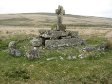
Childes Tomb Platform Cairn Circle and Cist
OS Map: SX 62577 70299
HER record: MDV48907
Megalithic Portal: 15211
PMD: Childe's Tomb
ShortName: CT ChildesTomb
Butler map: 64.4
DPD page: 94
Grinsell: LYD 96
Turner: E33
Notes: "A much disturbed cairn, 9m in diameter and 0.3m high with a modern 'kerb' of blocks and slabs, 5.8m in diameter and 0.5m high, set upon the mound. At the centre is a well built cist 1.4m long, 0.5m wide and 0.6m deep. Over this is a two tier pedestal of eight well trimmed blocks, of three different lengths; a further half buried block lies S of the monument. Upon this is a replacement socket stone and cross, cut at Holne in 1885". Lethbridge diagram p.93, photo p.94. Butler Vol. 4. Map 64.4 (diagram p.220). Breton p.22-23
Nearby sites: SX62587030
Weal Emma Leat (S) Reported Cairn
OS Map: SX 63880 71990
HER record: MDV12970
ShortName: CN?Weal Emma S
Grinsell: LYD 99
Notes: Hut circle
Nearby sites: SX63887199
Skir Hill (Henroost) Ring Setting Cairn and Cist
OS Map: SX 65104 70686
HER record: MDV6507
Megalithic Portal: 45676
PMD: Skir Hill
Alternate name: Skir Hill Ring Setting Cairn and Cist
ShortName: CT Skir Hill
Butler map: 61.8
DPD page: 92
Grinsell: LYD 102
Turner: D18
Barrow Report: 24 56
Notes: DM reports it is actually located at SX 65092 70684. The author has found this site at SX 65104 70691 on 28/06/18 assisted by the grid reference given by Dave Martin (DM). "A Bronze Age cairn containing a cist located on the north east facing slope of Skir Hill 590 metres south of Skir Ford. The cairn survives as a 4.1 diameter ring of edge set slabs up to 0.5 metres high. The cist is situated slightly west of the cairns centre and survives as a 0.82 metres long by 0.52 metres wide and 0.82 metres deep stone lined pit." Formerly listed as being at SX 6517 7075 (as per literature). Butler Vol. 4. Map 61.8 (diagram p.203).
Nearby sites: SX65107069
Page last updated 10/12/24