
Prehistoric sites within 5km of SX 67458 80970
Guidance for walkers: The monuments featured in this database are archaeological treasures and need to be protected and preserved - please do not disturb any sites. Please check access and firing times before visiting sites, not all sites listed are on open access land. Firing ranges and boundaries of open access areas are marked on the OL28 OS Dartmoor Explorer map. Please stick to the country code and consider giving support to the numerous agencies that help to keep Dartmoor a fabulous natural and historic environment!
About the database listings: In all listings clicking on the photo or the site name will open a page for the site with a larger photo and further details from the database. The database now has over 6680 records covering nearly all publicly listed sites on Dartmoor including around 4800 round houses. This level of detail is of interest to archaeologists but tends to swamp listings of sites more likely to be of interest for walkers. For this reason, the listings default to around 550 core sites only. These are the stone circles, stone rows and the ring cairns listed by Turner. The default search radius is 2 km. The controls below the map can be used to start a new search by entering a 6- or 8-digit reference (without the prefix "SX"). The search radius can be specified and you can add incremental Display layers of detail on top of the core sites. If using a more detailed layer you will need to decrease the search radius to avoid getting hundreds of search results.
- Core sites Default listing of core sites consisting of stone circles & rows and some of the major ring cairns.
- Plus cairns adds approx. 1000 cairns and other minor sites not included in the core listings but excluding round houses.
- Plus round houses adds approx. 4800 round houses.
- Plus non-sites adds in the records for sites that no longer exist or are not prehistoric sites.
- Plus duplicates adds records excluded as duplicates. Those maybe duplicate records in external listings (e.g. the Historic Environment Records). For example, some sites have been identified as cairns in some listings and interpreted as round houses in other listings and both records appear.
These listings have incorporated, matched up and merged all of the records from all of the major archaeological listings including: Worth, Grinsell, Turner, Butler, Bill Radcliffe, Sandy Gerrard, Megalithic Portal, the National Monument Records and the Historic Environment Records. The author would like to thank Bill, Sandy, the lovely people both at Megalithic Portal (especially Anne Tate who did an amazing job to link listings) and at ACE Archaeology for collaborative work over the years to synchronise and correct listings across the various websites which now interlink. A culmination of years of work the final merger of cairn records took 3 months of cross referencing in 2017 the result being a snapshot of the records at that time. This data has in turn been refined since by field work and research. The round house data was supplied by Sandy Gerrard. Grid references are in order of accuracy: from Google Earth satellite, if visible and found, from a Garmin GPS reading, if visited by the author and from the literature otherwise. Individual site pages will state the source of the grid reference and provide satellite imagery. If a site listing lacks a photo it has not yet been visited by the author in which case the grid reference is from the literature.
Currently the database only includes sites which can be represented by a grid reference. Reaves are not included as they require GIS shape technology which is beyond the current capability of this system. To see the sources for the records, look at the tables on the resources menu. The database listings can also be viewed on a Google map and downloaded as GPS datasets for Garmin devices.
Corrections, or any feedback or suggestions are very welcome, email: info@dartmoorwalks.org.uk.
NOTE: Clicking on the icons for each monument in the map will give the name of the site. You can zoom in and out and drag the map around.
List of sites within 5km of SX 67458 80970
Leapra Rings Enclosure
OS Map: SX 700 826
HER: MDV26675
ShortName: EN:Leapra
Notes: HER: Leapra Rings consists of three possibly Prehistoric circular features on Shapeley Common
Butler: Leapra Rings on steeply sloping ground on Shapley Common consist of three roughly circular banks levelled into the hillside. They are 10 - 12 metres in daimeter and over a metre high in places. About a third of the periphery is missing from the northern ring, perhaps not an original feature as neither of the orhters now has any visible entrance and their purposes is uncertain as they are too large for huts. A few slabs set edgeways show above the truf covered banks, occasionally paired and infilled with smaller stones in typically Prehistoric fashion.
Butler continues: Another enigmatic site lies in the second field to the north, on a good settlement site just above the damp ground surrounding the Leapra Brook. The overgrown remains are almost unrecognizable but appear to be of prehistoric construction like those above, perhpas a hut with a small paddock attached.
See also entries for round houses all of which are associated with the same HER entry: Shapley Tor N (SiteID=8275), Shapley Tor N (SiteID=8276) and Shapley Tor N (SiteID=8277)
Nearby sites: SX 700 826
Distance: 3.02km
Archerton Settlement
OS Map: SX 641 788
HER: MDV5931
Megalithic Portal: 42727
ShortName: ST:Archerton
Notes: An oval pound now planted with trees. Rowe noted remains of banks and a hut within the enclosure. Prowse mentions traceable sub-division banks with distinct evidence of nine hut circles and a further one, ten yards diameter, "close outside on the east". See: T.D.A. Vol. 23 pp.311-12
Nearby sites: SX 641 788
Distance: 4.00km
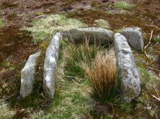
Archerton Tennis Ground Platform Cairn Circle and Cist
OS Map: SX 63852 78872
HER: MDV5839
Megalithic Portal: 37599
PMD: Archerton Tennis Court
Alternate name: Archerton Platform Cairn Circle and Cist
ShortName: CT Arch Tennis
Butler map: 27.18
DPD page: 114
Grinsell: LYD 45
Turner: E49
Barrow Report: 57
Notes: Lethbridge diagram p.112, photo top p.114. Butler Archerton - Vol. 2. Map 27.18. Breton p.37 Its four sides are complete, the capstone is partially buried; it stands on a slight mound and has been enclosed by a circle of small stones which are nearly buried under the turf.
Nearby sites: SX 63852 78872
Distance: 4.17km
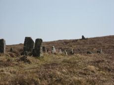
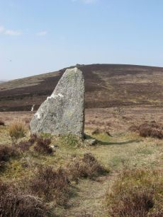
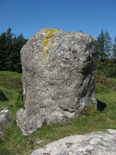
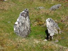
Assycombe Standing Stone
Prehistoric Dartmoor Walks: Dartmoor Site: Assycombe Double Stone Row
OS Map: SX 66101 82649
HER: MDV6537
Megalithic Portal: 1738
PMD: Assycombe Standing Stone
ShortName: SS Assycombe
Butler map: 35.19
DPD page: 135
Notes: Bronze Age stone row and cairn, Assycombe. The double stone row is 120m long terminating in the cairn at the North-East end. The South-West end is blocked by a stone 2.0m high. The largest stone, 2m high, lies at the E end and was re-erected re-erected by Baring-Gould in 1892 or 1893. The cairn is 8.4m in diameter and 0.6m high. Breton p.68.
Nearby sites: SX 66101 82649
Distance: 2.16km
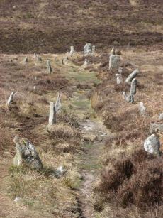
Assycombe Stone Row
Prehistoric Dartmoor Walks: Dartmoor Site: Assycombe Double Stone Row
OS Map: SX 66095 82641
HER: MDV6537
Megalithic Portal: 1738
The Stone Rows of GB: Assycombe Stone Row
PMD: Assycombe Stone Row
ShortName: SR Assycombe
Butler map: 35.19
DPD page: 135
Notes: "Bronze Age stone row and cairn, Assycombe. The double stone row is 120m long terminating in the cairn at the North-East end. The South-West end is blocked by a stone 2.0m high, re-erected there by Baring-Gould. The cairn is 8.4m in diameter and 0.6m high. Scheduled." Also from Burnard's 1892 field notes: The row, which starts from a ruined cairn, consists of 84 standing stones, and extends 800 feet E. and W., running in two rows down the hill towards Assycombe. It terminates towards the W. in a stone lying prone, 5' 9" long. 2'' wide. The avenue is from 5' to 6' wide, inner measurement. The stones composing the row are 18" high, and down to 6". Breton p.67-68.
Nearby sites: SX 66095 82641
Distance: 2.16km
Assycombe Hill Encircled Cairn and Cist
Prehistoric Dartmoor Walks: Dartmoor Site: Assycombe Double Stone Row
OS Map: SX 66102 82650
HER: MDV6538
Megalithic Portal: 45814
PMD: Assycombe Stone Row
Alternate name: Assycombe Hill Stone Row Encircled Cairn and Cist
ShortName: CT Assycombe
Butler map: 35.19
Butler Vol 5: p.232 & Fig.164
DPD page: 135
Grinsell: LYD 26
Turner: F16
Notes: The cairn at the E end is in line with the N of the two rows. It measures 8.4m in diameter and is 0.6m high. It contains a large quantity of stone; two stones in the centre, set at right angles to each other around a hollow, suggest the remains of a cist. Breton p.68.
Nearby sites: SX 66102 82650
Distance: 2.16km
Berry Pound
OS Map: SX 71325 80349
HER: MDV8754
ShortName: PD:Berry
Notes: Berry Pound a Prehistoric enclosure on Hamel Down
Nearby sites: SX 71325 80349
Distance: 3.92km
Birch Tor Ancient Pool
OS Map: SX 68686 81656
HER: MDV127183
ShortName: PO:Birch Tor
Notes: "The pool at Birch Tor measures around 15.5m. One of over 40 such 'sacred' pools identified on Dartmoor that are thought to have potentially been designed during the prehistoric period."
Nearby sites: SX 68686 81656
Distance: 1.41km
Birch Tor Cairn
OS Map: SX 68686 81654
HER: MDV6673
Megalithic Portal: 34981
Alternate name: Birch Tor Summit Cairn
ShortName: CN:Birch Tor
Butler map: 24.4
Grinsell: N.BOV 1
Barrow Report: 56
Notes: "The heavily disturbed remains of a large, flat-topped cairn lie on the ridge crest 230 metres north of Birch Tor. The centre and south margin of this feature have apparently suffered from an unrecorded excavation with spoil dumped to the south and on the east fringe of the mound. Two large upright slabs are embedded in the unexcavated interior of the cairn and may have previously been interpreted as elements of a kerb even though they lie several metres in from the actual edge of the feature. 10m to the north-west of the cairn is a warren boundary stone inscribed with the letters`WB'on its eastern side."
Nearby sites: SX 68686 81654
Distance: 1.41km
Blackaton Down N. Cairn
OS Map: SX 70683 79094
HER: MDV7413
Megalithic Portal: 16633
ShortName: CN Blackaton N
Butler map: 20.12.1
Butler Vol 5: p.193 & Fig.137
Grinsell: WID 4
Notes: The earthwork remains of two Bronze Age cairns. 'B' is a cairn 42 feet in diameter and 3 feet high. Cairn with small hollow towards centre. Butler Volume 1 Map 20.12.
Nearby sites: SX 70683 79094
Distance: 3.73km
Blackaton Down S. Cairn
OS Map: SX 70732 79047
HER: MDV7412
Megalithic Portal: 16634
ShortName: CN:Blackaton S
Butler map: 20.12.2
Butler Vol 5: p.192 & Fig.136
Grinsell: WID 5
Notes: ['A' SX 7073 7904]. Tumuli on saddle, 'A' is 40 feet in diameter with a rim 1 ft. high. One of pair of cairns, this one is concave or "saucer" shaped. Butler Volume 1 Map 20.12.
Nearby sites: SX 70732 79047
Distance: 3.80km
Blackaton Newtake (Hameldown) Ancient Pool
OS Map: SX 70785 78973
HER: MDV7527
ShortName: PO:Hameldown
Notes: Previously recorded as a possible cairn (was listed here as Hameldown 2 Reported Cairn), although identification noted later as 'doubtful' - water filled depression with a few surface stones. Identified as one of the 40+ 'sacred pool' sites on the moor, possibly dating from the Prehistoric period.
Nearby sites: SX 70785 78973
Distance: 3.88km

Broad Barrow Stone Ring Cairn Circle
OS Map: SX 70577 79908
HER: MDV20787
Megalithic Portal: 16630
Alternate name: Broad Burrow Stone Ring Cairn Circle
ShortName: RC BroadBarrow
Butler map: 20.9
Butler Vol 5: p.166 & Fig.106
Grinsell: MAN 10
Turner: A46
Notes: "Infilled ring cairn. Stone ring 14 metres diameter internally with bank 2.5 metres wide and 0.4 metres high. Infilled to 0.25 metres below bank top." Butler Volume 1 Map 20.9.
Nearby sites: SX 70577 79908
Distance: 3.29km
Broadun Enclosed Settlement
OS Map: SX 6354 7993
HER: MDV5946
Megalithic Portal: 26043
ShortName: ES:Broadun
Notes: "An enclosed settlement, maximum dimensions 300m NE/SW by 250m NW/SE, giving an area of 6ha. Enclosure cut through on SE by a leat, but wall still visible. Inside are 36 huts, and a further 3 outside. Condition of huts mainly poor. Average internal diameter is 3.7m: the largest is 13m by 10.5m, the smallest 2.5m. The enclosure wall appears contemporary with or later than the huts. The interior of the enclosure appears to have been cleared." See also HER entry 6800
Nearby sites: SX 6354 7993
Distance: 4.05km
Broadun Ring Enclosed Settlement
OS Map: SX 63704 80192
HER: MDV6746
Megalithic Portal: 26048
ShortName: ES BroadunRing
Notes: Breton p.38
Nearby sites: SX 63704 80192
Distance: 3.83km
Bush Down Settlement
OS Map: SX 6849 8217
HER: MDV6596
Megalithic Portal: 7699
ShortName: ST:BushDown
Nearby sites: SX 6849 8217
Distance: 1.58km
Cator Pound
Prehistoric Dartmoor Walks: Dartmoor Site: Cator Pound
OS Map: SX 6730 7765
HER: MDV6009
Megalithic Portal: 34961
ShortName: PD Cator Pound
Notes: HER: Cator pound, widecombe. In his survey of widecombe made about 1750, dean milles describes 'a very considerable circle of stones on the n part of the western down on a farm called cator and on an eminence called whitehill'; he gives the diameter as 58 paces and says it consisted 'chiefly of large stones mowst of which rise about 4 feet above ye ground. This circle consists now of about 30 stones but there are spaces where several more stood, half the number are fallen; the rest are either erect or on their sides'.
Nearby sites: SX 6730 7765
Distance: 3.32km
Cator Common Embanked Cairn Circle
Prehistoric Dartmoor Walks: Dartmoor Site: Cator Pound
OS Map: SX 67426 78001
HER: MDV5978
Megalithic Portal: 52173
ShortName: CC CatorCommon
Butler map: 18.4
Grinsell: WID 1
Turner: B3
Notes: HER: Cairn, hollow towards centre. Retaining circle of c.28 upright slabs, mostly turned inwards. Diameter 18.0m, height 0.6m. Breton p.41
Nearby sites: SX 67426 78001
Distance: 2.97km

Cator Common Platform Cairn Circle and Cist
OS Map: SX 67118 77510
HER: MDV5987
Megalithic Portal: 45793
PMD: Pizwell Bridge
Alternate name: Pizwell Bridge Platform Cairn Circle and Cist
ShortName: CT Pizwell 1
Butler map: 18.5
Butler Vol 5: p.171 & Fig.110
Grinsell: WID 2
Turner: E10
Notes: "Pizwell Bridge cairn of circa 5m diameter by 0.5m high is to be found about 10m below the road in an unusual position near the base of the hill. Three retaining slabs form an arc around one side with another just under the turf. The top of a slab near the centre with a pit alongside might be one side of a cist. ". Butler Pizwell Bridge Vol. 1. Map 18.5 (diagram Vol 5. p.171). Possible central cist.
This feature can be seen from the road in the distance by a small tree but it is not on public access land and the area has a high fence surrounding it. The photo above was taken by Steve Szykpo and is reproduced with his kind permission.
Nearby sites: SX 67118 77510
Distance: 3.48km
Challacombe Down Cairn Circle
Prehistoric Dartmoor Walks: Dartmoor Site: Challacombe Down Triple Stone Row
OS Map: SX 6898 8084
HER: MDV49462
Megalithic Portal: 1819
PMD: Challacombe Down Stone Row
ShortName: CC Challacombe
Butler map: 24.3
Butler Vol 5: p.239 & Fig.169
Turner: G20
Notes: Dubious site - the current arrangement relates to stones placed during restoration of the stone row. See Worth (1953) p. 226 on how "nothing coherent" came of attempts to re-erect stones scattered to the west of the north end of the row which gave the appearance of a stone circle.
Nearby sites: SX 6898 8084
Distance: 1.53km
Challacombe Down Standing Stone
Prehistoric Dartmoor Walks: Dartmoor Site: Challacombe Down Triple Stone Row
OS Map: SX 69021 80723
HER: MDV6600
Megalithic Portal: 10092
PMD: Challacombe Stone Row
ShortName: SS Challacombe
Butler map: 24.3
DPD page: 126
Notes: The largest and most prominent blocking stone of the Dartmoor rows is to be found at the Challacombe triple row. Worth states that it is over 5 feet in width at the base and over 6 feet in height. Butler (Vol. 2) states that the terminal pillar is today 0.5m shorter than when it was measured in 1893.
Nearby sites: SX 69021 80723
Distance: 1.58km
Challacombe Down Stone Row
Prehistoric Dartmoor Walks: Dartmoor Site: Challacombe Down Triple Stone Row
OS Map: SX 69016 80718
HER: MDV6600
Megalithic Portal: 1819
The Stone Rows of GB: Challacombe Down
PMD: Challacombe Stone Row
ShortName: SR Challacombe
Butler map: 24.3
Butler Vol 5: p.239 & Fig.169
DPD page: 126
Notes: "Bronze Age triple stone row well marked and wider apart at the north, drawing nearer to the south where they meet a blocking stone of unusual size. The stones have suffered little in their restoration except that a stone in the middle row was turned to form a blocking stone for that row. The loose stones scattered to the west of the north end have been suggested to form a stone circle and additional rows but may be stones excavated from the north end of the stone row." Breton p.41-42
Nearby sites: SX 69016 80718
Distance: 1.58km
Chittaford Down Platform Cairn Circle
OS Map: SX 63502 79203
HER: MDV5832
Megalithic Portal: 42726
PMD: Archerton
Alternate name: Chittaford Down 1 Platform Cairn Circle
ShortName: PC Chittaford1
Butler map: 27.18.1
Butler Vol 5: p.170 & Fig.109
Grinsell: LYD 38
Turner: E14
Notes: "Remains of a cairn, visible as a turf covered stony mound. The NE quadrant is robbed out but around the rest of the periphery are parts of a kerb of small boulders, some set on edge, giving a diameter of 6.5m NW-SE. Maximum height 0.6m in the SW quadrant, but elsewhere the interior is badly robbed." Butler says there is a possible end slab of a cist.
Nearby sites: SX 63502 79203
Distance: 4.33km
Chittaford Down Platform Cairn Circle and Cist
OS Map: SX 63687 79463
HER: MDV5932
Megalithic Portal: 52177
PMD: Chittaford Down
Alternate name: Chittaford Down 3 Platform Cairn Circle and Cist
ShortName: CT Chittaford3
Butler map: 27.18.3
Butler Vol 5: p.160 & Fig.100
DPD page: 112
Grinsell: LYD 39
Turner: E28
Barrow Report: 57
Notes: "A cist about 350 yards north of Archerton House. It has an irregular shape no coverstone and stands in the centre of a 14ft. diameter ruined cairn. There are traces of an enclosing ring of stones. Excavation in 1900 recovered wood charcoal and a worked flint flake from a small pit within the cist. Under the eastern side stone an archer's polished stone wrist guard was found". Lethbridge diagram and photo bottom p.112. Butler Chittaford Down 3 - Vol. 2. Map 27.18 (diagram Vol. 5. p.160).
Nearby sites: SX 63687 79463
Distance: 4.06km
East Lowton Settlement
OS Map: SX 666 837
HER: MDV107002
Megalithic Portal: 34966
ShortName: ST:EastLowton
Nearby sites: SX 666 837
Distance: 2.86km
Fernworthy Stone Circle
Prehistoric Dartmoor Walks: Dartmoor Site: Fernworthy Ceremonial Complex
OS Map: SX 65486 84126
HER: MDV6534
Megalithic Portal: 530
PMD: Fernworthy Stone Circle
ShortName: SC Fernworthy
DPD page: 138
Turner: G13
Notes: The Fernworthy circle is part of a group of ceremonial monuments including 3 stone rows and 5 cairns that may once have rivalled Merrivale and Shovel Down as ceremonial centres. The site is in a small clearing in Fernworthy Forrest off the path to Teignhead Farm. The circle is remarkably intact with all but 2 stones still in their original places ... It is 20m in diameter and consists of 27 small stones. The stone rows and cairns probably came later and surround the site. The circle was excavated by the Dartmoor Exploration Committee in 1897. They found that the interior of the circle was covered in a layer of charcoal suggesting that it had been the scene of very many fires - perhaps funeral pyres or feasts. See also Legendary Dartmoor: Dartmoor's Fernworthy Stone. DNP Post 3D. Breton p.66-67
Nearby sites: SX 65486 84126
Distance: 3.72km
Fernworthy Ceremonial Complex
Prehistoric Dartmoor Walks: Dartmoor Site: Fernworthy Ceremonial Complex
OS Map: SX 6548 8412
HER: MDV6534
Megalithic Portal: 35937
PMD: Fernworthy
ShortName: CX Fernworthy
DPD page: 138
Notes: Lethbridge p.138. Breton p.66-67.
Nearby sites: SX 6548 8412
Distance: 3.72km
Fernworthy Settlement
OS Map: SX 648 837
HER: MDV6731
Megalithic Portal: 10485
ShortName: ST:Fernworthy
Nearby sites: SX 648 837
Distance: 3.81km

Fernworthy Cist
Prehistoric Dartmoor Walks: Dartmoor Site: Fernworthy Ceremonial Complex
OS Map: SX 65491 84100
HER: MDV6719
Megalithic Portal: 35826
PMD: Fernworthy
Alternate name: Fernworthy 2 Cist
ShortName: CT Fernworth 2
Butler map: 35.15.2
Butler Vol 5: p.36 & Fig.13
DPD page: 138
Grinsell: LYD 23
Notes: The remains of this cist are in the 6m diameter barrow at the N end of the Fernworthy S.E. stone row. The cist in the centre is represented by two stones set at right angles, 0.4m tall internally. Excavated by the Dartmoor Excavation Committee in 1898. A lot of burnt bone was found. DNP Post 6D. Butler Vol. 2. Map 35.15.2 (diagram Vol. 5. p.36 - row 2). Newman Barrow B.
Nearby sites: SX 65491 84100
Distance: 3.70km
Fernworthy (SW) Encircled Cairn
Prehistoric Dartmoor Walks: Dartmoor Site: Fernworthy Ceremonial Complex
OS Map: SX 65483 84101
HER: MDV14885
Megalithic Portal: 35827
Alternate name: Fernworthy 3 Encircled Cairn
ShortName: EC Fernworth 3
Butler map: 35.15.3
Butler Vol 5: p.36 & Fig.14
Grinsell: LYD 21
Turner: F25
Notes: Newman Barrow A. Small turf-covered cairn at the northern end of the western double stone row south of Fernworthy stone circle forming part of the Froggymead ceremonial complex. It measures 6.5 metres in diameter and has a central hollow resulting from excavation in 1898. Two rings of orthostats, 7m and 5m diameter, around cairn 4.5m diameter and 0.2m high (Turner). It once had a retaining circle of small stones but only three were visible in 2013. DNP Post 2D. Turner F25.
Nearby sites: SX 65483 84101
Distance: 3.70km

Fernworthy Barrow C Cairn
OS Map: SX 65485 84047
HER: MDV14887
Megalithic Portal: 35829
Alternate name: Fernworthy 4 Cairn
ShortName: CN:Fernworth 4
Butler map: 35.15.4
Grinsell: LYD 22
Notes: Newman Barrow C.Cairn forming part of the cermonial complex at Froggymeade. Sitated at the southern end of the eastern stone row to the south of Fernworthy stone circle. It was excavated in 1898 but had previously been disturbed. Only one small flint flake was found.
Nearby sites: SX 65485 84047
Distance: 3.66km

Fernworthy E. Encircled Cairn
Prehistoric Dartmoor Walks: Dartmoor Site: Fernworthy Ceremonial Complex
OS Map: SX 65561 84090
HER: MDV6560
Megalithic Portal: 3234
Alternate name: Fernworthy 5 Encircled Cairn
ShortName: EC:Fernworth 5
Butler map: 35.15.5
DPD page: 138
Grinsell: LYD 24
Turner: F4
Notes: Newman Barrow D. "5.8m diameter. Has 3 stones spaced on the east side. A beaker, flint knife, dress fastener and a piece of bronze were discovered when the cairn was excavated in 1898". The crushed beaker. When reconstructed it became one of Dartmoor's most important Bronze Age finds and is now on display in Plymouth City Museum along with the other artifacts retrieved. DNP Post 7D.
Nearby sites: SX 65561 84090
Distance: 3.65km
Fernworthy N. Cairn
OS Map: SX 65539 84333
HER: MDV6563
Megalithic Portal: 35828
The Stone Rows of GB: Fernworthy 1
PMD: Fernworthy N Row
Alternate name: Fernworthy 1 Cairn
ShortName: CN Fernworth 1
Butler map: 35.15.1
Grinsell: LYD 20
Notes: Newman Barrow E. Remains of a small cairn at the northern terminus of the double stone row north of the Fernworthy stone circle. The cairn has been damaged by past tree planting and the feature can be hard to identify as the remains are low to the ground and spread far beyond its original form. Radcliffe quotes Butler and also refers to HER/SMR number 6556 or 6562. "The 1898 plan shows a mound with a stone alongside as its northern terminus, probably a cairn, 1, with a retaining circle. This stone is still visible together with another at an angle, perhaps one side of a cist ..." (Butler Vol 2 pp. 164-5)
Nearby sites: SX 65539 84333
Distance: 3.87km
Fernworthy N. Stone Row
Prehistoric Dartmoor Walks: Dartmoor Site: Fernworthy Ceremonial Complex
OS Map: SX 65538 84336
HER: MDV6562
Megalithic Portal: 1933
The Stone Rows of GB: Fernworthy 1
PMD: Fernworthy B Stone Row
Alternate name: Fernworthy 1 Stone Row
ShortName: SR Fernwthy N
Butler map: 35.15.1
DPD page: 138
Notes: Butler Row 1. "To the N of Fernworthy stone circle is a double stone row. At its N end are the disturbed remains of a barrow. The row survives well for 125m although beyond this (to the N) it has been heavily disturbed by forestry activity as far as the barrow. The plan of 1898, made prior to afforestation, shows the N end of the double row as already `buried or lost'. The surviving part of the double row contains paired, low stones 0.8m to 1.4m apart, averaging 0.3m high, although many are flush with the ground. The tallest stones are at the S end. The alignment of the row is tangential to the circle (SX 68 SE 56). The barrow at the N end of the row measures 6m in diameter, although it is very amorphous due to tree planting. there is a large proportion of stone in the centre of the low mound, as well as some amorphous scarping and one large upright slab." DNP Post 8D. Breton p.67.
Nearby sites: SX 65538 84336
Distance: 3.88km
Fernworthy S.E. Stone Row
Prehistoric Dartmoor Walks: Dartmoor Site: Fernworthy Ceremonial Complex
OS Map: SX 6549 8407
HER: MDV6556
Megalithic Portal: 10484
The Stone Rows of GB: Fernworthy 2
PMD: Fernworthy C Stone Row
Alternate name: Fernworthy 2 Stone Row
ShortName: SR Fernwthy SE
Butler map: 35.15.2
DPD page: 138
Notes: Butler Row 2. "Centred at SX 65518404 is a cairn. 45m to the N at SX 65508409 is a barrow containing the remains of a cist. Between the two are the very fragmented remains of an alleged double stone row running N to S parallel to another row (SX 68 SE 59) which leads towards Fernworthy Stone Circle. The row, barrow and cairn have all been comprehensively damaged by afforestation and the digging of the adjacent drainage channels. Seven stones survive of an alignment but there is little evidence that it was a double row. The barrow at the N end of the row measures up to 6m in diameter and is 0.4m high, although its shape is obscured by drainage channels. The cist in the centre is represented by two stones set at right angles, 0.4m tall internally. The cairn at the S end of the row measures 7.3m N to S by 8.5m and is 0.5m high. There is a large amount of surface stone on and around it." DNP Post 5D.
Nearby sites: SX 6549 8407
Distance: 3.67km
Fernworthy S.W. Stone Row
Prehistoric Dartmoor Walks: Dartmoor Site: Fernworthy Ceremonial Complex
OS Map: SX 65479 84105
HER: MDV14886
Megalithic Portal: 1934
The Stone Rows of GB: Fernworthy 3
PMD: Fernworthy A Stone Row
Alternate name: Fernworthy 3 Stone Row
ShortName: SR Fernwthy SW
Butler map: 35.15.3
DPD page: 138
Notes: Butler Row 3. "A disturbed double stone row is centred SX 65488408. It is 21m long and is oriented N to S. At the N end is a cairn (SX 68 SE 58) offset slightly W of the alignment of the row. Beyond this to the N is Fernworthy Stone Circle (SX 68 SE 56). The S end of the row is not very well preserved. The plan of 1898 depicts it terminating at a stone in the face of a wall, although the wall has since been removed. The stones in the row average 0.5m to 0.6m tall and lie in an area of amorphous modern earthworks up to 0.3m deep." DNP Post 1D. Breton p.67.
Nearby sites: SX 65479 84105
Distance: 3.71km
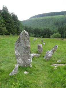
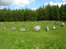
Grey Wethers (N) Stone Circle
Prehistoric Dartmoor Walks: Dartmoor Site: Grey Wethers Double Stone Circle
OS Map: SX 63875 83161
HER: MDV6758
Megalithic Portal: 532
PMD: Grey Wethers Stone Circles
ShortName: SC Grey Weth N
DPD page: 134
Turner: G4
Notes: "Northern stone circle of the pair known collectively as The Grey Wethers. This circle measures 31.5 metres in diameter and is denoted by 20 upright granite slabs with an average height of 1.1 metres. Excavations carried out by the Dartmoor Exploration Committee towards the end of the 19th century revealed a layer of charcoal covering the original ground surface. A shallow trench visible leading through the southern circle may be the result of this excavation. The circle was restored at this time". Grinsell [Folklore 1976]: The stones turn round at sunrise. King 1873, 780; St Leger Gordon 1972, 71-2.
Nearby sites: SX 63875 83161
Distance: 4.20km
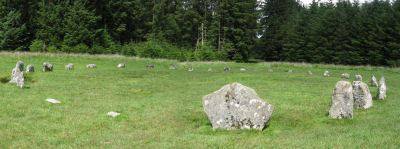
Grey Wethers (S) Stone Circle
Prehistoric Dartmoor Walks: Dartmoor Site: Grey Wethers Double Stone Circle
OS Map: SX 63874 83121
HER: MDV6759
Megalithic Portal: 532
PMD: Grey Wethers Stone Circles
ShortName: SC Grey Weth S
DPD page: 134
Turner: G2
Notes: This site is one of the most impressive on Dartmoor. The circles were restored in 1909 by Burnard. At the time only 9 stones remained standing in the north circle and 7 in the south circle. It is thought that the reconstruction is fairly accurate. The circles are separated by a few meters and are almost identical. Both circles have 30 stones and diameters very close to 33 m and they are within 2 degrees of being on an exact north to south alignment. The slight differences between the two circles could even be a result of the restoration. Apparently "wether" is an old English name for sheep and legend has it that a drunken farmer leaving the Warren House Inn was persuaded that the Grey Wethers were a desirable flock for sale! See also, Legendary Dartmoor: Grey Wethers. Grinsell [Folklore 1976]: The stones turn round at sunrise. King 1873, 780; St Leger Gordon 1972, 71-2.
Nearby sites: SX 63874 83121
Distance: 4.18km
Grimslake Platform Cairn Circle and Cist
OS Map: SX 70414 81166
HER: MDV8744
Megalithic Portal: 44533
The Stone Rows of GB: Grimslake Cist
PMD: Hookney Down
Alternate name: Grimslake Mire Platform Cairn Circle and Cist
ShortName: CT Grimslake
Butler map: 20.16
Butler Vol 5: p.219 & Fig.153
DPD page: 128
Grinsell: N.BOV 3
Turner: E18
Notes: Cairn with kerb circle and central cist. Lethbridge diagram p.127 and photo top p.128. Butler Grimslake Mire - Vol. 1. Map 20.16 (diagram p.147).
Nearby sites: SX 70414 81166
Distance: 2.96km
Grimspound Enclosed Settlement
Prehistoric Dartmoor Walks: Dartmoor Site: Grimspound Enclosed Settlement
OS Map: SX 70073 80909
HER: MDV8778
Megalithic Portal: 1344141065
ShortName: ES Grimspound
DPD page: 127
Notes: Probabaly the best known enclosed settlement on Dartmoor, within walking distance of Warren House Inn. "Prehistoric enclosed settlement with a substantial granite surrounding wall, containing 24 hut circles, as well as several 'pens' built into the enclosure wall, positioned in a valley between Hookney Tor and Hameldon. First planned by A. C. Shillibeer in 1829, this site was excavated by the Dartmoor Exploration Committee in 1894-5. Within the guardianship area managed by Dartmoor National Park Authority". Extensive notes on the HER record, see also coverage on Wikipedia and Legendary Dartmoor.
Nearby sites: SX 70073 80909
Distance: 2.62km
Hameldon Cist
OS Map: SX 71008 78345
HER: MDV7519
Megalithic Portal: 16636
PMD: Hamel Down S.
Alternate name: Hamel Down S. Cist
ShortName: CT Hameldon
Butler map: 20.15
Butler Vol 5: p.178 & Fig.120
DPD page: 129
Grinsell: WID 7
Barrow Report: 54
Notes: Precise location originally unsurveyed but given approximately by Worth as SX 71257908. This may explain the large discrepancy between the NMR position and that given by Butler and in the HER. Three sides of the cist are visible with the fourth having sunken below the earth. The capstone is incomplete and only partly covers the cavity. Lethbridge diagram p129 and photo top p.129. Butler Hamel Down 15 (S) - Vol. 1. Map 20.15 (Cairn 15 p.149, diagram Vol 5. p.178).
Nearby sites: SX 71008 78345
Distance: 4.42km
Hameldown Beacon Cairn
OS Map: SX 70830 78922
HER: MDV7435
Megalithic Portal: 16635
Alternate name: Hamel Down Beacon Cairn
ShortName: CN HamelBeacon
Butler map: 20.13
Butler Vol 5: p.166 & Fig.106
Grinsell: WID 6
Notes: A grass covered cairn which was alleged to have been used as a beacon in medieval period. Butler Volume 1 Map 20.13
Nearby sites: SX 70830 78922
Distance: 3.95km
Hameldown N.E. Stone Row
OS Map: SX 71481 80095
HER: MDV18865
Megalithic Portal: 6333472
The Stone Rows of GB: Hameldown
PMD: Berry Pound Stone Row
Alternate name: Hamel Down Stone Row
ShortName: SR Hamel NE
Butler map: 20.3
Notes: No NMR listing. HER record MDV18865. Described in Butler Volume 1 Map 20.3. To the south of Berry Pound is a small longhouse. "Within the abandoned field 250m south of the longhouse are the probable remains of a single row first recorded in 1983. Five or six stones remain in line up to 206m apart, the rest having been removed or buried when the field was ploughed."
Nearby sites: SX 71481 80095
Distance: 4.12km
Hameldown Tor Cairn
OS Map: SX 70318 80574
HER: MDV8768
Megalithic Portal: 16628
ShortName: CN HameldonTor
Butler map: 20.8
Butler Vol 5: p.166 & Fig.106
Grinsell: MAN 2
Turner: E54
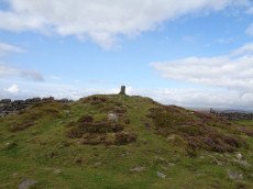
Notes: Cairn on hameldown tor.(diam 14m. Heig 700mm)a denuded cairn with kerb of large stones on northern half only. Pillar and conical mound of small stones of evidently modern date. Remainder of kerb visible (11 stones). Remainder of cairn largely grassed over but head sized granite boulders visible (os trig. Point and recent mound of stones on top). Butler Volume 1 Map 20.8.
Nearby sites: SX 70318 80574
Distance: 2.89km
Heath Stone Standing Stone
Prehistoric Dartmoor Walks: Dartmoor Site: Hurston Ridge Double Stone Row
OS Map: SX 67133 83755
HER: MDV6650
Megalithic Portal: 14933
ShortName: SS Heath Stone
Butler map: 25.
Notes: The original Heath Stone was a boundary stone which was referred to in the Perambulation of the Forest of Dartmoor in 1240 and some very early maps. According to Butler (Vol. 2 Map 25 p.32) the stone carved with a biblical inscription in 1970 that is currently known as the Heath Stone is unlikely to have been the original Heath Stone as it is in a useless position to be of any use as a boundary stone. The stone was not included in maps from the 18th century and then reappeared in a different location. It is doubtful that the current stone is the original or that it is prehistoric. Crossing suggests that the large standing stone in the Hurston Ridge stone row is the actual Heath Stone. See also, Legendary Dartmoor: The Dartmoor Heathstone
Nearby sites: SX 67133 83755
Distance: 2.80km
Hemstone Rocks Platform Cairn Circle
OS Map: SX 64856 83806
HER: MDV6730
Megalithic Portal: 45619
PMD: Hemstone Rocks
Alternate name: Hemstone Rocks N.3 Platform Cairn Circle
ShortName: PC Hemstone N3
Butler map: 35.7.3
Grinsell: LYD 17b
Turner: E12
Notes: Next to Turner ring cairn D9. "Remains of a cairn 8.0 metres diameter and up to 0.2 metres high to the north of the hut settlement. There are two pits cut into it, probably the result of work carried out by the Dartmoor Exploration Committee in 1901." DNP Site 9F.
Nearby sites: SX 64856 83806
Distance: 3.85km
Hemstone Rocks Ring Setting Cairn and Cist
OS Map: SX 64852 83850
HER: MDV6729
Megalithic Portal: 52522
PMD: Hemstone Rocks
Alternate name: Hemstone Rocks N.2 Ring Setting Cairn and Cist
ShortName: CT Hemstone N2
Butler map: 35.7.2
Grinsell: LYD 17a
Turner: D9
Notes: There are 3 cairns in the vicinity and they are according to Newman [2013] impossible to match up with the old reports. These cairns were excavated by Baring-Gould in 1900. A flint flake was found in the cist. There is also a rectangular pit in this cairn which could be from the 1900 excavation. See also: MDV48854. DNP Site 8F. Butler Hemstone Rocks N. 1 - Vol. 2. Map 35.7. Central cist. Next to Turner Platform Circle E12.
Nearby sites: SX 64852 83850
Distance: 3.88km
Hookney Tor Cairn
OS Map: SX 69905 81314
HER: MDV6611
Megalithic Portal: 34982
Alternate name: Hookney Tor summit Cairn
ShortName: CN HookneyTor
Butler map: 20.7
Grinsell: N.BOV 2
Notes: Tor cairn north of Hookney Tor and resembling a barrow in shape. Enough of the topsoil has been removed to show that the mound is a natural outcrop feature covered with turf and heather, enclosed on three sides by a broken turf and stone bank. A footpath approaching the west side has probably effaced the remainder of the circuit.
Nearby sites: SX 69905 81314
Distance: 2.47km

Hookney Tor North A Ancient Pool
OS Map: SX 69843 81721
HER: MDV127212
ShortName: PO HookneyTorA
Notes: "A pool measuring 15 by 9.5m. One of over 40 such 'sacred' pools identified on Dartmoor that are thought to have potentially been designed during the prehistoric period. Lies near a prehistoric cairn."
Nearby sites: SX 69843 81721
Distance: 2.50km
Hookney Tor North B Ancient Pool
OS Map: SX 69838 81605
HER: MDV127213
ShortName: PO HookneyTorB
Notes: "A pool measuring 7.5m. One of over 40 such 'sacred' pools identified on Dartmoor that are thought to have potentially been designed during the prehistoric period."
Nearby sites: SX 69838 81605
Distance: 2.46km
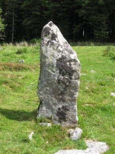
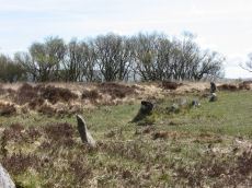
Hurston Ridge Standing Stone
Prehistoric Dartmoor Walks: Dartmoor Site: Hurston Ridge Double Stone Row
OS Map: SX 67268 82444
HER: MDV6541
Megalithic Portal: 8345
PMD: Hurston Ridge Standing Stone
ShortName: SS Hurston
Butler map: 25.9
DPD page: 136
Notes: Hurston Ridge is one of the best examples of a double stone now on Dartmoor. At the south end is a cairn 22 feet in diameter. The space between the rows widens intentionally as it approaches the cairn. The first stone from the south in the eastern row is the largest stone and stands 5 feet 10 inches high. Crossing suggests this may have been the original Heath Stone.
Nearby sites: SX 67268 82444
Distance: 1.49km
Hurston Ridge Settlement
OS Map: SX 674 825
HER: MDV6668
Megalithic Portal: 34979
ShortName: ST Hurston
Butler map: 25.9
Nearby sites: SX 674 825
Distance: 1.53km

Hurston Ridge Stone Row
Prehistoric Dartmoor Walks: Dartmoor Site: Hurston Ridge Double Stone Row
OS Map: SX 67260 82437
HER: MDV6541
Megalithic Portal: 8345
The Stone Rows of GB: Hurston Ridge
PMD: Hurston Ridge Stone Row
ShortName: SR Hurston
Butler map: 25.9
Butler Vol 5: p.228 & Fig.161
DPD page: 136
Notes: .Worth: Watern Hill. "A stone alignment which includes two parallel lines of upright stones leading downslope for 143 metres from a round cairn. The lower end of the alignment is denoted by a blocking stone. Midway along the alignment a length of later enclosure walling crosses the row. The cairn at the upper end of the alignment measures 5.9 metres in diameter and stands up to a height of 0.6 metres. A large slab denoting the north eastern edge of the cairn may represent a second blocking stone of the associated alignment." A number of the stones were restored to their original sockets in 1894. A broken hand axe was discovered in the pit in which one of the stones had stood near to the menhir next to the cairn. First observed by Mr. George French of Postbridge.
Nearby sites: SX 67260 82437
Distance: 1.48km
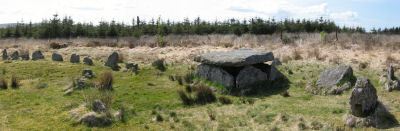
King's Oven (Water Hill) Cairn
OS Map: SX 67158 81299
HER: MDV6674
Megalithic Portal: 34690
PMD: Water Hill Possible Chambered Cairn
Alternate name: Water Hill 1 Cairn
ShortName: CN WaterHill 1
Butler map: 26.5.1
Butler Vol 5: p.156 & Fig.95
Grinsell: CHA 6
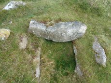
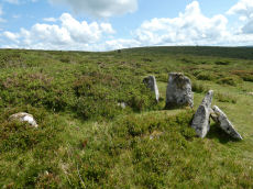
Notes: Situated at SX 67158129 on the rounded summit of Water Hill is the remains of a substantial round cairn 18.0 metres in diameter and up to 1.4 metres high in the east and 0.9 metres in the west. The whole of the central area of the cairn has been robbed to construct a superimposed modern boundary cairn 4.0 metres in diam and 2.1 metres high. This has given a 'dished' appearance to the cairn proper. Several large slabs averging 0.8 metres by 0.7 metres scattered around the base of the boundary cairn may be the remains of a destroyed cist.
The southern flat topped cairn measures 18 metres in diameter and 1.5 metres in height and is surmounted by a modern stone pile. A large slab situated to the south of this pile may have been part of a cist.
Nearby sites: SX 67158 81299
Distance: 0.45km
Kraps Ring Enclosed Settlement
OS Map: SX 64444 78157
HER: MDV5861
Megalithic Portal: 11477
ShortName: ES:KrapsRing
Notes: HER: A large sub-circular enclosure of 120 metres by 113 metres containing at least nine hut circles, almost entirely surrounded by the mature conifers in Bellever Plantation. There are two hut circles associated with the enclosure outside the pound wall on the south-western side.
Nearby sites: SX 64444 78157
Distance: 4.12km
Lakehead Hill Cairn Circle
Prehistoric Dartmoor Walks: Dartmoor Site: Lakehead Hill
OS Map: SX 64351 77493
HER: MDV52762
Megalithic Portal: 24365
Alternate name: Lakehead Hill 5 Cairn Circle
ShortName: CC Lakehead 5
Butler map: 27.19.5
DPD page: 117
Grinsell: LYD 55
Turner: G24
Barrow Report: 54
Notes: Butler Cairn 5. Tuner lists this as G24 Stone Circle. However, it is clear from its size and location near other Ring Settings that it is in fact better described as a Ring Setting despite having no visible internal structure. In these listings we will leave it as a cairn circle. HER: A ring cairn lying on a gentle slope near the summit of Lakehead Hill. The cairn is defined by a circle of edge set stones which measure 7.8 metres in diameter and stand up to 0.9 metres high. DEC Report 3: A second small kistvaen within a circle exists on the west side of Lake Head Hill, and was examined, but nothing was found in it. The circle about it is tolerably complete and the stone chest has lost only one of the side-stones ; but it is very small. Apparently a small stone row led from it. Near the kistvaen is a circle of stones enclosing a cairn, but no kistvaen. From the circle perhaps a stone row led away east, but only three stones remain in line. Lethbridge diagram p.114 and photo top p.117.
Nearby sites: SX 64351 77493
Distance: 4.66km
Lakehead Hill Platform Cairn Circle
Prehistoric Dartmoor Walks: Dartmoor Site: Lakehead Hill
OS Map: SX 64358 77773
HER: MDV5869
Megalithic Portal: 1057
Alternate name: Lakehead Hill 1 Platform Cairn Circle
ShortName: PC Lakehead 1
Butler map: 27.19.1
DPD page: 114
Grinsell: LYD 53
Turner: E16
Barrow Report: 55
Notes: HER: A ring cairn lying on a gentle slope near the summit of Lakehead Hill. The cairn survives as a 6 metre diameter circle of upright slabs standing up to 0.4 metres high surrounding a slightly raised area. In the centre of the circle is a small 0.15 metre high mound. Lethbridge diagram p.114 and photo bottom p.114.
Nearby sites: SX 64358 77773
Distance: 4.45km
Lakehead Hill 2 Cist
Prehistoric Dartmoor Walks: Dartmoor Site: Lakehead Hill
OS Map: SX 64261 77701
HER: MDV5841
Megalithic Portal: 4612
PMD: Lakehead Hill NW.
ShortName: CT Lakehead 2
Butler map: 27.19.2
DPD page: 115
Grinsell: LYD 52
Barrow Report: 17 55
Notes: HER: The remains of a cairn on Lakehead Hill. It includes an 8 metre diameter and 0.1 metre high mound containing a north west to south east orientated cist measuring 0.9 metres long by 0.55 metres wide. The cist is now backfilled and protrudes 0.4 metres high above the present land surface. Part excavation of the cist in 1898 by the Dartmoor Exploration Committee, revealed flint knives and scrapers together with pottery fragments and charcoal. Scheduled. Further coverage on Lakehead Hill page. Lethbridge diagram p.114 and photos top p.115. Butler Lakehead Hill (Cairn 2 diagrams pp.48-52).
Nearby sites: SX 64261 77701
Distance: 4.57km
Lakehead Hill 4 (E of Summit) Stone Row
Prehistoric Dartmoor Walks: Dartmoor Site: Lakehead Hill
OS Map: SX 64498 77603
HER: MDV5870
Megalithic Portal: 2009
The Stone Rows of GB: Lakehead Hill East
PMD: Lakehead Great Cairn Stone Row
Alternate name: Lakehead Hill E Stone Row
ShortName: SR Lakehead E
Butler map: 27.19.4
DPD page: 116
Notes: HER: A stone alignment and a cairn with cist lying on a gentle slope near the summit of Lakehead Hill. The stone alignment survives as a single row of at least 11 stones leading westward towards the cairn and cist. The cairn measures 6.7 metres in diameter and is defined by several edge set stones, which in turn surround a large restored cist formed by five substantial upright slabs supporting a capstone measuring 2.2 metre long by 1.55 metres wide and 0.3 metres thick. Lethbridge diagram p.114 and photos p.116.
Nearby sites: SX 64498 77603
Distance: 4.48km
Lakehead Hill 4 (E or Summit) Ring Setting Cairn and Cist
Prehistoric Dartmoor Walks: Dartmoor Site: Lakehead Hill
OS Map: SX 64499 77611
HER: MDV5870
Megalithic Portal: 2009
PMD: Lakehead Hill Summit
Alternate name: Lakehead Hill 4 Ring Setting Cairn and Cist
ShortName: CT Lakehead 4
Butler map: 27.19.4
Butler Vol 5: p.59 & Fig.37
DPD page: 116
Grinsell: LYD 54
Turner: D6
Notes: A single stone row of at least 11 stones leading westward towards the cairn and cist. HER: The cairn measures 6.7 metres in diameter and is defined by several edge set stones, which in turn surround a large restored cist formed by five substantial upright slabs supporting a capstone measuring 2.2 metre long by 1.55 metres wide and 0.3 metres thick. Further coverage on Lakehead Hill page. Lethbridge diagram p.114 and photo top p.116. Butler Lakehead Hill (Cairn 4) - Vol. 2. Map 27.19.4 (diagrams pp.48-52). Breton p.35-36
Nearby sites: SX 64499 77611
Distance: 4.48km
Lakehead Hill 6 (Newtake) Ring Setting Cairn and Cist
Prehistoric Dartmoor Walks: Dartmoor Site: Lakehead Hill
OS Map: SX 64363 77475
HER: MDV5842
Megalithic Portal: 24365
PMD: Lakehead Hill Central
Alternate name: Lakehead Hill 6 Ring Setting Cairn and Cist
ShortName: CT Lakehead 6
Butler map: 27.19.6
DPD page: 117
Grinsell: LYD 56
Turner: D10
Barrow Report: 54 56
Notes: Further coverage on Lakehead Hill page. Lethbridge diagram p.114 and photo bottom p.117. Dixon #64. Bar Rep 54. Butler Lakehead Hill (Cairn 6) - Vol. 2. Map 27.19.6 (diagrams pp.48-52). HER: On a gentle slope near the summit of Lakehead Hill is a ring cairn and cist. The cairn measures 6.9 metres in diameter and contains a central cist. The cist protrudes 0.4 metres above the surrounding ground surface and is covered by a capstone measuring 1.7 metres long, 1.28 metres wide and 0.15 metre thick. DEC Report 3: A second small kistvaen within a circle exists on the west side of Lake Head Hill, and was examined, but nothing was found in it. The circle about it is tolerably complete and the stone chest has lost only one of the side-stones ; but it is very small. Apparently a small stone row led from it. Near the kistvaen is a circle of stones enclosing a cairn, but no kistvaen. From the circle perhaps a stone row led away east, but only three stones remain in line.
Nearby sites: SX 64363 77475
Distance: 4.67km
Lakehead Hill 7 (Newtake) Cist
Prehistoric Dartmoor Walks: Dartmoor Site: Lakehead Hill
OS Map: SX 64720 77395
HER: MDV5875
Megalithic Portal: 11137
PMD: Lakehead Hill E.
Alternate name: Lakehead Hill 7 Cist
ShortName: CT Lakehead 7
Butler map: 27.19.7
Butler Vol 5: p.184 & Fig.127
DPD page: 118
Grinsell: LYD 57
Barrow Report: 54
Notes: Butler Lakehead Hill (Cairn 7) - Vol. 2. Map 27.19.7 (diagrams pp.48-52).Further coverage on Lakehead Hill page. Lethbridge diagram p.114 and photo top p.118.
Nearby sites: SX 64720 77395
Distance: 4.50km
Lakehead Hill 8 Cist
Prehistoric Dartmoor Walks: Dartmoor Site: Lakehead Hill
OS Map: SX 64717 77178
HER: MDV5879
Megalithic Portal: 24377
PMD: Lakehead Hill SE.
ShortName: CT Lakehead 8
Butler map: 27.19.8
Butler Vol 5: p.61 & Fig.41
DPD page: 118
Grinsell: LYD 58
Barrow Report: 33 55
Notes: HER: Southern of two cists to east of trackway on south side of Lakehead Hill. The cist, which lies in a small cairn 4.5 metres diameter, is orientated north-north-west to south-south-east. Only three sides of the cist survive; the cap stone has also gone. It was excavated in 1914 when a pit containing charcoal was found.. Further coverage on Lakehead Hill page. Lethbridge diagram p.114 and photo bottom p.118. Butler Lakehead Hill (Cairn 8) - Vol. 2. Map 27.19.8 (diagrams pp.48-52). Discovered by Mr. George French of Postbridge.
Nearby sites: SX 64717 77178
Distance: 4.68km
Lakehead Hill S.E. Stone Row
Prehistoric Dartmoor Walks: Dartmoor Site: Lakehead Hill
OS Map: SX 64701 77409
HER: MDV5875
Megalithic Portal: 44544
The Stone Rows of GB: Lakehead Hill 2
PMD: Lakehead Hill 2 Stone Row
Alternate name: Lakehead Hill 2 Stone Row
ShortName: SR Lakehead SE
Butler map: 27.19.7
Butler Vol 5: p.184 & Fig.127
DPD page: 118
Barrow Report: 54
Notes: R.N. Worth The cist was examined in 1895/6 but nothing was found. It was surrounded by a double retaining circle and a stone row lead from it north west, of which ten stones remained, but these had sunk into the bog leaving only their tops showing. SRGB states: This description makes it clear that this is unlikely to be a stone row since a row composed of small stones would not have survived the ditch digging involved in the building of the hedge. It is much more likely that they represented stones exposed in the side of the ditch. HER also has: The stone row which falls in an afforested area could not be identified and has probably been destroyed
Nearby sites: SX 64701 77409
Distance: 4.50km
Lakehead Hill S.W. Stone Row
Prehistoric Dartmoor Walks: Dartmoor Site: Lakehead Hill
OS Map: SX 6418 7730
HER: MDV5844
Megalithic Portal: 45595
PMD: Lakehead Hill 6 Stone Row
ShortName: SRxLakehead SW
Butler map: 27.19.1
Notes: HER: Alleged Stone row recorded in 1946 but covered by a forestry plantation in 1979. At that time, 3 stones were visible, but it was uncertain whether they were part of the stone row. It may have been destroyed or covered by humus. Butler: Worth records a stone row on the south-west side of Lakehead Hill but this area has been overplanted and nothing can now be seen. The row was about 123 metres long orientated to the north-east and without any associated cairn.
Nearby sites: SX 6418 7730
Distance: 4.92km
Lakehead Hill Summit Stone Row
Prehistoric Dartmoor Walks: Dartmoor Site: Lakehead Hill
OS Map: SX 64367 77656
HER: MDV5930
Megalithic Portal: 2010
The Stone Rows of GB: Lakehead Hill Summit
PMD: Lakehead Hill 3 Stone Row
Alternate name: Lakehead Hill summit Stone Row
ShortName: SR LakeheadSum
Butler map: 27.19.3
DPD page: 115
Notes: HER: A stone alignment lying on a gentle slope near the summit of Lakehead Hill. It includes a 22 metre long, single row of at least 12 stones standing up to 0.75 metres high, aligned east to west.. Lethbridge diagram p.114 and photo bottom p.115.
Nearby sites: SX 64367 77656
Distance: 4.53km
Lakehead Newtake Cist
Prehistoric Dartmoor Walks: Dartmoor Site: Lakehead Hill
OS Map: SX 64677 78385
HER: MDV5955
Megalithic Portal: 45734
PMD: Lakehead Hill NE.
Alternate name: Lakehead Hill 9 Cist
ShortName: CT Lakehead 9
Butler map: 27.19.9
Butler Vol 5: p.60 & Fig.40
Grinsell: LYD 51
Barrow Report: 55
Notes: HER: Remains of a cist. It consists of a single sidestone, partly buried and aligned NW/SE, measuring 1.3m by 0.2m and 0.3m high. There was no sign of a surrounding cairn or trace of a retaining circle seen in 1979, both probably destroyed by afforestation. Considered but not recommended for scheduling. Butler Lakehead Hill - Vol. 2. Map 27.19.9 (diagrams pp.48-52). Further coverage on Lakehead Hill page.
Nearby sites: SX 64677 78385
Distance: 3.80km
Lowton Brook W. Settlement
OS Map: SX 663 834
HER: MDV104672
Megalithic Portal: 24262
ShortName: ST:LowtonBkW
Nearby sites: SX 663 834
Distance: 2.69km
Metherall Settlement
OS Map: SX 668 840
HER: MDV107529
Megalithic Portal: 15138
ShortName: ST:Metherall
Barrow Report: 56
Nearby sites: SX 668 840
Distance: 3.10km
Red Barrows Cairn
Prehistoric Dartmoor Walks: Dartmoor Site: Soussons Cairn Circle
OS Map: SX 67718 79650
HER: MDV6007
Megalithic Portal: 34986
PMD: Red Barrows
Alternate name: Red Barrows 1 Cairn
ShortName: CN RedBar 1
Butler map: 24.2.1
Grinsell: MAN 5
Notes: Four Bronze Age round barrows between 10 and 20 meters in diameter and 0.5 to 2.2 meters high. One barrow was excavated in 1902, finds included pottery and flints. See also HER records, 6004, 6005, 6006, 6007.
Nearby sites: SX 67718 79650
Distance: 1.35km
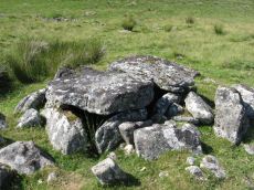
Roundy Park, Postbridge Cist
OS Map: SX 63920 79669
HER: MDV5935
Megalithic Portal: 26041
PMD: Roundy Park
Alternate name: Roundy Park Cist
ShortName: CT Roundy Pk 1
Butler map: 27.4
Butler Vol 5: p.22 & Fig.3
DPD page: 113
Grinsell: LYD 40
Barrow Report: 21
Notes: One of the largest cists on Dartmoor. Discovered in August 1893 by Robert Burnard, who was responsible for the restoration of the grave. Lethbrdige diagram p.112, photo p.113. Butler Vol. 2. Map 27.4 (diagram of location p.41, diagram of site Vol. 5 p.22). Breton p.37
Nearby sites: SX 63920 79669
Distance: 3.77km
Shapley Common Standing Stone
OS Map: SX 69992 82248
PMD: Shapley Common
ShortName: SS Shapley
Butler map: 23.5
Butler Vol 5: p.212
Notes: Possible standing stone, see Butler Vol V (1997) p 212.
Nearby sites: SX 69992 82248
Distance: 2.84km
Shapley Common Round House
OS Map: SX 6942 8206
HER: MDV6553
Megalithic Portal: 45859
ShortName: HC:ShapleyComm
DPD page: 128
Notes: Lethbridge p.128 Hut Circle on Shapley Common - particularly fine example.
Nearby sites: SX 6942 8206
Distance: 2.24km
Shovel Down Long Stone Standing Stone
Prehistoric Dartmoor Walks: Dartmoor Site: Shovel Down Ceremonial Complex
OS Map: SX 66031 85683
HER: MDV6149
Megalithic Portal: 10378
PMD: Shovel Down
ShortName: SS Long Stone
Butler map: 36.6
Butler Vol 5: p.56 & Fig.34
DPD page: 140
Notes: The Long Stone has been used as a boundary stone but it appears to be the terminal stone for a Bronze Age stone row and it may be of a contemporary date. Grinsell [Folklore 1976]: At the beating of the bounds of Gidleigh Common, the first man to reach the Long Stone is (or was) given a money prize. Fielden 1933. The current author has been informed this tradition continues. See also, Legendary Dartmoor: The Shoveldon Longstone
Nearby sites: SX 66031 85683
Distance: 4.92km
Shoveldown 1 Stone Row
Prehistoric Dartmoor Walks: Dartmoor Site: Shovel Down Ceremonial Complex
OS Map: SX 66049 85707
HER: MDV6181
Megalithic Portal: 2128
The Stone Rows of GB: Shoveldown 1
PMD: Shovel Down H-K Stone Row
ShortName: SR ShovelRow 1
Butler map: 36.7.1
DPD page: 139
Notes: Worth Row G, Butler Row 1. This row is considered to be one long partially robbed row. Previously listed here as Shoveldown D-G-H-J now Shoveldown 1 after Butler and Gerrard.
Nearby sites: SX 66049 85707
Distance: 4.94km
Shoveldown D Reported Stone Row
Prehistoric Dartmoor Walks: Dartmoor Site: Shovel Down Ceremonial Complex
OS Map: SX 66040 85680
HER: MDV6145
Megalithic Portal: 2128
The Stone Rows of GB: Shoveldown 1
PMD: Shovel Down H-K Stone Row
ShortName: SR:ShovelRow D
Butler map: 36.7.1
DPD page: 139
Notes: Worth Row D, Butler Row 1. This row is considered to be one long partially robbed row - previously listed as four separate rows.
Nearby sites: SX 66040 85680
Distance: 4.92km

Single Barrow Cairn
OS Map: SX 70576 79538
HER: MDV7487
Megalithic Portal: 16631
ShortName: CN SingleBarro
Butler map: 20.10
Butler Vol 5: p.23 & Fig.106
Grinsell: MAN 11
Notes: Round barrow, crowned by boundary stone dated 1854, and inscribed single burrow. Excavated 1873. Diameter 23 metres, height 1.0 metres. Butler Volume 1 Map 20.10.
Nearby sites: SX 70576 79538
Distance: 3.43km
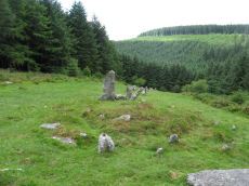
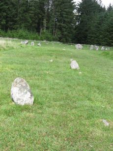
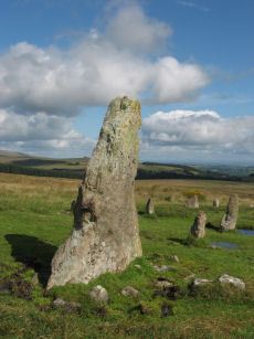
Sittaford Stone Circle
OS Map: SX 63017 82814
HER: MDV110432
Megalithic Portal: 35327
PMD: Sittaford Tor
ShortName: SC Sittaford
Notes: Discovered by Alan Endacott in 2007 as described in Devon Archaeological Society Newsletter No. 117 January 2014. Circle consists of 30 recumbent stones and has a diameter of 32m. It is about 1km from the Grey Wethers which are to the ENE. It is on the same arc as the previously known circles in northeastern Dartmoor.
Nearby sites: SX 63017 82814
Distance: 4.81km
Sittaford Tor Pound
OS Map: SX 6400 8287
HER: MDV6754
Megalithic Portal: 23218
ShortName: PD:Sittaford
Notes: "An oval enclosure lying within Great Stannon Newtake. It is defined by a 4.5m wide and 1.2m high rubble bank surrounding an internal area measuring 53.5m east to west by 39m north to south. An 8.3 metre wide entrance gap on the eastern side by a stony mound. The considerable size of the bank combined with its proximity to a number of ritual monuments within Great Stannon Newtake strongly supports that this enclosure is much more likely to have been used for ritual than domestic purposes and it has consequently been identified as a henge."
Nearby sites: SX 6400 8287
Distance: 3.95km
Sittaford Tor Ring Setting Cairn and Cist
OS Map: SX 63479 82641
HER: MDV21894
Megalithic Portal: 45792
PMD: Sittaford Tor
Alternate name: Sittaford Tor S. Ring Setting Cairn and Cist
ShortName: CT Sittaford
Butler map: 34.3
Butler Vol 5: p.183 & Fig.126
DPD page: 125
Turner: D25
Notes: "Cairn 5 metres in diameter, 0.75 metres high. Surrounded by two rings of kerb stones up to 0.75 metres high. Many stones forming the outer ring are recumbent. Mound material up to 0.2 metres high. Inner kerb is 2.8 metres diameter and the outer is 5 metres diameter. Slab in centre may be an intact cist. Grass and rushes. Animal poaching on western side of cairn.". "This mutilated kerbed cairn is situated on a peat-covered moorland slope below Sittaford Tor at 488m OD. It measures about 5m in diameter and comprises a probably (hidden) central cist set within twin concentric kerbs of granite slabs." Lethbridge photo bottom p.125. Butler Sittaford Tor S (Cairn 3) Vol. 2. Map 34.3 (p.112, also Butler Vol. 5. diagram p.183).
Nearby sites: SX 63479 82641
Distance: 4.32km
Soussons Common Ring Setting Cairn and Cist
Prehistoric Dartmoor Walks: Dartmoor Site: Soussons Cairn Circle
OS Map: SX 67516 78700
HER: MDV6013
Megalithic Portal: 1266
PMD: Soussons Plantation
Alternate name: Soussons Plantation S. Ring Setting Cairn and Cist
ShortName: CT Soussons Cm
Butler map: 24.2.6
DPD page: 124
Grinsell: MAN 9
Turner: D2
Barrow Report: 22 23 45 56
Notes: "A 28 feet diameter cairn circle with a central cist (plan). The tallest stone in the cairn circle is about 2 feet high." "This cist measures at least 1.3 metres long by 0.5 metres wide and when excavated in 1903 two coils of human hair were found". Lethbridge p.124. Butler Soussons Plantation S - Vol. 2. Map 24.2.6 (diagrams pp. 18-20). Breton p.41.
Nearby sites: SX 67516 78700
Distance: 2.27km
Soussons Down (Red Barrows) Stone Row
Prehistoric Dartmoor Walks: Dartmoor Site: Soussons Cairn Circle
OS Map: SX 6767 7998
HER: MDV6015
Megalithic Portal: 2136
The Stone Rows of GB: Soussons Down
PMD: Red Barrows Stone Row
Alternate name: Soussons Down Stone Row
ShortName: SR Red Barrows
Butler map: 24.2
Notes: Triple row destroyed in 1946 Butler Vol. 5 p38, Vol. 2 Map 24.2 p.19. The row was associated with a cairn about 300m north of the four Red Barrow cairn group (SX 67 NE 3). Butler mentions that some of the stones of the row remained and these were observed and reported to Sandy Gerrard by Chris Jenkins.
Nearby sites: SX 6767 7998
Distance: 1.01km
South Teignhead Platform Cairn Circle
OS Map: SX 64084 82827
HER: MDV20908
Megalithic Portal: 45611
PMD: South Teignhead
ShortName: PC S Teignhead
Butler map: 35.17
Butler Vol 5: p.157
Turner: E4
Notes: Oval cairn measuring 12.0m x 8.0m. It is flat-topped apart from a slight hollow in the centre. It appears to have multiple concentric rings of spaced small stones set on edge, with at least six rings being visible on its north side. To the south-east some stones are set at right angles to the rings. Butler in Volume 5 p.157 refers to a 14 x 6 m long cairn on the southern slopes of White Ridge. Presumably he refers to this site. The PMD website states: "A small central hollow" (Robinson & Cosford) is a "possible cist" (Turner)
Nearby sites: SX 64084 82827
Distance: 3.85km

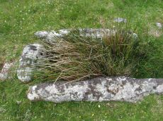
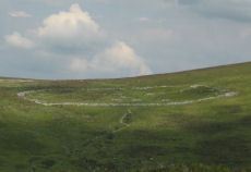
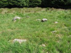
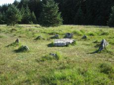
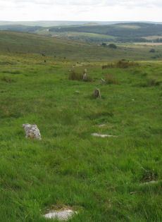
South Teignhead / White Ridge Stone Ring Cairn Circle
OS Map: SX 64168 82656
HER: MDV6771
Megalithic Portal: 35830
PMD: Teignhead Henge
Alternate name: South Teignhead Pound Stone Ring Cairn Circle
ShortName: RC White Ridge
Butler map: 35.18
Turner: A5
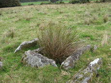
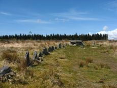
Notes: A small circular 'pound' about 0.5km SE of Grey Wethers. It measures 75ft (N-S) by 66ft; the bank composed of small stone and earth is 6-8ft wide and 3ft high. An entrance on the W has one door jamb standing. Turner listed this as a ring cairn A5 but also suggested it as a possible henge monument.
The author revisited this site with Steve Szypko on 16/05/25. It is hard to find so the photo has been annotated with a red highlight to bring out the feature, Steve stands to the side giving scale.
Nearby sites: SX 64168 82656
Distance: 3.70km
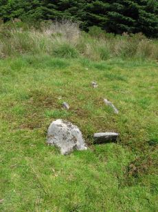
Stannon Little Newtake Ring Setting Cairn and Cist
OS Map: SX 65464 81068
HER: MDV6616
Megalithic Portal: 37598
PMD: Stannon Newtake
Alternate name: Stannon Newtake E. Ring Setting Cairn and Cist
ShortName: CT Stannon 1
Butler map: 35.21.1
DPD page: 124
Grinsell: LYD 29
Turner: D16
Barrow Report: 57
Notes: "Cairn survives as a 4.5 metre diameter mound up to 0.5 metres high. The western edge is denoted by a kerb of edge set slabs up to 1.15 metres high. The eastern edge is beneath a later boundary bank. A cist in the centre is a rectangular pit 1.2 metres by 0.5 metres denoted by edge set slabs". Butler Stannon Newtake E. - Vol. 2. Map 35.21 (diagram p.168). Visited again by the author 18/07/2025 and quite overgrown - the outer kerb can be seen but the cist is covered by vegetation. Breton p.45.
Nearby sites: SX 65464 81068
Distance: 2.00km

Stannon Newtake Stone Row
OS Map: SX 65348 81091
HER: MDV54555
Megalithic Portal: 2144
The Stone Rows of GB: Stannon Newtake
PMD: Stannon Newtake Stone Row
ShortName: SR Stannon New
Butler map: 35.21
Notes: HER: A group of four edge set stones standing up to 1 metre high, situated to the southeast of the cairn, represent the remains of a stone alignment. Possible extension of the White Ridge Stone Row. "Standing stones, possibly a stone row. Forty-six feet S. of the cairn (SX 68 SE 23) are two standing stones, two and a half feet high, their broad planes facing the monument. These, and two others in line, suggest the remains of a stone row, destroyed for materials for an ancient hedge. If a row, it does not point to the centre of the cairn." Gerrard: Following vegetation clearance by the Dartmoor Preservation Association it was found that this line of stones forms part of the White Ridge stone row and is not a row in its own right. Radcliffe: In their Fifth Report, the Dartmoor Exploration Committee considered there to be a row to the SSW of a ruined cairn. In 1983. this was found, by TAPG and Rosemary Robinson (pers comm, see Fleming 1983) to be an extension of White ridge stone row. See also: White Ridge Stone Row Cairn
Nearby sites: SX 65348 81091
Distance: 2.11km
Stonetor Hill Stone Ring Cairn Circle
OS Map: SX 6520 8536
HER: MDV48856
Megalithic Portal: 3478
Alternate name: Stonetor Hill 4 Stone Ring Cairn Circle
ShortName: RC:Stonetor 4
DPD page: 133
Turner: A3
Notes: Possible pound? "The feature consists of a sub-circular earthern bank 25m in diameter and up to 0.4m in height. It is best preserved on the North side where the bank is well defined, flat topped and has a plan width of about 4.0m On the South side the bank has been spread and flattened but still survives to 0.5m in height as a prominent outward-facing scarp, where the natural ground surface falls away from the enclsure. There is no entrance through the bank."
Nearby sites: SX 6520 8536
Distance: 4.94km
Thornworthy Cist
OS Map: SX 66746 84348
HER: MDV6613
Megalithic Portal: 15453
PMD: Thornworthy
ShortName: CT Thornworthy
Butler map: 35.22
Butler Vol 5: p.64 & Fig.42
DPD page: 137
Grinsell: CHA 3
Turner: E39
Barrow Report: 16 21 56
Notes: Butler Vol. 2. Map 35.22 (p.169, photo on p.136, diagram Vol. 5. p.64).Originally there was a second slightly smaller cist. This was removed after the excavation and re-erected at Torquay Museum. It is now at the High Moorland Visitor Centre at Princetown. See also: Thornworthy 2 Cist
Nearby sites: SX 66746 84348
Distance: 3.45km

Thornworthy Corner (N) Cist
OS Map: SX 66113 85468
HER: MDV6183
Megalithic Portal: 45776
PMD: Downhill from Three Boys
Alternate name: Thornworthy Corner N. Cist
ShortName: CT Thornwort N
Butler map: 36.7
Grinsell: CHA 2
Notes: "Recorded as a cist by Worth (1932), based on the one remaining stone. 1991 survey thought it more likely the result of stone clearance for the nearby newtake wall" Butler Vol. 2. Map 36.7.
Nearby sites: SX 66113 85468
Distance: 4.69km
Three Boys Standing Stone
OS Map: SX 66028 85486
HER: MDV6180
Megalithic Portal: 10369
The Stone Rows of GB: Shoveldown 6
PMD: Three Boys
ShortName: SS Three Boys
Butler map: 36.6
Notes: Terminal for stone row - one of 3 stones. 3 standing stones, of which only one remains; sometimes claimed as remains of burial chamber. This record has two entries, this one as a standing stone as widely reported, but also as reported cairn or tomb, see Three Boys Reported Cairn, SiteID=1268
Nearby sites: SX 66028 85486
Distance: 4.74km
Two Barrows Stone Ring Cairn Circle
OS Map: SX 70654 79219
HER: MDV7409
Megalithic Portal: 16632
Alternate name: Two Barrows 1 Stone Ring Cairn Circle
ShortName: RC TwoBarrows1
Butler map: 20.11.1
Butler Vol 5: p.23 & Fig.106
Grinsell: MAN 12
Barrow Report: 21 56
Notes: "The northern barrow was excavated in 1872. It measures 40 feet in diameter and 4 1/2 feet high. A ring of stones encircled the barrow and in the centre was a small cairn. A cremation burial was found to the SE of the centre covered by five flat stones. With the cremation was the blade of a bronze dagger and a pommel made from amber with a decoration consisting of rows of gold pins" See: Bate, C Spence, Researches into Some Antient Tumuli on Dartmoor, T.D.A. Vol. 5 pp.549-58 (1872). Relevant Butler map Vol. 1. Map 20. Butler Volume 1 Map 20.11 Two Barrows 1. [N.b. Treated as Turner type Stone Ring Cairn circle from the description].
Nearby sites: SX 70654 79219
Distance: 3.64km
Two Barrows S Cairn
OS Map: SX 70663 79203
HER: MDV7411
Megalithic Portal: 16632
Alternate name: Two Barrows 2 Cairn
ShortName: CN TwoBarrows2
Butler map: 20.11.2
Butler Vol 5: p.23 & Fig.106
Grinsell: WID 3
Notes: Two Barrows 2. An oval, stony mound measuring 15.5m E-W and 10.5m N-S. It stands up to 1.1m high and was probably originally bowl-profiled. The N slope is spit by a narrow path and a N-S slope across the top of the barrow has caused minor damage. It appears to be unexcavated. The mounds is crossed by a maintained drystone field wall, approaching from the SE and turning W on the barrow. The wall is built over the mound and does not seem to have caused much damage. This barrow appears to have been a target point for a reave, Fleming's Hameldon South, approaching from the E and stopping 3.5m short of the mound. The reave line is continued W by the modern wall beyond the barrow. See also: Bate, C Spence, Researches into Some Antient Tumuli on Dartmoor, T.D.A. Vol. 5 pp.549-58 (1872). Butler Volume 1 Map 20.11
Nearby sites: SX 70663 79203
Distance: 3.66km
West Vitifer Cist
OS Map: SX 67575 82802
HER: MDV6615
Megalithic Portal: 34980
PMD: Chagford Common
ShortName: CT WestVitif 1
Butler map: 25.11
Grinsell: CHA 4
Barrow Report: 16
Notes: "Possible location of a Bronze Age cist, although when subject to field investigation in November 2002 the site was not found" "The cairn was partially excavated in 1897 by the Barrow Committee of the Devonshire Association. This working revealed a ring of slabs surrounding a cist which had not been previously examined. In the cist there was a complete Bronze Age beaker together with charcoal but no trace of a burial." Cairn survives, restored urn thought to be in Plymouth museum. See: Sixteenth Barrow Report 1897. Butler Vol. 2. Map 25.11 ( p.32).
The author visited this site on 10 May 2024. I took photos of a possible candidate but I was unconvinced I had located the site so a wide search was undertaken of the vicinity within approx. 100 m. My initial conclusion is that the site cannot be located. However, as a desktop exercise on 23/05/24 I'm inclined to think I had actually located it. It is the dip behind the stone which appears on the RHS of the photo. This coincides within a very short distance with the location I had previously determined using satellite and also to the location given in the scheduled monument SX 67571 82800.
Nearby sites: SX 67575 82802
Distance: 1.84km
White Ridge Standing Stone
OS Map: SX 64162 82653
HER: MDV6771
Megalithic Portal: 51338
PMD: South Teignhead
Alternate name: South Teignhead Standing Stone
ShortName: SS White Ridge
Butler map: 35.18
Notes: Possible recumbent standing stone. "A small circular 'pound' about 350 yards (sic) SE of Grey Wethers. It measures 75ft (N-S) by 66ft; the bank composed of small stone and earth is 6-8ft wide and 3ft high. An entrance on the W has one door jamb standing; this was excavated but nothing was found except a very fine flat stone on the subsoil which measured 9ft long by 3-4ft wide. Trial pits were dug inside the enclosure without success." TDA Vol. 34 pp.164 (1902)
Nearby sites: SX 64162 82653
Distance: 3.70km
White Ridge Stone Row
OS Map: SX 65420 81661
HER: MDV6642
Megalithic Portal: 4145
The Stone Rows of GB: White Ridge
PMD: White Ridge Stone Row
ShortName: SR White Ridge
Butler map: 35.20
DPD page: 125
Notes: "A double stone row, 620 ft in length from the centre of a cairn at the north end, running nearly due south and slightly downhill. Well preserved at the north end for a short distance but becoming more dilapidated as it approaches the newtake wall at the south end". Lethbridge diagram p.124 and photo top p.125. Breton p.45 sadly robbed to build the wall, but the upper part is still a good specimen of the double avenue. It is 260 yds. long; there are three stones on the S. side of the wall.
It is now thought this row continues the other side of the newtake wall and possibly leads to the Stannon Newtake row which is the terminal end. Remains beyond the wall are sparse but possibly exposed following vegetation clearance by the Dartmoor Preservation Association.
The author re-visited this site on 18/07/2025. The summer of 2025 at a similar time of year to 2014. The row seems to be far more overgrown by purple moor grass. Few of the 2014 stones can be seen today.
See also: Stannon Newtake Stone Row
Nearby sites: SX 65420 81661
Distance: 2.15km

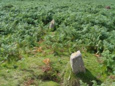
Yardworthy Stone Row
OS Map: SX 67605 84395
HER: MDV61337
Megalithic Portal: 6333471
The Stone Rows of GB: Yardworthy
PMD: Yardworthy
ShortName: SR Yardworthy
Notes: Quinnell quoted on HER: Stone row in Yardworthy Newtake, an area of rough pasture that has since undergone some stone clearance. Apparently the remains of a double row it starts 3.0 metres from a low barrow at SX67608438 and extends to the north-east for 7.0 metres. The north-west side consists of four stones, 2.0 to 2.5 metres apart. The south-eastern side about 1.4 metres distant has only one stone and two turf humps which may conceal others. Visible stones are barely 0.1 metres high. Immediately beyond the north-east end is a hollow or stone pit about 4.0 by 2.0 metres diameter. This, and clearance in the area may have destroyed any continuation.
The stones of the row are around 20 cm in length and almost impossible to photograph as a collection. There is a goood plan to the site on the Stone Rows of great Britain linked in the listings above.
The site was visited by the author and Steve Szypko on 03/03/2025 and we found 3 of the 4 stones reportedly visible - the other may have been under surface water. It is almost impossible to capture these small stones in one photo so a montage of 4 photos is linked to this record; the cairn and the 3 stones found. The cairn and row was difficult to find.
The stones of the stone row stones were recorded on a Garmin GPS device at: SX 67605 84398, SX 67605 84395, SX 67606 84395. The cairn is centred at SX 67601 84390.
Nearby sites: SX 67605 84395
Distance: 3.43km