
Prehistoric sites within 5km of SX 60925 75021
Guidance for walkers: The monuments featured in this database are archaeological treasures and need to be protected and preserved - please do not disturb any sites. Please check access and firing times before visiting sites, not all sites listed are on open access land. Firing ranges and boundaries of open access areas are marked on the OL28 OS Dartmoor Explorer map. Please stick to the country code and consider giving support to the numerous agencies that help to keep Dartmoor a fabulous natural and historic environment!
About the database listings: In all listings clicking on the photo or the site name will open a page for the site with a larger photo and further details from the database. The database now has over 6680 records covering nearly all publicly listed sites on Dartmoor including around 4800 round houses. This level of detail is of interest to archaeologists but tends to swamp listings of sites more likely to be of interest for walkers. For this reason, the listings default to around 550 core sites only. These are the stone circles, stone rows and the ring cairns listed by Turner. The default search radius is 2 km. The controls below the map can be used to start a new search by entering a 6- or 8-digit reference (without the prefix "SX"). The search radius can be specified and you can add incremental Display layers of detail on top of the core sites. If using a more detailed layer you will need to decrease the search radius to avoid getting hundreds of search results.
- Core sites Default listing of core sites consisting of stone circles & rows and some of the major ring cairns.
- Plus cairns adds approx. 1000 cairns and other minor sites not included in the core listings but excluding round houses.
- Plus round houses adds approx. 4800 round houses.
- Plus non-sites adds in the records for sites that no longer exist or are not prehistoric sites.
- Plus duplicates adds records excluded as duplicates. Those maybe duplicate records in external listings (e.g. the Historic Environment Records). For example, some sites have been identified as cairns in some listings and interpreted as round houses in other listings and both records appear.
These listings have incorporated, matched up and merged all of the records from all of the major archaeological listings including: Worth, Grinsell, Turner, Butler, Bill Radcliffe, Sandy Gerrard, Megalithic Portal, the National Monument Records and the Historic Environment Records. The author would like to thank Bill, Sandy, the lovely people both at Megalithic Portal (especially Anne Tate who did an amazing job to link listings) and at ACE Archaeology for collaborative work over the years to synchronise and correct listings across the various websites which now interlink. A culmination of years of work the final merger of cairn records took 3 months of cross referencing in 2017 the result being a snapshot of the records at that time. This data has in turn been refined since by field work and research. The round house data was supplied by Sandy Gerrard. Grid references are in order of accuracy: from Google Earth satellite, if visible and found, from a Garmin GPS reading, if visited by the author and from the literature otherwise. Individual site pages will state the source of the grid reference and provide satellite imagery. If a site listing lacks a photo it has not yet been visited by the author in which case the grid reference is from the literature.
Currently the database only includes sites which can be represented by a grid reference. Reaves are not included as they require GIS shape technology which is beyond the current capability of this system. To see the sources for the records, look at the tables on the resources menu. The database listings can also be viewed on a Google map and downloaded as GPS datasets for Garmin devices.
Corrections, or any feedback or suggestions are very welcome, email: info@dartmoorwalks.org.uk.
NOTE: Clicking on the icons for each monument in the map will give the name of the site. You can zoom in and out and drag the map around.
List of sites within 5km of SX 60925 75021
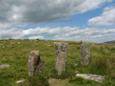
Littaford Tor E Cist
OS Map: SX 61846 76717
PMD: Littaford Tor E.
ShortName: CT Littaford 1
Notes: Radcliffe: "Long axis approx W-E . Stones visible on N ,E and S sides and some stone could be felt under grass on W side. Approx. 1m x 0.5m x 0.5m depth internally. No obvious sign of cairn mound. No obvious stonecutting in vicinity. TAP Greeves (pers. comm.) "
Nearby sites: SX 61846 76717
Distance: 1.93km
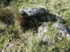
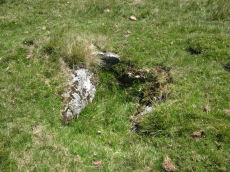
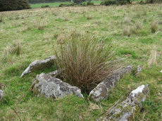
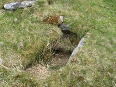
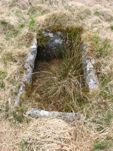
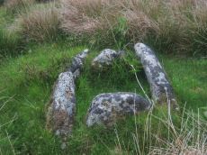
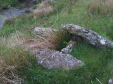
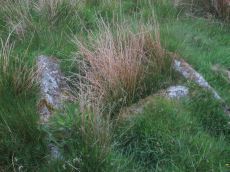
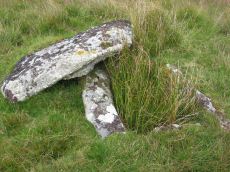
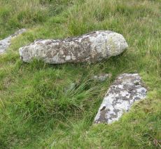
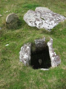
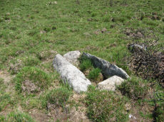
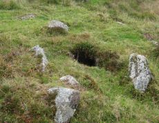
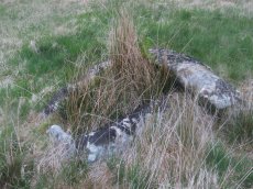
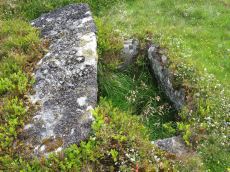
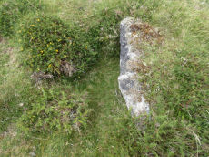
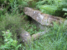
Crockern Tor 3 Reported Cist
OS Map: SX 61204 75824
ShortName: CT CrockernNW3
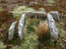
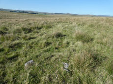
Notes: Possible cist reported by Nigel Rendle to Bill Radcliffe in 2008 NE of Crockern Farm. Bill comments Feb 2025 we were doubtful of it, as it is close to the path to Wistman's Wood, so how can it have been missed? But it looks good to me.. The author visited 25/09/2025 with Steve Szypko and these were my notes: there is an upright stone that looks like a possible displaced capstone and some other stones that could form a cist. This arrangement in itself is unconvincing but there is also a rectangular hole consistent with a cist. It is perhaps an unlikely but possible cist. NB. The grid reference has now been updated.
Nearby sites: SX 61204 75824
Distance: 0.85km
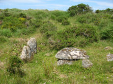
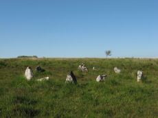
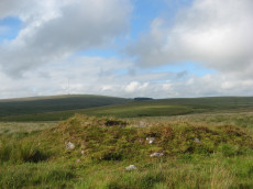
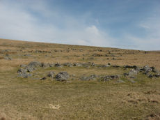
Arch Tor Platform Cairn Circle
OS Map: SX 63168 77843
HER: MDV21510
Megalithic Portal: 45618
Alternate name: Arch Tor 1 Platform Cairn Circle
ShortName: PC Arch Tor 1
Butler map: 27.6
Turner: E11
Notes: "A round cairn which survives as an 8.7 metre diameter mound standing up to 0.9 metres high. Large edge set stones on the north western edge of the mound may suggest the presence of a kerb which survives elsewhere as a buried feature."
Nearby sites: SX 63168 77843
Distance: 3.60km
Archerton Settlement
OS Map: SX 641 788
HER: MDV5931
Megalithic Portal: 42727
ShortName: ST:Archerton
Notes: An oval pound now planted with trees. Rowe noted remains of banks and a hut within the enclosure. Prowse mentions traceable sub-division banks with distinct evidence of nine hut circles and a further one, ten yards diameter, "close outside on the east". See: T.D.A. Vol. 23 pp.311-12
Nearby sites: SX 641 788
Distance: 4.94km
Archerton S.W. (Rowtor Brook) Ring Setting Cairn and Cist
OS Map: SX 62752 78808
HER: MDV5838
Megalithic Portal: 37604
PMD: Hollowcombe Bottom
Alternate name: Rowtor Brook 3 Ring Setting Cairn and Cist
ShortName: CT RowtorBr 3
Butler map: 27.17.3
Butler Vol 5: p.55 & Fig.33
DPD page: 112
Grinsell: LYD 42
Turner: D24
Barrow Report: 57
Notes: Breton: on N. side of wall is a kistvaen, around which is a triple circle, a very unusual feature..
HER: The cist lies within three concentric circles of stones at 10, 15 and 24 feet diameters, the inner ring being of large stones, the middle ring of smaller stones and the outer ring of even smaller stones. The cist measures internally 0.8m by 0.6m and 0.9m deep. Half of its capstone lies across its north end.
For more information see: Lethbridge Hollowcombe Bottom, diagram and photo p.112. Butler Rowtor Brook 3 - Vol. 2. Map 27.17 (diagram Vol. 5. p.55). Breton p.35
Nearby sites: SX 62752 78808
Distance: 4.20km
Archerton Tennis Ground Platform Cairn Circle and Cist
OS Map: SX 63852 78872
HER: MDV5839
Megalithic Portal: 37599
PMD: Archerton Tennis Court
Alternate name: Archerton Platform Cairn Circle and Cist
ShortName: CT Arch Tennis
Butler map: 27.18
DPD page: 114
Grinsell: LYD 45
Turner: E49
Barrow Report: 57
Notes: Lethbridge diagram p.112, photo top p.114. Butler Archerton - Vol. 2. Map 27.18. Breton p.37 Its four sides are complete, the capstone is partially buried; it stands on a slight mound and has been enclosed by a circle of small stones which are nearly buried under the turf.
Nearby sites: SX 63852 78872
Distance: 4.84km
Beardown Platform Cairn Circle and Cist
OS Map: SX 60330 78092
HER: MDV14690
Megalithic Portal: 42853
PMD: Lydford Tor
Alternate name: Lydford Tor E. Platform Cairn Circle and Cist
ShortName: CT Beardown
Butler map: 29.17
Butler Vol 5: p.197 & Fig.140
DPD page: 109
Grinsell: LYD 41a
Turner: E27
Notes: "The cairn, 4.5 metres by 5.6 metres and 0.4 metres high has spread over the remains of a contiguous kerb 4.6 metres in diameter." ... "Three of the cist slabs lean inwards at the top, the fourth, east slab remains upright. The bottom of the cist contains several slabs. The coverstone is visible to the north west partially buried in the cairn." Lethbridge diagram p.107, photo top p.109. Butler Lydford Tor E Vol. 5. Map 29.17 (diagram Vol 5. p.197).
Nearby sites: SX 60330 78092
Distance: 3.13km
Beardown Farm Cist
OS Map: SX 604 754
HER: MDV5974
Megalithic Portal: 45789
PMD: Beardown Farm
ShortName: CTxBeardown Fm
Grinsell: LYD 46
Notes: The site is believed to have been destroyed many years ago Bray 1879 (included in listing as 130 in Grinsell list). Area is covered in Butler Vol 2 Map 29. "The remains of a cist surrounded by a rough pavement was examined by Mr Bray in September 1832 'two or three minutes walk north east of Beardown House' (at SX 604 754). Three stones of a four foot long cist stood six inches above ground level. A small piece of coarse pottery was found inside."
Nearby sites: SX 604 754
Distance: 0.65km
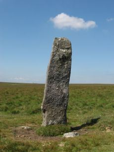
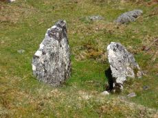
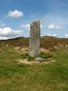
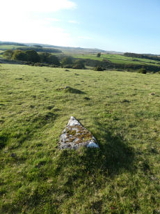
Beardown Man Standing Stone
OS Map: SX 59616 79634
HER: MDV4200
Megalithic Portal: 4144
PMD: Beardown Man Standing Stone
ShortName: SS BeardownMan
Butler map: 29.15
Butler Vol 5: p.220
DPD page: 108
Notes: A Bronze Age standing stone measuring 3.4m high, 1m by 0.4m in section and in good condition. One of the few isolated menhirs on Dartmoor. See also, Legendary Dartmoor: Dartmoor's Beardown Man. Lethbridge diagram p.107, photo p.108.
Nearby sites: SX 59616 79634
Distance: 4.80km
Bellever Settlement
OS Map: SX 646 767
HER: MDV5919
Megalithic Portal: 23723
ShortName: ST:Bellever
Notes: Hut circle at Bellever excavated in recent years. See also A dig in Devon reveals how life was lived 3,500 years ago: from cookery to DIY and Bellever's bustling Bronze Age uncovered
Nearby sites: SX 646 767
Distance: 4.04km
Bellever Tor (SW) Encircled Cairn
OS Map: SX 64144 76275
HER: MDV5885
Megalithic Portal: 3056
Alternate name: Bellever Tor 2 Encircled Cairn
ShortName: EC:Bellever 2
Butler map: 27.20.2
Grinsell: LYD 59a
Turner: F18
Notes: cairn, it does not appear to have been excavated, although there is a slight disturbance at the top centre where large granite stones are bared. At the north west extreme are two stones, the positions of which indicate this being part of the retaining circle, no others remain. Height 0.8m, diameter 5.0m. Turner F18. See also: Dartmoor Explorations: Antiquities of Black Newtake and Environs. NGR taken from Dartmoor Explorations (Steve Grigg).
Nearby sites: SX 64144 76275
Distance: 3.45km
Bellever Tor 1 (W) (Newtake) Platform Cairn Circle and Cist
Prehistoric Dartmoor Walks: Dartmoor Site: Lakehead Hill
OS Map: SX 64089 76472
HER: MDV5884
Megalithic Portal: 34876
PMD: Bellever Tor W.
Alternate name: Bellever Tor 1 Platform Cairn Circle and Cist
ShortName: CT Bellever 1
Butler map: 27.20.1
DPD page: 119
Grinsell: LYD 59
Turner: E26
Barrow Report: 54 56
Notes: Further coverage see the Lakehead Hill page. Lethbridge diagram p.119 (uppermost cist) and photo top p.119. Dixon #62. Bar Rep 54. Butler Bellever Tor (Cairn 1) - Vol. 2. Map 27.20.1 (diagram pp.52-3).
Nearby sites: SX 64089 76472
Distance: 3.48km
Bellever Tor N. Enclosed Settlement
OS Map: SX 64485 76808
HER: MDV27672
Megalithic Portal: 24263
ShortName: ES BelleverTor
Notes: The photo was taken at SX 64510 76849.
Nearby sites: SX 64485 76808
Distance: 3.98km
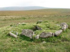
Black Newtake (b) Stone Ring Cairn Circle
Prehistoric Dartmoor Walks: Dartmoor Site: Lakehead Hill
OS Map: SX 63863 76038
HER: MDV5889
Megalithic Portal: 45841
Alternate name: Bellever Tor 4 Stone Ring Cairn Circle
ShortName: RC Bellever 4
Butler map: 27.20.4
DPD page: 119
Grinsell: LYD 61
Turner: A50
Barrow Report: 57
Notes: "Cairn visible as unbroken circular bank 11.5 metres in external diameter with a bank 2.4 to 3.7 metres wide by 0.75 metres high enclosing a flat platform circa 6 metres diameter and 0.5 metres above ground surface. Some small stones appear in the north and east margins, and several larger stones are visible on the platform." Lethbridge diagram p.119 (Cairn near Cist 1) - no photo.
NB. Butler cairns 4 and 5 had previously been transposed in the listings here. The original records for both have been retained and the Butler number corrected and the grid references corrected. This was previously listed as Butler cairn 5 and is now correctly identiifed as Cairn 4. See also: Dartmoor Explorations: Antiquities of Black Newtake and Environs
Nearby sites: SX 63863 76038
Distance: 3.11km
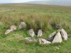
Black Newtake (C) No. 3 Ring Setting Cairn and Cist
Prehistoric Dartmoor Walks: Dartmoor Site: Lakehead Hill
OS Map: SX 63893 75869
HER: MDV5890
Megalithic Portal: 34908
PMD: Black Newtake Central
Alternate name: Bellever Tor 6 Ring Setting Cairn and Cist
ShortName: CT Bellever 6
Butler map: 27.20.6
DPD page: 120
Grinsell: LYD 62
Turner: D4
Barrow Report: 57
Notes: Further coverage on Lakehead Hill page. Lethbridge diagram p.119 Cist 2 and photo top p.120. Butler Bellever Tor - Vol. 2. Map 27.20.6 (Cairn 6 diagram pp.52-3).
Nearby sites: SX 63893 75869
Distance: 3.09km
Black Newtake (E) No. 5 Ring Setting Cairn and Cist
Prehistoric Dartmoor Walks: Dartmoor Site: Lakehead Hill
OS Map: SX 63853 75734
HER: MDV5950
Megalithic Portal: 45744
PMD: Black Newtake S.
Alternate name: Bellever Tor 8 Ring Setting Cairn and Cist
ShortName: CT Bellever 8
Butler map: 27.20.8
Grinsell: LYD 64
Turner: D7
Barrow Report: 57
Notes: "Turf and gorse covered cairn. Approximately 6 metres in diameter with a maximum height of 0.35 metres. A depression in the top possibly marks the site of a cist with one large leaning or recumbent stone detectable under the turf at the east end" "Small orthostatic circle, diameter 6.5 metres, with central cist. Only one stone remains. Part of group with similar thin rectangular slabs, now eroded". Further coverage on Lakehead Hill page. Butler Bellever Tor - Vol. 2. Map 27.20.8 (Cairn 8 diagram pp.52-3). See also: Dartmoor Explorations: Antiquities of Black Newtake and Environs
Nearby sites: SX 63853 75734
Distance: 3.01km
Black Newtake (N) No. 1 Ring Setting Cairn and Cist
Prehistoric Dartmoor Walks: Dartmoor Site: Lakehead Hill
OS Map: SX 63919 76067
HER: MDV5888
Megalithic Portal: 45738
PMD: Black Newtake N.
Alternate name: Bellever Tor 3 Ring Setting Cairn and Cist
ShortName: CT Bellever 3
Butler map: 27.20.3
DPD page: 119
Grinsell: LYD 60
Turner: D5
Barrow Report: 57
Notes: Further coverage on Lakehead Hill page. Lethbridge Cist 1 diagram p.119 and photo top p.119. Butler Bellever Tor (Cairn 3) - Vol. 2. Map 27.20.3 (diagram pp.52-3). Site revisited 04/09/23 and the site is very overgrown unlike in 2010. The exact location by Garmin is SX 63919 76067 now used on this record. See also: Dartmoor Explorations: Antiquities of Black Newtake and Environs
Nearby sites: SX 63919 76067
Distance: 3.17km
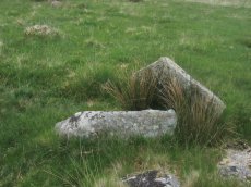
Blackabrook, East Cist
OS Map: SX 60528 73873
HER: MDV6252
Megalithic Portal: 45679
PMD: Blackabrook E.
Alternate name: Round Hill S.E.3 Cist
ShortName: CT Blackbrk E
Butler map: 65.3.3
DPD page: 104
Grinsell: LYD 82
Barrow Report: 31 44
Notes: "A well defined cist which has two stones supporting the slabs in the SE corner. The chamber measures 0.95m by 0.85m and about 0.4m deep. A turf-covered stony spread around the cist may be part of a robbed cairn." Lethbridge p.103 diagram Black Brook Cist(C), photo bottom p.104. Butler Round Hill S.E. 3 - Vol. 4. Map 65.3 (diagram of cists alongside the Blackbrook pp.230-1).
Nearby sites: SX 60528 73873
Distance: 1.21km
Blackabrook, South Cist
OS Map: SX 60524 73860
HER: MDV6254
Megalithic Portal: 45679
PMD: Blackabrook
Alternate name: Round Hill S.E.1 Cist
ShortName: CT Blackbrk S
Butler map: 65.3.1
DPD page: 103
Grinsell: LYD 80
Barrow Report: 31 44
Notes: "This cist with its displaced capstone lies on the edge of the river bank. Vestiges of the small surrounding cairn are now hidden under the turf. The chamber of the cist measures 1.25m by 0.55m and about 0.5m deep; the capstone is 1.5m long, 1.1m wide and 0.15m thick. The south stone has fallen outwards." Lethbridge p.103 diagram Black Brook Cist(A), photo p.103. Butler Round Hill S.E. 2. - Vol. 4. Map 65.3 (diagram of cists alongside the Blackbrook pp.230-1).
Nearby sites: SX 60524 73860
Distance: 1.23km
Blackabrook, West Cist
OS Map: SX 60522 73867
HER: MDV6253
Megalithic Portal: 45679
PMD: Blackabrook NW.
Alternate name: Round Hill S.E.2 Cist
ShortName: CT Blackbrk W
Butler map: 65.3.2
DPD page: 104
Grinsell: LYD 81
Barrow Report: 31 44
Notes: "The reed-filled cist is approximately 1.0m by 0.7m and about 0.2m deep. Peat has accumulated around the sides of the slabs but a few stones evident on the SW side may be part of a robbed cairn." Lethbridge p.103 diagram Black Brook Cist(B), photo p.104. Butler Round Hill S.E. 1 - Vol. 4. Map 65.3 (diagram of cists alongside the Blackbrook pp.230-1). Plan by R.H. Worth of in Barrow Report 31 includes plan of Blackabrook cairn group.
Nearby sites: SX 60522 73867
Distance: 1.22km
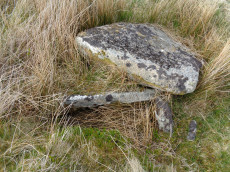
Blakey Tor (E) Cist
OS Map: SX 61312 73558
HER: MDV6245
Megalithic Portal: 28869
PMD: Blakey Tor E.
Alternate name: Blakey Tor E. Cist
ShortName: CT Blakey Tor
Butler map: 65.4
DPD page: 102
Grinsell: LYD 85
Barrow Report: 31 47
Notes: "A reed-filled cist is set well into the cairn on a NNW-SSE axis. The intact chamber measures internally 0.95m long, a maximum 0.65m wide and 0.45m deep; the longest side slab is 1.4m by 0.3m by 0.45m and largest end slab 0.55m by 0.2m by 0.4m. The coverstone against the NW side of the cist is roughly oval in shape and measures 1.7m by 1.3m and a maximum 0.25m thick." Lethbridge diagram p.102 Cist(B), photo p.102. Butler Vol. 4. Map 65.4 (diagram p.232).
Nearby sites: SX 61312 73558
Distance: 1.51km
Blakey Tor (W) Cist
OS Map: SX 61240 73551
HER: MDV6244
Megalithic Portal: 45772
PMD: Blakey Tor W.
Alternate name: Blakey Tor W. Cist
ShortName: CT BlakeyTor W
Butler map: 65.4
DPD page: 103
Grinsell: LYD 84
Notes: "The incomplete cist is oriented NW-SE. It measures about 0.85m long, 0.4m to 0.55m wide and 0.25m deep internally. The upright W side slab is 0.9m by 0.2m by 0.25m and the surviving end slab is 0.4m by 0.2m by 0.25m. The E side is formed by a flat-sided boulder which is c. 1.1m long, at least 0.6m thick and 0.25m high. The SE side is open. The coverstone is 1.7m by 0.7m by 0.4m and leans against the W side of the cist." Lethbridge diagram p.102 Cist(A), photo top p.103. Butler Blakey Tor W. - Vol. 4. Map 65.4 (diagram p.232).
Nearby sites: SX 61240 73551
Distance: 1.50km
Chittaford Down Platform Cairn Circle
OS Map: SX 63502 79203
HER: MDV5832
Megalithic Portal: 42726
PMD: Archerton
Alternate name: Chittaford Down 1 Platform Cairn Circle
ShortName: PC Chittaford1
Butler map: 27.18.1
Butler Vol 5: p.170 & Fig.109
Grinsell: LYD 38
Turner: E14
Notes: "Remains of a cairn, visible as a turf covered stony mound. The NE quadrant is robbed out but around the rest of the periphery are parts of a kerb of small boulders, some set on edge, giving a diameter of 6.5m NW-SE. Maximum height 0.6m in the SW quadrant, but elsewhere the interior is badly robbed." Butler says there is a possible end slab of a cist.
Nearby sites: SX 63502 79203
Distance: 4.91km
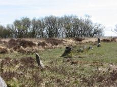
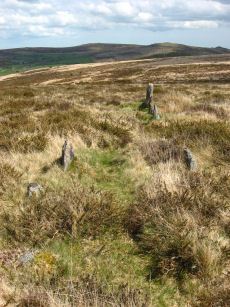
Conies Down Stone Row
OS Map: SX 58591 79076
HER: MDV4592
Megalithic Portal: 1846
The Stone Rows of GB: Conies Down
PMD: Conies Down Stone Row
ShortName: SR ConiesDown
Butler map: 30.11
DPD page: 107
Notes: "The Conies Down stone row is oriented a few degrees west of north-south and is 145m long. Originally a double alignment of stones, only three pairs of upright stones now survive. There are a total of 17 upright and 15 recumbent stones. The average gap between stones is 10m and between the pairs the gap is some 1.4m wide". Lethbridge diagram p.107.
Nearby sites: SX 58591 79076
Distance: 4.68km
Crock of Gold Ring Setting Cairn and Cist
OS Map: SX 61286 73076
HER: MDV6308
Megalithic Portal: 14960
PMD: The Crock of Gold
ShortName: CT CrockofGold
Butler map: 65.2
DPD page: 101
Grinsell: LYD 86
Turner: D17
Barrow Report: 27 47 56
Notes: "The cairn, 7m in overall diameter and 0.3m high, has a flattish top with a retaining circle set 1m to 1.5m within the perimeter. This consists of six earthfast boulders, about 0.4m across and protruding a similar height above the cairn ... A central cist is oriented NW to SE. Internally it is 0.8m long, 0.4m wide at the NW end, 0.5m at the SE, and 0.7m deep. The side slabs are 1m long and respectively 0.15m and 0.25m thick; the end slabs, 0.5m long and 0.1m thick. The capstone, moved to the W, is 1.3m long, 1.1m wide and 0.15m thick and now rests against the kerb." Lethbridge diagram p.102 Cist(C), photo p.101. Butler Vol. 4. Map 65.2 (diagram p.229).
Nearby sites: SX 61286 73076
Distance: 1.98km
Crockern Tor Cist
OS Map: SX 61414 76055
HER: MDV57569
Megalithic Portal: 45816
PMD: Crockern Tor
Alternate name: Crockern Tor 1 Cist
ShortName: CT CrockernNW1
Butler Vol 5: p.32 & Fig.11
DPD page: 110
Notes: "Remains of a small cairn with cist on a moderate W slope in open grassland at SX 61407604 overlooking the West Dart in Crockern Newtake. It has been robbed heavily, leaving only one cist slab and fragments of the cairn material. The slab is restangular in side view and in section, firmly embedded on edge, measuring 1.2m long 0.48m high and 0.15m thick. It is aligned NW to SE." Butler Vol 5 p. 32. Lethbridge diagram and photo p.110.
Nearby sites: SX 61414 76055
Distance: 1.14km
Crow Tor Platform Cairn Circle and Cist
OS Map: SX 60531 78683
HER: MDV5938
Megalithic Portal: 45775
PMD: Crow Tor
ShortName: CT Crow Tor
Butler map: 29.18
Butler Vol 5: p.196 & Fig.139
DPD page: 109
Grinsell: LYD 41
Turner: E39
Notes: "A kerbed cairn and cist. The cairn consists of a stony, turf-covered mound, and measures 4.5m in diameter and 0.45m in height. There are traces of a retaining kerb of leaning, granite slabs to the northeast and south. The cist is set slightly to the north of the centre of the cairn. It is trapezoidal in shape, and measures 0.65m and 0.95m in length, 0.8m in width, and 0.5m in depth. The cover-stone, which is 0.9m long, 0.5m wide and 0.2m thick, is displaced and lies just to the south east of the cist." Lethbridge diagram p.107, photo bottom p.109. Butler Vol. 2. Map 29.18 (p.63, photo on p.124, diagram Vol. 5. p.196).
Nearby sites: SX 60531 78683
Distance: 3.68km
Devil's Elbow Platform Cairn Circle
OS Map: SX 58192 72708
HER: MDV14310
Megalithic Portal: 36761
PMD: Devil's Bridge
Alternate name: Hart Tor N. Platform Cairn Circle
ShortName: PC:DevilsElbow
Butler map: 46.1
Butler Vol 5: p.168 & Fig.107
Grinsell: WAL 10
Turner: E5
Notes: Ring cairn consisting of a circle of close set stones: almost a kerb circle, interior flat and no sign of cist. Diameter 8m, height 0.3m. HER: Ring cairn to the north-east of the settlement to the north of Hart Tor recorded in the 19th century as containing a 'dilapidated kistvaen'
Nearby sites: SX 58192 72708
Distance: 3.58km
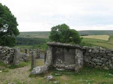
Dunnabridge Pound
Prehistoric Dartmoor Walks: Dartmoor Site: Dunnabridge Pound
OS Map: SX 6462 7465
HER: MDV6272
Megalithic Portal: 10635
PMD: Dunnabridge Pound
ShortName: PD Dunnabridge
Notes: Dunnabridge Pound probably has its origins in the prehistoric period as evidenced by the slight traces of hut circles within it. The pound underwent reconstruction in the medieval period and was used in the drifts to hold cattle found illegally pasturing on the moors. It was from this usage that the Judge's Chair got its name. "It occupies 0.9ha on a slight S slope, and is of rather oval form with greatest diameters of 110m by 122m. It is enclosed by a drystone wall 1.9m high and about 1m thick at the base, tapering towards the top. The material is mostly medium size moor stones with some large blocks and upright slabs incorporated at the base. The uneven interior is slightly raised at the southern perimeter and cut into the slope on the north, accompanied by a spread of stones, 1.5m long and 0.3m high, extending from the inner face and up to 0.6m high. The only entrance to be seen is the gated one on the S." See also, Legendary Dartmoor: Dunnabridge Pound
Nearby sites: SX 6462 7465
Distance: 3.71km
Dunnabridge Common Platform Cairn Circle and Cist
Prehistoric Dartmoor Walks: Dartmoor Site: Lakehead Hill
OS Map: SX 63585 75470
HER: MDV5952
Megalithic Portal: 37603
PMD: Smith Hill
Alternate name: Bellever Tor 9 Platform Cairn Circle and Cist
ShortName: CT Bellever 9
Butler map: 27.20.9
DPD page: 120
Grinsell: LYD 65
Turner: E37
Barrow Report: 58
Notes: Lethbridge Cist 3 diagram p.119 and photo bottom p.120. Butler Bellever Tor (Cairn 9) - Vol. 2. Map 27.20.9 (diagram p52-3). See also: Dartmoor Explorations: Antiquities of Black Newtake and Environs
Nearby sites: SX 63585 75470
Distance: 2.70km
Dunnabridge Pound Farm Newtake Cist
Prehistoric Dartmoor Walks: Dartmoor Site: Lakehead Hill
OS Map: SX 64086 75691
HER: MDV5891
Megalithic Portal: 45751
PMD: Dunnabridge Newtake
Alternate name: Bellever Tor 10 Cist
ShortName: CT Bellever10
Butler map: 27.20.10
Butler Vol 5: p.60 & Fig.39
DPD page: 121
Grinsell: LYD 66
Barrow Report: 59
Notes: Only one side of this cist remains. Further coverage on Lakehead Hill page. Lethbridge Cist 4 diagram p.119 and photo top p.121. Butler Bellever Tor - Vol. 2. Map 27.20.10 (Cairn 10 diagram pp.52-3). See also: Dartmoor Explorations: Antiquities of Black Newtake and Environs
Nearby sites: SX 64086 75691
Distance: 3.23km
Fox Tor Newtake, North Cist
OS Map: SX 62861 71177
HER: MDV6303
Megalithic Portal: 45677
PMD: Ter Hill N.
Alternate name: Ter Hill N.W.1 Cist
ShortName: CT FoxTorNew N
Butler map: 64.3.1
DPD page: 93
Grinsell: LYD 97
Barrow Report: 24 56
Notes: "The cist is 0.6m deep and 1.2m long, the NW end is 0.4m wide and SE end 0.6m wide; the NW end-slab, said by Burnard (1905)to be wedged in the bottom cannot be seen. The coverstone, resting on the NE side, is 1.6m by 1.3m at its extremeties". Lethbridge diagram (Cist A) and photo p.93. Butler Ter Hill N.W. 1 - Vol. 4. Map 64.3 (diagram p. 219).
Nearby sites: SX 62861 71177
Distance: 4.30km
Fox Tor Newtake, South Cist
OS Map: SX 62864 70964
HER: MDV6279
Megalithic Portal: 45678
PMD: Ter Hill S.
Alternate name: Ter Hill N.W.2 Cist
ShortName: CT FoxTorNew S
Butler map: 64.3.2
DPD page: 94
Grinsell: LYD 98
Barrow Report: 24 56
Notes: "The turf-covered cairn is, at maximum, 3.9m in diameter and 0.3m in height. The cist, oriented NW/SE, is approximately 1.3m by 0.55m, and 0.75m deep, and now almost hidden by the SW side stone which has fallen inwards. The NE end stone is not evident but an 0.7m high upright granite post retains part of the mound on this NE side. There is no trace of the coverstone". Lethbridge diagram p.93 (Cist B), top photos p.94. Butler Ter Hill N.W. 2 - Vol. 4. Map 64.3 (diagram p.219).
Nearby sites: SX 62864 70964
Distance: 4.50km
Foxtor Mires W. Platform Cairn Circle and Cist
OS Map: SX 60780 70484
HER: MDV12967
Megalithic Portal: 24008
PMD: Whiteworks
ShortName: CT FoxTorMireW
Butler map: 64.6
DPD page: 97
Turner: E19
Notes: "Seven large orthostats of the retaining circle remain in situ on the south and south-east side (see plan). The cist is entirely below ground level to a depth of 0.7m and measures 1.0m by 0.6m. The two endstones and two sidestones are visible; a stone which may be the coverstone lies on the ground to one side". Lethbridge diagram p.93, photos bottom p.97. Butler Foxtor Mires W. - Vol. 4. Map 64.6 (diagram p.222). Cairn with kerb circle, visible on N, E & W sides, with a central cist.
Nearby sites: SX 60780 70484
Distance: 4.54km
Goldsmith's Cross E.2. Ring Setting Cairn and Cist
OS Map: SX 61804 70321
HER: MDV6342
Megalithic Portal: 42707
PMD: Fox Tor Mires cairn
Alternate name: Goldsmith's Cross E.2 Ring Setting Cairn and Cist
ShortName: CT GoldsmithE2
Butler map: 64.5.2
DPD page: 95
Grinsell: LYD 95
Turner: D23
Notes: "West end stone of cist leans slightly inwards, otherwise a perfect cist measuring 0.75m NW-SE by 0.5m wide by 0.4m deep. Retaining circle of 7 stones averaging 0.4m high. No coverstone or barrow". Lethbridge diagram p.93, photo bottom right p.95 and on p.96. Turner D23 (Fox Tor Mire) - Proc Devon Arch Soc 48 (diagram p.45). Butler Goldsmith's Cross E. 2 - Vol. 4. Map 64.5 (Cairn 2 - diagram p.221).
Nearby sites: SX 61804 70321
Distance: 4.78km
Goldsmiths Cross E.1. Cist
OS Map: SX 61871 70395
HER: MDV61775
Megalithic Portal: 45806
PMD: Fox Tor Mires E.
Alternate name: Goldsmiths Cross E.1 Cist
ShortName: CT:GoldsmithE1
Butler map: 64.5.1
Notes: "Clear remains of cairn with cist. One side and one end stone of cist are in place. The western side stone may be beneath the turf, but the southern end stone and cover stone are missing. The internal dimensions of the cist are approximately 0.53 x 0.58 x 0.45 meters (1 foot 9 inches x 1 foot 11 inches x 1 foot 6 inches). Immediately around cist there was a backing of comparatively large flat stones.". Butler Goldsmith's Cross E. 1. Vol. 4. Map 64.5 (Cairn 1 - diagram p.221). There is no NMR for this site. There is an HER entry MDV61775 which matches precisely with the OS reference given by Butler. Butler describes: "The mound 0.1m high at best surrounds a slightly wedge-shaped cist of which only the sides, one composed of two stones, and an end are visible. The missing slab is probably buried in place".
Nearby sites: SX 61871 70395
Distance: 4.72km
Goldsmiths Cross E.3. Cist
OS Map: SX 61741 70204
HER: MDV6343
Megalithic Portal: 45748
PMD: Goldsmith's Cross
Alternate name: Goldsmiths Cross E.3 Cist
ShortName: CT:GoldsmithE3
Butler map: 64.5.3
DPD page: 95
Grinsell: LYD 94
Barrow Report: 58
Notes: "The NW sidestone, 0.8m long by 0.2m wide and the NE endstone 0.6m long, 0.15m wide are the only recognisable cist stones though it is possible that the SW side was formed by the two small slabs still visible and depicted by Worth. There is no coverstone". Lethbridge diagram p.93, photo bottom left p.95. Butler Goldsmith's Cross E.3. - Vol. 4. Map 64.5 (Cairn 3 - diagram p.221).
Nearby sites: SX 61741 70204
Distance: 4.89km
Hart Tor N. Settlement
OS Map: SX 5816 7243
HER: MDV3791
Megalithic Portal: 36762
ShortName: ST:HartTorN
Nearby sites: SX 5816 7243
Distance: 3.79km
Hart Tor North Stone Row
Prehistoric Dartmoor Walks: Dartmoor Site: Hart Tor Stone Row & Cairn Circle
OS Map: SX 57708 71708
HER: MDV4896
Megalithic Portal: 1973
The Stone Rows of GB: Hart Tor North
PMD: Harter N Stone Row
ShortName: SR Hart Tor N
Butler map: 46.5.1
DPD page: 25
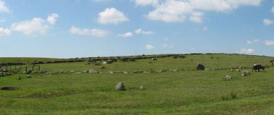
Notes: Butler Row 1. There are two cairns close by on the lower slopes of Hart Tor. One has an associated single stone row and the other has an associated double stone row - they diverge at an angle of 18 degrees. The double row consists of 93 stones and is much longer, around 122m in length [Gerrard], and extends all the way down to the River Meavy in the valley below. This row is fairly well preserved although it is crossed by a tinners ditch about a third of the way down its length and again by a leat a third of the way from the lower end. The structure was planned by Wilkinson in 1859 who states that the row is "terminated by a large monolith, now fallen, measuring about 25 feet long by 2 feet and 3 inches". Sadly this stone has long since disappeared. The row has pairs of stones which are spaced fairly accurately 1.9m apart along the rows, the rows being at a constant 1.7m separation. The cairn circle is 9.3m across and consists of 14 tall slabs some of which have fallen. Detailed survey of site in Hart Tor Stone Rows & Cairns, Meavy Valley Archaeology. Site Report No.9 - Sandy Gerrard (1999). See also: Sea Views at Hart Tor, The Stone Rows and Cairns at Hart Tor Dartmoor Part One and The Stone Rows and Cairns at Hart Tor Dartmoor Part Two
Nearby sites: SX 57708 71708
Distance: 4.62km

Hart Tor North Encircled Cairn
Prehistoric Dartmoor Walks: Dartmoor Site: Hart Tor Stone Row & Cairn Circle
OS Map: SX 57718 71716
HER: MDV49460
Megalithic Portal: 978
PMD: Harter N Stone Row
Alternate name: Hart Tor double stone row Encircled Cairn
ShortName: EC Hart Tor N
Butler map: 46.5
Butler Vol 5: p.39 & Fig.16
DPD page: 25
Grinsell: WAL 12
Turner: F12
Notes: The cairn circle is 9.3m across and consists of 14 tall slabs some of which have fallen. Wilkinson noticed concentric stone circles - which can't be seen today although there is clearly an inner circular mound. NMR A.
Nearby sites: SX 57718 71716
Distance: 4.61km
Hart Tor South Stone Row
Prehistoric Dartmoor Walks: Dartmoor Site: Hart Tor Stone Row & Cairn Circle
OS Map: SX 57720 71698
HER: MDV4895
Megalithic Portal: 1974
The Stone Rows of GB: Hart Tor South
PMD: Harter S Stone Row
ShortName: SR Hart Tor S
Butler map: 46.5.1
DPD page: 25
Notes: Butler Row 2. The single row consists of 16 stones and is 56.4m long, although Gerrard suggests it was probably once much longer. The single row leads to a cairn which does not have a retaining circle. The cairn which has been robbed measures 7.4m in diameter and up to 0.75m high. For early description of both rows and the now missing menhir, see: Wilkinson J. Gardner, British Remains on Dartmoor, Journal Brit. Arch. Assoc. xviii. pp.22-53 (1862). Detailed survey of site in Hart Tor Stone Rows & Cairns, Meavy Valley Archaeology. Site Report No.9 - Sandy Gerrard (1999). See also notes for Hart Tor North Stone Row. Sea Views at Hart Tor, The Stone Rows and Cairns at Hart Tor Dartmoor Part One and The Stone Rows and Cairns at Hart Tor Dartmoor Part Two
Nearby sites: SX 57720 71698
Distance: 4.62km

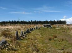
Higher White Tor Stone Row
OS Map: SX 61917 78362
HER: MDV5834
Megalithic Portal: 2192
The Stone Rows of GB: Higher White Tor
PMD: Higher White Tor Stone Row
ShortName: SR:HigherWhite
Butler map: 29.16
DPD page: 110
Notes: "A Late Neolithic stone alignment on Higher White Tor, surviving as two parallel rows of stones aligned roughly north-south. The alignment is 95.4 metres long and contains twelve upright stones and 24 recumbent ones." Lethbridge diagram and photo p.110. Site visited 28/05/2025 by the author. The main photo above gives a more realistic picture than the more "artistic" second photo.
Nearby sites: SX 61917 78362
Distance: 3.49km
Holmingbeam Cup Stone
OS Map: SX 59488 75233
HER: MDV12807
Megalithic Portal: 10606
ShortName: CS Holmingbeam
DPD page: 107
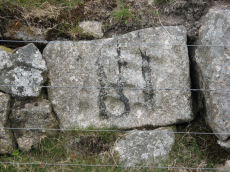
Notes: "Mortar stone of uncertain date incorporated into the eastern boundary wall of Long Plantation. It was formerly, erroneously, recorded as a cup-marked stone." The stone is upside down in wall by road side and has the figure 18 painted on it. Lethbridge diagram and photo p.107
Nearby sites: SX 59488 75233
Distance: 1.45km
Huccaby Rings Outer Enclosed Settlement
OS Map: SX 65553 74441
HER: MDV6397
Megalithic Portal: 4614
ShortName: ES HuccabyOut
Notes: "Outer Huccaby Ring earthwork; a sub-rectangular banked enclosure. The bank is grassed over rubble. There is a probable entrance on the south-west side. A hillslope enclosure in rough moorland measuring 105 metres east-west and 95 metres north-south with a bank of small stones averaging 0.6 metres high. It is of prehistoric date with later additions." In more recent years the formerly grass covered site has become gorse and heather covered as can be seen in the photo of the northern section. In 2022-2024 work has been done by the Dartmoor Preservation Association to clear the gorse from the bank.
Nearby sites: SX 65553 74441
Distance: 4.66km
Joan Ford's Newtake Cairn Circle
OS Map: SX 63033 72172
HER: MDV6261
Megalithic Portal: 3296
Alternate name: Joan Ford's Newtake 2 Cairn Circle
ShortName: CC Joan Fords
Butler map: 63.3.2
Grinsell: LYD 91
Turner: G22
Barrow Report: 30
Notes: "A stone circle with six identifiable erect or leaning stones. One forms the E post of the gateway, the west post, 7ft high, stands outside the circumference. It is because of its small diameter, without doubt a retaining circle; any internal features such as a central hollow or possible kistvean have been obliterated by the wall builders." Turner Stone Circle G22. Bar Rep 30.
Nearby sites: SX 63033 72172
Distance: 3.43km
Joan Ford's Newtake Embanked Cairn Circle and Cist
OS Map: SX 63143 72168
HER: MDV6260
Megalithic Portal: 3295
PMD: Joan Ford's Newtake
Alternate name: Joan Ford's Newtake 1 Embanked Cairn Circle and Cist
ShortName: CT Joan Fords
Butler map: 63.3.1
DPD page: 99
Grinsell: LYD 92
Turner: B7
Barrow Report: 30 56
Notes: "A low kerb within the disturbed fringes of the mound is 8.7m in diameter with more or less continuous upright slabs and boulders 0.3m to 0.6m high. A dry stone newtake wall crosses the N side and overlies part of the kerb. A well-preserved cist, oriented NW-SE, is internally 1.0m long, 0.5m to 0.65m wide and up to 0.7m deep. The coverstone leans against the SE side of the cist and measures 1.35m by 1.0m by 0.2." Lethbridge diagram p.99, photo bottom p.99. Butler Joan Ford's Newtake 1 - Vol. 4. Map 63.3 (diagram p.214).
Nearby sites: SX 63143 72168
Distance: 3.61km
Joan Ford's Newtake Stone Row
OS Map: SX 63183 71987
HER: MDV6375
Megalithic Portal: 1985
The Stone Rows of GB: Joan Fords Newtake
PMD: Joan Ford's Newtake
Alternate name: Joan Ford's Newtake Stone Row
ShortName: SR Joan Fords
Notes: Stone Rows of Great Britain states: A probable single stone row measuring 7.27m long, including at least three large-sized upright orthostats and two recumbent slabs situated on a gentle south east facing slope. The stones stand up to between 1.55m and 1.23m high, arranged in height order with the tallest at the east. The row is orientated ENE to NSW and has restricted views of several skyline cairns and surrounding landscape. Breton (p.19) ... just above the river are 3 large monoliths in a row; do they form the end of a stone row, or are they part of a vanished linhay? Both the late Mr. Robert Burnard and Mr. R. Hansford Worth told me they did not know what they are, and neither do I. All we can say is the stones are there.
Nearby sites: SX 63183 71987
Distance: 3.78km
Kraps Ring Enclosed Settlement
OS Map: SX 64444 78157
HER: MDV5861
Megalithic Portal: 11477
ShortName: ES:KrapsRing
Notes: HER: A large sub-circular enclosure of 120 metres by 113 metres containing at least nine hut circles, almost entirely surrounded by the mature conifers in Bellever Plantation. There are two hut circles associated with the enclosure outside the pound wall on the south-western side.
Nearby sites: SX 64444 78157
Distance: 4.71km
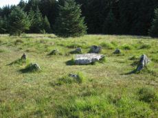
Lakehead Hill Cairn Circle
Prehistoric Dartmoor Walks: Dartmoor Site: Lakehead Hill
OS Map: SX 64351 77493
HER: MDV52762
Megalithic Portal: 24365
Alternate name: Lakehead Hill 5 Cairn Circle
ShortName: CC Lakehead 5
Butler map: 27.19.5
DPD page: 117
Grinsell: LYD 55
Turner: G24
Barrow Report: 54
Notes: Butler Cairn 5. Tuner lists this as G24 Stone Circle. However, it is clear from its size and location near other Ring Settings that it is in fact better described as a Ring Setting despite having no visible internal structure. In these listings we will leave it as a cairn circle. HER: A ring cairn lying on a gentle slope near the summit of Lakehead Hill. The cairn is defined by a circle of edge set stones which measure 7.8 metres in diameter and stand up to 0.9 metres high. DEC Report 3: A second small kistvaen within a circle exists on the west side of Lake Head Hill, and was examined, but nothing was found in it. The circle about it is tolerably complete and the stone chest has lost only one of the side-stones ; but it is very small. Apparently a small stone row led from it. Near the kistvaen is a circle of stones enclosing a cairn, but no kistvaen. From the circle perhaps a stone row led away east, but only three stones remain in line. Lethbridge diagram p.114 and photo top p.117.
Nearby sites: SX 64351 77493
Distance: 4.22km
Lakehead Hill Platform Cairn Circle
Prehistoric Dartmoor Walks: Dartmoor Site: Lakehead Hill
OS Map: SX 64358 77773
HER: MDV5869
Megalithic Portal: 1057
Alternate name: Lakehead Hill 1 Platform Cairn Circle
ShortName: PC Lakehead 1
Butler map: 27.19.1
DPD page: 114
Grinsell: LYD 53
Turner: E16
Barrow Report: 55
Notes: HER: A ring cairn lying on a gentle slope near the summit of Lakehead Hill. The cairn survives as a 6 metre diameter circle of upright slabs standing up to 0.4 metres high surrounding a slightly raised area. In the centre of the circle is a small 0.15 metre high mound. Lethbridge diagram p.114 and photo bottom p.114.
Nearby sites: SX 64358 77773
Distance: 4.40km
Lakehead Hill 2 Cist
Prehistoric Dartmoor Walks: Dartmoor Site: Lakehead Hill
OS Map: SX 64261 77701
HER: MDV5841
Megalithic Portal: 4612
PMD: Lakehead Hill NW.
ShortName: CT Lakehead 2
Butler map: 27.19.2
DPD page: 115
Grinsell: LYD 52
Barrow Report: 17 55
Notes: HER: The remains of a cairn on Lakehead Hill. It includes an 8 metre diameter and 0.1 metre high mound containing a north west to south east orientated cist measuring 0.9 metres long by 0.55 metres wide. The cist is now backfilled and protrudes 0.4 metres high above the present land surface. Part excavation of the cist in 1898 by the Dartmoor Exploration Committee, revealed flint knives and scrapers together with pottery fragments and charcoal. Scheduled. Further coverage on Lakehead Hill page. Lethbridge diagram p.114 and photos top p.115. Butler Lakehead Hill (Cairn 2 diagrams pp.48-52).
Nearby sites: SX 64261 77701
Distance: 4.28km
Lakehead Hill 4 (E of Summit) Stone Row
Prehistoric Dartmoor Walks: Dartmoor Site: Lakehead Hill
OS Map: SX 64498 77603
HER: MDV5870
Megalithic Portal: 2009
The Stone Rows of GB: Lakehead Hill East
PMD: Lakehead Great Cairn Stone Row
Alternate name: Lakehead Hill E Stone Row
ShortName: SR Lakehead E
Butler map: 27.19.4
DPD page: 116
Notes: HER: A stone alignment and a cairn with cist lying on a gentle slope near the summit of Lakehead Hill. The stone alignment survives as a single row of at least 11 stones leading westward towards the cairn and cist. The cairn measures 6.7 metres in diameter and is defined by several edge set stones, which in turn surround a large restored cist formed by five substantial upright slabs supporting a capstone measuring 2.2 metre long by 1.55 metres wide and 0.3 metres thick. Lethbridge diagram p.114 and photos p.116.
Nearby sites: SX 64498 77603
Distance: 4.41km
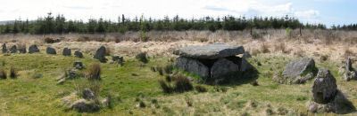
Lakehead Hill 4 (E or Summit) Ring Setting Cairn and Cist
Prehistoric Dartmoor Walks: Dartmoor Site: Lakehead Hill
OS Map: SX 64499 77611
HER: MDV5870
Megalithic Portal: 2009
PMD: Lakehead Hill Summit
Alternate name: Lakehead Hill 4 Ring Setting Cairn and Cist
ShortName: CT Lakehead 4
Butler map: 27.19.4
Butler Vol 5: p.59 & Fig.37
DPD page: 116
Grinsell: LYD 54
Turner: D6
Notes: A single stone row of at least 11 stones leading westward towards the cairn and cist. HER: The cairn measures 6.7 metres in diameter and is defined by several edge set stones, which in turn surround a large restored cist formed by five substantial upright slabs supporting a capstone measuring 2.2 metre long by 1.55 metres wide and 0.3 metres thick. Further coverage on Lakehead Hill page. Lethbridge diagram p.114 and photo top p.116. Butler Lakehead Hill (Cairn 4) - Vol. 2. Map 27.19.4 (diagrams pp.48-52). Breton p.35-36
Nearby sites: SX 64499 77611
Distance: 4.41km
Lakehead Hill 6 (Newtake) Ring Setting Cairn and Cist
Prehistoric Dartmoor Walks: Dartmoor Site: Lakehead Hill
OS Map: SX 64363 77475
HER: MDV5842
Megalithic Portal: 24365
PMD: Lakehead Hill Central
Alternate name: Lakehead Hill 6 Ring Setting Cairn and Cist
ShortName: CT Lakehead 6
Butler map: 27.19.6
DPD page: 117
Grinsell: LYD 56
Turner: D10
Barrow Report: 54 56
Notes: Further coverage on Lakehead Hill page. Lethbridge diagram p.114 and photo bottom p.117. Dixon #64. Bar Rep 54. Butler Lakehead Hill (Cairn 6) - Vol. 2. Map 27.19.6 (diagrams pp.48-52). HER: On a gentle slope near the summit of Lakehead Hill is a ring cairn and cist. The cairn measures 6.9 metres in diameter and contains a central cist. The cist protrudes 0.4 metres above the surrounding ground surface and is covered by a capstone measuring 1.7 metres long, 1.28 metres wide and 0.15 metre thick. DEC Report 3: A second small kistvaen within a circle exists on the west side of Lake Head Hill, and was examined, but nothing was found in it. The circle about it is tolerably complete and the stone chest has lost only one of the side-stones ; but it is very small. Apparently a small stone row led from it. Near the kistvaen is a circle of stones enclosing a cairn, but no kistvaen. From the circle perhaps a stone row led away east, but only three stones remain in line.
Nearby sites: SX 64363 77475
Distance: 4.22km
Lakehead Hill 7 (Newtake) Cist
Prehistoric Dartmoor Walks: Dartmoor Site: Lakehead Hill
OS Map: SX 64720 77395
HER: MDV5875
Megalithic Portal: 11137
PMD: Lakehead Hill E.
Alternate name: Lakehead Hill 7 Cist
ShortName: CT Lakehead 7
Butler map: 27.19.7
Butler Vol 5: p.184 & Fig.127
DPD page: 118
Grinsell: LYD 57
Barrow Report: 54
Notes: Butler Lakehead Hill (Cairn 7) - Vol. 2. Map 27.19.7 (diagrams pp.48-52).Further coverage on Lakehead Hill page. Lethbridge diagram p.114 and photo top p.118.
Nearby sites: SX 64720 77395
Distance: 4.48km
Lakehead Hill 8 Cist
Prehistoric Dartmoor Walks: Dartmoor Site: Lakehead Hill
OS Map: SX 64717 77178
HER: MDV5879
Megalithic Portal: 24377
PMD: Lakehead Hill SE.
ShortName: CT Lakehead 8
Butler map: 27.19.8
Butler Vol 5: p.61 & Fig.41
DPD page: 118
Grinsell: LYD 58
Barrow Report: 33 55
Notes: HER: Southern of two cists to east of trackway on south side of Lakehead Hill. The cist, which lies in a small cairn 4.5 metres diameter, is orientated north-north-west to south-south-east. Only three sides of the cist survive; the cap stone has also gone. It was excavated in 1914 when a pit containing charcoal was found.. Further coverage on Lakehead Hill page. Lethbridge diagram p.114 and photo bottom p.118. Butler Lakehead Hill (Cairn 8) - Vol. 2. Map 27.19.8 (diagrams pp.48-52). Discovered by Mr. George French of Postbridge.
Nearby sites: SX 64717 77178
Distance: 4.36km
Lakehead Hill S.E. Stone Row
Prehistoric Dartmoor Walks: Dartmoor Site: Lakehead Hill
OS Map: SX 64701 77409
HER: MDV5875
Megalithic Portal: 44544
The Stone Rows of GB: Lakehead Hill 2
PMD: Lakehead Hill 2 Stone Row
Alternate name: Lakehead Hill 2 Stone Row
ShortName: SR Lakehead SE
Butler map: 27.19.7
Butler Vol 5: p.184 & Fig.127
DPD page: 118
Barrow Report: 54
Notes: R.N. Worth The cist was examined in 1895/6 but nothing was found. It was surrounded by a double retaining circle and a stone row lead from it north west, of which ten stones remained, but these had sunk into the bog leaving only their tops showing. SRGB states: This description makes it clear that this is unlikely to be a stone row since a row composed of small stones would not have survived the ditch digging involved in the building of the hedge. It is much more likely that they represented stones exposed in the side of the ditch. HER also has: The stone row which falls in an afforested area could not be identified and has probably been destroyed
Nearby sites: SX 64701 77409
Distance: 4.47km
Lakehead Hill S.W. Stone Row
Prehistoric Dartmoor Walks: Dartmoor Site: Lakehead Hill
OS Map: SX 6418 7730
HER: MDV5844
Megalithic Portal: 45595
PMD: Lakehead Hill 6 Stone Row
ShortName: SRxLakehead SW
Butler map: 27.19.1
Notes: HER: Alleged Stone row recorded in 1946 but covered by a forestry plantation in 1979. At that time, 3 stones were visible, but it was uncertain whether they were part of the stone row. It may have been destroyed or covered by humus. Butler: Worth records a stone row on the south-west side of Lakehead Hill but this area has been overplanted and nothing can now be seen. The row was about 123 metres long orientated to the north-east and without any associated cairn.
Nearby sites: SX 6418 7730
Distance: 3.97km
Lakehead Hill Summit Stone Row
Prehistoric Dartmoor Walks: Dartmoor Site: Lakehead Hill
OS Map: SX 64367 77656
HER: MDV5930
Megalithic Portal: 2010
The Stone Rows of GB: Lakehead Hill Summit
PMD: Lakehead Hill 3 Stone Row
Alternate name: Lakehead Hill summit Stone Row
ShortName: SR LakeheadSum
Butler map: 27.19.3
DPD page: 115
Notes: HER: A stone alignment lying on a gentle slope near the summit of Lakehead Hill. It includes a 22 metre long, single row of at least 12 stones standing up to 0.75 metres high, aligned east to west.. Lethbridge diagram p.114 and photo bottom p.115.
Nearby sites: SX 64367 77656
Distance: 4.33km
Laughter Tor E. Stone Row
Prehistoric Dartmoor Walks: Dartmoor Site: Laughter Tor Stone Row
OS Map: SX 65222 75393
HER: MDV53417
Megalithic Portal: 2017
The Stone Rows of GB: Laughter Tor 1
PMD: Laugh Tor I Stone Row
Alternate name: Laughter Tor 1 Stone Row
ShortName: SR Laugh Tor E
Butler map: 28.12.1
DPD page: 122
Notes: Butler Laughter 1. Double row interrupted by a new-take wall. row is robbed near wall. "Bronze Age standing stone 2.65 metres high, 0.7 metres wide and 0.52 metres thick, set into a small cairn. About 18 metres to the south east is a double stone row orientated north west to south east and consisting of at least 23 upright stones and a further 9 displaced ones averaging about 1.7 metres apart. The standing stone was re-erected in 1893 and again in 1911 and the cairn was excavated in 1903". Lethbridge pp.121-122. Breton p.41.
Nearby sites: SX 65222 75393
Distance: 4.31km
Laughter Tor W. Stone Row
Prehistoric Dartmoor Walks: Dartmoor Site: Laughter Tor Stone Row
OS Map: SX 65207 75389
HER: MDV6002
Megalithic Portal: 52739
The Stone Rows of GB: Laughter Tor 2
PMD: Laugh Tor II Stone Row
Alternate name: Laughter Tor 2 Stone Row
ShortName: SR Laugh Tor W
Butler map: 28.12.2
Butler Vol 5: p.215 & Fig.149
DPD page: 122
Notes: Butler Laughter 2. "A double stone row at about 395m OD cuts across the gentle SW projecting spur of Laughter Tor in an area of heather and rough grass some 12m WSW of the standing stone 'Laughter Man'. The stones, although all relatively small in size, form two good slightly curving rows oriented about 295 degs. and 0.7m to 1.2m apart, consisting of thirteen stones extending from SX 6519075381 some 15m ESE to SX 6520475375. Now visible are six stones in each row with a single stone at the NW end. Originally there may have been at least ten in each row at intervals of about 1.2m". Lethbridge pp.121-122.
Nearby sites: SX 65207 75389
Distance: 4.30km
Laughtor Man Standing Stone
Prehistoric Dartmoor Walks: Dartmoor Site: Laughter Tor Stone Row
OS Map: SX 65223 75389
HER: MDV6001
Megalithic Portal: 2017
PMD: Laugh Tor Man
ShortName: SS Laughtor
Butler map: 28.12
Butler Vol 5: p.215 & Fig.149
DPD page: 122
Notes: The longstone is 2.4 m high and was found prostrate on a cairn which was excavated by Burnard. The cairn contained "a great quantity of charcoal and peat ashes". The longstone was restored in 1903. A double stone row heads to the longstone. Breton p.41 a huge menhir I found in June 1913, lying on the ground. It was then 16 ft long, but 4 ft. had been broken off. It was re-erected by the late Rev S. Baring Gould, with the Duchy appliances, and he told me that they could not join the two pieces, so he erected it as it now stands; it is 8.5 ft high, 2ft 6in wide and 1.5 ft thick. The stone row runs E. 720 ft.. See also, Legendary Dartmoor: The Prehistoric Complex of Laughter Tor
Nearby sites: SX 65223 75389
Distance: 4.31km
Maiden Hill Cist
OS Map: SX 58831 79380
HER: MDV4216
Megalithic Portal: 45815
PMD: Maiden Hill
Alternate name: Conies Down Summit Cist
ShortName: CT:MaidenHill
Butler map: 30.11
Butler Vol 5: p.158 & Fig.28
DPD page: 108
Grinsell: LYD 32
Notes: Maybe natural rather than a cist. "large turf-covered cairn which has been dug into from its southern edge. No stones are visible in the saucer-shape depression in the centre but a setting of three slabs near the northern edge may be the sides of a cist which contained a secondary burial inserted at a later date into the side of the mound" (Butler). Lethbridge diagram p.107, photo p.108. Butler Vol 2 30.11 p. 77. See very useful notes on Megalithic Portal.
Nearby sites: SX 58831 79380
Distance: 4.84km

Mis Tor Farm Embanked Cairn Circle
OS Map: SX 56927 75953
HER: MDV15372
Megalithic Portal: 45609
Alternate name: Little Mis Tor S.E. Embanked Cairn Circle
ShortName: CC:MisTor Farm
Butler map: 30.17
Butler Vol 5: p.163 & Fig.104
Grinsell: LYD 37a
Turner: B13
Notes: HER Base of ancient tumulus, about 20m in diameter, may have formed a bound of the ancient boundary between Lydford and Walkhampton (Prowse). Butler: Little Mis Tor SE cairn at SX56927595 of 22.0 metres diameter by 0.4 metres high. This large but low cairn has suffered some trenching around the eastern side. An outer bank 22 metres across surrounds a level interior rising to a small mound at the centre on which are lying several small stones. The few slabs visible within the bank show that it was built with inner and outer faces around a rubble core.
Nearby sites: SX 56927 75953
Distance: 4.11km
Muddilake Newtake Reported Cist
OS Map: SX 62654 75194
HER: MDV5893
Megalithic Portal: 45745
PMD: Muddilake Newtake
ShortName: CT:Muddilake
Grinsell: LYD 105
Turner: A21
Barrow Report: 58
Notes: NMR states "A hut circle, not a cairn circle". This is almost certainly not a cist. "The measurements do not conform to those of Prowse but nothing else can be seen in the vicinity. It is most unlikely that these stones represent the remains of a cist, but are a natural occurrence." (see also duplicate HER record 5894 and SiteID=2547). This "cist" entry was listed by Dixon, however, it seems a dubious entry. This is not listed by Butler, the relevant map is Vol. 2. Map 29.9.
Nearby sites: SX 62654 75194
Distance: 1.74km
Raddick Hill Enclosed Settlement
Prehistoric Dartmoor Walks: Dartmoor Walk: Sharpitor area Stone Rows and Cists
OS Map: SX 57636 71495
HER: MDV3748
Megalithic Portal: 36404
ShortName: ES:RaddickHill
DPD page: 26
Notes: "A Bronze Age enclosed hut circle settlement. The remains lie on a northerly hillslope and now comprise a D-shaped enclosure wall of boulders and stones containing about twelve hut circles. A small D-shaped enclosure is attached to the uphill south-east side. The northern part of the settlement has been effaced by a tinner's cliff, part of the Hart Tor Brook streamworks. This well preserved settlement now lies under low bilberry bushes."
Nearby sites: SX 57636 71495
Distance: 4.82km
Raddick Hill Cist
Prehistoric Dartmoor Walks: Dartmoor Walk: Sharpitor area Stone Rows and Cists
OS Map: SX 57929 71157
HER: MDV4947
Megalithic Portal: 45777
PMD: Raddick Hill N.
Alternate name: Raddick Hill Summit 3 Cist
ShortName: CT RaddickSu3
Butler map: 46.6.3
DPD page: 26
Grinsell: WAL 15
Barrow Report: 18 31
Notes: One of a group of 4 cairns. Excavated by Burnard in 1899 - a small piece of corroded bronze, possibly a knife, was found. This almost perfect cist is now obscured by vegetation. Butler Raddick Hill Summit 3 - Vol. 3. Map 46.6. Grinsell Raddick Hill WALKHAMPTON 15 (listed as 14 but in the listings doubt is expressed between 14 and 15 - 15 matches the NMR account for bronze being found).
Nearby sites: SX 57929 71157
Distance: 4.89km
Roundhill SW (N) Cist
OS Map: SX 60916 74160
HER: MDV6248
Megalithic Portal: 45680
PMD: Roundhill SW 2
Alternate name: Round Hill S.2 Cist
ShortName: CT RoundhillS2
Butler map: 65.1.5
DPD page: 106
Grinsell: LYD 76
Barrow Report: 31
Notes: Northern of a pair of cists. Butler Round Hill S. 3. (Cairn 6) - Vol. 4. Map 65.1 (p.227-9 general plan of diagram of Round Hill cairns p.228). LYDFORD 75. "A turf-covered cairn, slightly spread on the northern side, measuring 5.0 meters by 4.8 meters and 0.5 meters in height. An almost centrally placed upright slab, 0.6 meters long and 0.13 meters wide and a large slab at the foot of the mound could both be part of a disturbed cist. There is no evidence of a kerb". Lethbridge diagram p.103, photo bottom p.106.
Nearby sites: SX 60916 74160
Distance: 0.86km
Roundhill SW (S) Cist
OS Map: SX 60910 74140
HER: MDV6249
Megalithic Portal: 52683
PMD: Roundhill SW 1
Alternate name: Round Hill S.3 Cist
ShortName: CT RoundhillS3
Butler map: 65.1.6
DPD page: 106
Grinsell: LYD 75
Barrow Report: 31 44
Notes: Southern of a pair of cists. "Small turf-covered cairn with an open cist in the centre. Diameter of cairn 4.0m. Height 0.5m. The cist is practically buried under the turf now. Internal dimensions 0.85m x 0.5m. The capstone is 1.1m x 0.8m rests on the north side of the cairn. Condition of cairn and cist - fairly good. Orientation of the long axis of the cist is WNW-ESE." Lethbridge diagram p.103, photo top p.106. Butler Round Hill S. 2. (Cairn 5) - Vol. 4. Map 65.1 (p.227-9 general plan of diagram of Round Hill cairns p.228).
Nearby sites: SX 60910 74140
Distance: 0.88km
Roundhill, East of Summit Cist
OS Map: SX 61164 74413
HER: MDV6257
Megalithic Portal: 45681
PMD: Round Hill E.
Alternate name: Round Hill Summit 2 Cist
ShortName: CT Roundhill 2
Butler map: 65.1.2
DPD page: 105
Grinsell: LYD 79
Barrow Report: 31 44
Notes: "A well preserved cist, situated on a slight east-facing slope just off the crest of a rounded hilltop. It stands in isolation on a generally stone-free area of rough moorland pasture. The side slabs are each 1.2m long and up to 0.3m thick and the end slabs are 0.55m long, 0.15m wide and 0.4m long, 0.1m wide respectively. The coverstone is up to 1.6m long, 0.9m wide and 0.2m thick. There are no surface indications of either a cairn or mound around the cist." Lethbridge p.103 diagram Cist(B), photo bottom p.105. Butler Round Hill Summit 2 (Cist 2) - Vol. 4. Map 65.1 (p.227-9, diagram of Round Hill cairns p.228).
Nearby sites: SX 61164 74413
Distance: 0.65km
Roundhill, Near Summit Cist
OS Map: SX 61046 74428
HER: MDV6217
Megalithic Portal: 45682
PMD: Round Hill Summit W.
Alternate name: Round Hill Summit 1 Cist
ShortName: CT Roundhill 1
Butler map: 65.1.1
DPD page: 105
Grinsell: LYD 78
Barrow Report: 31 44
Notes: Butler Round Hill Summit 1 - Vol. 4. Map 65.1 (p.227-9, diagram of Round Hill cairns p.228). Lethbridge p.103 diagram Cist(A), photo top p.105.
Nearby sites: SX 61046 74428
Distance: 0.61km

Royal Hill Cairn
OS Map: SX 61817 71957
HER: MDV6310
Megalithic Portal: 34957
Alternate name: Royal Hill E.1 Cairn
ShortName: CN:RoyalHill 1
Butler map: 65.5.1
Grinsell: LYD 93
Notes: "This impressive disturbed turf-covered cairn on the summit area of Royal Hill at 394m OD. It measures 16.4m (N-S) by 15.6m (E-W) with a maximum height of 1.8m. The flattish top has an off-centre pit 4.5m by 2.4m and 0.8m deep with some upcast material dumped around the top edge. Damage to the perimeter, reported in 1982 (8), has mostly been reinstated. The cairn is variously named Broken Barrow, Broken Barrows and Brokenborough"
Nearby sites: SX 61817 71957
Distance: 3.19km
Royal Hill Summit Cist
OS Map: SX 61295 72792
HER: MDV18391
Megalithic Portal: 45798
PMD: Royal Hill Summit
ShortName: CT RoyalHill 7
Butler map: 65.5.7
Butler Vol 5: p.185 & Fig.128
DPD page: 102
Notes: Butler Royal Hill Summit Vol. 4. Map 65.2 (diagram Vol. 5. p.185). "The cairn 7.4m E to W, and 6.5m N to S, and about 0.5m high. It is turf covered, but the tops of three stones of an inner retaining circle are exposed to a height of 0.3m. The largest is 1.1m long and 0.2m thick ... The cist, oriented E to W is largely infilled; internally it measures 0.8m by 0.6m, and is 0.2m deep. The coverstone is missing as is the stone at the E end. The others take the form of irregular boulders rather than slabs". Lethbridge diagram p.102 Cist(D), photo p.102.
Nearby sites: SX 61295 72792
Distance: 2.26km
Royal Hill, Central Platform Cairn Circle and Cist
OS Map: SX 62082 72334
HER: MDV6304
Megalithic Portal: 34960
PMD: Royal Hill E.
Alternate name: Royal Hill E.4 Platform Cairn Circle and Cist
ShortName: CT RoyalHill 4
Butler map: 65.5.4
DPD page: 98
Grinsell: LYD 89
Turner: E21
Barrow Report: 27 47
Notes: "The cairn has an overall diameter of about 7.5m in diameter, and 0.6m high, with a flattish top. There are traces of an inner kerb 4.5m in diameter, and an outer one 5.7m across comprising boulders and slabs, the largest 1.5m long, 0.6m high, and 0.2m thick. The interior of the central cist is about 0.8m square with four stones up to 0.25m thick and 0.6m deep but the southern one overlaps the sides, is 1m long, and gives the cist its NW to SE alignment. This and the two end stones incline inwards; the northern one inclines slightly outwards. There is no cover stone." Lethbridge diagram p.97 Cist B, photo p.98. Turner E21 - listed as Royal Hill (N) [n.b. we have a south, central & north - N being a different cist]. Butler Royal Hill E. 4 (Cairn 4 - diagram p.233) - Vol. 4. Map 65.5. Breton p.19.
Nearby sites: SX 62082 72334
Distance: 2.93km
Royal Hill, North Ring Setting Cairn and Cist
OS Map: SX 62108 72434
HER: MDV6305
Megalithic Portal: 34959
PMD: Royal Hill NE.
Alternate name: Royal Hill E.5 Ring Setting Cairn and Cist
ShortName: CT RoyalHill 5
Butler map: 65.5.5
DPD page: 98
Grinsell: LYD 90
Turner: D21
Barrow Report: 27 47
Notes: "The circle is 3.1m in overall diameter, comprising nine contiguous thick slabs, up to 0.9m long and from 0.3m to 0.7m high... There is virtually no cairn material but the interior has been levelled up to a height of 0.1m on the E, downhill side. A central cist oriented WNW to ESE is represented by two side stones which protrude 0.15m above ground. They are 1.2m and 0.9m long and both about 0.2m thick and 0.4m deep. The longer, northern one leans inwards and touches the other at the W end; at the E the stones are 0.8m apart separated by two flat (packing ?) stones each about 0.35m across. An overgrown and embedded slab against the circle W if the cist may have been an end stone." Lethbridge diagram p.97 Cist C, photo p.98. Butler Royal Hill E. 5 (Cairn 5 - diagram p.233)- Vol. 4. Map 65.5. Central cist. Breton p.19.
Nearby sites: SX 62108 72434
Distance: 2.84km
Royal Hill, South Platform Cairn Circle and Cist
OS Map: SX 62020 72091
HER: MDV6309
Megalithic Portal: 34958
PMD: Royal Hill SE.
Alternate name: Royal Hill E.3 Platform Cairn Circle and Cist
ShortName: CT RoyalHill 3
Butler map: 65.5.3
DPD page: 98
Grinsell: LYD 88
Turner: E31
Barrow Report: 27 47
Notes: "The cairn is 4.9m in diameter and 0.4m high with a flattish, platform, top. It is retained by a kerb of almost contiguous orthostats, the largest 1.1m long, 0.2m thick, and 0.6m high. A few are fallen or displaced. The central cist is oriented WNW to ESE, lacking both cover stone and N side slab. Internally it measures 1.35m by 0.75m by 0.55m deep." Lethbridge diagram p.97 Cist A, photo p.98. Butler Royal Hill E. 3 - Vol. 4. Map 65.5 (Cairn 3 - diagram p.233). Breton p.19.
Nearby sites: SX 62020 72091
Distance: 3.13km
Sherberton Stone Row
OS Map: SX 63948 73349
HER: MDV6426
Megalithic Portal: 6333470
The Stone Rows of GB: Sherberton Row
PMD: Sherberton Stone Row
Alternate name: Sherberton Row Stone Row
ShortName: SR Sherberton
Butler Vol 5: p.211 & Fig.148
DPD page: 100
Notes: The Sherberton double row was discovered in 1997. It is an unimpressive double row of small stones a short distance north-west of the Sherberton Circle. For a plan see Butler Vol. 5 p. 210-12. Lethbridge pp.99-100, diagram p.99 and p.100.
Nearby sites: SX 63948 73349
Distance: 3.45km
Sherberton Stone Circle
OS Map: SX 63946 73187
HER: MDV6290
Megalithic Portal: 1252
PMD: Sherberton Stone Circle
ShortName: SC Sherberton
DPD page: 101
Turner: G5
Notes: Remains of a 97 ft diameter stone circle with a stone wall passing through its western side. "Nine of the original stones are still standing, plus one larger stone which is incorporated in the remains of the old wall which bisects the western extremity of the circle. This stone appears to have been removed from the original circumference, and its height is 1.4m. The remaining nine stones range in height from 0.3m to 0.75m. The original circle appears to have been c. 30m across, although no stones appear to the west of the old wall. The length of the 2 fallen stones at the southern end is 2.6m and 2.4m". Lethbridge p.101, diagram p.99 and p.100. Breton (p.20): It was formerly a fine circle, but it has been mutilated to build the walls, and only seven stones now remain. Some of the stones are used as the gate posts, others are in the wall. The late Rev S Baring-Gould told me that he found, many years ago, the late Mr Coaker's father (of Sherberton Farm) removing the stones of this circle. Mr Baring-Gould explained to him the value of the circle and not another stone was touched.
Nearby sites: SX 63946 73187
Distance: 3.53km
Stennen Hill No. 1 Platform Cairn Circle and Cist
OS Map: SX 62573 77905
HER: MDV5846
Megalithic Portal: 45736
PMD: Powder Mills W.
Alternate name: Stennen Hill 1 Platform Cairn Circle and Cist
ShortName: CT Stennen 1
Butler map: 29.11.1
Butler Vol 5: p.199 & Fig.142
DPD page: 111
Grinsell: LYD 47
Turner: E13
Barrow Report: 57
Notes: "Cist lies approximately in the centre of a subcircular cairn measuring 7 by 6.5m the longer axis and cist aligned nne to ssw. It is stony but almost turf-covered with 2 large kerbstones, including burnards `menhir' remaining in situ in the nw. The cist is flush with the cairn top, which is flattish and stands only 0.2m high on the nw but up to 0.7m high on the se, downhill side. This may be the cairn's original form; built into the slope as a flat platform with the cist visible (nmr citing pattison)". See also HER. Lethbridge photo top p.111. Butler Stennen Hill 1 - Vol. 2. Map 29.11 (diagram Vol. 5. p.199). NB. Worth & Grinsell name this Stennen Hill No. 1. Breton p.34.
Nearby sites: SX 62573 77905
Distance: 3.32km
Stennen Hill No. 3 Cist
OS Map: SX 62615 77838
HER: MDV5847
Megalithic Portal: 45737
PMD: Powder Mills E.
Alternate name: Stennen Hill 2 Cist
ShortName: CT Stennen 2
Butler map: 29.11.2
Butler Vol 5: p.200 & Fig.143
DPD page: 111
Grinsell: LYD 49
Barrow Report: 57
Notes: "cist is oriented nw. - se. And is open with the south west side stone and the end stone buried beneath the turf. Internal dimensions 1.3m by 0.85m depth 0.5m. The mound, which is slight with a height of 0.3m is much disturbed. Judging by the remains of the retaining circle of which six stones can be seen the diameter of the mound was 4.5m. Condition of the cist is fair, of mound poor." Only one large stone remains in the mound of a cairn. Lethbridge photo top p.111. Butler Stennen Hill 2 - Vol. 2. Map 29.11 (diagram Vol. 5. p.200). NB. Worth & Grinsell name this Stennen Hill No. 3 (It is Butler 2). Breton p.34.
Nearby sites: SX 62615 77838
Distance: 3.29km
Swincombe Ford Newtake 1 Cist
OS Map: SX 63330 72988
HER: MDV54431
Megalithic Portal: 42665
PMD: Swincombe Ford Newtake
ShortName: CT Swincombe 1
Butler map: 63.5.1
DPD page: 99
Notes: Butler Vol. 4. Map 63.5 (diagram p.215). "A robbed cist within a cairn on a gently sloping NE-facing moorland hillside. A stoney cairn 6.0m N-S by 5.5m E-W and 0.3m high contains the cist, approximately 0.8m wide, 0.3m deep and of indeterminate length and orientation. The capstone, 1.4m by 1.3m largely obscures the cist, with only the ?NE end stone being visible." Lethbridge diagram p.99 photo top of p.99.
Nearby sites: SX 63330 72988
Distance: 3.15km
Thornworthy 2 Cist
OS Map: SX 59015 73471
HER: MDV6613
Megalithic Portal: 15453
PMD: Thornworthy
ShortName: CT Thornworth
Butler map: 35.22
Butler Vol 5: p.64 & Fig.42
DPD page: 137
Grinsell: CHA 3
Turner: E39
Barrow Report: 56
Notes: Located at the High Moorland Visitor Centre at Princetown. There were two cists at Thornworthy and both were excavated. This record refers to the second slightly smaller cist. This was removed after the excavation and given to the care of William Pengelly (see account 1880) of the Torquay Natural History Society and re-erected at Torquay Museum. The cist is now located in the Jack Wigmore Garden (also known as the Dartmoor Conservation Garden). It can be accessed by walking a very short distance down from the mini roundabout outside the centre down the Yelverton Road (Plymouth Hill). A gate on the right hand side behind the visitors centre gives access to the garden. See also: Thornworthy Cist. Butler Vol. 2. Map 35.22 p.169, see also diagram Vol. 5. p.64.
Nearby sites: SX 59015 73471
Distance: 2.46km
Tor Royal (newtake) Stone Ring Cairn Circle
OS Map: SX 62974 72262
HER: MDV18388
Megalithic Portal: 45831
Alternate name: Joan Ford's Newtake N.3 Stone Ring Cairn Circle
ShortName: RC JoanFd N3
Butler map: 63.3
Turner: A18
Notes: "Disturbed ring cairn consisting of a stone ring 8.0 meters in diameter internally with bank 1.0 meter wide and 0.2 meters high." This feature was previously listed here at SX 62939 72246 but that is the location of the nearby cairn to the east of this ring cairn. This record has been updated with SX 62974 72262 from a visit on 04/09/23.
Nearby sites: SX 62974 72262
Distance: 3.44km
Walkhampton Enclosed Settlement
Prehistoric Dartmoor Walks: Dartmoor Site: Walkhampton and Yes Tor Bottom Settlements
OS Map: SX 56772 72867
HER: MDV4964
Megalithic Portal: 45325
ShortName: ES Walkhampton
Notes: "Hut circles 550m s of foggintor quarries. A very fine settlement, set within a well built and substantial enclosure wall, enclosing an area of some 1.0ha. Five hut circles occur within the enclosure varying between 6-10m in diam ... Outside the enclosure to the w are five further huts of similar dimensions - again one of these shows sign of alteration. Under moorland grass." The site was excavated in 1897 by Burnard and Baring-Gould.
Nearby sites: SX 56772 72867
Distance: 4.68km
Wistman's wood Settlement
OS Map: SX 6125 7750
HER: MDV5933
Megalithic Portal: 42854
Alternate name: Wistman's wood Settlement
ShortName: ST:Wistmans
Nearby sites: SX 6125 7750
Distance: 2.50km
Yellowmeade Farm Cist
OS Map: SX 56350 74465
HER: MDV5002
Megalithic Portal: 45778
PMD: Yellowmeade Farm NW.
Alternate name: Yellowmeade 1 Cist
ShortName: CT Yellowm Fm1
Butler map: 44.1.1
DPD page: 18
Grinsell: WAL 7
Barrow Report: 67
Notes: Butler Yellowmeade 1 - Vol. 3. Map 44.1 (diagram p.17).
Nearby sites: SX 56350 74465
Distance: 4.61km